Excessive Rainfall Discussion
NWS Weather Prediction Center College Park MD
1210 PM EDT Wed Jun 4 2025
Day 1
Valid 16Z Wed Jun 04 2025 - 12Z Thu Jun 05 2025
...THERE IS A SLIGHT RISK OF EXCESSIVE RAINFALL FOR PORTIONS OF
THE GREAT BASIN AND SOUTHWEST, THE MIDDLE MISSISSIPPI VALLEY, AND
COASTAL SOUTH CAROLINA...
...16z update...
The development of an earlier-than-usual cumulus field over parts
of east-central AZ/west-central NM, where an area of shallow
instability is in place along with a relatively fast moving upper
jet (75-85kts), could support short fused convection this morning.
The marginal risk area was expanded on its southern periphery to
account for this. The slight risk areas over the Midwest and South
Carolina were expanded to account for an uptick in qpf in the
latest global/hires guidance. The Midwest slight was expanded
northwestward across Illinois and Indiana while the Southeast
slight risk was expanded northward to encompass the entire South
Carolina coast.
Kebede
...Southwest and Four Corners into Central/Southern High Plains...
Another active day of showers and thunderstorms expected as the
upper low over northern Baja (that helped produce localized 2-3"
totals over the past 24 hours across portions of CA/NV/AZ border
region) fills and ejects northeast atop the Four Corners. The
accompanying ascent will move into continued anomalous PWs which
will exceed the 99th percentile (per NAEFS), associated with
remnant moisture from former T.S. Alvin. This will fuel widespread
convection capable of localized rainfall rates of 0.5"-1.0"/hr (or
at times even higher, per 00z HREF 40-km neighborhood 1"/1-hr
exceedance probs as high as 20-30%). Storms will likely move slowly
beneath the upper trough, leading to a longer duration of localized
heavy rainfall. Given prevailing 1-hr Flash Flood Guidance of
0.5"-1.0" from the CA/NV/AZ border region into the Four Corners
region, these rainfall rates may have locally significant impacts
to sensitive terrain features (such as slot canyons and dry washes)
or urban instances of flash flooding could result. While the overall
coverage of flash flooding should be somewhat modest (i.e. isolated
to widely scattered), decided to introduce a relatively large SLGT
given the continued highly anomalous moisture, the overachieving
nature of the convection over the past 24 hours, and the relatively
high exceedance probabilities from the CAMs. The main limiting
factor may be instability, given the prevalence of cloud cover this
morning which could significant limit diurnal heating. However, HREF
mean suggests at least 500-1000 J/kg of SB CAPE, and the ensemble
max is as high as 1000-2000 J/kg (should significant erosion of
cloud cover occur, the higher-end may be realized in spots).
Farther east into the Central/Southern Rockies and High Plains,
Flash Flood Guidance is generally higher and uncertainty remains
high with regard to any substantial convective organization. While
HREF exceedance probs are relatively high (20-30% for 3" threshold)
over the TX Panhandle, the FV3 is an overall outlier to the rest of
the ensemble. A targeted SLGT upgrade may be necessary later today,
should models come into better agreement on organized convection.
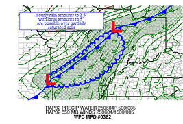
...Southern Plains, Lower-Mid Mississippi Valley, Great Lakes...
The cold front over the central CONUS will continue on its trek
eastward today, but will start to slow and become aligned more west
to east as its tail gets pulled northward by an approaching
shortwave over the Four Corners region. Shortwaves embedded within
the flow will continue to race northeast, especially from Missouri
to Michigan, which is where the greatest concentration of t'storms
is expected. Storm motions along the front are likely to be
progressive, lifting off to the northeast on 0-6km mean winds of
20-30 kts, but weaker Corfidi vectors aligned both to this mean
wind and the front suggests a potential for training. A SLGT risk
was introduced for southeast MO into southern IL, where HREF
exceedance probs for 3" and 5" thresholds are concentrated (30-60%
and 10-30%, respectively). Much of these totals may occur over a
relatively short period of time, as 1-2"/hr rainfall rates locally
train/repeat over the same areas.
Farther south into the Southern Plains, thunderstorms from this
morning should tend to wane over time, but will present a localized
flash flood threat through about 15z (with the HREF indicating some
potential for redevelopment after 00z, though FFGs are much higher
in this region).
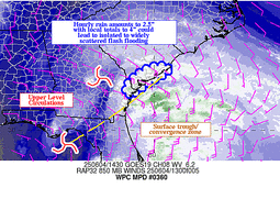
...Southeast...
An inverted surface trough crossing the northern FL Peninsula with
an accompanying mid-upper low (centered near the Big Bend) will
shift northeast along the FL/GA/SC coasts, having already drawn
substantial tropical moisture northward (along with accompanying
showers and thunderstorms). While the NHC continues to indicate a
10% probability of tropical or sub-tropical development in
association with this feature, heavy rainfall is increasingly a
concern (whether or not a circulation ultimately forms, though a
non-tropical low is expected to). While the bulk of the heavy
precipitation is still expected to occur mainly offshore of (with
the most significant HREF signal offshore of SC, specifically),
there are concerns that prolonged heavy rainfall could impact
portions of the coastline. A SLGT risk was introduced to coastal
portions of SC, where rainfall totals in excessive of 5" are most
likely to occur (per HREF exceedance probs of 20-30%, which is also
in-line with the corresponding 10-yr ARI and co- located with the
best EAS probs, indicating relatively good spatial agreement as
well). This includes the relatively sensitive Charleston metro
area, and any localized flooding impacts may be exacerbated by
high tide. Outside of this specific area, locally heavy rainfall
could result in more isolated instances of flash flooding across
much of FL and adjacent portions of southeast AL, southern and
central GA, and into more of SC/NC (depending with the northern
extent of the MRGL largely dependent on timing differences with the
northward progression of convection). Local 3" exceedance probs
are relatively high throughout this region (20-60%), though absent
of significant convective organization these totals should largely
be below the relatively high FFGs that prevail (which are as high
as 4-5" over 6-hr).
Churchill
Day 1 threat area:
www.wpc.ncep.noaa.gov/qpf/94epoints.txt
Excessive Rainfall Discussion
NWS Weather Prediction Center College Park MD
1210 PM EDT Wed Jun 4 2025
Day 2
Valid 12Z Thu Jun 05 2025 - 12Z Fri Jun 06 2025
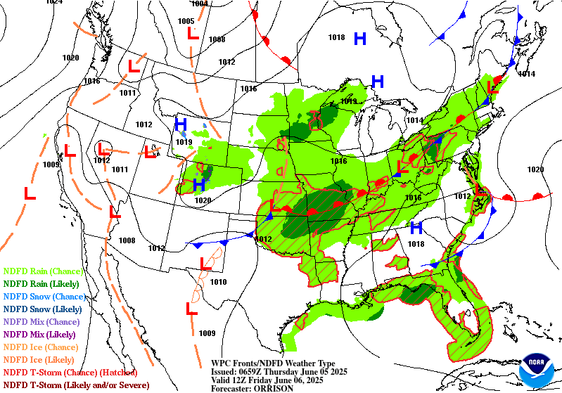
...THERE IS A SLIGHT RISK OF EXCESSIVE RAINFALL FOR PORTIONS OF
THE SOUTH-CENTRAL PLAINS...
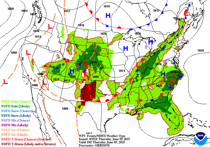
...Intermountain West to Central/Southern Plains...
Thursday/Day 2 should see a similar pattern as Wednesday/Day 1,
with a broad positively tilted trough axis across the West and
shortwaves moving through. Pacific moisture (continuing to be over
the 90th percentile for PWs, and as high as the 99th percentile,
per NAEFS) will stream northeastward just ahead of the trough to
produce scattered convection across the central Great Basin toward
the central Rockies, where the Marginal Risk has been maintained
(and adjusted to the latest data).
Farther east, an initial shortwave will force convection in the
southern High Plains tonight into Thursday morning, then a renewed
low-level jet (30-40 kts at 925-850mb) will push moisture and
instability a bit farther north into Oklahoma/Kansas Thursday
night. This will likely sustain convection (or perhaps reinitiate
convection from a remnant MCV) that originates in CO/NM, leading
to heavy rain rates (that potentially persist and repeat over the
same areas). While there continues to be spread in the guidance
regarding whether there are ultimately two separate areas of
convection (one near the TX Panhandle and Permian Basin and another
near the KS/OK border) or one more consolidated area of convection
(likely somewhere inbetween), have maintained and adjusted the
associated SLGT risk (which is centered near the highest ECENS 2"
and 3" exceedance probs). Further refinements are expected with the
addition of the remainder of the CAM suite later today (and could
result in higher confidence of upper-end SLGT probabilities, should
CAMs come into relatively good agreement).
...Ohio/Tennessee Valleys and Lower Great Lakes...
Moisture pooling along a meandering front may lead to loclatestally
heavy rain across the Mid-Lower MS Valley and OH/TN Valleys toward
the Lower Great Lakes region. A Marginal Risk was adjusted
eastward across this region from prior cycles, owing to trends in
the placement of the frontal zone. Still considered a Marginal Risk
stretching into northern New England near/ahead of the front where
above normal moisture and instability are likely, but have judged
model QPFs remain not too heavy. There is likely a non-zero
probability for localized flash flooding, which will continue to be
monitored.
...Southeast/Carolina Coast...
A non-tropical low pressure system is forecast to be tracking just
onshore in the Carolinas on Thursday, and models continue to
indicate significant rainfall totals mainly just offshore in
association with tropical moisture. While this system is most
likely to remain frontal/baroclinic in nature, there is still a
low-end chance (near 10% per the NHC) of a tropical or sub-tropical
low consolidating within the persistent tropical convection offshore.
Even though the heaviest rainfall totals are forecast to stay
offshore, wraparound moisture is expected to stream into coastal
areas with PWs near the 95th percentile (per NAEFS). Have
maintained a MRGL risk for the new Day 2, owing to uncertainties
with regard to how things ultimately develop, but current ensemble
probs (available CAMs and GEFS/ECENS) suggest 2-3" areal averages
for the NC coast (which has the greatest chance of being locally
upgraded to a SLGT with subsequent updates). Farther west and south
of the low, lack of instability and focused low-level moisture
transport looks to limit rain rates and subsequent totals (though
lingering flooding may still be ongoing from D1 rainfall).
Churchill/Tate
Day 2 threat area:
www.wpc.ncep.noaa.gov/qpf/98epoints.txt
Excessive Rainfall Discussion
NWS Weather Prediction Center College Park MD
1210 PM EDT Wed Jun 4 2025
Day 3
Valid 12Z Fri Jun 06 2025 - 12Z Sat Jun 07 2025
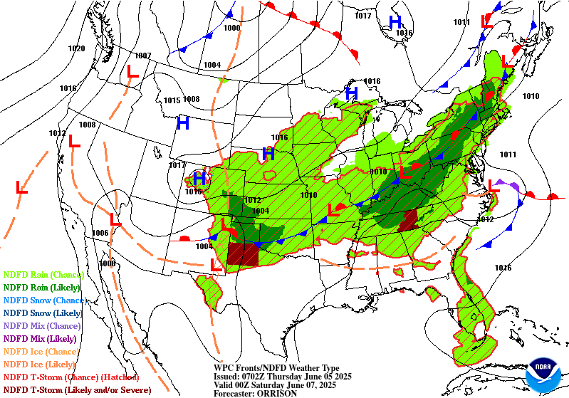
...THERE IS A SLIGHT RISK OF EXCESSIVE RAINFALL FOR MUCH OF
OKLAHOMA...
...Southern Plains...
Convection looks to remain active in the Southern Plains from
overnight Thursday into Friday morning, fueled by a 30-40 kt low-
level jet and likely ongoing MCS(s). In addition, the trailing
frontal zone is unlikely to move much as the upper-level pattern
remains blocky. Models indicate that another shortwave could fuel
yet more organized convective coverage into Friday night, this time
originating from the northern stream and digging southeastward from
the central Rockies/High Plains. The LLJ should reinvigorate once
again, and this is a recipe for heavy rainfall with training and
repeating over many of the same areas a distinct possibility. While
there is a fair amount of spread in the global guidance at this
range with QPF output, the consensus cluster is pretty well
situated over central OK (with some solutions suggesting farther
eastward progress of high totals into portions of northwest AR and
southwest MO). Maintained the inherited SLGT risk over the best
ensemble signal (where 00z GEFS/ECENS 2" and 3" exceedance probs
overall quite well). As confidence increases, the SLGT risk region
may expand (with potential for a targeted Moderate upgrade in
subsequent outlooks, depending largely on how much rainfall
transpires on Thursday and how well QPF on Friday overlaps).
...MS/TN/OH Valleys into Great Lakes and Appalachians...
Moisture looks to continue to pool along a meandering front in
this blocky pattern, which may continue to lead to locally heavy
rain across the Lower-Middle MS Valley and OH/TN Valleys toward
the Lower Great Lakes region. The MRGL was maintained and adjusted,
and subsequent targeted SLGT(s) may be necessary with increasing
overall PWs and the potential for localized totals beginning to add
up from multiple days. In addition, expanded the inherited MRGL
risk eastward into much of the Appalachians, as models come into
better agreement that better moisture and subsequent convection
will start to move into those more sensitive areas.
Churchill
Day 3 threat area:
www.wpc.ncep.noaa.gov/qpf/99epoints.txt
Extended Forecast Discussion
NWS Weather Prediction Center College Park MD
220 AM EDT Wed Jun 4 2025
A non-tropical low is expected to develop offshore the Southeast
coast prior to the extended. The National Hurricane Center is
monitoring this feature for the potential to transition into a
subtropical or tropical low. Deepest moisture may stay offshore
and uncertainty is high, but there is a chance of some heavier
rainfall along the coast.
Pooled moisture across the central U.S. will help convection fire
up along a slow-moving and wavy front that will stretch from the
Northeast and Ohio Valley states down to the Southern Plains.
Locally enhanced rainfall will be supported thanks to steady
advection from the Gulf coupled with shortwave/jet. Conditions
will be favorable for hourly rates of 1 inch/hour or greater. WPC
has a broad Marginal Risk spanning from the Plains to the Great
Lakes/Northeast into the weekend. Within the Marginal is a smaller
area highlighted with a Slight Risk of excessive rainfall mainly
for Oklahoma, but also into the adjacent counties of Arkansas and
southwest Missouri. The southern trailing tail of the elongated
boundary will stall and weaken over the southern Plains. Dynamic
upper closed low/trough digging into the north- central U.S. from
the weekend into early next week will spawn fronto/cyclo genesis,
with baroclinicity rejuvenated more broadly again that may act to
spread heavy rainfall focus across the Mid- South and Tennessee
Valley then down across the Mid- Atlantic and the South/Southeast.
Summer heat will build across the Interior Northwest/West and into
the Desert Southwest with establishment of mean upper ridging over
the weekend into next week. Maximum temperatures over the interior
Northwest may range upwards to 20-25F degrees above normal. Areas
from south Texas into the Gulf Coast will also experience rising
temperatures, cresting upwards of 105F by the weekend over South
Texas to push heat index values dangerously upwards to 110-115F.
Please take heat safety precautions such as increased water intake
and more time in air conditioned areas to avoid heat exhaustion
and heat stroke. See weather.gov/heat for more information on
safety tips and resources.
Campbell/Schichtel


