Excessive Rainfall Discussion
NWS Weather Prediction Center College Park MD
854 PM EDT Mon Jun 9 2025
Day 1
Valid 01Z Tue Jun 10 2025 - 12Z Tue Jun 10 2025
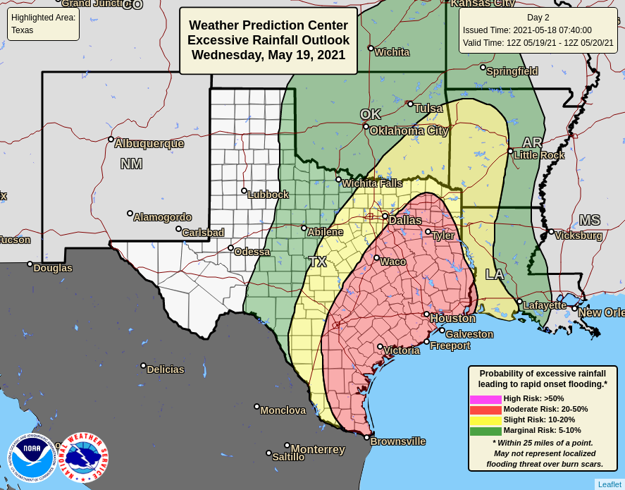
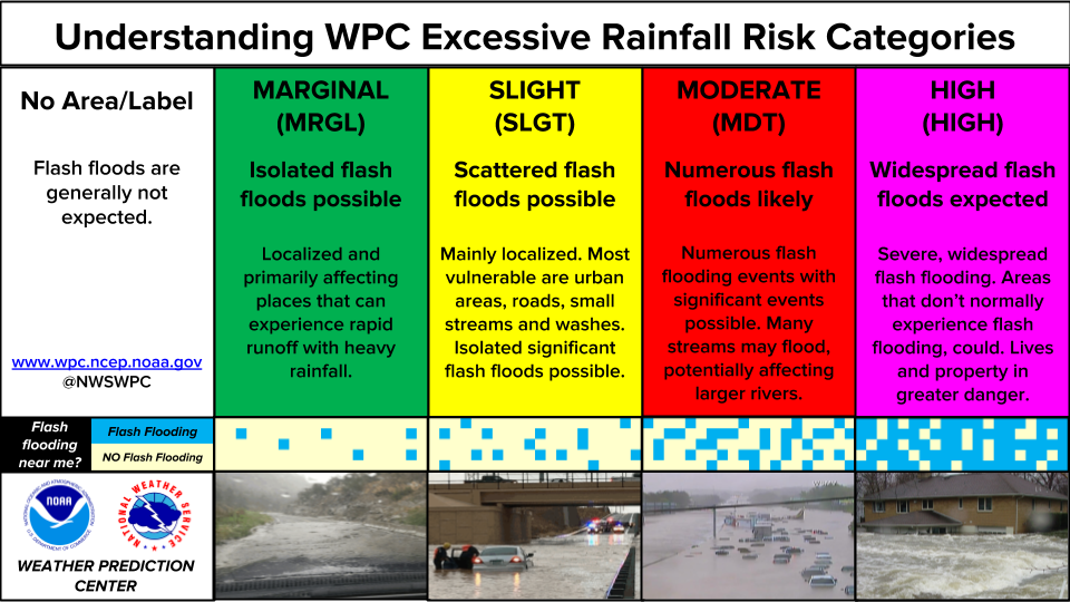
...THERE IS A SLIGHT RISK OF EXCESSIVE RAINFALL FOR PORTIONS OF THE
NORTHEAST, SOUTHEAST, GULF COAST, AND SOUTHERN PLAINS...
...01Z Update...
Cut back on the western portions of the Slight and Marginal Risk
areas across the OH Valley into western NY-PA, while also
extending the Slight a little farther south to include more of
western MD and a portion of northeast WV and far northwest VA. This
largely based on observational and HRRR trends, with MPD #413 in
effect through just after midnight EDT. Elsewhere, more minor
modifications were made, again per the latest guidance and
observational trends, including the latest (18Z) HREF exceedance
probabilities.
Hurley
Previous discussion below..
...Northeast...
Occluded low over Wisconsin this morning will track northeast over
the U.P. of Michigan tonight. South and east of the low, upper
level divergence and forcing will be maximized as a 100 kt jet
streak and enhanced divergence from a shortwave rounding the
southern side of the low will increase the forcing for thunderstorms
in the Slight Risk area of Pennsylvania and western New York. At
the surface, a potent cold front will be moving east from the Great
Lakes/Midwest and into Pennsylvania and New York. The front will
contribute additional forcing for storms. Somewhat limited Gulf
moisture will stream northward ahead of the front, raising PWATs up to
1.5 inches (1.5 sigma above normal). Instability will also
increase with daytime heating with MUCAPE values between 500 and
1,500 J/kg, with the greatest instability into Pennsylvania.
12Z CAMs generally agree that the current activity moving from Ohio
intensifies diurnally across PA and NY. Soil moisture is elevated
from recent rains, though storms will be quick- moving, which
should temper the flash flooding threat somewhat. However,
topographic and urbanized concerns warrants maintenance of the
Slight Risk with some further trimming out on the eastern side in
NY per coordination with WFO BTV.
...Southeast...
Multiple rounds of heavy thunderstorms are expected to traverse
across the Southeast through. Ample Gulf moisture is being supplied
on strong (30kt) low level flow with as PWATs 1.75 to 2 inches
over MS/AL/GA where activity should focus/repeat. Meanwhile, a
potent shortwave at the base of the trough currently over the
lower-mid Miss River and cold pool interactions from ongoing
activity will force additional convection. As the shortwave crosses
the Southeast this evening, the storms should evolve upscale from
random clusters to lines. As the surface cold front begins to
stall, backbuilding storms will become increasingly possible in
many of the same areas of southern Mississippi to the western
Florida Panhandle that saw convective activity this morning.
Widely scattered instances of flash flooding can be expected inland
from the central Gulf Coast where a Slight Risk is maintained.
...Texas and New Mexico...
12Z CAMs continue to ramp up convective activity today developing
this afternoon off the southern Rockies with organized thunderstorm
clusters shifting southeast over west into central TX overnight.
Much of this activity is west/south of heavy precip from recent
days, but given Gulf-sourced moisture extending up through west
Texas (1.5 sigma above normal) and high instability, the Slight
Risk is maintained and expanded a bit more into central Texas for
overnight concerns.
Furthermore, a boundary around the Houston metro activates this
afternoon with a risk for repeating heavy thunderstorms there. A
Slight Risk was raised around the greater Houston metro.
Wegman
Day 1 threat area:
www.wpc.ncep.noaa.gov/qpf/94epoints.txt
Excessive Rainfall Discussion
NWS Weather Prediction Center College Park MD
854 PM EDT Mon Jun 9 2025
Day 2
Valid 12Z Tue Jun 10 2025 - 12Z Wed Jun 11 2025
...THERE IS A SLIGHT RISK OF EXCESSIVE RAINFALL FOR SOUTHEASTERN
NEW MEXICO AND WEST TEXAS...
21Z Update...
...South-Central U.S./Texas...
Yet another round of widespread heavy thunderstorm activity
Tuesday over portions of the south- central CONUS. Diurnal activity
originating on the Sacramento Mtns in NM will shift southeast over
west TX through the evening. Abundant Gulf moisture remains over
the area south of a stationary front over northern Texas. Storms
will blossom in coverage towards sunset as the LLJ of additional
Gulf moisture strengthens. The convection will both interact with
the stationary front, a possible dryline in southeastern NM and far
west Texas, and some subtle, but still important upper level
impulses that eject out of the southern Rockies.
The main change with 12Z guidance, particularly with CAMs today has
been a focus farther south...south of the TX Panhandle. Therefore
the northern portion of the Slight Risk was trimmed south with a
bit more of the Rio Grande downstream of the Big Bend included.
...Gulf Coast and Eastern Seaboard...
The Marginal Risk along the Gulf Coast and eastern seaboard again
remains largely unchanged. Main risks include ongoing storms in
New England at the start of the period, with some chance for
largely disorganized convection from the Gulf Coast to the
Carolinas. While some of these areas have also been hard hit with
heavy rains in recent days, the lack of confidence in much
organization to the storms favors a continuation of the Marginal
Risk. Cell interactions are still likely to cause localized Slight
Risk-level impacts along the Gulf Coast, but uncertainty remains at
this time.
Wegman/Jackson
Day 2 threat area:
www.wpc.ncep.noaa.gov/qpf/98epoints.txt
Excessive Rainfall Discussion
NWS Weather Prediction Center College Park MD
854 PM EDT Mon Jun 9 2025
Day 3
Valid 12Z Wed Jun 11 2025 - 12Z Thu Jun 12 2025
...THERE IS A SLIGHT RISK OF EXCESSIVE RAINFALL FOR PORTIONS OF
TEXAS AND OKLAHOMA...
21Z Update...
...Southern Plains/Texas/Gulf Coast...
Deep Gulf moisture will advect north across much of Texas and the
Southeast on Wednesday. Slow- moving upper level shortwave energy
will shift east across Texas through the period. The stationary
front that had been across north-central Texas for much of the
prior two days should begin to lift north as a warm front,
especially Wednesday night as the nocturnal strengthening of the
LLJ overcomes what little southward push of drier air north of the
front is left. Meanwhile across West Texas, the typical dry line
will also advance eastward, which will work to uplift the moisture
and cause more widespread shower and thunderstorm activity. While
the storms may be around in isolated clusters through the day, the
greatest concentration of storms should initiate in the late
afternoon and persist through the overnight. There is potential for
some of the same areas of northern Texas will be hit with multiple
rounds of storms once again. A higher-end Slight is in effect for
portions of North Texas into southern Oklahoma.
The main note for this area is guidance has wide variation of the
main QPF axis. This includes the experimental RRFS which for 12Z
highlights eastern Texas only for higher rainfall. However, global
and regional models are farther west/north. Since uncertainty
reigns, only small modifications to the Slight Risk were made -
generally an east shift.
The Marginal Risk was expanded east over the central Gulf Coast
based on confidence of higher QPF inland from the coast.
...Upper Midwest...
Up north towards the MN/IA border and southern WI, a subtle
shortwave in the jet will interact with a weaker portion of the LLJ
which will run into a drier air mass to the north. Showers and
storms may train eastward across this region. However, instability
will be a tremendous limiting factor in the potential for flash
flooding. Soils are at or below normal for moisture in the area,
which also will not help with flash flooding potential. A Marginal
Risk remains in effect with a minor south expansion based on 12Z
consensus including the ECMWF and GFS.
...Montana/Northern Rockies...
Further south and east expansion of Marginal risk into the northern
Plains and northern Rockies. Areas of convection will cross MT
through the period, but the main concern at this time is coverage
which may be somewhat limited. Low FFGs over this area could allow
for isolated instances of flash flooding where there are favorable
cell and terrain interactions.
Wegman/Jackson
Day 3 threat area:
www.wpc.ncep.noaa.gov/qpf/99epoints.txt
Extended Forecast Discussion
NWS Weather Prediction Center College Park MD
256 AM EDT Tue Jun 10 2025
An unsettled weather pattern is expected to be in place across a
large portion of the Central U.S. to close out the work week.
Additional heavy rainfall is likely across the Arklatex region
going into the new Day 4 period Friday with a southern stream
shortwave positioned over Texas. The Slight Risk inherited from the
previous Day 5 outlook will be maintained for Friday, where the
potential exists for 1-2 inches of rainfall from potential MCS
activity, and this would be falling atop soils that will probably
be saturated owing to rainfall in the days leading up to this.
There should also be at least scattered showers and storms from the
western Gulf Coast and extending northward across the Mid-South, so
the Marginal Risk area has been expanded. Farther to the north
across the Upper Midwest and Great Lakes, a wave of low pressure
along a quasi-stationary boundary should fuel the development of
scattered to numerous showers and some thunderstorms from Wisconsin
to Lower Michigan, and a Marginal Risk of excessive rainfall
remains valid here on the Day 4 outlook. Going into Day 5 Saturday,
a broad Marginal Risk area is planned from the central Gulf Coast
to western New York where the QPF guidance shows the best signal
for more organized convection, although nothing rises to the level
of needing a Slight Risk yet. This will continue to be monitored.
Temperatures will continue to be quite warm across much of the
Intermountain West for the entire forecast period as this region
will be under the influence of an upper ridge, although a slow
moving cold front from the Pacific will keep readings closer to
climatology from the Pacific Northwest to western Nevada/northern
California. Heat will also be building across the Desert Southwest
with highs making a run at 110 degrees for the lower elevations of
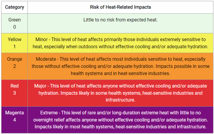
southern Arizona and southeast California, with Heat Risk likely
reaching the major category by Sunday into Monday. Meanwhile,
slightly below average temperatures are likely from the Upper
Midwest to the Great Lakes and northern New England going into the
weekend as this region will be north of the main frontal boundary.
Hamrick
