Excessive Rainfall Discussion
NWS Weather Prediction Center College Park MD
340 AM EDT Wed May 28 2025
Day 1
Valid 12Z Wed May 28 2025 - 12Z Thu May 29 2025
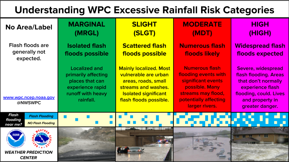
...THERE IS A SLIGHT RISK OF EXCESSIVE RAINFALL ACROSS PORTIONS OF
CENTRAL AND COASTAL TEXAS...
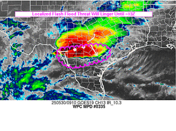
...Central and Coastal Texas...
Energy ejecting out of Coahuila tonight will migrate southeast
towards Deep South TX before turning east-northeast around the
western periphery of a ridge positioned over the Caribbean. Deep
moisture advection regime will be ongoing through the period with
PWAT's between 1.9-2.2" likely across all of South TX with some
localized maxima exceeding 2.2" likely when assessing the latest
CAMs output. This puts the Texas coastal plain with a +2 deviation
anomaly moisture wise, indicative a fairly unstable environment
prior to the approach of the expected shortwave. MUCAPE between
3500-4500 J/kg is forecast over the Lower RGV up through the TX
coast with the highest forecast in proxy to the immediate coast and
southern-most portion of the Rio Grande. Hi-res deterministic QPF
shows a bullish depiction of local 4-6" maxima cropping up near and
over some of the urban centers within the above zone, including
places like McAllen, Corpus Christi, and nearby the Houston Metro.
These areas are more prone to flash flooding due to the urban
footprint providing higher runoff capabilities, but also the
previous evening's MCS that blew through the area truly cut the FFG
indices ~50% compared to where they were even 48 hrs. prior. The
1/3/6 hr. indices are well within reach considering the blended
mean QPF output over these areas are now between 2-3" with local
maxima littered across the region. Neighborhood probs from the 00z
HREF painted a broad 50-80% area for >3" with the entire coastal
plain highlighted from South Padre up through the Upper Texas
coast. Considering consensus from latest hi-res
deterministic/ensemble combo and pertinent prob fields, and in
coordination with the coastal TX WFO's (BRO/CRP/HGX), a SLGT risk
was added along a vast majority of the TX coastal plain with
emphasis on higher potential inside the urban zones.
Further northwest, another shortwave will exit off the TX Caprock
with a steady migration eastward through the northern Concho
Valley, eventually into Big Country and Central TX late-afternoon
Wednesday. A well-defined theta_E ridge will bisect much of Central
TX, arcing northwest through Northwestern TX leading to a tongue
of elevated instability characterized by a persistent corridor of
2000-3000 J/kg SBCAPE when assessing the 00z CAMs. This is defined
very well within the ensemble mean SBCAPE output with a 90th
percentile output closer to 4000 J/kg positioned between San
Angelo/DFW/Austin when taking a look at the spatial SBCAPE max from
the 00z HREF. This area has been impacted for multiple days with
locally heavy rainfall bringing regional QPE between 2" to as much
as 8" in the last 72 hrs. This has prompted FFG responses to drop
considerably with even the 3hr FFG marker a paltry 2-3", a far cry
from the ~5" marker just a few days ago. Streamflows across the
region impacted are relatively high as well meaning the threat is a
bit more pronounced when you take everything into account. Precip
means are between 1-1.5" with some local maxima of up to 4" showing
up in the CAMs, especially in the area between DFW and Austin, near
and along I-35. Hourly rates will be driver of the threat, but
there's plenty of favor for 2-3"/hr rates considering the
environment. In coordination with some of the local WFO's
(FWD/SJT/EWX), a SLGT risk was added to portions of the Concho
Valley, Southern Big Country, and Central TX with emphasis on that
area near and along I-35 between DFW/Austin.
...West Texas and New Mexico...
Persistence in a narrow theta_E ridge from West TX up through the
Southern Rockies will lead to another shot at scattered
thunderstorms over the terrain with locally heavy rainfall causing
some flash flood concerns in complex topography. Remnant burn scars
up over Northern NM have been hit recently with high runoff
capabilities leading to flash flooding in those targeted zones.
This threat will remain for D1 with some isolated heavy cores also
possible as far south as the Sacramento Foothills.
West Texas will see an initiation of thunderstorms across the
western half of the TX Big Bend up through the western Stockton
Plateau and adjacent terrain of Southwest TX. Threat is very
localized, but considering the environment in place, any cells will
have the opportunity for a quick 1-2" of rainfall that would
ultimately cause issues over the area. A relative min in QPF is
anticipated over the Permian Basin, eastern Big Bend, and the Caprock
area of Eastern NM and High TX Plains. This is well documented
within the QPF distribution allowing for a "donut hole" for a nil
ERO to be positioned in the area of the QPF minimum. Despite a
relatively sporadic coverage, the potential for heavy rates between
1-2"/hr will be the key for any flash flood potential, outside burn
scar locales. The previous MRGL risk was generally maintained with
only some minor adjustments near the nil ERO area.
...High Plains...
A shortwave currently analyzed over the High Plains of Canada will
get caught in the western periphery of a broad ULL positioned over
the Midwest leading to pieces of energy fragmenting off the main
vorticity lobe and pivoting south and southeast through High Plains
of MT/WY later this morning. As the energy moves over the WY/CO
Front Range, convective initiation will occur with cold pool
maturation and consolidation likely leading towards a defined MCS
as we move into the second half of the period. Consensus was
maintained across all major deterministic on the upscale growth of
any convective segment sliding down prevailing northwesterly
steering flow aligned across Northeast CO down through Western KS
as we move into nightfall. As the complex loses latitude and
reaches the southern periphery of the sprawling ULL, the
disturbance will slow and eventually pivot eastward allowing a
short-term training axis to occur over South-Central KS. There has
been a minor displacement of the previous QPF maxima with the 00z
hi-res suite insinuating the maxima be positioned between Dodge
City to Wichita, KS with the magnitude generally between 3-4"
where the heaviest precip occurs. The shift was fairly minor in the
spatial aspects of the forecasts, but hinting at places a little
further east would put areas of South-Central KS closer to needing
a risk upgrade (SLGT) if the trend continues. There is a sharp
delineation between elevated FFG's and lower FFG's within that
part of the CONUS, much of it stemming from a barrage of repeated
convective impacts this past weekend. HREF prob fields are pretty
insistent on at least a widespread 1" of rainfall given the 60-90%
probabilities of >1" in the EAS depiction. The 2" EAS probs,
however are much lighter (10-25%) over the same areas meaning
guidance is still not settled on the QPF "bullseye" in the area. At
this juncture, the threat for a targeted SLGT remains, but the
corridor of where the heaviest rain will occur will likely be more
suited for a MRGL risk with greatest flash flood potential likely
within those Wichita/Dodge City urban zones. The previous MRGL risk
was maintained given the assessment.
...Lower Mississippi Valley and Gulf Coast...
Very little has changed with regards to anticipated complex
developing upstream over TX working its way into the Lower
Mississippi Valley with more heavy rainfall concerns in-of the
energy associated with the progressing complex. This area will have
relatively high FFG's leading in, so the threat will remain fairly
isolated overall with max QPF outputs generally within the 2-4"
range with the heaviest more likely to be closer to the Lower
Sabine than areas further east. Still, there's reasonable consensus
on a smattering of elevated QPF from the expected convective
impacts moving overhead leading to a lower-end MRGL risk for the
Lower Mississippi area, mainly LA. Across the Central Gulf Coast,
heavier cells within a moisture rich environment could spawn over
areas a little more sensitive (urban areas) between New Orleans to
Mobile. The risk is low-end, but some guidance has been trying to
put heavier QPF signatures within proxy of those areas. Steering
flow will be relatively weak so a shot for cells to retain some
longevity over the same areas. A MRGL risk remains in place over
each area.
...Coastal Mid Atlantic...
Surface cyclone will induce a persistent easterly regime off the
Atlantic with a tongue of elevated theta_E's positioned across Cape
Hatteras up through the Hampton Roads area. CAMs are indicating
periods of convection to fire within the confines of these areas
with the large scale forcing increasing as we step into the late-
morning and afternoon periods today. General QPF maximum (2-3") in
that time frame over Eastern NC up into the Tidewater will have the
opportunity to induce some localized flash flood prospects with
the best risk over the Tidewater where urbanization factors can tip
the scales. The previous MRGl risk inherited was unchanged with
the current QPF footprint and thermodynamic regime still in play
after assessment of the 00z deterministic suite.
Kleebauer
Day 1 threat area:
www.wpc.ncep.noaa.gov/qpf/94epoints.txt
Excessive Rainfall Discussion
NWS Weather Prediction Center College Park MD
340 AM EDT Wed May 28 2025
Day 2
Valid 12Z Thu May 29 2025 - 12Z Fri May 30 2025
...THERE IS A SLIGHT RISK OF EXCESSIVE RAINFALL ACROSS PORTIONS OF
THE SOUTHEAST...
...Southeast U.S...
The combination of shortwaves ejecting eastward out of the Southern
Plains and the approach of a cold front from the north will lead to
ample ascent between sfc-500mb along a stretch of elevated moisture
between +1 to +2 deviations in PWAT anomalies. Consensus has
increased in a broad, scattered convective regime from the Lower
Mississippi Valley into the Southeastern U.S. leading a potpourri
of QPF maxima within areas of convective impact. Signals at the end
of the 00z HREF were quite bullish in the 12-hr window from 12-00z
Thu/Fri with neighborhood probabilities for >3" between 35-60%
across several small areas over the Central Gulf Coast, including
some "bullseye" patterns within a few urban centers between Baton
Rouge to Tallahassee. Thunderstorm concerns will continue until the
front passes through any specific area south of I-40 in the
period, so the prospects for local maxima capable of flash flooding
are elevated when you add the lower FFG indices currently in place
between MS/AL. This will come after seemingly 3 straight days of
heavy rainfall at any point in time for the region, so the FFG
recovery is pretty unlikely at this juncture. The previous SLGT
risk inherited was generally maintained, but did expand west given
the timing of the approaching shortwave out of TX and the
accompanying higher QPF signatures over LA between 12-18z Thursday.
...Ohio Valley...
A broad ULL positioned over the Midwest will pivot southeast with
a positioning across the Mid-Mississippi and Western Ohio Valley
through D2. Large scale forcing under presence of the ULL will
generate periods of convection across the above areas with a focus
on MO/IL/KY/IN. QPF maxima based on the ensemble bias corrected
output was between 1.5-2.5 over Central Ohio Valley with highest
signature over the Ohio River basin. The current outlook is still
within the MRGL risk threshold due to the lower instability
presence at the surface as much of the ascent is rooted in the mid
to upper levels given the ULL/trough influence. The previous MRGL
risk was relatively unchanged with only minor tweaks around the
periphery to account for the latest heavy QPF distribution.
...Texas...
More convection is expected over the Lone Star State on Thursday
afternoon through the end of the period. West TX will be the
initiation point with convection firing in-of the theta_E ridge
positioned over the Big Bend up through the Pecos River Valley. A
cold front will be pressing in from the north with a sharp cutoff
of any instability presence as MUCAPE will flat-line with fropa as
drier air advects behind the front. The best threat for convection
will likely occur over Southwest TX with some question as to
whether the cold front will subdue convective concerns for areas
north of I-20 by the second half of the forecast. Guidance is split
on how it wants to handle the shallow cold push with the NAM Nest
the most aggressive in its latitudinal push and globals lagging
enough to warrant storm threats as far north as the Caprock. For
now, left a broad MRGL over the region, but there will likely be
some fluctuations in the northern periphery of the MRGL risk area
in place. Will be monitoring over the next succession of updates.
Kleebauer
Day 2 threat area:
www.wpc.ncep.noaa.gov/qpf/98epoints.txt
Excessive Rainfall Discussion
NWS Weather Prediction Center College Park MD
340 AM EDT Wed May 28 2025
Day 3
Valid 12Z Fri May 30 2025 - 12Z Sat May 31 2025
...THERE IS A MARGINAL RISK OF EXCESSIVE RAINFALL ACROSS PORTIONS
OF THE MID ATLANTIC, OHIO VALLEY, AND SOUTHEAST...
A potent mid-latitude trough will pivot through the Ohio Valley on
Friday morning with a broad axis of diffluence downstream of the
mean trough leading to a large scale forcing regime that will
enhance regional precip field across the Mid Atlantic. At the
surface, low pressure will navigate into the Mid Atlantic with a
trailing cold front migrating eastward through much of the Eastern
CONUS, interacting with a wedge of low to mid-level instability
situated over the Central/Southern Appalachians and points east.
Greatest thermodynamic alignment will likely be closer to the
coastal plain, but elevated MUCAPE signatures can be found within
the Mid Atlantic Piedmont and under the primary trough. The
tandem of increased sfc-500mb forcing from the trough/front combo
will lead to a scattered to widespread convective pattern that will
induce locally heavy rainfall and potential for flash flooding.
Timing of the ascent pattern and frontal progression will be key in
determining the logistics of where the main axis of convection will
occur. As of now, the best chances for convectively driven heavy
rain are within the Central and Southern Appalachians, Southern VA
through the NC Piedmont, and the Eastern Carolinas up to the VA
Tidewater. These are the areas conducive for flash flooding at this
time with localized amounts reaching 2-3" in the places hit the
hardest. 1-2" is more likely out in the terrain of the Apps, but
that is a signal sufficient for flashier responses due to the
complexity of the topography. Despite the questions of timing, the
threat remains leading to a broad MRGL risk over much of the Mid
Atlantic with a southern inflection down towards FL as the trailing
front will move through the region and interact with a deeper
moisture layer and plentiful instability to induce some heavier
convective cores capable of flash flooding in more urbanized zones.
Kleebauer
Day 3 threat area:
www.wpc.ncep.noaa.gov/qpf/99epoints.txt