Excessive Rainfall Discussion
NWS Weather Prediction Center College Park MD
850 PM EDT Sat May 31 2025
Day 1
Valid 01Z Sun Jun 01 2025 - 12Z Sun Jun 01 2025
...THERE IS A MARGINAL RISK OF EXCESSIVE RAINFALL OVER PORTIONS OF
THE SOUTHERN PLAINS...
...01Z Update...
With rainfall rates gradually diminishing over the Northeast, the
Slight Risk and Marginal Risk over northern New England have been
taken out. While some localized ponding or run-off along complex
terrain in the Green/White Mountains and across northern Maine
cannot be ruled out, rainfall rates have diminished to the point
where the flash flood potential is effectively done. In the Central
Plains, the Marginal Risk was only tweaked after viewing 18Z HREF
guidance and new CAMs guidance.
Mullinax
--Previous Discussion---
...Southern Plains...
Broad NW flow on the upwind side of an expansive trough centered
over Ontario will persist over the Plains as an embedded but
potent shortwave tracks SE tonight. This shortwave will push a
wave of low pressure and weakening cold front south into Oklahoma
tonight, where it will interact with a slowly advancing warm front
out of Texas on the intensifying LLJ. This LLJ, progged to reach at
least a modest 20-25 kts from the SW, will transport more robust
thermodynamics (PWs to 1.5 inches and MUCAPE above 1000 J/kg), to
support expanding convection along this decaying cold front. With
bulk shear expected to be in the 30-40 kt range, convection will
likely grow upscale into clusters or an MCS tonight as it races
southeast on 20-25 kts of 0-6km mean winds. This this will limit
the duration of heavy rain, rates that will likely reach 1-2"/hr
could result in isolated instances of flash flooding, especially
during any short-term training that may develop on the periphery of
this MCS. The guidance, as expected, features considerable
longitudinal spread of the MCS path, which makes the cosmetic
adjustments to the inherited MRGL risk the best approach for the
risk area tonight.
Weiss
Day 1 threat area:
www.wpc.ncep.noaa.gov/qpf/94epoints.txt
Excessive Rainfall Discussion
NWS Weather Prediction Center College Park MD
844 PM EDT Sun Jun 1 2025
Day 1
Valid 01Z Mon Jun 02 2025 - 12Z Mon Jun 02 2025
...THERE IS A SLIGHT RISK OF EXCESSIVE RAINFALL OVER PORTIONS OF
THE SOUTHERN ARIZONA...
...01Z Update...
No changes were needed across the Southwest with this updated as
the rainfall event is well underway across the region, but behaving
as forecast.
East from there across Texas however, slow-moving and some training
storms have developed near and just south of the Metroplex.
Isolated flash flooding is possible with any repeating rounds of
storms, so the Marginal Risk was shifted west to align with current
radar trends. Guidance suggests the storms should begin to turn and
move southward with time, dissipating in a few hours with the loss
of diurnal heating.
The Marginal in Florida was dropped with this update as all
significant convective activity in the state has ended.
Wegman
Day 1 threat area:
www.wpc.ncep.noaa.gov/qpf/94epoints.txt
Excessive Rainfall Discussion
NWS Weather Prediction Center College Park MD
844 PM EDT Sun Jun 1 2025
Day 2
Valid 12Z Mon Jun 02 2025 - 12Z Tue Jun 03 2025
...THERE IS A SLIGHT RISK OF EXCESSIVE RAINFALL OVER PORTIONS OF
THE CENTRAL PLAINS AS WELL AS THE SOUTHEAST FLORIDA PENINSULA...
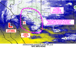
...Central Plains...
Mid-level low over Baja Sunday will fill and eject northeast from
Arizona, reaching the Central Plains by the end of D2. This
evolution will be driven by the amplification of a northern stream
trough digging across Montana, which will help shear out the closed
low and absorb it into the pinched westerlies. The interaction of
these two features will result in widespread convection on Monday
from the Four Corners all the way to the Upper Midwest as ample
moisture from the tropical Pacific streams northward, and impinges
into a cold front being pushed southward by the northern stream
trough.
As the front sags southeast through the day, it will serve as the
primary focus for developing thunderstorm activity Monday aftn and
Monday evening, generally from Minnesota southwest into Colorado.
While there is still considerable spread in the longitudinal
placement of the heaviest rain due to timing differences of the
models, there is good agreement that heavy rain producing
thunderstorms will be widespread along the boundary. This is due to
pronounced ascent through low-level convergence, upper divergence,
and isentropic ascent as the LLJ ramps up and pushes PWs to above
1.5 inches, potentially as high as 1.75 inches across NE/SD, well
above the 90th percentile. This elevated PW will combine with a
ribbon of CAPE above 2000 J/kg to fuel thunderstorms with rain
rates that have a high probability (60-70% chance) of exceeding
1"/hr. With mean winds expected to be 10-15 kts aligned to the
front, but Corfidi vectors becoming increasingly anti-parallel,
some backbuilding into the higher instability and training is
likely. This will support total rainfall that could exceed 3 inches
in some areas, and the SLGT risk was adjusted eastward to account
for the latest guidance from the high plains of CO eastward towards
the Coteau des Prairies.
To the south and west of this SLGT risk, the MRGL risk remains
expansive as far back as the slot canyon region of UT and across
much of CO and northern NM where afternoon thunderstorms could
produce 0.5+"/hr rates atop sensitive terrain leading to instances
of flash flooding. Additionally, a wave of low pressure developing
in the lee of the Southern Rockies may push additional moderate
rainfall across eastern CO late D2, and while this will likely be
less intense due to weaker instability, could produce at least
localized additional flash flooding if the rain occurs atop of
primed soils from earlier convection.
...West Texas...
Convection blossoming along the dry line Monday aftn/eve may become
widespread, although there is quite a bit of spread both in
location, coverage, and intensity, among the various 12Z CAMs.
While the coverage may be somewhat modest, any storms that develop
will be capable of producing intense rainfall rates exceeding
2"/hr as they track to the E/NE at 15-20 kts. Storms on the dry
line will likely organize through 25-35 kts of bulk shear, forming
clusters which could briefly enhance rain rates even further, and
lead to multiple rounds of heavy rain in some areas. FFG from the
Rolling Plains southward towards Big Bend is only 2-2.5"/3hrs due
to 7-day rainfall according to AHPS that has been more than 300% of
normal. This suggests that the inherited MRGL risk is still
warranted for any clusters of storms that move atop these more
sensitive soils.
...South Florida...
An active day of thunderstorms is again expected across South
Florida on Monday as an impressive shortwave tracks overhead and
interacts with a residual front draped across the region. During
the period of peak heating /late aftn and eve/ when SBCAPE will
climb towards 2000 J/kg and PWs surge to nearly 2.2 inches,
approaching the daily record for MFL. The simulated reflectivity
from the available high-res members have become much more
aggressive, likely owing to a more pronounced tail of a jet streak
to the east helping to drive ascent. With mean storm motions (using
0-6km mean winds as proxy) expected to be less than 10 kts within
modest bulk shear of 20-25 kts, clusters of storms that merge with
outflow/sea breeze boundaries could lengthen the duration of
rainfall rates that are expected to reach at least 2"/hr, and
possibly exceed 3"/hr at times. This will result in heavy rain
accumulating to 3-5", with locally higher amounts likely as
reflected by both HREF and REFS 5"/24hr probabilities rising above
60% along the Gold Coast. The inherited SLGT risk was modified only
modestly for the new guidance, and instances of flash flooding
appear likely in the urban areas D2, even moreso if heavy rain
falls atop areas impacted by rainfall on D1 as well.
Weiss
Day 2 threat area:
www.wpc.ncep.noaa.gov/qpf/98epoints.txt
Excessive Rainfall Discussion
NWS Weather Prediction Center College Park MD
844 PM EDT Sun Jun 1 2025
Day 3
Valid 12Z Tue Jun 03 2025 - 12Z Wed Jun 04 2025
...THERE IS A SLIGHT RISK OF EXCESSIVE RAINFALL FOR PARTS OF THE
CENTRAL UNITED STATES AND OVER SOUTH FLORIDA...
...Texas to the Great Lakes...
The cold front pushing southeast across the central CONUS Tuesday
may become more progressive as the Baja low from Sunday gets even
more sheared into the westerlies, producing a more amplified trough
axis pivoting east into the Plains. Embedded within this flow,
multiple vorticity maxima will rotate E/NE, leading to additionally
enhanced lift, aided significantly the latter half of D3 by
diffluence within the RRQ of a poleward arcing jet streak
downstream of the trough axis. This will result in expansive and
impressive deep layer ascent from the Southern Plains through the
Great Lakes, with return flow out of the Gulf on 30-50 kts at 850mb
drawing impressive thermodynamics northward into the front. This
suggests that convection will be widespread across the area
Tuesday, which is supported by both simulated reflectivity and
24-hr rainfall progs from the global models and ensembles, with
rainfall rates exceeding 1"/hr likely anywhere along the front. The
greatest risk for excessive rainfall will be from northern Texas
through eastern Iowa where deeper warm cloud depths will produce
more efficient rainfall rates, which will likely train SW to NE
along the front. The SLGT risk was tailored to match the highest
probabilities for 3"/24 hrs from the ECENS/GEFS, but some eastward
expansion of the SLGT was also drawn to account for the AI guidance
(AIFS, Graphcast) that is generally east of the deterministic
models.
...South Florida...
A meandering shortwave trough positioned over the Florida
Peninsula will be the impetus for another round of scattered to
widespread showers and thunderstorms Tuesday. With thermodynamics
remaining robust across the region (PWs 1.75 to 2 inches and MUCAPE
above 1000 J/kg), slow moving storms will again have the potential
to produce excessive rain rates above 2"/hr. While there is some
uncertainty into how much convective debris from Monday could limit
coverage, the general consensus among the various ensemble camps
is for another day of heavy rain, especially across South Florida,
where ECENS/GEFS/SREF all suggest at least a low end risk (5-10%)
for 3"/24 hrs. This will fall atop ground that will likely be
sensitive from heavy rain on D2, and the inherited SLGT and MRGL
risks were adjusted only cosmetically from previous.
Weiss
Day 3 threat area:
www.wpc.ncep.noaa.gov/qpf/99epoints.txt
Extended Forecast Discussion
NWS Weather Prediction Center College Park MD
247 AM EDT Mon Jun 2 2025
Showers and thunderstorms are expected to focus along a slow-moving
front that will stretch from the Great Lakes to Texas. Gulf
moisture pooling over the region will help prime the environment
for embedded heavy rain potential, especially for parts of Texas
and Oklahoma. We have maintained a broad Marginal Risk of
excessive rainfall and flash flooding for this region with a
smaller (and less certain) Slight Risk where heavier rainfall is
more likely at this point. However, this will likely be subject to
change as lead time decreases.
Rain will spread into the Northeast over the weekend as the
northern portion of the front advances eastward. The southern tail
of the boundary will lift as a warm front as heights rise over
Mexico/southern Texas, allowing the heavier rain potential to move
both northward (into the Central Plains) but also spill eastward
into the Mid-South.
Heavy rainfall may impact portions of the Southeast Coast thanks to
a lingering/weakening frontal boundary lifting northward beneath a
weakness aloft. Moisture may stay offshore and uncertainty is
high, but there is a small chance of some heavier rainfall along
the coast. The Marginal Risk of excessive rainfall was maintained
and expanded a bit further south to include parts of northeast
Florida.
Initially, below normal temperatures will be in place across the
Rockies and Plains on the backside of the frontal boundary. As the
frontal progresses, temperatures will begin to moderate by the end
of the week and into the weekend. Some of the warmest year to
date temperatures will be across much of the Eastern U.S. With
daily readings climbing into the upper 80s to lower 90s there will
be a Moderate level of HeatRisk. Care should be taken to protect
yourself from the hottest part of the day. Areas of south Texas
will see rising temperatures through the late week into the
weekend, cresting 105F by next weekend along the Rio Grande. This
may push heat index values over 110F.
Heat Safety -- take precautions such as increased water intake and
more time in air conditioned areas to avoid heat exhaustion and
heat stroke. See weather.gov/heat for more information on safety
tips and resources.
Campbell/Fracasso


