Excessive Rainfall Discussion
NWS Weather Prediction Center College Park MD
854 PM EDT Fri May 30 2025
Day 1
Valid 01Z Sat May 31 2025 - 12Z Sat May 31 2025
...THERE IS A SLIGHT RISK OF EXCESSIVE RAINFALL FOR PORTIONS OF THE
OHIO VALLEY THROUGH THE MID-ATLANTIC STATES...
...01Z Update...
The western most flank of the Marginal and Slight Risk areas were
scaled back with heavy rainfall ending there. However, this storm
is quite the dynamic system, highlighted by the 18Z and 21Z WPC
surface analyses showing the minimum low pressure areas dropping
from 1003mb to 996mb. The storm will continue to deepen tonight as
mentioned from day shift with the ECMWF SAT now showing MSLP
values over the Delaware Valley that are near the observed minimums
for this time of year in the CFSR database. As the storm deepens,
intense 850-700mb vertical velocities along the developing occluded
front and triple point will make for a narrow band of efficient
and heavy rainfall rates that could approach 1.5"/hr as it slowly
pivots over eastern PA tonight. RAP soundings north and west of the
Philly metro area do show exceptionally saturated soundings at
low-mid levels that feature warm cloud layers nearly 10,000ft
deep. Instability will be lacking for the most part (<300 J/kg
MUCAPE), but given the robust synoptic-scale forcings at work and
ample moisture aloft, flash flooding very much remains a concern
from the northern Mid-Atlantic into the Northeast tonight,
especially along complex terrain.
Latest 18Z HREF guidance shows a swath of moderate-to-high chance
probabilities (40-70%) for 12-hr rainfall totals >3" from southeast
PA on north through the Lehigh Valley, the Poconos, and into the
Lower Hudson Valley. FFGs are high enough to help limit the areal
extent of potential flash flooding, but recent instances of flash
flooding in northern WV, southwest PA, and near the DC/Baltimore
metro areas serve as a potential precursor to additional flash
flooding tonight. Complex terrain and nearby creeks and streams are
most at-risk for flooding tonight, but urbanized flooding along and
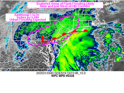
west of I-95 is possible as well. Note that WPC does have Mesoscale
Precipitation (MPD 337) out for portions of the Mid-Atlantic
through 0343Z this evening. Please read the MPD for additional
flash flooding information.
Mullinax
--Previous Discussion--
The regional satellite imagery this morning shows a potent upper
low moving across Ohio, and it is this feature which will help
manifest the flash flood risk from the Ohio Valley into the Mid-
Atlantic and Northeast today. As this low tracks northeast today,
it will move along a baroclinic zone/surface front, helping to
spawn a surface wave of low pressure. This low will track E/NE
along the boundary, moving from eastern KY this morning to western
New England by Saturday morning.
As this low tracks northeast, it will encounter increasingly
favorable thermodynamics, into which forcing will become more
intense, leading to both an expansion and intensification of
convection. The simulated reflectivity from the available CAMs are
relatively similar with widespread showers and thunderstorms
blossoming ahead of the low, and becoming most impressive from
Maryland and points northeast into western New England. This is
supported by more robust thermodynamics being drawn northward,
characterized by a ribbon of elevated PWs of 1.25 to 1.5 inches,
highest east of I-95, and MUCAPE above 1000 J/kg. This will support
rainfall rates for which the HREF indicates have a high a moderate
to high chance (40-70%) of exceeding 1"/hr, and 10-20% chance of
exceeding 2"/hr, enhanced by increasingly impressive synoptic
ascent aided by the LLJ and favorable LFQ of a strengthening jet
streak.
In general, convection which develops downstream of the low will
be progressive on 0-6km mean winds of 20-30 kts. However, aligned
Corfidi vectors suggest some short-term training is possible which
could lengthen these rain rates, or result in repeating rounds in
some areas. Additionally, as bulk shear surges to 40-50 kts,
storms will likely organize into clusters, with an even better
chance for some training along I-95 from Washington, D.C. into
western New England. The simulated reflectivity suggests as the
surface low wraps up a dry slot will pivot in behind the primary
clusters, somewhat reducing the excessive rain risk, but this is
lower confidence, and a stripe of heavy rain of 1-3" is expected,
with locally more than 4" (or even 5") possible from Maryland
through New York as reflected by both the NBMv5.0 and the HREF. The
inherited SLGT risk was modified only slightly for recent
guidance, and expanded a bit northeast into New England.
Weiss
Day 1 threat area:
www.wpc.ncep.noaa.gov/qpf/94epoints.txt
Excessive Rainfall Discussion
NWS Weather Prediction Center College Park MD
427 AM EDT Sat May 31 2025
Day 1
Valid 12Z Sat May 31 2025 - 12Z Sun Jun 01 2025
...THERE IS A SLIGHT RISK OF EXCESSIVE RAINFALL OVER PORTIONS OF
NEW ENGLAND...
...New England...
A deep low pressure system will continue to track northeast today
and tonight over New England in response to favorable ascent from
the right inflow region of an upper jet streak, height falls, and
residual baroclinicity along a cold front while the low- level
flow downstream advects greater moisture and instability northward.
Thermodynamics/static instability look to remain modest as
reflected by forecast PWs of 1-1.25 inches, around the 75th
percentile according to the SPC sounding climatology, and MUCAPE of
around 250 J/kg. This will support generally modest rainfall rates
of 0.5"/hr, but locally higher is possible, especially within any
organized convection on 30-35 kts of bulk shear...with swaths of
1 to 2 inch amounts of rainfall. Maintained the previously issued
Slight Risk area in the complex terrain aiding orographic
processes and the greatest potential for persistent moderate to
heavy rain overlaps the sensitive terrain, and where the highest
HREF probabilities remain for more than 3" of rain exist.
...Southern Plains...
Expansive trough centered over the Great Lakes will lead to lowering
heights over the Plains, with an embedded but potent shortwave
progged to track southward from Nebraska to Texas this evening and
later tonight. This shortwave will impinge into a destabilizing
environment reflected by a corridor of 1000 J/kg or more MUCAPE,
collocated with precipitable water values surging to around 1.25
inches as the southwesterly low level jet increases to to 20-25
kts by evening. Thunderstorms are expected to blossom along a
decaying cold front being pushed south by this shortwave, with
upscale growth and organization possible thanks to 40-50 kts of
bulk shear. Rainfall rates of 1-2"/hr are progged within this
maturing convection, leading to locally as much as 3" of rain
(10-20% chance). This could produce isolated instances of flash
flooding despite the general progressive nature of this convection.
Bann
Day 1 threat area:
www.wpc.ncep.noaa.gov/qpf/94epoints.txt
Excessive Rainfall Discussion
NWS Weather Prediction Center College Park MD
427 AM EDT Sat May 31 2025
Day 2
Valid 12Z Sun Jun 01 2025 - 12Z Mon Jun 02 2025
...THERE IS A MARGINAL RISK OF EXCESSIVE RAINFALL OVER PORTIONS OF
THE SOUTHWEST...
Maintained the Marginal Risk area over parts of the Southwest US on
Sunday as a persistent closed upper level low off of the Baja
Peninsula interacts with a plume of deep moisture that has its
origins in the subtropics. As the upper low begins to fill and
slowly eject northeast on Sunday...subtle height falls in the mid-
levels will reinforce the northward transport into the area as
reflected by NAEFS PWs above 1.25 inches, or above the 99th
percentile surging into AZ/CA/NV late Sunday night/early Monday
morning. This will overlap of at least modest instability,
potentially as high as 250-500 J/kg, to support increasing
convective coverage late in the period. There remains some concern
as to whether or not the increased amount of mid-level moisture
leads to enhanced cloud cover and what impact that might have on
the amount of coverage/intensity of convection. There was some
uptick in the 31/00Z model guidance with an a corresponding
increase in ECENS/GEFS probabilities for even 1" of rainfall. Even
so...those probabilities seem low considering the precipitable
water anomalies in place and the amount of diffluent flow aloft to
the east of the closed low east of the Baja peninsula. The
expectation is that once showers to develop they could contain rain
rates of above 0.5"/hr, which will support at least an isolated
potential for flash flooding where storms move most slowly beneath
the upper low.
Bann
Day 2 threat area:
www.wpc.ncep.noaa.gov/qpf/98epoints.txt
Excessive Rainfall Discussion
NWS Weather Prediction Center College Park MD
427 AM EDT Sat May 31 2025
Day 3
Valid 12Z Mon Jun 02 2025 - 12Z Tue Jun 03 2025
...THERE IS A SLIGHT RISK OF EXCESSIVE RAINFALL OVER PORTIONS OF
THE CENTRAL PLAINS ON MONDAY/MONDAY NIGHT...
...Rockies to the Plains...
Moisture that had been streaming northward into the Southwest US on
Sunday will continue to be drawn northward on Monday as a northern
stream trough along the US/Canadian border amplifies and a cold
front makes its way southward. A 35 to 45 kt southerly low level
jet develops and leads to enhanced moisture flux convergence along
the front from Colorado into Nebraska and a part of South Dakota
Monday night/early Tuesday morning. With added upper support from
the entrance region of an 80 to 100 kt upper jet in the form of
increasing divergence aloft and precipitable water values in the
range of 1.5 to 1.75 inches pooling along the front...at or above
the 90th percentile for this time of year and over 2 standardized
anomalies...rainfall rates in excess an inch per hour and the
potential for repeat convection may result in instances of flash
flooding.
...South Florida...
Introduced a Marginal Risk of excessive rainfall mainly across the
urban areas of the southern Florida peninsula as an east to west
oriented front settles into the area from the north and stalls. Mid
and upper level heights should be falling in response to the
approach of a mid/upper level wave from the eastern Gulf during the
afternoon...helping set the stage for scattered late day showers
and thunderstorms capable of producing locally heavy rainfall.
Precipitable water values of 1.75 inches or greater should be in
place across the peninsula...some 1.5 to 2 standardized anomalies
along the coast or just off shore over the Florida Strait.
Localized rainfall rates of 1 to 2 inches per hour are possible.
Bann
Day 3 threat area:
www.wpc.ncep.noaa.gov/qpf/99epoints.txt
Extended Forecast Discussion
NWS Weather Prediction Center College Park MD
245 AM EDT Sat May 31 2025
The beginning of the week starts with a frontal system moving
through the Northern and Central Plains toward the Mid-Mississippi
Valley. This front will be the focus for scattered to widespread
showers and thunderstorms, with some having the potential to
produce heavy rainfall. WPC maintained a Marginal Risk of
excessive rainfall through these areas through midweek. The front
advances east/southward along with the heavy rain threat (into the
Southern Plains/Lower Mississippi Valley/Mid-South) by the end of
next week. Drier conditions are expected along both the East and
West Coasts with the exception of Florida which may see more
appreciable rainfall over the central/southern portions in the
vicinity of a dying oceanic boundary. Some mountain areas of
Wyoming may see a few inches of snow as colder air comes in behind
the front.
Near normal to above normal temperatures are expected to spread
across the central and eastern states. With daily temperatures in
the 80s/90s a Moderate HeatRisk threat is expected to develop for
some regions-- take precautions in the heat especially if you are
not yet acclimated to the warmer temperatures. Parts of South
Texas will see more days of highs into the upper 90s and low 100s
with low probabilities (20-40%) of reaching heat index values of at
least 110F. Much cooler temperatures will follow behind the cold
front, starting in the Rockies on Monday then into the Plains
thereafter, but moderating with time. Much of the West will see
near to slightly above normal temperatures, especially later in the
week.
Campbell/Fracasso


