Excessive Rainfall Discussion
NWS Weather Prediction Center College Park MD
430 AM EDT Tue Jun 3 2025
Day 1
Valid 12Z Tue Jun 03 2025 - 12Z Wed Jun 04 2025
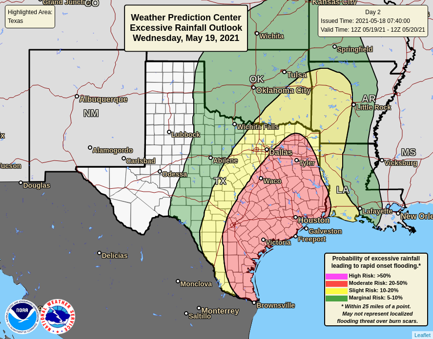
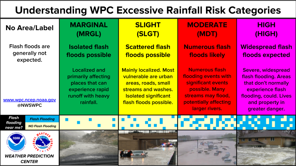
...THERE IS A SLIGHT RISK OF EXCESSIVE RAINFALL FOR PARTS OF THE
CENTRAL UNITED STATES AS WELL AS SOUTH FLORIDA AND THE FLORIDA KEYS...
...Texas to the Great Lakes...
An active day of convection is expected today as a cold front sags
across the Heartland, providing the focus for widespread showers
and thunderstorms. This front will be pushed southeast in response
to an amplifying northern stream trough which will dig across the
CONUS as far south as Texas. This will drive height falls across
the region, with embedded shortwave impulses racing northeast, and
a poleward arcing jet streak downstream of the primary trough axis
combining to provide additional ascent. This deep layer lift will
work into robust thermodynamics characterized by an overlap of
1.8-2.0" PWs (above the 99th percentile per NAEFS) and a ribbon of
MUCAPE exceeding 2000 J/kg (through northern MO), surging northward
on 30-50 kts of 850mb flow emerging on return flow from the Gulf.
The CAMs have continued to be in excellent agreement in the coverage
of convection, while also recently coming into better agreement on
temporal and spatial differences (owing to timing of the front).
CAMs indicate widespread 1"/hr rain rates from the northern TX
Hill Country all the way to the eastern Missouri Valley
(40-km neighborhood 1"/1-hr probabilities exceeding 50% across
this entire area), and these probabilities increase from north to
south overtime today (as overnight convection likely remains active
in the morning, then grows upscale during the day). Although mean
0-6km winds of 20-30 kts indicate progressive storm motions, this
flow aligned to the front and combined with Corfidi vectors that
collapse and veer to the NE indicate a high potential for
redevelopment to the SW into the more intense thermodynamics and
training of cells to the northeast. Where this occurs, localized
rainfall totals exceeding 3" are likely (50-80% 3"/24-hr
neighborhood exceedance probs across the entire Slight risk area,
per 00z HREF). The best spatial agreement for 2"+ totals (per 00z
HREF EAS 2"/24-hr exceedance probs) are located within the core of
the central and northern portions of the Slight risk, from central
OK through southeast KS and central MO (where 5" neighborhood
exceedance probabilities are also greatest, as high as 30-50%). The
inherited SLGT risk was tailored to this new guidance, but very
little change was necessary. The Slight risk over TX is considered
the lowest confidence, as spatial agreement (per HREF EAS probs) is
lowest here (though convection that does manage to develop along
the tail of this front well into the night will likely feature
slow storm motions and backbuilding, with 5" neighborhood
exceedance probabilities still as high as 20-30%).
Although heavy rainfall is also likely in convection that develops
northeast into the Upper Midwest and Great Lakes, storms should be
more progressive and the Corfidi vectors suggest less opportunity
for training, so only a MRGL risk is maintained north of IA.
...South Florida and the Florida Keys...
A shortwave trough over the Gulf has amplified enough overnight to
become a weak closed low early this morning, and is expected to
spin nearly in place as it gets suppressed beneath a Bermuda- type
ridge to its northeast. This will maintain modest synoptic ascent
across Florida, but some enhancement is likely as a jet streak
over the Atlantic tails back to the SW, placing the favorably
diffluent RRQ overtop the peninsula. This forcing will combine
with continued low-level convergence along a decayed front/surface
trough, resulting in another day of widespread showers and
thunderstorms. PWs in place will again be greater than 2 inches,
above the 90th percentile according to NAEFS, combining with 1000
J/kg of CAPE to produce robust thermodynamics to support rainfall
rates of 2"/hr at times. There continues to be some uncertainty in
the coverage of convection among the various CAMs, but better
agreement in the placement of 3"+ amount (per HREF EAS probs) along
the southwest coast of FL has necessitated an expansion of the SLGT
to just south of Tampa Bay. While FFG exceedance probs are highest
across this area, have also maintained the SLGT for the remainder
of South FL (including all of the FL Keys and the Miami metro) as
localized 5" totals remain possible (with HREF 40-km neighborhood
3"/24-hr exceedance probs of 30-50% in very close proximity).
Although not included in a risk area at this time, some of the
guidance has continued to be a bit more aggressive with a wave of
low pressure developing along an inverted trough aligned to the
east coast of Florida. If this low were to develop a bit more
rapidly or track farther west, some heavy rain could move onshore
the northeast Florida coast before 12Z Wednesday.
...Four Corners...
A MRGL risk was further expanded westward with this cycle, now
encompassing southeastern portions of CA through NV/UT/AZ and the
Four Corners region into the the Central Plains. The guidance has
continues to be more aggressive with showers and thunderstorms
blossoming during the afternoon/evening as forcing intensifies
from broad divergence downstream of a closed low filling and moving
into the Desert Southwest, producing ascent atop a wavering
frontal boundary positioned over the region. This lift will impinge
into favorable thermodynamics with PWs reaching above 0.75 inches
into a bubble of MUCAPE of 750-1000 J/kg. Mean storm motions will
be weak, generally around 5 kts, so with rainfall rates which have
a 10-40% chance of exceeding 1"/hr (per 00z HREF 40-km neighborhood
1"/1-hr exceedance probs), these slow motions could result in
locally as much as 1" of rainfall in a short period of time. If
this occurs over sensitive soils, urban areas, or terrain features,
instances of flash flooding could result.
Churchill/Weiss
Day 1 threat area:
www.wpc.ncep.noaa.gov/qpf/94epoints.txt
Excessive Rainfall Discussion
NWS Weather Prediction Center College Park MD
430 AM EDT Tue Jun 3 2025
Day 2
Valid 12Z Wed Jun 04 2025 - 12Z Thu Jun 05 2025
...THERE IS A MARGINAL RISK OF EXCESSIVE RAINFALL FOR PORTIONS OF
THE UPPER MIDWEST, MIDDLE MISSISSIPPI VALLEY, SOUTHERN PLAINS, THE
FOUR CORNERS, AND THE SOUTHEAST COAST...
...Four Corners into Central/Southern High Plains...
Another active day of showers and thunderstorms expected as the
upper low over northern Baja fills and ejects northeast atop the
Four Corners. The accompanying ascent will move into continued
anomalous PWs which will exceed the 99th percentile (per NAEFS).
This will fuel widespread convection capable of localized rainfall
rates of 0.5"/hr (or at times higher). Storms will likely move
slowly beneath the upper trough, leading to a longer duration of
heavy rain. Although total rainfall will be modest in most areas
(as reflected by relatively low 24-hr probability from ECENS/GEFS
for 1" exceedance), where the heavy rain impacts sensitive terrain
features or urban areas instances of flash flooding could result.
Probabilities have also increased a bit (particularly from the new
00z ECENS suite) further east into the Central/Southern High
Plains and the MRGL risk has been expanded accordingly. Should
models come into better agreement, additional expansion may be
needed further south into West TX (and with additional CAM guidance
and agreement, an upgrade to SLGT may also be needed).
...Southern Plains and Mid-Mississippi Valley to Great Lakes...
The cold front from D1 will continue its trek eastward on
Wednesday, but will start to slow and become aligned more west to
east as its tail gets pulled northward by an approaching shortwave
over the Four Corners region. Shortwaves embedded within the flow
will continue to race northeast, especially from Missouri to
Michigan, which is where the greatest concentration of
thunderstorms is expected on D2 (though some models are also
indicated potential for isolated convective development farther
southwest into portions of the Southern Plains). Storm motions
along the front are likely to be progressive, lifting off to the
northeast on 0-6km mean winds of 20-30 kts, but weaker Corfidi
vectors aligned both to this mean wind and the front suggests a
potential for training. As rainfall rates peak above 1"/hr within
favorable thermodynamics, this could result in stripes of heavy
rainfall with ensembles indicating 10-40% chance of exceeding 1"
and up to 10% probabilities for exceeding 2" (with the new ECENS
being the most aggressive). The inherited MRGL risk was maintained
(and expanded a bit southwest) with this update.
...Southeast Coast...
Guidance continues to be somewhat aggressive with a wave of low
pressure potentially developing along an inverted trough shifting
northeast along the FL/GA/SC coasts. While NHC continues to
indicate a 10% probability of tropical or sub-tropical development
with this feature, regardless of whether a circulation forms or
not, there continues to be increasing confidence that heavy rain
will spread across the FL Peninsula and then rotate onshore the
GA/SC coasts on Wednesday. There also has been a clear model trend
of potential increased convective development farther inland to
the FL Panhandle and into southeast AL and southwest GA (likely
due to a stronger closed low and the associated dynamics), so the
MRGL was expanded to reflect this. With PWs progged to exceed 2",
above the 90th percentile, supported by warm cloud depths that may
exceed 15,000 ft, efficient rainfall rates of 1-2"/hr will be
likely in any showers/thunderstorms. It certainly remains possible
that the heaviest rainfall in association with the potential
surface low will remain just offshore, but impressive moisture
convergence from Jacksonville, FL to Charleston, SC should support
waves of heavy rainfall regardless of development of this system.
Additionally, plentiful tropical moisture across the rest of the FL
Peninsula and a shortwave continuing to pivot across the Gulf
could enhance rainfall over much of Florida Wednesday, and the MRGL
was maintained accordingly (with the exception of the FL Keys,
which were removed due to model consensus that convection will be
pulling away northward by 12z Weds).
Churchill/Weiss
Day 2 threat area:
www.wpc.ncep.noaa.gov/qpf/98epoints.txt
Excessive Rainfall Discussion
NWS Weather Prediction Center College Park MD
430 AM EDT Tue Jun 3 2025
Day 3
Valid 12Z Thu Jun 05 2025 - 12Z Fri Jun 06 2025
...THERE IS A SLIGHT RISK OF EXCESSIVE RAINFALL FOR PORTIONS OF
SOUTHERN KANSAS AND NORTHERN OKLAHOMA...
...Central/Southern Plains into the Midwest...
Modest return flow from the Gulf overnight on D2 looks to result in
elevated PWs once again into the Southern Plains by D3, as DPVA in
association with the aforementioned upper-low (now shortwave) may
help to spur more significant convective organization and growth.
While models are still in rather substantial disagreement on the
scale of organization and ultimate placement of higher QPF amounts,
there's enough agreement to reintroduce a SLGT to portions of
KS/OK (where ECENS best overlaps the stronger GEFS signal).
Downscaled GFS and ECMWF solutions suggest the potential for
localized 2-3" totals (as do the respective ensemble exceedance
probs).
...Southeast/Southern Mid-Atlantic Coast...
Guidance continues to indicate the potential for further
development of the aforementioned wave of low pressure. Regardless
of any tropical or sub-tropical development of this feature, heavy
rainfall is likely to remain in close proximity to the coast into
D3. The MRGL was expanded a bit to cover the range of solutions
from the models at this juncture.
Churchill
Day 3 threat area:
www.wpc.ncep.noaa.gov/qpf/99epoints.txt
Extended Forecast Discussion
NWS Weather Prediction Center College Park MD
255 AM EDT Tue Jun 3 2025
The National Hurricane Center is monitoring the potential
development
of a sub- tropical feature off the Southeast Coast. Deepest
moisture may stay offshore and uncertainty is high, but there is a
chance of some heavier rainfall along the coast. WPC maintained the
Marginal Risk of excessive rainfall Thursday into Friday from far
northern Florida up through the coastal Carolinas as the low lifts
slowly up the coast in warm and moist Gulf Stream waters.
Meanwhile, numerous showers and thunderstorms are expected to fire
along a slow-moving and wavy front that will stretch from the
Northeast and Ohio Valley states down to the Southern Plains.
Abundant moisture pooled over the region along with a steady
influx from the Gulf coupled with shortwave/jet support will help
prime the environment for embedded heavy rain potential. This
environment may be conducive for isolated areas with accumulations
of several inches, but local focus details are proving quite
varied in guidance from run to run. WPC has a broad Marginal Risk
spanning from the Plains to the Great Lakes/Northeast through
Sunday morning. Within the Marginal is a smaller area highlighted
with a Slight Risk of excessive rainfall mainly over Oklahoma but
also into the adjacent counties of Arkansas and southwest Missouri.
The southern trailing tail of the elongated boundary will stall
over the southern Plains, eventually with baroclinicity rejuvenated
more broadly again over the central U.S. by ample northern stream
system reinforcement that may also act to spread main heavy
rainfall focus across the Mid- South and Tennessee Valley.
Meanwhile, enhanced rain and thunderstorms will also spread across
the Northeast late week and the weekend as the northern portion of
the front advances, eventually shifting southward through the Mid-
Atlantic toward the Southeast later weekend into next Monday.
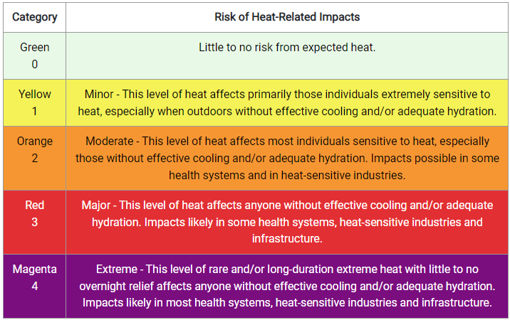
Temperatures will begin moderating on the backside of the cold
front. Some of the warmest year to date temperatures will be
across much of the Eastern U.S. With daily readings climbing into
the upper 80s to lower 90s there will be a Moderate level of
HeatRisk. Care should be taken to protect yourself from the hottest
part of the day. Areas of south Texas will see rising temperatures
through the late week into the weekend, cresting 105F by next
weekend along the Rio Grande. This may push heat index values over
110F.
Heat Safety -- take precautions such as increased water intake and
more time in air conditioned areas to avoid heat exhaustion and
heat stroke. See weather.gov/heat for more information on safety
tips and resources.
Campbell/Schichtel
