Excessive Rainfall Discussion
NWS Weather Prediction Center College Park MD
1120 AM EDT Sat Jun 7 2025
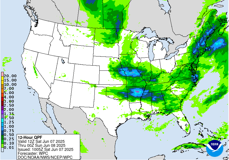
Day 1
Valid 16Z Sat Jun 07 2025 - 12Z Sun Jun 08 2025
...THERE IS A RISK OF EXCESSIVE RAINFALL ACROSS MUCH OF THE EASTERN
UNITED STATES...WITH SLIGHT RISKS IN SOUTHERN NEW ENGLAND... THE
OHIO RIVER VALLEY...AND MID-SOUTH...
An active day of heavy rainfall and flash flooding is expected
across a large portion of the eastern United States, with the
Marginal Risk area now encompassing the majority of the land area
in the CONUS east of 95W longitude. This is due to a broad region
of near to above normal tropospheric moisture (via PW anomalies)
and sufficient instability for convective rain bands and
thunderstorms.
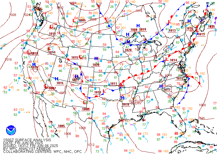
Generally, the broad zone of heavy rainfall risk can be divided
into three main areas of concern, all indicated by a regional-scale
Slight Risk maximum now:
1. In the Northeast, where low-topped convection has organized into
narrow bands of efficient heavy rainfall. MRMS analysis indicates
almost no ice present in these convective bands, with 30 dBZ echo
tops generally shy of the -10C level. In other words, warm rain
processes are dominant and any organized convective rain band could
produce localized heavy rainfall. The area of greatest concern is
probably from active area of flash flooding in the Hudson Valley
near Albany, NY eastward through Massachusetts and northern
Connecticut to the Boston metro area. There should naturally be
increasing low-level convergence with the existing front draped
across the region, and increasing easterly flow near the coast
around the north side of the offshore low. Aloft, a coupled jet
structure should lead to enough divergence to focus convection.
2. The Ohio River Valley region, particularly the middle and upper
Ohio Valley from late this afternoon well into the overnight hours.
This will be due to scattered convective rain bands and perhaps
some thunderstorms developing in advance of an eastward propagating
mid-upper level wave, and developing surface low by this afternoon,
currently centered over IA- MO. This should allow for some
organized convective bands in the warm air advection regime. Model
forecast soundings show increasing PWs to near or above the 90th
percentile for early June and tall, skinny CAPE profiles that are a
good match for efficient, low-topped convective flash flood events.
Of particular concern will be the potential for flash flooding
overnight in the central Appalachian region from eastern Kentucky
and southeast Ohio into West Virginia and southwest Pennsylvania.
Models show southwest low-level inflow increasing into the
mountains in a very moist environment, with the right entrance
region of an upper level jet streak providing divergence aloft. All
of this should support an organized heavy rain threat and the
structure of the instability profile will keep convection low-
topped and dominated by warm rain processes. Locally significant
flash flooding will be possible given the terrain in the area and
relatively wet antecedent conditions.
3. Across the mid-South where a forward propagating MCS has already
generated some flash flooding in central Arkansas, but appears to
begin accelerating. Renewed development and/or stalling and
training will be possible along the southern periphery of the cold
pool later today, and hi-res models do show localized corridors of
heavy rainfall that would be sufficient to cause flash flooding.
The Slight Risk was shifted south to account for observational
trends indicating the current position of the cold pool and
convective line, and the projected motion over the next few
hours.
Lamers
Day 1 threat area:
www.wpc.ncep.noaa.gov/qpf/94epoints.txt
Excessive Rainfall Discussion
NWS Weather Prediction Center College Park MD
1120 AM EDT Sat Jun 7 2025
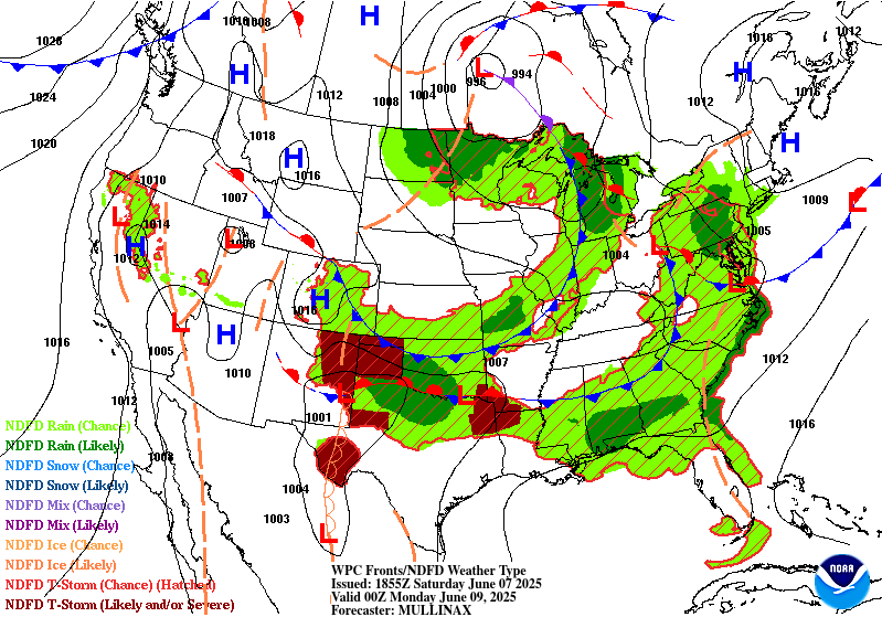
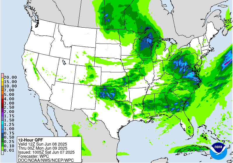
Day 2
Valid 12Z Sun Jun 08 2025 - 12Z Mon Jun 09 2025
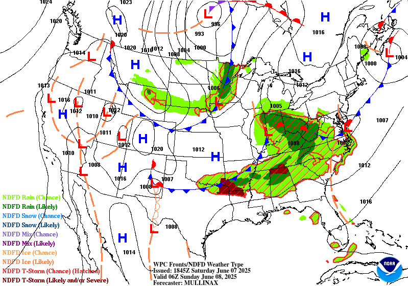
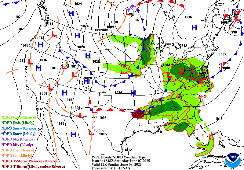
...THERE IS A SLIGHT RISK OF EXCESSIVE RAINFALL ACROSS NORTHERN
TEXAS AND SOUTHERN OKLAHOMA...
...Southern Plains to the Southeast...
The latest guidance remains consistent in showing additional
shortwave energy pushing east southeastward late Sunday
afternoon/evening from the lee of the Central to Southern Rockies
into the Southern Plains in the northwest flow on the south side
of a stronger upper level low centered over the north-central
United States. This will again re-strengthen the low level flow
into the west to east oriented front forecast to remain across the
Southern Plains, supporting another round of organized convection
along the front. There continues to be fairly good agreement on
the potential for an axes of heavy precip day 2, resulting in good
continuity with the slight risk area with only some small changes
to reflect the latest forecasts. This next round of organized
convection will likely be fairly progressive, similar to what
occurred farther to the north Thursday night into early Friday and
Friday night into early Saturday. Still, there is likelihood of
widespread rainfall amounts of 1-2" with localized amounts up to
4". Soils are not as saturated as areas farther north, but
localized runoff issues are still likely.
...Central Appalachians into the Mid-Atlantic...
The negatively tilted shortwave coming out of the OH Valley late
day 1 will push across the Central Appalachians into the Mid-
Atlantic day 2. There is a fair amount of spread with model qpfs,
but a signal for the potential for locally heavy rains in the
continued well defined area of upper difluence ahead of these
height falls in an axis of above average PW values...1.5 to 2+
standard deviations above the mean. There were only some minor
changes made to the previous marginal risk across the Central
Appalachians into the Mid- Atlantic, continuing to center it across
areas that have lower ffg values.
Oravec
Day 2 threat area:
www.wpc.ncep.noaa.gov/qpf/98epoints.txt
Excessive Rainfall Discussion
NWS Weather Prediction Center College Park MD
1120 AM EDT Sat Jun 7 2025
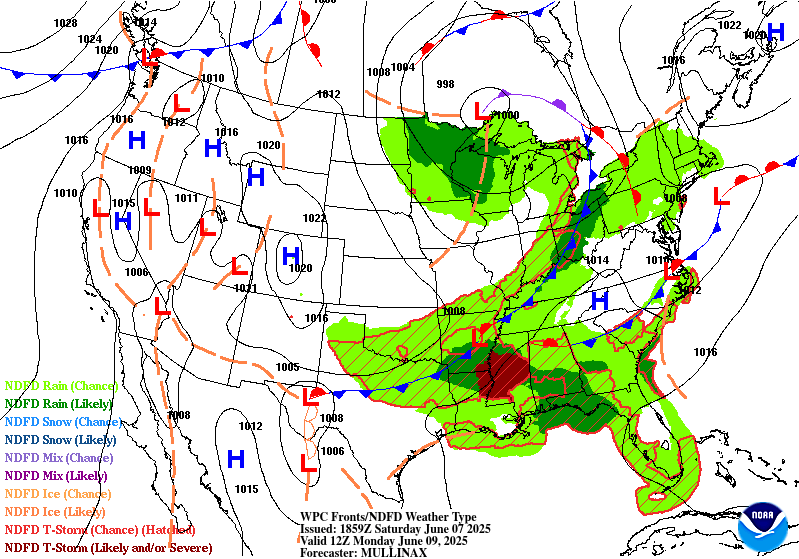
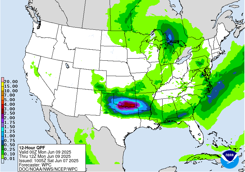
Day 3
Valid 12Z Mon Jun 09 2025 - 12Z Tue Jun 10 2025
...THERE IS A MARGINAL OF EXCESSIVE RAINFALL ACROSS THE SOUTHERN
PLAINS, LOWER MISSISSIPPI VALLEY, NORTHEAST THROUGH THE TENNESSEE
VALLEY, UPPER OHIO VALLEY AND INTO THE EASTERN GREAT LAKES...
There is good agreement in the latest guidance with the slow
eastward push of the closed low through the Upper Lakes day 3 and
the broad upper troffing extending south of this center through the
MS and OH Valleys. A broad region of above average PW values will
continue to stretch across the southern tier from the Southern
Plains, east across the Lower MS Valley and into the Southeast
along and ahead of the lead west to east oriented front. Another
axis of above average PW values will push northeastward across the
TN and OH Valleys into the Lower Lakes ahead of a secondary front
rotating through the cyclonic flow on the southeast side of the
strong closed low over the Upper Lakes. Along each frontal
boundary, widespread moderate to locally heavy precip totals are
likely. Model agreement, however, is not great with placement of
maximum amounts, leading to overall low confidence in where
anything but a marginal risk could be drawn. Overall, the previous
broad marginal risk area fits well with the latest model qpf
spread, with no significant changes made to previous outlook for
the new day 3 outlook.
Oravec
Day 3 threat area:
www.wpc.ncep.noaa.gov/qpf/99epoints.txt
Extended Forecast Discussion
NWS Weather Prediction Center College Park MD
214 AM EDT Sat Jun 7 2025
A trailing frontal boundary draped generally west to east across
the South will provide focus for numerous showers and thunderstorms
through much of next week. The Days 4 and 5 Excessive Rainfall
Outlooks (valid Tuesday and Wednesday) reflect this. For Day 4, a
very broad marginal risk stretches all the way from the southern
Plains/High Plains to the Gulf Coast states. Models are starting to
show better consensus on potentially flooding rains impacting
central Texas, but still with enough uncertainty to preclude a
slight risk at this time. For Day 5, there is better agreement on
heavy to excessive rainfall again in central Texas, and combined
with rainfall in the same region on Day 4, went ahead and added a
slight risk to the ERO for tonight. By Thursday, this boundary
looks to lift northward with heavy rainfall potential moving into
the central Plains/mid-Mississippi Valley which has been wet as of
late and will need to be monitored for flooding concerns later this
week.
The northern portion of this boundary should be quicker to move
through the East, but heavy rainfall is possible along the boundary
amidst ample moisture and instability and favorable upper level
dynamics. A marginal risk for the interior Northeast remains on the
Day 4 ERO. Elsewhere, additional short wave energy interacting
with a frontal boundary across the northern tier will bring showers
and storms from parts of the northern Rockies into the Upper
Midwest. Marginal risk areas were added to the Day 5/Wednesday ERO
tonight for parts of Montana and also South
Dakota/Minnesota/Wisconsin.
Much above normal temperatures will continue into early next week
for the Northwest, with anomalies of +20-25F likely to continue on
Tuesday. This should equate to a moderate to major HeatRisk for
parts of this region along with widespread record highs.
Temperatures and HeatRisk should by Wednesday, but remain slightly
above normal, including farther south into the central Great Basin.
Short range heat across South Texas should be much less extreme by
Tuesday as an upper level shortwave moves into the region. By next
Thursday-Saturday, most of the country will be near or within a
few degrees of normal.
Santorelli


