Excessive Rainfall Discussion
NWS Weather Prediction Center College Park MD
349 PM EDT Sun Jun 8 2025
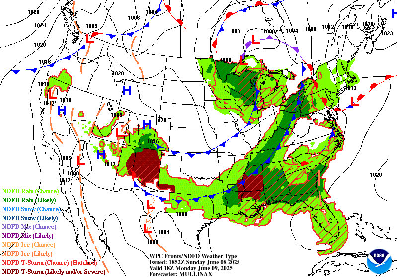
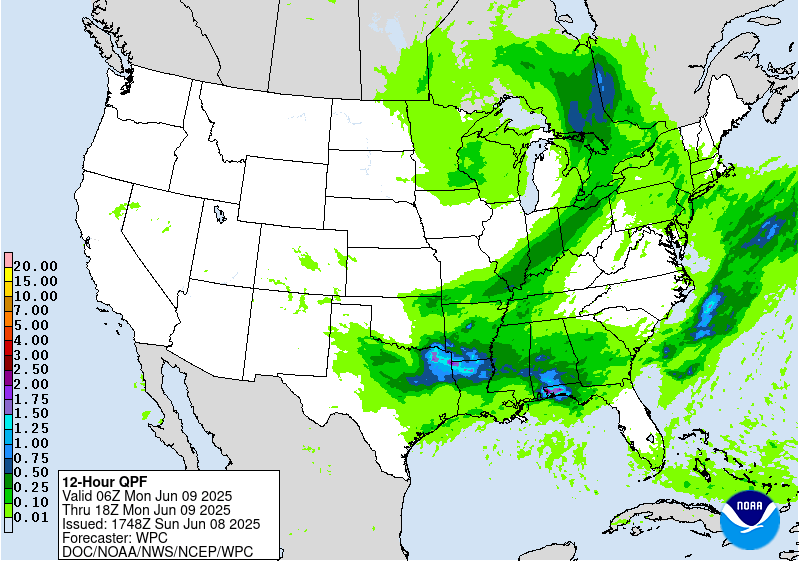
Day 1
Valid 16Z Sun Jun 08 2025 - 12Z Mon Jun 09 2025
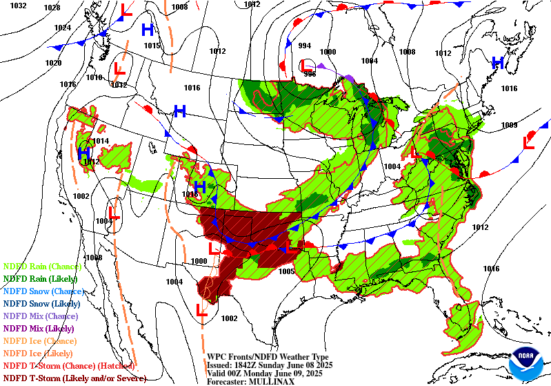
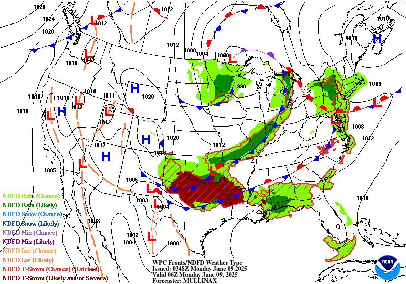
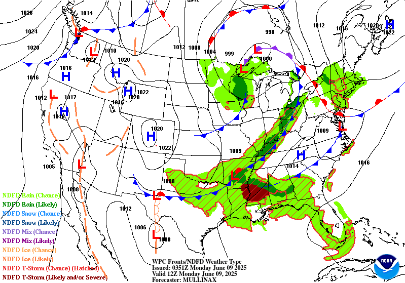
...THERE IS A SLIGHT RISK OF EXCESSIVE RAINFALL FOR PORTIONS OF THE
SOUTHERN PLAINS...GULF COAST...AND MID-ATLANTIC...
...Mid-Atlantic and Central Appalachians...
Very few changes were made to the existing Day 1 outlook over this
region, with observational trends generally matching earlier
forecasts fairly well. The initial round of rain has moved through
much of the Slight Risk area as of 15 UTC, and has produced a
fairly widespread 0.5 to 1.0 inches of rain in much of the area. As
cloud cover partially clears in the wake of the area of stratiform
rain, rapid destabilization is occurring, and this is already
beginning to support convective initiation. Although the PWs may be
slightly lower in this area of clearing, they are still relatively
high (around 1.4 to 1.5 inches) around the 90th percentile for
early June. The combination of the increasingly strong instability
and relatively deep moisture should support hourly rain rates of 1
to 2 inches per hour in the most vigorous and organized convection.
This may lead to flash flooding, particularly in situations where
the rain rates can be sustained for more than an hour, and either
in the mountainous areas of N WV, W MD, SW PA that have been very
wet lately, or in urbanized areas in the coastal plain.
...Gulf Coast...
Training and backbuilding thunderstorm activity has been far more
persistent this morning in portions of E MS and C AL than models
have been indicating. However, 12 UTC hi-res guidance appears to
generally have a better handle on the current mesoscale environment
and state of the convection. There is good agreement that the
convective line itself and/or the associated gust front will make
steady progress toward the coast today, and then begin to stall
later this afternoon or early tonight. This may focus additional
convective clusters and lines later today and tonight, with a
favorable configuration for backbuilding (southwesterly inflow with
an upstream reservoir of strong instability). The combination of
the very high CAPE values, and anomalously high PWs around 2
inches, will support very heavy hourly rain rates approaching or
exceeding 2 inches in the most organized convective clusters. If
the gust front interacts with the coastal convergence zone and
anchors convection somewhere near the coastline, heavy rain rates
could persist for several hours and lead to a locally extreme
rainfall event with potential for significant flash flooding.
...Southern Plains...
The heavy rainfall and associated flash flooding threat in this
region is more conditional, given excellent hi-res model agreement
in a very organized, rapidly forward propagating bowing line late
this afternoon and this evening. Although the instantaneous rain
rates in the line itself would be likely to be high, the fast
forward speed would likely mitigate that factor a bit. Corridors of
heavy rainfall in these cases tend to occur either:
1. Near the poleward bookend vortex, which can tend to move slower
and still have relatively high rain rates. In this case, that would
be most likely over portions of SC OK, although the fast forward
motion of the line makes it uncertain how impactful this would be
from a rainfall perspective.
2. Or along the upshear flank of the cold pool. That seems
plausible in this case, and would be most likely either in far
SW OK or in western N TX. In particular, a corridor of locally
heavy rainfall and flash flooding would seem more likely if
convective development occurs near a lingering front in advance of
the main forward propagating MCS, thereby increasing the duration
of the heavy rainfall. However, it's unclear whether this
antecedent development and the eventual gust front location will be
co-located.
Therefore, the Slight Risk was maintained given these
uncertainties, and was only nudged slightly to the southwest to
account for latest observational data trends and hi-res guidance.
Lamers
Day 1 threat area:
www.wpc.ncep.noaa.gov/qpf/94epoints.txt
Excessive Rainfall Discussion
NWS Weather Prediction Center College Park MD
349 PM EDT Sun Jun 8 2025
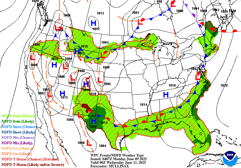
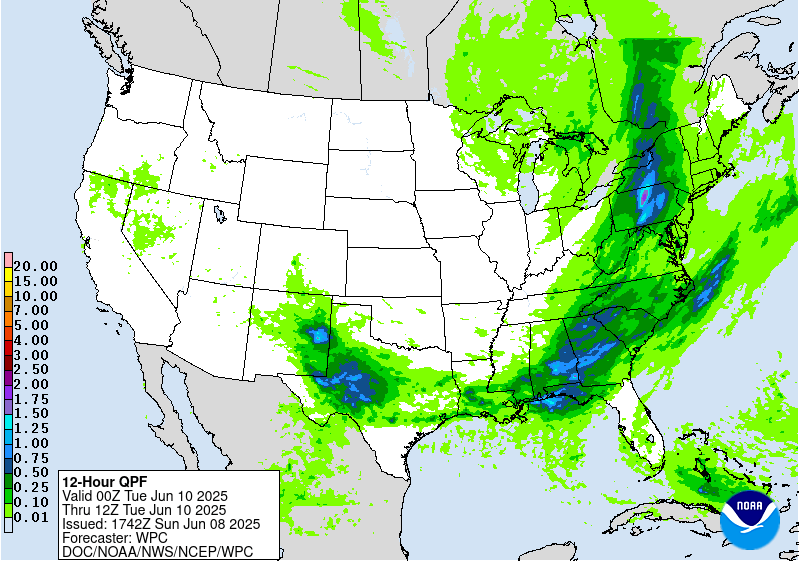
Day 2
Valid 12Z Mon Jun 09 2025 - 12Z Tue Jun 10 2025
...THERE IS A SLIGHT RISK OF EXCESSIVE RAINFALL IN PORTIONS OF
PENNSYLVANIA AND NEW YORK...AS WELL AS THE GULF COAST...
...Northeast and Ohio Valley...
Convective lines are expected to develop Monday just ahead of a
strong, steadily advancing cold front over the eastern Great Lakes
and Ohio Valley, and eventually advancing into the interior
Northeast (PA and NY in particular). A narrow plume of PWs around
1.5 inches and moderate instability should support heavy rain rates
on the order of 1-2 inches per hour in the most intense activity.
The Slight Risk was maintained but retracted a bit to be focused
primarily in Pennsylvania and southern New York. The model QPF
signal was reduced a bit in eastern Ohio and West Virginia. Greater
confidence in the possibility of training thunderstorms or
convective rain bands exists over PA and NY where the deep layer
mean wind will be more parallel to the cold front orientation.
Further southwest into portions of SE OH, WV, KY, TN, the HREF and
experimental RRFS ensemble both show a scattering of low chances of
rainfall exceeding flash flood guidance on a 1-hr or 3-hr basis,
but overall ensemble mean QPF is lower and the mean wind is more
crosswise to the cold front. This suggests convective lines should
be more progressive and any flash flooding impacts may be more
isolated.
...Gulf Coast and Southeast...
A Slight Risk was introduced from SE MS into S AL, SW and C GA, and
the FL Panhandle. Multi-model ensemble QPFs show the greatest
chances of 2+ inches of rainfall now increasingly concentrated in
this area. Scattered clusters of thunderstorms are expected to
develop by Monday afternoon across the Gulf Coast region in an
environment characterized by strong instability and PWs around 2
inches. The availability of deep moisture and favorable instability
would support very heavy rain rates. While hi-res models differ a
bit on the details, they all generally show clusters and lines of
thunderstorms developing in west-east oriented bands along
mesoscale boundaries. Some of these boundaries may be related to
convection from the day and night prior, or increasingly the
arrival of a synoptic cold front from the northwest. Any lines that
are oriented in this fashion would be more parallel to the deep
layer mean wind and could create corridors of training convection
and swaths of localized heavy rainfall.
...West Texas and New Mexico...
For now, a broad Marginal Risk was maintained in these areas as any
concentrated areas of heavy rainfall would likely be highly
dependent on the convective evolution from Sunday afternoon into
Monday morning across the region. A forward propagating MCS across
S OK and N TX should push an outflow boundary somewhere into C TX,
and that could become a feature that focuses renewed convective
development on Monday. Broad low-level east to southeast flow from
the coastal plain all the way into W TX and E NM should cause PWs
to gradually increase, and support scattered convection well into
C/E NM during the afternoon hours. Some hi-res models show this
activity in NM coalescing into a MCS and pushing southeastward into
W TX during the evening and overnight, and existing boundaries
would be important to that process as well. It's possible a Slight
Risk may be needed in future outlook updates.
Lamers
Day 2 threat area:
www.wpc.ncep.noaa.gov/qpf/98epoints.txt
Excessive Rainfall Discussion
NWS Weather Prediction Center College Park MD
349 PM EDT Sun Jun 8 2025
Day 3
Valid 12Z Tue Jun 10 2025 - 12Z Wed Jun 11 2025
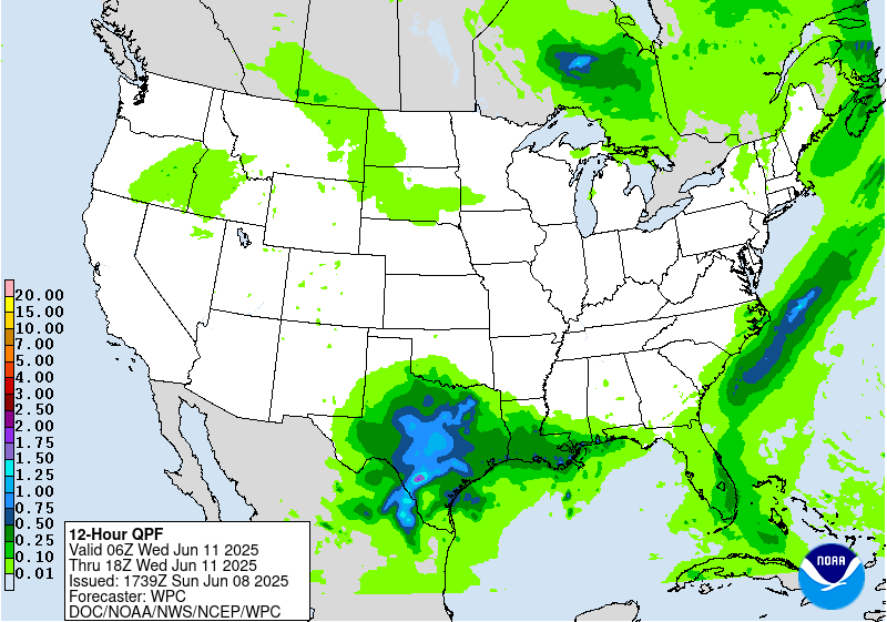
...THERE IS A SLIGHT RISK OF EXCESSIVE RAINFALL FOR MUCH OF WEST
TEXAS AND SOUTHEASTERN NEW MEXICO...
...West Texas, Texas Hill Country, and Southwest New Mexico...
Greater confidence exists in a heavy rainfall event on Tuesday
(compared to Monday) in SE NM and W/C TX. A shortwave ejecting out
of the Desert Southwest will push through NM early Tuesday and
approach the Slight Risk area over the aforementioned region. The
combination of abundant deep moisture, with PWs generally above the
90th percentile for early June, strong instability, the approaching
shortwave, and upper level divergence will favor widespread
thunderstorm activity. Deep layer mean winds will not be
particularly strong, around 10-15 knots, which should favor slow
eastward propagation with time. It seems most likely that
convective initiation will occur closer to the Sacramento,
Guadalupe, and Davis Mountains from SE NM into far W TX, near the
nose of a low-level moisture transport maximum. Slow propagation of
convective clusters could then lead to flash flooding issues from
near those areas, to eventually as far east as the Edwards Plateau
and Texas Hill Country.
Lamers
Day 3 threat area:
www.wpc.ncep.noaa.gov/qpf/99epoints.txt
Extended Forecast Discussion
NWS Weather Prediction Center College Park MD
258 PM EDT Sun Jun 8 2025
A frontal boundary draped generally west to east across the South
will continue to provide focus for numerous showers and
thunderstorms through most of this week. Guidance continues to
converge on Texas and surrounding states as seeing multiple rounds
of heavy rain, with parts of this area (from northern Texas
northward) already primed for flooding with wet antecedent
conditions from recent rainfall. Thus Slight Risks remain in place
for much of Texas and into southern Oklahoma on Day 4 and 5 (valid
Wednesday and Thursday) and inching into the Ark-La-Tex Day 5 as
the primary convection moves slightly eastward. Model trends have
been for more heavy rain on the southern and eastern sides, so
expanded the Slight Risks in this direction on both days. Continue
to keep the risk areas broad given lingering uncertainties in
exactly where possible convective complexes track and the location
of heaviest rain. The relatively higher probabilities of flash
flooding potential may be near/over the I-35 corridor from the
Dallas-Fort Worth Metroplex south to Austin and San Antonio on
Wednesday, while it is harder to tell on Thursday. Moderate Risks
are not out of the question at some point in future cycles.
Moderate to heavy rain may continue to linger in the south-central
U.S. late week into next weekend, possibly exacerbating flooding
issues.
A shortwave interacting with a frontal boundary across the
northern tier will bring showers and storms across parts of the
northern Rockies into the Upper Midwest. Moisture anomalies should
be above the 90th percentile in Montana on Wednesday and spreading
east Thursday, while convection rides along the cusp of the
instability gradient. This supports Marginal Risks on the Wednesday
and Thursday ERO with only minor changes to the previous issuance.
By late week, combining upper level and frontal features will
allow for rainfall spreading into the east-central and eastern
U.S., with a general focus around the middle Mississippi/Ohio
Valleys into the northern Mid-Atlantic, but with ample spread in
the details at this point.
A heat wave early this week over the West should moderate by the
start of the medium range period, though above normal temperatures
may continue across interior parts of the West through the period.
Daytime highs generally could be 10 to 15 degrees above normal.
Otherwise, the rest of the country looks near normal or within a
few degrees of normal depending on quick systems moving through.
Tate/Santorelli


