Excessive Rainfall Discussion
NWS Weather Prediction Center College Park MD
1147 AM EDT Sun Jun 8 2025
Day 1
Valid 16Z Sun Jun 08 2025 - 12Z Mon Jun 09 2025
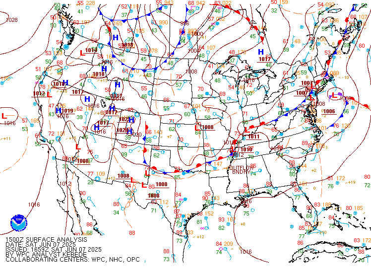
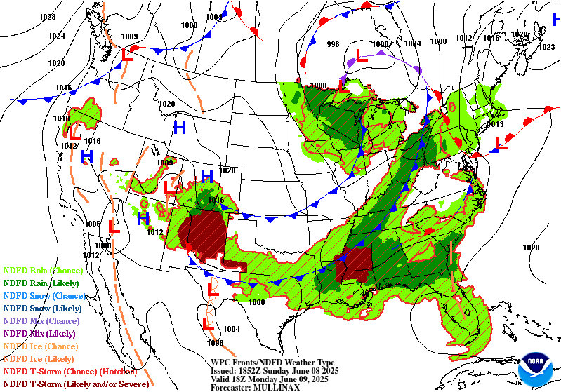
...THERE IS A SLIGHT RISK OF EXCESSIVE RAINFALL FOR PORTIONS OF THE
SOUTHERN PLAINS...GULF COAST...AND MID-ATLANTIC...
...Mid-Atlantic and Central Appalachians...
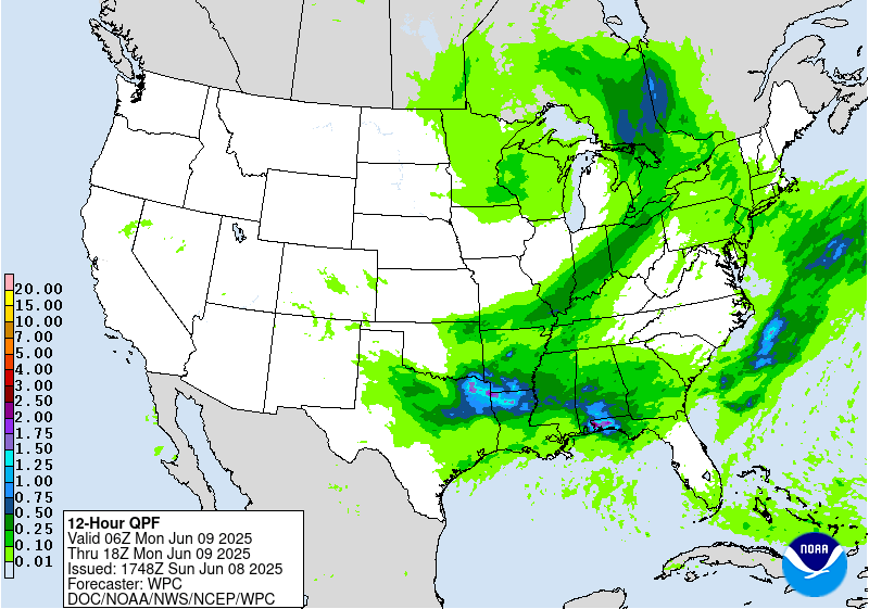
Very few changes were made to the existing Day 1 outlook over this
region, with observational trends generally matching earlier
forecasts fairly well. The initial round of rain has moved through
much of the Slight Risk area as of 15 UTC, and has produced a
fairly widespread 0.5 to 1.0 inches of rain in much of the area. As
cloud cover partially clears in the wake of the area of stratiform
rain, rapid destabilization is occurring, and this is already
beginning to support convective initiation. Although the PWs may be
slightly lower in this area of clearing, they are still relatively
high (around 1.4 to 1.5 inches) around the 90th percentile for
early June. The combination of the increasingly strong instability
and relatively deep moisture should support hourly rain rates of 1
to 2 inches per hour in the most vigorous and organized convection.
This may lead to flash flooding, particularly in situations where
the rain rates can be sustained for more than an hour, and either
in the mountainous areas of N WV, W MD, SW PA that have been very
wet lately, or in urbanized areas in the coastal plain.
...Gulf Coast...
Training and backbuilding thunderstorm activity has been far more
persistent this morning in portions of E MS and C AL than models
have been indicating. However, 12 UTC hi-res guidance appears to
generally have a better handle on the current mesoscale environment
and state of the convection. There is good agreement that the
convective line itself and/or the associated gust front will make
steady progress toward the coast today, and then begin to stall
later this afternoon or early tonight. This may focus additional
convective clusters and lines later today and tonight, with a
favorable configuration for backbuilding (southwesterly inflow with
an upstream reservoir of strong instability). The combination of
the very high CAPE values, and anomalously high PWs around 2
inches, will support very heavy hourly rain rates approaching or
exceeding 2 inches in the most organized convective clusters. If
the gust front interacts with the coastal convergence zone and
anchors convection somewhere near the coastline, heavy rain rates
could persist for several hours and lead to a locally extreme
rainfall event with potential for significant flash flooding.
...Southern Plains...
The heavy rainfall and associated flash flooding threat in this
region is more conditional, given excellent hi-res model agreement
in a very organized, rapidly forward propagating bowing line late
this afternoon and this evening. Although the instantaneous rain
rates in the line itself would be likely to be high, the fast
forward speed would likely mitigate that factor a bit. Corridors of
heavy rainfall in these cases tend to occur either:
1. Near the poleward bookend vortex, which can tend to move slower
and still have relatively high rain rates. In this case, that would
be most likely over portions of SC OK, although the fast forward
motion of the line makes it uncertain how impactful this would be
from a rainfall perspective.
2. Or along the upshear flank of the cold pool. That seems
plausible in this case, and would be most likely either in far
SW OK or in western N TX. In particular, a corridor of locally
heavy rainfall and flash flooding would seem more likely if
convective development occurs near a lingering front in advance of
the main forward propagating MCS, thereby increasing the duration
of the heavy rainfall. However, it's unclear whether this
antecedent development and the eventual gust front location will be
co-located.
Therefore, the Slight Risk was maintained given these
uncertainties, and was only nudged slightly to the southwest to
account for latest observational data trends and hi-res guidance.
Lamers
Day 1 threat area:
www.wpc.ncep.noaa.gov/qpf/94epoints.txt
Excessive Rainfall Discussion
NWS Weather Prediction Center College Park MD
1147 AM EDT Sun Jun 8 2025
Day 2
Valid 12Z Mon Jun 09 2025 - 12Z Tue Jun 10 2025
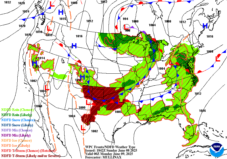
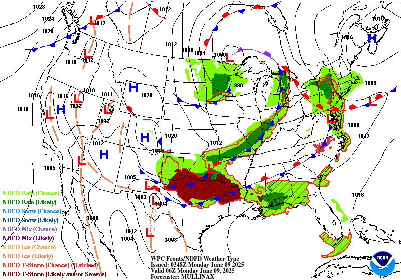
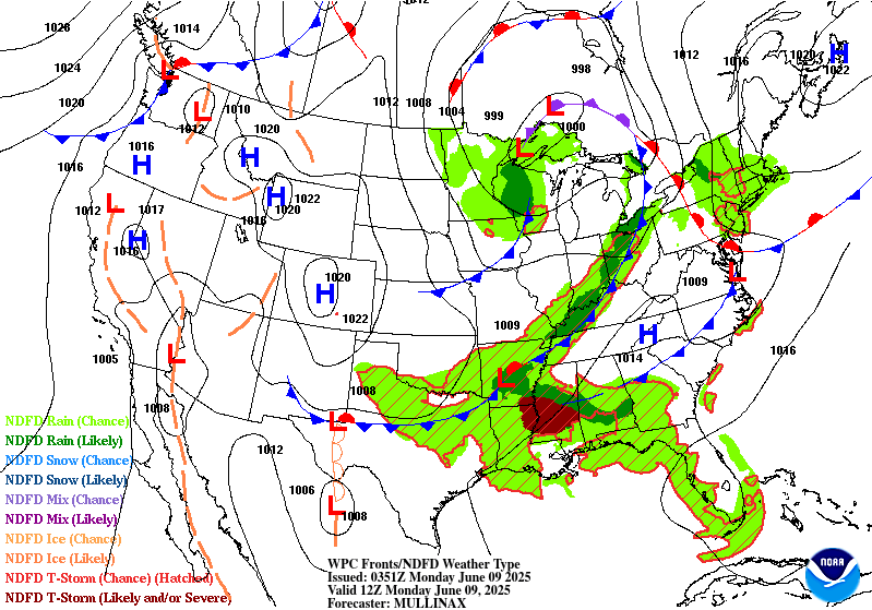
...THERE IS A SLIGHT RISK OF EXCESSIVE RAINFALL FOR THE UPPER OHIO
VALLEY THROUGH CENTRAL NEW YORK...
...Upper Ohio Valley through Central New York...
A potent upper level low over the Great Lakes on Monday will become
increasingly negatively tilted through the period as a shortwave
and the low itself begin the process of rejoining the jet stream.
Thus, expect the upper low and any flow around it over the
Northeast to become more southwesterly with time. At the surface, a
strong cold front will rapidly sweep across the Midwest. That front
will be slower-moving in northern areas as the upper level pattern
becomes more amplified. Thus, the storms that will develop ahead of
the cold front will be slower moving from Pennsylvania north into
New York, supporting a higher likelihood for training. Ahead of
this cold front, Gulf moisture will be drawn northeastward,
supported by the increasing upper level forcing as the trough
becomes more negatively tilted by Monday evening.
Longer-range CAMs guidance shows multiple rounds of storms tracking
across Pennsylvania and New York through the period, being driven
by different impulses of upper level energy as those shortwave
troughs track more south to north with time. While duration of the
heavier rains will be lesser on Monday across WV, MD, and VA,
expected heavy rainfall from the Day 1/Sunday period in this area
should lower the FFGs in the area by the Day 2/Monday period. Thus,
the Slight Risk includes areas expecting less rainfall on Monday
afternoon. Meanwhile in PA and NY, sensitive soils will still be
present, as well as topographic concerns, so the higher threat for
flash flooding will be into western and central NY.
...Southeast...
Across the Southeast, expect multiple rounds of storms to cross
Mississippi, Alabama, and Georgia through the period. The storms
will be supported by periodic passages of shortwave disturbances in
the upper levels, but they will be much further in between
disturbances as compared with areas further north, as the Southeast
will be further from the greatest forcing associated with the low
over the Great Lakes. Partially offsetting this will be the
proximity to the Gulf, which will allow for there to be far more
moisture available for the storms as compared with areas further
north. Soils in this area are around average for moisture content
as there has been some time for the soils to dry out from past
rainfall events. This has allowed FFGs to recover quite a bit, and
the high FFGs will play a big role at tampering the severity and
frequency of instances of flash flooding due to the heavy rains.
Thus, for now, the area remains in a Marginal risk, but will be
evaluated with future updates for upgrade potential.
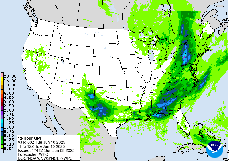
...Texas...
Significant uncertainty remains in the potential for flash flooding
across Texas on Monday. The cold front impacting much of north
Texas on Sunday will push further south, turning the predominant
flow out of the north across the northern half of the state. This
should allow for advection of drier air. Ample solar heating will
still promote the development of instability, as well as any
evapotranspiration in the area. Thus, expect at least some shower
and thunderstorm activity again on Monday, albeit more likely on
Monday night. Given the sensitivities from heavy rains in this
area, the lesser coverage and duration of storms may still be
enough to eventually need a targeted Slight Risk upgrade between
now and Monday afternoon, but the confidence is not quite there
yet.
Wegman
Day 2 threat area:
www.wpc.ncep.noaa.gov/qpf/98epoints.txt
Excessive Rainfall Discussion
NWS Weather Prediction Center College Park MD
1147 AM EDT Sun Jun 8 2025
Day 3
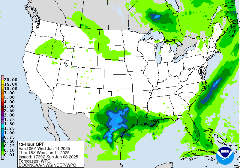
Valid 12Z Tue Jun 10 2025 - 12Z Wed Jun 11 2025
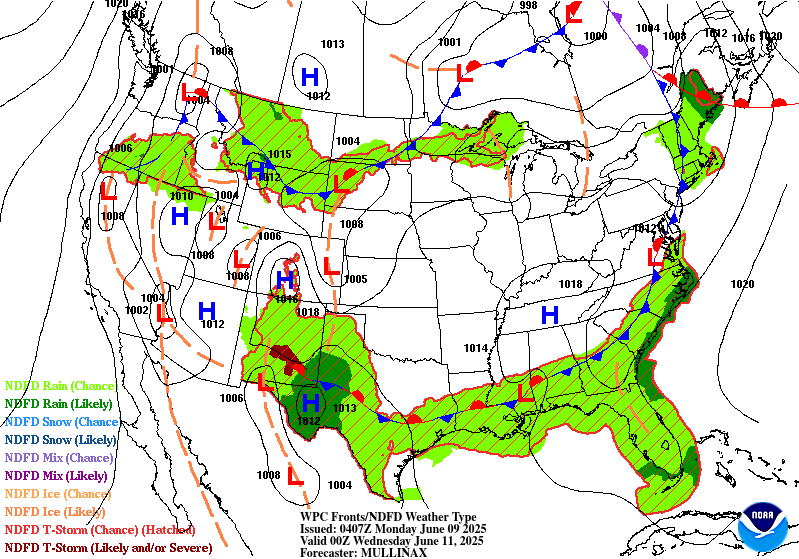
...THERE IS A SLIGHT RISK OF EXCESSIVE RAINFALL FOR MUCH OF WEST
TEXAS AND SOUTHEASTERN NEW MEXICO...
...West Texas and New Mexico...
After potentially leftover convection in the early morning hours of
Tuesday from Monday night's convection, much of the day across the
Slight Risk area will be mostly dry. With peak solar heating in the
late afternoon, however, a strengthening subtropical shortwave
ejecting out of the Southwest will interact with the plentiful Gulf
moisture already in place across west Texas. This will result in
widespread convective development Tuesday evening. There is
significant uncertainty however with the nature, coverage, and
strength of the thunderstorms, as well as where and when they will
impact any one area. Given that, and the spread in the guidance,
the Slight Risk was expanded westward into New Mexico to account
for potential development off the Sacramento Mountains, and any dry
line convection. Regardless, there remains enough agreement that
given plentiful recent rainfall and convective activity across West
Texas, this new round of rain should result in widely scattered
instances of flash flooding. This may be start of another period of
daily thunderstorms in this area through the mid-range.
...New England...
Convective activity in this region will be ongoing at the start of
the period and continue through the day as Atlantic moisture is
drawn northward ahead of a NNE moving upper level trough that will
be rejoining the jet stream. The rainfall should be largely over in
New England by Tuesday evening. Given most of the day the rainfall
will be in the cooler, more stable part of the day, expect lesser
rainfall rates. Thus, the inherited Marginal Risk was left
unchanged with this update.
Wegman
Day 3 threat area:
www.wpc.ncep.noaa.gov/qpf/99epoints.txt
Extended Forecast Discussion
NWS Weather Prediction Center College Park MD
226 AM EDT Sun Jun 8 2025
A trailing frontal boundary draped generally west to east across
the South will continue to provide focus for numerous showers and
thunderstorms through most of next week. Guidance continues to
converge of central Texas into Oklahoma for multiple days of heavy
rainfall, with parts of this area already primed from recent
rainfall. Accordingly, the Days 4 and 5 Excessive Rainfall Outlooks
(valid Wednesday and Thursday) show slight risk areas across this
region. Intentionally kept the slight risks (and surrounding
marginal risks) broad given some lingering uncertainties in exactly
where possible convective complexes track and the location of
heaviest rain. If the forecast materializes though, it is possible
a moderate risk area may be needed at some point in the future. By
Thursday and Friday, this front should lift north pulling the
heavier rains out of Texas, but continuing for parts of Oklahoma
into the middle Mississippi Valley, eventually moving into the Ohio
Valley and East next weekend.
A shortwave interacting with a frontal boundary across the
northern tier will bring showers and storms across parts of the
northern Rockies into the Upper Midwest. Moisture anomalies should
be above the 90th percentile in especially Montana, supporting a
Marginal Risk on the Wednesday and Thursday ERO. Additionally,
convection is likely to move through the north- central U.S. along
the cusp of the instability gradient and thus the Marginal Risk
also extends east into the Upper Midwest.
A heat wave during the short range period over the West should
moderate by the start of the medium range period, though above
normal temperatures may continue across the West through the
period. Daytime highs generally could be 5 to locally 15 degrees
above normal. Otherwise, the rest of the country looks near normal
or within a few degrees of normal depending on quick systems moving
through.
Santorelli


