Excessive Rainfall Discussion
NWS Weather Prediction Center College Park MD
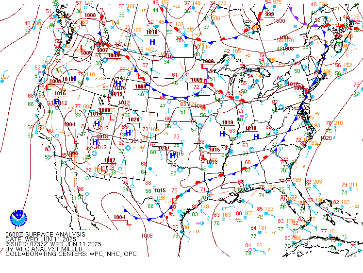
838 PM EDT Wed Jun 11 2025
Day 1
Valid 01Z Thu Jun 12 2025 - 12Z Thu Jun 12 2025
...THERE IS A MODERATE RISK OF EXCESSIVE RAINFALL FOR PORTIONS OF
CENTRAL TEXAS...
...Texas...
23Z Update: Tweaks were made to the outlook areas based on late
afternoon observational trends, but mostly due to the recent trends
in the guidance -- in particular the recent HRRR/RRFS as well as
the 18Z HREF. This resulted in a subtle southward shift in both the
Moderate and Slight Risk areas across portions of South and South-
Central TX, with the Moderate Risk area now encompassing both the
Austin and San Antonio metro areas.
Across the Moderate Risk area, increasing large-scale ascent
overnight ahead of the slow-moving upper shortwave along with a
favorable thermodynamic profile (PWs aoa 2" and MUCAPEs 1500-2000
J/Kg) will make for highly efficient warm rain processes within a
ribbon of strong low-level moisture transport (+2 to 2.5 standard
deviations above normal). Meanwhile, easterly QLCS progression will
likely retard somewhat overnight as per the shrinking Corfidi
Vectors, as the LLJ increases and veers, aligning nearly parallel
and approaching the same magnitude of the mean 850-300 mb flow.
This will enhance the risk of cell training, which is expected to
maximize within the Moderate Risk area.
Per the latest (18Z) HREF, probabilities of 12hr rainfall exceeding
5" through 12Z Thu peak between 40-60% within the Moderate Risk
area, while isolated probabilities of 20-30% of >8" are also noted.
Hurley
..Previous Discussion..
...Texas...
16Z Update: The forecast premise remains the same with 12z CAMs
finally all catching on to a better degree of what has occurred,
what is occurring, and general expectations going forward. Expected
to see a redevelopment of convection across East-Central TX this
afternoon within a pocket of higher theta_E remaining over the I-45
corridor between DFW/HOU, aligned well within the higher CAPE,
lower CIN depiction on the recent RAP Mesoanalysis. This will
congeal and move northeast allowing for some of the areas hit hard
this morning to get hit again in wake of the departing complex
moving through the ArkLaTex. Multiple FFW's have occurred to the
southeast of the DFW metro, an area where local FFG's have taken a
hit over the past 24-36 hrs. This setup will allow for a continued
impact in those zones, so the MDT was expanded a bit further to the
northeast to account for the trends in the latest CAMs and
impacted areas.
ULL progression over West TX will maintain a posture of relatively
modest buoyancy returning over the Concho Valley down through the
eastern Edwards Plateau and adjacent Hill Country by late-afternoon
and evening. Stronger mid-level perturbations pivoting around the
ULL center will eventually rotate back around and provide a
significant increase in regional ascent within the above zone
leading to cell initiation back over areas hit pretty hard the past
24 hrs. Incredibly low FFG's (<1" over 1/3/6 hr intervals) are
centered over Hill Country with much of the CAMs depicting some
action moving back over the area creating an environment capable of
inducing flash flood prospects over the region as CAMs print out
1-2"/hr rates in some of the stronger convection in the area. By
the evening, the increasing large scale forcing will navigate into
Central TX with the I-35 corridor between DFW to San Antonio and 50
miles either side becoming the primary target for heavy rainfall.
Return flow within the 850-700mb level is expected to allow for
greater low-level convergence across the area with convection
orienting more southwest to northeast with some training prospects
along the tight theta_E gradient anticipated between eastern Hill
Country and the I-45 corridor. HREF blended mean QPF is very high
(3-5") within the I-35 corridor between Austin to Waco leading to
40-60% neighborhood probs for >5" over the area. Will need to
monitor for areas south of Austin as a secondary maxima down
towards New Braunfels and San Antonio has been showing up on
guidance with some of the higher probs for >5" also expanding into
that zone. With those locations inheriting higher FFG's, prospects
for flash flooding a bit less than those to the north, but a
higher-end SLGT is now forecast for that area with some potential
of an expansion of the MDT if trends continue.
The SLGT was removed over CRP and parts of Deep South TX in
conjunction with radar trends. The southern tip of TX, including
the Brownsville/McAllen area was removed from any ERO as the area
will maintain a relative min in QPF for the period.
...Gulf Coast through the Carolinas...
16Z Update: Minor expansion north of the MRGL across parts of the
Lower Mississippi Valley as 12z CAMs came in a bit north with the
heavier precip today. Still looking at locally robust rates of
2-3"/hr in the heaviest convection, but very much more pulse
variety as you align between Central LA across the South and up
into the VA Tidewater. Modest neighborhood probabilities for >3"
(35-50%) exist over parts of the Central Gulf Coast and Coastal NC,
so the threat for at least low-end MRGL persists. No changes we
made in those regions.
...Upper Midwest... 16Z Update: The MRGL was expanded a bit
eastward to include western Milwaukee metro, but otherwise the
threat remains on the low-end of MRGL. A relatively high
probability on the EAS of at least 1" across parts of Northern IA
and Southwest WI exist (60-80%), but a significant drop off in the
probs (<15%) for at least 2" means the threat is capped between
1-3" for the general max. With antecedent moisture pretty low over
the area, this is a setup coincident with a MRGL.
...Idaho/Montana...
16Z Update: PWATs running between 1.5-2.5 deviations above normal
across the Northern Rockies and interior PAC NW will lead to
locally heavy rainfall potential over Eastern OR through much of
ID/MT/WY this afternoon and early-evening before dissipating with
loss of diurnal heating. CAMs indicate the risk of 1-2" of rainfall
in heavier cores which would certainly cause problems in any urban
zones and remnant burn scares. The MRGL was expanded through WY
and adjusted a touch south. The threat remains sufficient for a
broad risk area given the environment in place.
Kleebauer
Day 1 threat area:
www.wpc.ncep.noaa.gov/qpf/94epoints.txt
Excessive Rainfall Discussion
NWS Weather Prediction Center College Park MD
415 AM EDT Thu Jun 12 2025
Day 1
Valid 12Z Thu Jun 12 2025 - 12Z Fri Jun 13 2025
...THERE IS A MODERATE RISK OF EXCESSIVE RAINFALL FOR PORTIONS OF
SOUTHEAST TEXAS...
...Texas through Arkansas...
In coordination with HGX/Houston, TX forecast office, a Moderate
Risk upgrade was introduced with this update. Convection blossoming
over central Texas right now is forming in response to increased
upper level divergence ahead of a sharp upper level trough over
west Texas. This trough is also supporting a potent LLJ advecting
deep tropical moisture out of the Gulf and into east Texas. This
steady supply of plentiful moisture along with a very slow-moving
upper level trough are both primary ingredients for slow-moving
thunderstorms capable of producing very heavy rainfall. Storm
coverage will continue to increase so that by the start of the
period later this morning, a well-defined MCS will have developed
north and west of Houston. The storms will build southeastward
towards the Gulf as they advect towards the moisture and
instability source. Additional storms forming along the coast will
also advect north into the MCS. Since the southerly flow associated
with the LLJ will continue through the day, this will promote
backbuilding storms along the cold pools of the existing storms,
resulting in new activity. The result will be several hours of
heavy rainfall in some areas, which even in areas with higher FFGs,
are likely to be exceeded due to the prolonged duration of heavy
rain in any one area.
On the south side of the MCS, the backbuilding storms may form an
east-west oriented line which could train over the areas that part
of the line moves over. This will locally further enhance any flash
flooding threat, which would be enhanced further should it occur
over Houston or another urban area. Antecedent soil conditions have
already been saturated in many areas of southeast Texas, so this
additional rainfall could cause flash flooding quickly.
The MCS will gradually develop into a southeastward moving line
through the morning hours, which should gradually reduce the flash
flooding threat as the storms approach the Louisiana state line.
Urban concerns in and around Houston will also increase the flash
flooding threat. The good news is by midday or so, the line will be
diminishing and will be moving largely orthogonal to the
orientation of the line, which will greatly decrease the time any
one area sees heavy rain. Further, instability and competing
sources of forcing should disrupt the MCS in typical diurnal
fashion. This too should work to reduce the flash flooding threat.
Thus, the Moderate Risk is really just for the morning and early
afternoon, and will likely be able to be downgraded this afternoon.
Further north into Arkansas, the northern end of the MCS will cause
additional storms to form across the state this morning. Most
areas will see a break through the day, but additional convection
forming this afternoon through tonight behind a developing mesolow
will add to the precipitation totals. Further topographic
influences with the Ozarks may add upsloping to the forcing
mechanisms. Thus, expect a secondary "bullseye" of heavy rainfall
across much of central to southwestern Arkansas. The Slight Risk
area was adjusted eastward with this update as the guidance better
resolves the ongoing shower and thunderstorm activity. The risk
areas were generally reduced from the DFW Metroplex west, and
increased in central Louisiana and central Arkansas. A higher-end
Slight is in effect for the area from the Moderate Risk north and
east into central Arkansas.
...Northern Plains...
At the northernmost head of the LLJ of deep tropical moisture out
of the Gulf across Minnesota, the plume of moisture will run into a
warm front that will add lift to the atmosphere as the moisture
runs up the frontal interface. Divergence aloft in the right
entrance region of a 120 kt jet will also support shower and
thunderstorm development in the fast upper level westerly flow
associated with the jet. Shower and thunderstorm activity have
already broken out along the Minnesota/Iowa border this morning. As
the warm front lifts north through the day, the coverage of
rainfall will diminish a bit with daytime heating disrupting the
synoptic scale lift in favor of much more chaotic local forcings.
By tonight however, as the typical diurnal LLJ reestablishes
itself, showers and thunderstorms will once again redevelop, but
this time further north into central Minnesota, and likely near the
Twin Cities. The strengthening supply of moisture associated with
the LLJ will support backbuilding and training storms, as the cold
pools work to lock where the storms form in place, despite the
continued northeastward movement of the synoptic-scale warm front.
This will support a rather narrow (50-80 mile wide) corridor where
heavy rain on the order of 1-3 inches with locally higher amounts
are expected tonight. This should cause widely scattered instances
of flash flooding. The Slight Risk area was nudged northward with
this update in keeping with the latest suite of guidance, which has
been struggling with where to place the warm-front related
convection on the map for the last few days.
Wegman
Day 1 threat area:
www.wpc.ncep.noaa.gov/qpf/94epoints.txt
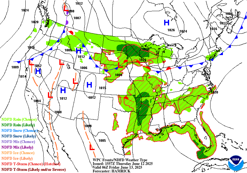
Excessive Rainfall Discussion
NWS Weather Prediction Center College Park MD
415 AM EDT Thu Jun 12 2025
Day 2
Valid 12Z Fri Jun 13 2025 - 12Z Sat Jun 14 2025
...THERE IS A SLIGHT RISK OF EXCESSIVE RAINFALL FOR MUCH OF
ARKANSAS...
The very slow moving upper level trough will continue to drift
across Missouri and Arkansas through the period. Continued
northward advection of deep tropical moisture will run into the
Ozarks as a dryline also gradually pushes east out of the Plains.
The combination of each of these forcings over an area with
topography and likely very wet antecedent soil conditions will all
support continued potential for scattered instances of flash
flooding across much of Arkansas. The heaviest rain will likely
hold off until after midnight Friday night, with the diurnal
strengthening of the low level jet, a faster push of the dryline
and associated sharp gradient in moisture, as well as the peak
divergence as the upper level shortwave trough amplifies a bit.
All of these support the continuation of the Slight Risk over
Arkansas, which was shrunk a bit due to better confidence in the
placement of the heaviest rain, allowing areas further north
towards Paducah to be dropped from the Slight Risk. With the
wettest soils in Arkansas from about Little Rock west, this area
was maintained in a higher-end Slight with this update.
Elsewhere, lingering rain from Minnesota east through the U.P. will
support isolated instances of flash flooding in that region,
largely on Friday morning. A new Marginal Risk was introduced from
southeast Virginia through the Carolinas and into Georgia. While
convection in this area will likely remain disorganized and
dominated by cold pool forcings, the abundance of moisture on the
order of over 2 inches of PWAT will still favor any storms that
form having the capability of multiple inch per hour rainfall
rates. The Marginal from Montana to northeast Colorado was
maintained with minimal changes along the western interface of the
deeper moisture over much of the Plains.
Wegman
Day 2 threat area:
www.wpc.ncep.noaa.gov/qpf/98epoints.txt
Excessive Rainfall Discussion
NWS Weather Prediction Center College Park MD
415 AM EDT Thu Jun 12 2025
Day 3
Valid 12Z Sat Jun 14 2025 - 12Z Sun Jun 15 2025
...THERE IS A SLIGHT RISK OF EXCESSIVE RAINFALL FROM CENTRAL
ARKANSAS THROUGH NORTHERN MISSISSIPPI...
...Arkansas through Alabama...
After multiple days of shower and thunderstorm activity in this
area, there should be some decrease in the organization of the
overall shower and thunderstorm activity expected Saturday from
Arkansas east through Alabama. Despite that decrease, very wet
soils through Mississippi and a lingering frontal boundary
providing some forcing should still lead to enough organization to
support widely scattered instances of flash flooding. For this
region, a Slight Risk area was introduced for Arkansas and
Mississippi with this update. The flash flooding risk has likely
decreased a bit due to a lack of upper level support by Saturday,
so the Slight Risk remains a lower end Slight. Plentiful moisture
over 1.5 inches of PWAT will still support any storms that do form
to be capable of heavy rainfall. Further, a lack of forcing and
organization will increase the time any storms may impact any one
area, to include much of the period, day and night. In other words,
there isn't one specific period of time where the threat for heavy
rain and subsequent flash flooding is significantly higher than any
other point.
...Mid-Atlantic...
A second signal for heavy rain has shown in the guidance across
northern Virginia and into portions of the Tidewater. A slow,
southward moving front over PA will interact with the divergence
ahead of the slow-moving shortwave trough that caused the problems
with flooding further west the past couple days. Since this signal
is relatively new and highly subject to change, a Slight risk
upgrade has not yet been introduced, but is being considered.
Should the heavy rain signal drift north to the DMV area, then a
Slight Risk will likely be needed.
Wegman
Day 3 threat area:
www.wpc.ncep.noaa.gov/qpf/99epoints.txt
Extended Forecast Discussion
NWS Weather Prediction Center College Park MD
149 AM EDT Thu Jun 12 2025
Daily showers and thunderstorms are expected to be widespread from
the Gulf Coast to the Ohio Valley/Mid-Atlantic and into the
Northeast associated with persistent and pesky upper level
impulse/trough energies impacting the broad region. There remains a
lot of uncertainty in the details, but there is some general
agreement that heavier rains may focus along/near a slow moving a
wavy frontal boundary draped across the Mid-Atlantic and westward.
A moist and unstable surrounding environment from the Central to
Eastern U.S. necessity the continuation of a very broad WPC
Marginal Risk area on the day 4 Excessive Rainfall Outlook (ERO)
for at least Sunday. Was able to trim that back to just the Mid-
Atlantic states on Monday, the Day 5 ERO, but showery conditions
will continue farther south and west. Overall signal is for a wet
pattern, and it's likely embedded slight risk areas will be needed
once guidance signals become more defined with time. Farther north,
shortwave energy through the northern tier will support showers
and storms, with marginal risks highlighted on both the Day 4 and 5
EROs for convective complex potential over the northern Plains.
Moderate to heavier rain may try to materialize moreso on
Monday/Day 5 across parts of the north- central U.S. as a stronger
shortwave moves into the Plains, with the Marginal Risk expanded
accordingly.
Temperatures will remain slightly above normal for much of the
Intermountain West into next week under the influence of a mean
upper ridge, with some daily moderation in spots with systems
moving through. Temperatures should be closer to normal along the
coast. To the South, hazardous heat will continue through about
Monday for the Desert Southwest with highs making a run at 110
degrees for the lower elevations of southern Arizona and southeast
California, with Heat Risk likely reaching the major category.
Shortwave energy through the region should moderate temperatures
after Monday. Meanwhile, slightly below average temperatures are
likely from the Upper Midwest to the Great Lakes and northern New
England going into the weekend as this region will be north of the
main frontal boundary.
Santorelli


