Excessive Rainfall Discussion
NWS Weather Prediction Center College Park MD
857 PM EDT Sat Jun 14 2025
Day 1
Valid 01Z Sun Jun 15 2025 - 12Z Sun Jun 15 2025
...THERE IS A SLIGHT RISK OF EXCESSIVE RAINFALL FOR PORTIONS OF
OKLAHOMA AND THE MID ATLANTIC...
...Mid-Atlantic...
Convection moving southeast along a stationary front will result
in isolated to scattered flash flooding this evening across
portions of northern and eastern VA. Given the location of the
front and instability gradient it appears that the heaviest
rainfall rates will remain in VA, and thus we were able to take DC
and MD out of the Slight risk. High PWs and slow cell
motions/mergers near the front will allow for high rainfall rates
and isolated amounts exceeding 3" across portions of northern and
eastern VA.
...Oklahoma...
At least some flash flooding appears likely overnight into early
Sunday across portions of OK. In the mid levels we have a well
defined shortwave across KS, which will slowly drift southward into
OK tonight. To the south of this feature increasing low level
moisture transport/convergence will interact with a highly unstable
airmass. Convection will expand in coverage by later this evening,
and activity should initially be slow moving and exhibit
backbuilding characteristics. This will allow for areas of
excessive rainfall, with recent HRRR and RRFS runs depicting a
swath of 3-5" of rainfall, and both the 18z HREF and REFS showing
over a 40% chance of locally exceeding 5". By later tonight
convection will grow upscale and likely develop a stronger cold
pool resulting in a southward acceleration of convection. High
rainfall rates could still result in a localized flash flood threat
after this faster southward propagation occurs...but the coverage
and magnitude of the threat should be lower by then. Thus the
greater risk is this evening into tonight when convection should
be slower moving and backbuilding...and do consider this a higher
end Slight risk centered over central OK. Scattered flash flooding
is probable, some of which could be locally significant.
...Upper Midwest...
A Marginal risk was maintained across portions of far southeast SD
into IA. Seeing a recent expansion of slow moving convection near
a stationary front which could result in localized flash flooding
through the evening hours.
...Central Montana...
Convection over portions of central and eastern MT will continue
to pose an isolated flash flood risk into the overnight hours.
Recent HRRR runs are likely under doing rainfall amounts over this
area. Recent RRFS runs may be overdone, but likely do have a
better handle on the repeat nature of convection that should
continue into tonight. Impressive CAPE/Shear profiles will
continue to support convective clusters and supercells, and with
PWs over 1", heavy rainfall rates will be likely. Localized
rainfall upwards of 2-3" is possible through the overnight hours.
Chenard
Day 1 threat area:
www.wpc.ncep.noaa.gov/qpf/94epoints.txt
Excessive Rainfall Discussion
NWS Weather Prediction Center College Park MD
309 AM EDT Sun Jun 15 2025
Day 1
Valid 12Z Sun Jun 15 2025 - 12Z Mon Jun 16 2025
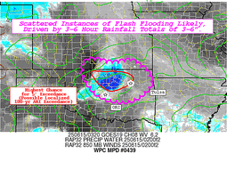
...A MODERATE RISK OF EXCESSIVE RAINFALL EXISTS FOR PORTIONS OF
SOUTHEAST VIRGINIA AND NORTHEAST NORTH CAROLINA...
...Mid-Atlantic and Central Appalachians...
A back door cold front will continue to slow down its forward
progress and idle across the Mid-Atlantic region through Father's
Day. Moist southwesterly flow will intersect this boundary and
result in enhanced moisture convergence and lift. A combination of
ample instability on the order of 1000-2000 J/kg of mixed layer
CAPE, PWs nearing 2 inches, and a strong frontal boundary will set
the stage for additional heavy rain over grounds that are becoming
much more saturated leading up to this. There are two main areas of
increased concern, with the first being over eastern West Virginia
where HREF probabilities of flash flood guidance exceedance are
elevated due to antecedent conditions and the prospects of 1-2
inches of additional rain on Sunday. Although this area still
remains in a Slight Risk, there is the potential that an upgrade to
Moderate Risk may be needed once the event starts to materialize
midday Sunday, so this will continue to be closely monitored.
The other area of concern is across the Tidewater region of
southeast Virginia into adjacent portions of northeast North
Carolina. The 00Z CAM guidance strongly supports swaths of enhanced
QPF from just south of Richmond to the northern Outer Banks, and
rainfall totals on the order of 2-3 inches, and locally higher, are
expected. This would be falling on top of grounds that already had
1-3 inches on Saturday near the U.S. Highway 460 corridor into
Southside Hampton Roads, so that is an aggravating factor. All of
this combined with higher HREF flash flood guidance probs resulted
in areas south of the James River and north of the Albemarle Sound
to now be in a Moderate Risk for this time period.
...Mid-South to the ArkLaTex...
There remains a strong signal for one or more MCSs to develop in
the latest deterministic guidance across Southeast KS and extending
southward through much of Arkansas, owing to MCS propagation into
the area Sunday morning before the official start of the period at
12Z. The remnant MCV will enhance a redevelopment phase of the
regional convective threat over much of Arkansas and into the
ArkLaTex region with some of the CAM guidance showing another 2 to
4 inches for this region, perhaps even higher in some cases where
persistent convective training develops, and thus raise the
potential for flash flood concerns. In this case, there was enough
of a signal to warrant an expansion of the inherited Slight Risk
southward to the ArkLaTex region.
...Upper Midwest...
The expected convective complex over the Dakotas and moving into
Iowa will likely be more on the progressive side compared to the
MCS farther south across Arkansas. However, some of the heavier
rain that is expected will likely happen over more saturated soils
and therefore a higher chance of localized impacts. The 00Z CAM
guidance suite has trended wetter, especially the 3km NAM, and the
global guidance to include the GFS and the CMC also have a more
concentrated QPF signal. Therefore, northwestern Iowa and portions
of adjacent states are now in a Slight Risk area for this time
period.
Hamrick
Day 1 threat area:
www.wpc.ncep.noaa.gov/qpf/94epoints.txt
Excessive Rainfall Discussion
NWS Weather Prediction Center College Park MD
309 AM EDT Sun Jun 15 2025
Day 2
Valid 12Z Mon Jun 16 2025 - 12Z Tue Jun 17 2025
...A MARGINAL RISK OF EXCESSIVE RAINFALL IS VALID FOR PORTIONS OF
THE UPPER MIDWEST, MID-SOUTH, AND THE MID-ATLANTIC...
...Mid-Atlantic region...
Overall, an improvement compared to what is expected over the
weekend, but there should still be enough moisture in the general
vicinity of a stalled stationary boundary over southern Virginia
and North Carolina to produce scattered storms with heavy rainfall.
There is a greater signal in the 00Z guidance for heavier QPF
across central and southern North Carolina, but it does not appear
to overlap much with the Day 1 QPF, so this will tend to mitigate
the flooding potential. Although the magnitude of rainfall
expected on Monday is not impressive, the very saturated ground by
this time across West Virginia and western Virginia will be an
aggravating factor in terms of flooding potential, and therefore a
Marginal Risk area is valid from central West Virginia to the Outer
Banks of North Carolina.
...Mid-South...
The latest model guidance is honing in on a potential MCS that
could develop across portions of eastern Arkansas into western
Tennessee on Monday, and perhaps extending into portions of
southern Missouri and western Kentucky where the potential exists
for 1 to locally 2 inches of rainfall. A Marginal Risk area is
valid here since much of this rain would likely happen over a two
hour time period.
...Dakotas to the western Great Lakes...
Consensus for locally heavy rainfall across portions of the
Northern tier of the CONUS remains favorable across a broad area
extending through the Dakotas, Nebraska, and the Upper Midwest on
Monday. It remains the case that some of the heavier rainfall is
expected over the Sandhills of Nebraska where flash flood guidance
is high, and therefore not rising to the level needed for a Marginal
Risk in that area. Elsewhere, there remains a scattered heavy rain
threat over the northern portions of the Upper Midwest at this
time, and therefore a Marginal Risk remains valid there.
Hamrick
Day 2 threat area:
www.wpc.ncep.noaa.gov/qpf/98epoints.txt
Excessive Rainfall Discussion
NWS Weather Prediction Center College Park MD
309 AM EDT Sun Jun 15 2025
Day 3
Valid 12Z Tue Jun 17 2025 - 12Z Wed Jun 18 2025
...THERE IS A SLIGHT RISK OF EXCESSIVE RAINFALL ACROSS PORTIONS OF
THE MIDWEST STATESâ
...Midwest states...
A well organized mid-upper level shortwave trough will eject
eastward from the Rockies to the central Plains Tuesday afternoon
into the early hours of Wednesday morning, and this will sustain
the development of a surface low that will develop along a frontal
boundary. Upper level dynamics will be favorable as the region will
be place under the right entrance region of the main upper level
jet, and incoming mid-level positive vorticity advection will
further aid ascent. Precipitable water values in the warm sector of
this surface low are expected to rise into the 1.75 to 2 inch
range and an increasing southwesterly low level jet that will
advect copious moisture into the system.
Model guidance has trended a little to the south over the past few
model cycles, with the greatest consensus for the heaviest QPF
across the southern half of Iowa and over the northern third of
Missouri, and extending to northeast Kansas and west- central
Illinois. Most model solutions have a broad corridor of 1-2 inches
with embedded 3-4 inch maxima within this region, with the majority
of this happening within the 18Z Tuesday to 6Z Wednesday time
period. The heavy rain that fell across portions of the Upper
Midwest is generally north of where this expected rainfall will be,
so grounds will not be saturated in most cases leading up to this
event. The inherited Slight Risk from the previous Day 4 outlook
will be maintained with a southward expansion to it, and a broader
Marginal Risk extending across South Dakota and eastward to include
the greater Chicago metro area.
...Appalachians...
The stationary front that will be lingering across the Mid-Atlantic
will start to slowly move back north as a warm front on Tuesday
with anomalous PW values remaining in place. Scattered to numerous
showers and storms, some of which will likely be slow moving, are
forecast to develop during the afternoon and evening hours, mainly
in the 18Z-00Z time period. Parts of the central Appalachians have
been hammered with multiple heavy rainfall events and this has
served to lower flash flood guidance values, and additional heavy
rainfall in the Day 1 and Day 1 periods will only make the ground
more saturated. Therefore, a Marginal Risk is valid from western
North Carolina to western Pennsylvania.
Hamrick
Day 3 threat area:
www.wpc.ncep.noaa.gov/qpf/99epoints.txt
Extended Forecast Discussion
NWS Weather Prediction Center College Park MD
300 PM EDT Sat Jun 14 2025
Overall, it generally still remains the case that highly unsettled
weather will remain in the forecast across much of the
central/eastern U.S. through at least the middle of next week as
numerous embedded impulses in the upper- levels override frontal
boundaries with seasonable moisture in place. Uncertainty remains
with the specific day-to-day details given the short-wave energies,
frontal placement, and likely mesoscale boundaries from prior
days' storms driving new development each day. However, a more
focused corridor is apparent across the central/northern Plains
into the Upper Midwest with daily strong to severe thunderstorm
chances along a couple frontal boundaries. On day 4, Tuesday, QPF
in the guidance shows the potential for locally heavy, multi-inch
rainfall totals with widespread/potentially organized convection,
and a Slight Risk ERO is in place across portions of the Middle
Missouri Valley into the Upper-mid Mississippi Valley. This region
will have also experienced several days of rainfall prior to the
day 4 period, so antecedent conditions should remain wet. Some
additional areal adjustments may be necessary, particularly on the
southern end. Then, on day 5, Wednesday, the focus should shift a
bit eastward from the Upper Mississippi Valley into the Great Lakes
region and a Marginal Risk ERO remains. QPF in the model guidance
and a continued favorable pattern for organized convective
development suggest that a localized higher threat is possible, but
greater uncertainty in the location/areal coverage of this threat
as well as less sensitive antecedent conditions compared to the
prior day preclude higher probabilities at this time. In addition
to heavy rainfall/flash flooding, the Storm Prediction Center has
also highlighted portions of the Central Plains on Tuesday and the
Upper Mississippi Valley Wednesday for a severe weather risk as
seasonably strong instability and sufficient shear will bring the
threat for large hail and damaging winds, particularly with any
organized convective systems. Expect the focus for storms to shift
south and eastward Thursday- Saturday with eastward movement of
upper- troughing/associated surface frontal boundaries and upper-
level ridging beginning to build in over the central U.S, though
some additional shortwave energy could bring renewed precipitation
chances to the Midwest. A signal also remains for an enhanced
tropical moisture feed from the Gulf to northeast Mexico and South
Texas/West Gulf Coast next weekend to monitor for signs of system
development out from the Bay of Campeche/vicinity with the
potential for heavy rainfall. The approach of an upper-low/Pacific
system looks to bring some increasing precipitation chances to the
Pacific Northwest and over the West late next week/weekend.
Expect above average temperatures across the Intermountain West
and adjacent portions of the Plains and Southwest to generally
persist through next week as an amplifying pattern will support
broadening upper-ridging following the passage of an upper-wave
earlier in the week. Some more locally intense heat will continue
across portions of the Southwest into the southern High Plains/west
Texas through at least Tuesday as highs rise into the low to
mid-100s. Summer- like temperatures/muggy conditions will expand
from the Plains east through the Mississippi/Ohio Valleys and into
the Southeast/Mid- Atlantic ahead of an upper-wave/cold front. The
most intense heat will likely focus along the Gulf Coast, the Lower
Mississippi Valley, and along the Eastern Seaboard north through
the Carolinas and into the southern Mid- Atlantic, with heat
indices greater than 105 expected. The cold front passage may bring
some relatively more comfortable conditions from the Ohio Valley
east into Carolinas/Mid-Atlantic late next week/weekend. Highs will
begin to trend relatively cooler and below average across portions
of the Northwest and possibly further south along the West Coast
by late next week/weekend as an upper-low from the northeast
Pacific begins to overspread the region.
Putnam


