Excessive Rainfall Discussion
NWS Weather Prediction Center College Park MD
342 PM EDT Wed Jun 11 2025
Day 1
Valid 16Z Wed Jun 11 2025 - 12Z Thu Jun 12 2025
...THERE IS A MODERATE RISK OF EXCESSIVE RAINFALL FOR PORTIONS OF
CENTRAL TEXAS...
...Texas...
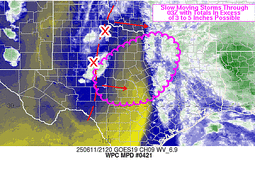
16Z Update: The forecast premise remains the same with 12z CAMs
finally all catching on to a better degree of what has occurred,
what is occurring, and general expectations going forward. Expected
to see a redevelopment of convection across East-Central TX this
afternoon within a pocket of higher theta_E remaining over the I-45
corridor between DFW/HOU, aligned well within the higher CAPE,
lower CIN depiction on the recent RAP Mesoanalysis. This will
congeal and move northeast allowing for some of the areas hit hard
this morning to get hit again in wake of the departing complex
moving through the ArkLaTex. Multiple FFW's have occurred to the
southeast of the DFW metro, an area where local FFG's have taken a
hit over the past 24-36 hrs. This setup will allow for a continued
impact in those zones, so the MDT was expanded a bit further to the
northeast to account for the trends in the latest CAMs and
impacted areas.
ULL progression over West TX will maintain a posture of relatively
modest buoyancy returning over the Concho Valley down through the
eastern Edwards Plateau and adjacent Hill Country by late-afternoon
and evening. Stronger mid-level perturbations pivoting around the
ULL center will eventually rotate back around and provide a
significant increase in regional ascent within the above zone
leading to cell initiation back over areas hit pretty hard the past
24 hrs. Incredibly low FFG's (<1" over 1/3/6 hr intervals) are
centered over Hill Country with much of the CAMs depicting some
action moving back over the area creating an environment capable of
inducing flash flood prospects over the region as CAMs print out
1-2"/hr rates in some of the stronger convection in the area. By
the evening, the increasing large scale forcing will navigate into
Central TX with the I-35 corridor between DFW to San Antonio and 50
miles either side becoming the primary target for heavy rainfall.
Return flow within the 850-700mb level is expected to allow for
greater low-level convergence across the area with convection
orienting more southwest to northeast with some training prospects
along the tight theta_E gradient anticipated between eastern Hill
Country and the I-45 corridor. HREF blended mean QPF is very high
(3-5") within the I-35 corridor between Austin to Waco leading to
40-60% neighborhood probs for >5" over the area. Will need to
monitor for areas south of Austin as a secondary maxima down
towards New Braunfels and San Antonio has been showing up on
guidance with some of the higher probs for >5" also expanding into
that zone. With those locations inheriting higher FFG's, prospects
for flash flooding a bit less than those to the north, but a
higher-end SLGT is now forecast for that area with some potential
of an expansion of the MDT if trends continue.
The SLGT was removed over CRP and parts of Deep South TX in
conjunction with radar trends. The southern tip of TX, including
the Brownsville/McAllen area was removed from any ERO as the area
will maintain a relative min in QPF for the period.
Kleebauer
..Previous Discussion..
In coordination with FWD/Dallas, TX and HGX/Houston, TX forecast
offices, a Moderate Risk upgrade was introduced with this update
for portions of central Texas. As is typical with summertime
convection, the signal is a mess. The current MCS in central Texas
is largely agreed upon in the CAMs guidance to persist well into
the afternoon and advance across the rest of east Texas and into
Louisiana, as a broken but slow moving line of storms. Most of the
guidance suggests new convection will form in the afternoon with
peak heating and instability across the Texas Moderate and Slight
Risk areas. Those storms will generally track north and east,
which will follow behind the first round of storms into east
Texas. Most importantly, yet another round forms during the
overnight, likely in the Moderate Risk area. This too will
organize into an MCS, but the southern end of those storms may hang
back and backbuild, resulting in prolonged heavy rain in a narrow
swath somewhere in central Texas.
While this is the broad scenario expected, the details of each
round of storms will play a large role as to the coverage and
severity of flash flooding today and tonight. The majority of the
guidance suggests this will be most prevalent in the Moderate Risk
area of central Texas, but this is far from unanimous, with a
second grouping of guidance suggesting these storms form further
south towards Houston. Thus, this is an unusually low confidence
Moderate Risk for the Day 1 period. Compounding concerns is that
much of northern and central Texas has seen multiple rounds of
heavy rain in recent days, including at present, which has
sufficiently saturated soils across the area. Thus, multiple inches
of rain associated with these storms which will be drawing on air
with PWATs to 2 inches, will quickly overwhelm streams and creeks,
especially in urban areas, resulting in flash flooding. These very
favorable antecedent conditions have also contributed to confidence
increasing for a Moderate Risk upgrade.
HREF guidance should neighborhood probabilities for at least 3
inches of rain today and tonight in the Moderate Risk area of over
70%, and a 20-50% chance of over 5 inches of rain. Given the
abundance of moisture available, both slow moving storms, multiple
rounds of heavy rain in some areas, and the potential for training
and back building will all work to increase the flash flooding
potential across much of eastern Texas, also supporting the
Moderate Risk upgrade.
As the convective evolution becomes more clear through the day and
into tonight, it's likely there may need to be adjustments to the
Moderate Risk area, which as mentioned above, appears most likely
to extend south to the Houston Metro. However, given the multiple
rounds of rain that have impacted the DFW Metroplex in recent days,
and the heavy rain that has hit San Antonio over the past few
hours, any storms favoring any of those metros could require the
Moderate Risk to expand to those areas of the Texas Triangle.
Wegman
...Gulf Coast through the Carolinas...
16Z Update: Minor expansion north of the MRGL across parts of the
Lower Mississippi Valley as 12z CAMs came in a bit north with the
heavier precip today. Still looking at locally robust rates of
2-3"/hr in the heaviest convection, but very much more pulse
variety as you align between Central LA across the South and up
into the VA Tidewater. Modest neighborhood probabilities for >3"
(35-50%) exist over parts of the Central Gulf Coast and Coastal NC,
so the threat for at least low-end MRGL persists. No changes we
made in those regions.
Kleebauer
..Previous Discussion..
A stalled front along the Gulf Coast will act as a focus for
afternoon and evening convection due to an abundance of Gulf
moisture available for the storms to draw from. The broad Marginal
Risk remains in place for all of the rest of the Gulf Coast and
through the Carolinas. The signal has expanded a bit north so the
Marginal was expanded north as well to the Hampton Roads area.
Wegman
...Upper Midwest...
16Z Update: The MRGL was expanded a bit eastward to include
western Milwaukee metro, but otherwise the threat remains on the
low-end of MRGL. A relatively high probability on the EAS of at
least 1" across parts of Northern IA and Southwest WI exist
(60-80%), but a significant drop off in the probs (<15%) for at
least 2" means the threat is capped between 1-3" for the general
max. With antecedent moisture pretty low over the area, this is a
setup coincident with a MRGL.
Kleebauer
..Previous Discussion..
The Marginal Risk in the area around the MN/IA border has been left
largely unchanged, with most of the concerning convection likely
occurring late tonight at the nose of the LLJ.
Wegman
...Idaho/Montana...
16Z Update: PWATs running between 1.5-2.5 deviations above normal
across the Northern Rockies and interior PAC NW will lead to
locally heavy rainfall potential over Eastern OR through much of
ID/MT/WY this afternoon and early-evening before dissipating with
loss of diurnal heating. CAMs indicate the risk of 1-2" of rainfall
in heavier cores which would certainly cause problems in any urban
zones and remnant burn scares. The MRGL was expanded through WY and
adjusted a touch south. The threat remains sufficient for a broad
risk area given the environment in place.
Kleebauer
..Previous Discussion..
The Marginal Risk was left largely unchanged here as well with
periods of rain occurring over mostly hydrophobic soils resulting
in localized flash flooding, particularly around any burn scars.
Wegman
Day 1 threat area:
www.wpc.ncep.noaa.gov/qpf/94epoints.txt
Excessive Rainfall Discussion
NWS Weather Prediction Center College Park MD
342 PM EDT Wed Jun 11 2025
Day 2
Valid 12Z Thu Jun 12 2025 - 12Z Fri Jun 13 2025
...THERE IS A SLIGHT RISK OF EXCESSIVE RAINFALL FOR THE ARKLATEX
REGION AND MUCH OF EASTERN TEXAS AS WELL AS FOR SOUTHERN MINNESOTA
INTO WESTERN WISCONSIN...
...Arklatex Region & East Texas...
20Z Update: Modest expansion of the SLGT risk was necessary given
the forecast QPF footprint of the heavier returns as far south as
San Antonio and as far east as the middle TX coast. High-end SLGT
is forecast for much of East TX through the ArkLaTex where
antecedent soil moisture will be elevated after today's activity
with a large 2-4+" rainfall likely dropping area FFG's
significantly by this evening. 12z HREF neighborhood probabilities
are relatively high (20-40%) for >5" across the area between
CRP/EWX/HOU with a secondary probability maxima located over the
ArkLaTex (15-30%). Guidance is coming into alignment on the
heaviest precip being located in these two zones with scattered
high amounts in the middle of the two regions, mainly within the
I-45 corridor. A MDT risk was debated, but with the convective
scheme initially still under some uncertainty, did not want to
initiate an upgrade if trends in overnight QPF shift in positioning
or magnitude. HREF EAS signals are high for >1" but drop off
significantly when assessing >2", so there's still some discrepancy
on specifics. Like for the D1, if models trend more favorably for
any one area, there is a chance for a targeted upgrade over either
of the two regions. For now, a broad SLGT risk remains with
expansion through the Ozarks given the recent convective QPF trends
over the more sensitive area for flash flood prospects.
Kleebauer
..Previous Discussion..
Strong southerly flow of deep Gulf moisture will continue across
east Texas and the Arklatex region on Thursday. There will very
likely be an ongoing MCS across eastern Texas at the start of the
period Thursday, which will progress eastward into Arkansas and
Louisiana through the day. There may be a lull in most of the
shower and thunderstorm activity for the afternoon hours in many
areas, but renewed activity will develop through the evening as the
LLJ restrengthens, and a slow moving upper level shortwave helps
drive a dryline east over Oklahoma and Texas, which will cause
numerous storms to form and organize into an MCS near the Arklatex
region through the overnight, as PWATs remain up near 2 inches,
promoting very heavy rainfall with the strongest storms. Once
again, this region has been hard hit with heavy rain in recent
days, and therefore this latest round of heavy rain will not take
much to result in flash flooding. Depending on how much rain falls
in this region on Day 1/Wednesday, it is possible a Moderate Risk
upgrade may be needed for this region as well as confidence
increases and the CAMs include the Thursday night period. There is
enough uncertainty as to how far west the storms are (which will be
highly dependent on the placement of the dryline), and therefore,
the Metroplex, Houston, and Austin remain included in a higher end
Slight Risk, which extends into the southeast corner of Oklahoma
and adjacent western Arkansas counties.
Wegman
...Southern Minnesota into Western Wisconsin...
20Z Update: The SLGT risk expansion to the north was initiated for
the afternoon update, once again with the general QPF maxima
bisecting the I-94 area and points west. A strong signal for >2" of
rainfall is now present within the latest HREF EAS prob fields
(40-60%), a testament to the consistency in CAMs with the placement
of the heaviest QPF maximum that's forecast. Areal average totals
of 2-3" are becoming more likely with the setup with local maxima
between 4-6" plausible as neighborhood probs for >5" run between
40-60%, as well across west-central MN. Training threat is the
reasoning for this potential with hourly rates likely between
1-2"/hr in the heaviest convective cores. Area FFG's are modest
within each 1/3/6 hr interval, but could still take some rainfall
initially prior to problems ensuing. Considering all of the above,
the SLGT risk was generally maintained, but did adjust the overall
risk area further west to account for the latest QPF shift in the
hi-res and bias corrected ensemble.
Kleebauer
..Previous Discussion..
At the nose of the upper level jet, a mesolow is likely to form
over the central Plains Thursday afternoon, which will then drift
northeast into Iowa on Thursday night. Abundant Gulf moisture will
ride northward ahead of the low, running into a strong stationary
front which will likely be set up over central Minnesota. This
front will provide the lift for training and backbuilding
thunderstorms across much of southern Minnesota Thursday afternoon
and evening. The storms appear likely to impact all of the Twin
Cities and surrounding suburbs, which when added to the wetter
soils from any rainfall from Day 1/Wednesday, may result in widely
scattered instances of flash flooding. The Slight Risk area was
nudged northward with this update, following the latest changes in
the ensemble guidance, but rainfall amounts are largely unchanged.
Wegman
...Carolina Piedmont through East Georgia...
A combination of elevated moisture across the Southeast and strong
differential heating away from the coastal plain will lead to a
corridor of enhanced SBCAPE on the order of 2500-3500 J/kg across
East GA up through the western half of the SC Piedmont. Scattered
to numerous thunderstorms with relatively slow storm motions will
enhance locally heavy rainfall capabilties with rates between
2-3"/hr plausible in a few of the stronger cores. Urbanized zones
within the region referenced above will be the most susceptible for
flash flooding prospects with some of the latest CAMs going as high
as 4-6" in some of the greater outputs anticipated. A MRGL risk was
added to convey the threat and correlates well with the latest UFVS
First Guess Fields.
Kleebauer
Day 2 threat area:
www.wpc.ncep.noaa.gov/qpf/98epoints.txt
Excessive Rainfall Discussion
NWS Weather Prediction Center College Park MD
342 PM EDT Wed Jun 11 2025
Day 3
Valid 12Z Fri Jun 13 2025 - 12Z Sat Jun 14 2025
...THERE IS A SLIGHT RISK OF EXCESSIVE RAINFALL FOR THE ARKLATEX
REGION INTO PORTIONS OF THE MID-MISSISSIPPI VALLEY...
20Z Update: Main change in the period was a split of the MRGL risk
across the Great Lakes/Ohio Valley area with now two separate risk
areas with a large nil between the areas of interest. The SLGT risk
threat with higher end potential still exists over the ArkLaTex
into the Arkansas Ozarks with a chance at a targeted upgrade given
the overlap signature of heavy rainfall (ArkLaTex) for 3
consecutive periods. Ensemble bias corrected QPF trended a bit
north with the heavier precip footprint, but this might be
attributed more to the bias of a few models likely too far north
with the expected maxima. Didn't deviate too far away from what was
inherited across the Lower Mississippi Valley.
The MRGL risks in place are on the lower end of the threshold with
more isolated flash flood risks comparitively in either region.
Best risk will likely be over Northern WI up towards Duluth for the
Midwest MRGL and across MT for the western MRGL risk where ascent
pattern is most favorable.
Kleebauer
..Previous Discussion..
A slow-moving upper level trough will drift east across Oklahoma
and Arkansas through the period. It will draw on abundant Gulf
moisture with PWATs at or above 2 inches to force numerous slow
moving thunderstorms to develop from northeast Texas northeast to
the Mississippi-Ohio River confluence. The southerly flow will also
upslope into the Ozarks of central Arkansas, likely resulting in
localized increases in rainfall rates across much of Arkansas on
Friday and especially into Friday night. Given the expanded
eastward movement of the storms, the inherited Slight Risk was
expanded significantly north and east into the mid-Mississippi
Valley with this update. A higher-end Slight is in effect for the
Arklatex region through much of central Arkansas, where the
heaviest rainfall is expected. Periods of heavy rain across the
Arklatex and western Arkansas are expected from the Day 2/Thursday
period, which will greatly moisten the antecedent soil conditions
in advance of the heavy rainfall expected on Friday and Friday
night. Here too, a Moderate Risk upgrade may be needed with future
updates should the preponderance of guidance remain consistent at
targeting the Arklatex and central Arkansas with the heaviest
rainfall.
New Marginal Risk areas were added across much of the Great Lakes,
where training storms may cause isolated flash flooding, the
northeast corner of Colorado due to some upslope with the flow
turning southeasterly into an expected stationary front over that
area, and the third consecutive day of moderate rainfall across
much of central Montana, aided by increasing divergence ahead of a
potent shortwave moving across the Pacific Northwest by Friday
night. In each of these areas, only isolated flash flooding is
expected as the signal for heavy rain in these areas remains
diffuse.
Isolated to scattered disorganized convection is likely to impact
much of the eastern seaboard Friday afternoon with peak heating.
Given the increasing moisture moving up the coast, any storms that
remain in a given area for too long or backbuild along their cold
pools could cause isolated instances of flash flooding. Given a
lack of discernible forcing, for now have left the area out of a
Marginal citing a less than 5% chance of flash flooding, but the
threat is non-zero. The Marginal may need to be expanded eastward
across much of the eastern seaboard in the coming days should
current trends continue.
Wegman
Day 3 threat area:
www.wpc.ncep.noaa.gov/qpf/99epoints.txt
Extended Forecast Discussion
NWS Weather Prediction Center College Park MD
259 PM EDT Wed Jun 11 2025
Daily showers and thunderstorms are expected to be widespread from
the Southern Plains and Gulf Coast to the Ohio Valley/Mid-Atlantic
and into the Northeast associated with persistent and pesky upper
level impulse/trough energies impacting the broad region. There
remains a lot of unertainty in the details, but there is some
general agreement that heavier rains may focus along/near slow
moving and wavy draping frontal boundaries and with local
boundaries with a moist and unstable surrounding environment from
the central to eastern U.S.. Opted to maintain very broad WPC
Marginal Risk areas on both the days 4 and 5 Excessive Rainfall
Outlooks (EROs) for this weekend stretched from the Southern
Plains and Gulf Coast northeastward through the Tennessee/Ohio
Valleys to the Mid-Atlantic. These areas continue to become
slightly more defined as we lead into the event. This is a wet
pattern. It is highly likely embedded Slight Risks areas will be
needed once guidance signals become more defined closer to
occurance. Farther north, shortwave energy through the northern
tier will support showers and storms, with a marginal risk
highlighted on the Day 5/Sunday ERO for convective complex
potential over the northern Plains. Moderate to heavier rain may
try to materialize across parts of the north- central U.S. to
monnitor next week as a stronger shortwave moves into the Plains.
Temperatures should remain slightly above normal for much of the
Intermountain West this weekend under the influence of an upper
ridge. Temperatures should be closer to normal along the coast.
Shortwave energy moving into the region next week should help
moderate temperatures across the Interior West somewhat. To the
South, heat will build across the Desert Southwest with highs
making a run at 110 degrees for the lower elevations of southern
Arizona and southeast California, with Heat Risk likely reaching
the major category by Sunday and Monday, with additional threat
extending well into next week. Meanwhile, slightly below average
temperatures are likely from the Upper Midwest to the Great Lakes
and northern New England going into the weekend as this region will
be north of the main frontal boundary.
Schichtel/Santorelli


