Excessive Rainfall Discussion
NWS Weather Prediction Center College Park MD
342 PM EDT Tue Jun 10 2025
Day 1
Valid 16Z Tue Jun 10 2025 - 12Z Wed Jun 11 2025
...THERE IS A SLIGHT RISK OF EXCESSIVE RAINFALL FOR PORTIONS OF
TEXAS...
...Texas...
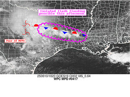
Another round of showers and thunderstorms will impact portions of
southern and western Texas this afternoon into tonight. Ongoing
convection over northeastern Texas is slowly weakening though new
activity is developing downstream over LA along an elevated
boundary.
New storms should develop this afternoon across the Trans-Pecos
and Edwards Plateau regions of west Texas. Deep Gulf moisture (PW
values > 1.5" or +2 sigma) combined with maximum solar heating will
allow instability to become extreme in some areas, likely
exceeding 4,000 J/kg. Thus, in addition to any severe threat, the
storms will be more than capable of producing very heavy rain, with
rates of 3+ inches per hour with the strongest storms. The storms
will likely congeal in the Edwards Plateau region late in the
afternoon, generally following the Rio Grande south and east. With
atmospheric moisture only increasing as the storms move towards the
Gulf, they will remain prolific rainmakers well into the overnight
hours. 12Z HREF probs still show 3"/hr probs >30% in some areas.
Soils across the Edwards Plateau and south-central Texas are very
dry, with most of the recent heavy rainfall occurring well north of
this area. While this will work to inhibit riverine flooding, the
soils should initially be quite hydrophobic because they've been so
dry, increasing the flash flooding threat. Thus, a higher end
Slight is in effect for the area from San Antonio west to the Rio
Grande.
...Southeast and Northeast...
Elsewhere, a stalled out front just inland from the Gulf Coast in
the Southeast may act as a catalyst for additional convection from
eastern Texas eastward to the Carolinas. Despite the presence of
the front and plenty of tropical moisture, there will be little to
organize the storms. The Marginal Risk was maintained with an
expectation of only isolated heavier rainfall. Farther north,
rainfall ahead of an advancing cold front into the Northeast may
add to soggier soils from this morning's rainfall, so the Marginal
Risk outline was maintained here as well for this afternoon.
Wegman/Fracasso
Day 1 threat area:
www.wpc.ncep.noaa.gov/qpf/94epoints.txt
Excessive Rainfall Discussion
NWS Weather Prediction Center College Park MD
342 PM EDT Tue Jun 10 2025
Day 2
Valid 12Z Wed Jun 11 2025 - 12Z Thu Jun 12 2025
...THERE IS A SLIGHT RISK OF EXCESSIVE RAINFALL FOR PORTIONS OF
TEXAS AND SOUTHERN OKLAHOMA...
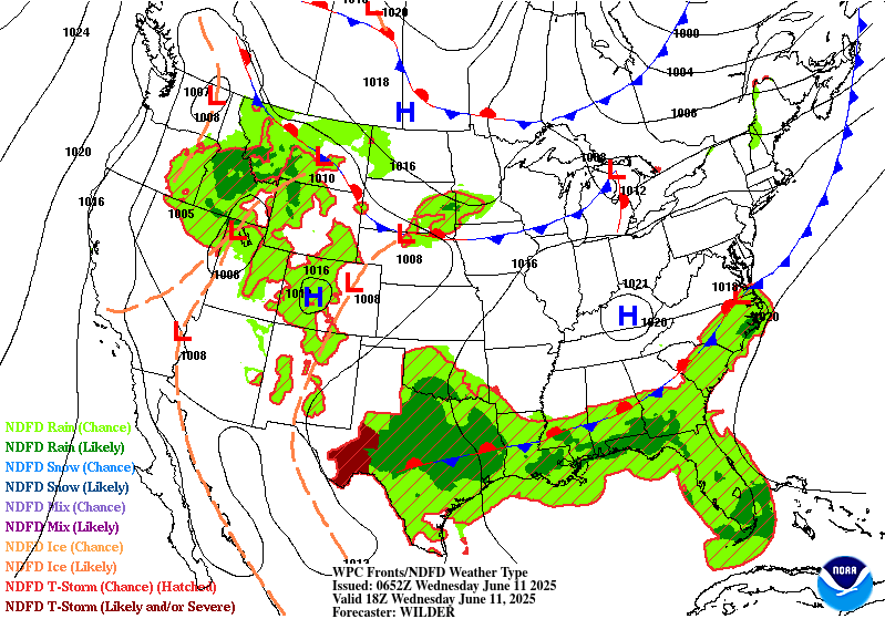
...Texas into the Southeast...
A strong low-level jet will continue to advect abundant Gulf
moisture northward across the southern Plains on Wednesday. This
moisture will run into the dryline across west Texas, which in turn
will result in renewed rounds of convection forming along the
dryline, or remnant cold pool boundaries from prior convection. The
new storms will drop their own cold pools, likely causing
additional convection. Since moisture replenishment will be
constant, the storms should have no trouble maintaining themselves
as they move across Texas. Expect at least some morning convection
to be ongoing at the start of the period from the overnight storms
in Day 1 which have acted to increase soil moisture (and lower FFG
values). However, as on previous days, the lion's share of the
heavy rainfall across Texas will result from afternoon convection
congealing into one or more MCSs during the overnight period when
the LLJ ramps up.
The primary source of uncertainty, as is very common with
convection, is where the convection forms. Depending on the
guidance, that could be anywhere across the eastern half of Texas.
While the consensus is along the I-35 corridor from south of San
Antonio to the Oklahoma state line, the variance longitudinally is
from the Permian Basin to the Louisiana state line and has not yet
converged even with another cycle of guidance. This uncertainty
with both where the convection will form and how organized it will
be largely precluded any potential Moderate Risk upgrades, although
several urban areas including the Metroplex, Waco, Austin, and San
Antonio may all have a higher flash flooding threat. Further, their
remains a separation (north-south) between the HREF guidance and
RRFS ensemble guidance, which also reduced any confidence in any
upgrades at this time. However, the rather high 10th percentile
amounts nearing 0.75-1.00" around and just south of the Metroplex
does decrease the potential for just Marginal impacts. 90th
percentile QPF was well above 4-6" with some more aggressive CAMs
showing closer to 10" over the 24-hr period. Both the GEFS
M-Climate QPF (near max values) and ECMWF EFI/SoT (0.7-0.8/near 1)
suggest that potential is real.
Elsewhere across the Southeast, the abundance of atmospheric
moisture all along the Gulf Coast should support almost any
convection having at least some potential to cause isolated flash
flooding. Tidal flooding with the full Strawberry Moon may
compound any flooding from rainfall at the shore. Maintained the
expansive Marginal Risk that also includes Florida where a modest
surge in moisture may support heavier rain totals over
southern/southwest portions of the state.
...Western High Plains and the Corn Belt...
The Marginal Risks in the upper Midwest and across much of Montana
were largely unchanged with this update. The LLJ, or an extension
thereof, will provide moisture for storms to draw from in both
these areas, as upper level shortwave disturbances provide the
forcing for those storms to form and loosely organize. Drier soils
in these areas should preclude all but an isolated flash flooding
threat. However, more sensitive areas along the Divide/Northern
Rockies would also be at risk from comparatively less QPF than
farther east.
Wegman/Fracasso
Day 2 threat area:
www.wpc.ncep.noaa.gov/qpf/98epoints.txt
Excessive Rainfall Discussion
NWS Weather Prediction Center College Park MD
342 PM EDT Tue Jun 10 2025
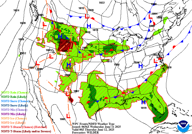
Day 3
Valid 12Z Thu Jun 12 2025 - 12Z Fri Jun 13 2025
...THERE IS A SLIGHT RISK OF EXCESSIVE RAINFALL FOR PORTIONS OF THE
SOUTHERN PLAINS AS WELL AS FOR SOUTHERN MINNESOTA...
...Southern Plains...
Mid-level shortwave will slowly move through the area Thursday but
will favor a similar area in eastern Texas as day 2. Plentiful
Gulf moisture from an increasingly strong LLJ continues to advect
northward across the southern Plains. It appears that the storms
will shift slightly further east as compared to Wednesday, but the
I-35 corridor from San Antonio through the Metroplex to Oklahoma
City appears to still be in the bullseye for the most rainfall,
especially in Texas. While a higher-end Slight was maintained across
this area, a Moderate Risk areas may be needed depending on how the
rainfall footprint evolves over the next two days. The guidance is
all over the place, which is fairly normal for a Day 3 forecast
for convection in the summer, with hints of a north-south
bifurcation in the QPF (e.g., GFS, RRFS, and ECMWF-AIFS QPF).
...Southern Minnesota...
Northern extent of the plume of Gulf moisture will surge northward
and intersect a mid-level shortwave and surface boundary from
southern SD eastward into southern MN. This setup will support
training and backbuilding thunderstorms across southern Minnesota,
including the Twin Cities, on Thursday. With some potential for
overlap on the southern side of the storms with rainfall from the
Day 2/Wednesday period, the Slight Risk was maintained from
overnight. Model QPF was quite displaced north-south across MN
(e.g., NAM, GFS, and RRFS farther north) but will hedge on the
southern side of the QPF spread closer to the better instability
(and playing into the typical bias). Storms are likely to develop
further west back across the Dakotas and eastern Montana, but the
greatest forcing and thus, highest risk of flash flooding will be
into Minnesota.
Wegman/Fracasso
Day 3 threat area:
www.wpc.ncep.noaa.gov/qpf/99epoints.txt
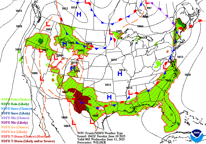
Extended Forecast Discussion
NWS Weather Prediction Center College Park MD
259 PM EDT Tue Jun 10 2025
An unsettled weather pattern is expected to be in place across a
large portion of the Central U.S. to close out the work week.
Additional heavy rainfall is likely across the Arklatex region
going into the new Day 4 period Friday with a southern stream
shortwave positioned over Texas. Maintained the inherited Slight
Risk area for Friday, where the potential exists for a fast
multiple
inches of rainfall from thunderstorm and potential MCS activity,
and this would be falling atop soils that will probably be
saturated owing to rainfall in the days leading up to this. There
should also be at least scattered showers and storms from the
western Gulf Coast and extending northward across the Mid-South,
but ensemble signal is not very strong for any particular place in
the broad area, so shrank the Marginal Risk area accordingly.
Farther to the north across the Upper Midwest and Great Lakes, a
wave of low pressure along a quasi-stationary boundary may fuel the
development of scattered to numerous showers and thunderstorms
from Wisconsin to Lower Michigan where a Day 4/Friday Marginal Risk
area remains in place. Going into Day 5/Saturday, a broad Marginal
Risk area is planned from the west-central Gulf Coast to the
Catskills of New York to include some of the lower FFG values and
favored terrain. The current guidance signal remais mixed in
guidance for firm locations that limits issuance of any Slight Risk
areas that will need to be monitorred closer to occurance.
Temperatures will continue to be quite warm across much of the
Intermountain West for the entire forecast period as this region
will be under the influence of an upper ridge, although a slow
moving cold front from the Pacific will keep readings closer to
climatology from the Pacific Northwest to western Nevada/northern
California. Heat will also be building across the Desert Southwest
with highs making a run at 110 degrees for the lower elevations of
southern Arizona and southeast California, with Heat Risk likely
reaching the major category by Sunday into Monday, with additional
threat extending well into next week. Meanwhile, slightly below
average temperatures are likely from the Upper Midwest to the Great
Lakes and northern New England going into the weekend as this
region will be north of the main frontal boundary.
Schichtel/Hamrick


