


Valid Sat Jun 14, 2025
Valid Sun Jun 15, 2025
Valid Mon Jun 16, 2025


+ Additional Links
- » Description of the National Forecast Chart
- » Product Archives
- » Download hazards in KML or shapefile format or GeoJSON format


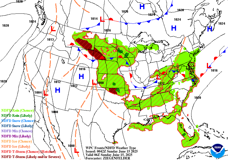


NWS Weather Prediction Center College Park MD
403 PM EDT Sat Jun 14 2025
Valid 00Z Sun Jun 15 2025 - 00Z Tue Jun 17 2025
...There is a Slight Risk of excessive rainfall over parts of the
Mid-Atlantic and Central/Southern Plains on Saturday and Sunday...
...There is a Slight Risk of severe thunderstorms over parts of the
Northern/Central High Plains and Southern Plains on Saturday and the
Northern/Central Plains on Sunday/Monday...
A quasi-stationary front extending from the Mid-Atlantic to the Central
High Plains will remain through Tuesday. South of and along the boundary,
upper-level energy and abundant moisture will produce showers and
thunderstorms from south of the Great Lakes/New England to the Gulf Coast
and from Northern Plains/Upper Mississippi Valley to the Gulf Coast for
the rest of Saturday. Two regions of heavy rain will be embedded in the
larger mass of showers and thunderstorms. The first area will be over the
Mid-Atlantic. Therefore, the WPC has issued a Slight Risk (level 2/4) of
excessive rainfall over parts of the Mid-Atlantic through Sunday morning.
The associated heavy rain will create mainly localized areas of flash
flooding, with urban areas, roads, small streams, and low-lying areas the
most vulnerable.
The second area will cover parts of the Central/Southern Plains and the
Middle/Lower Mississippi Valley. Therefore, the WPC has issued a Slight
Risk (level 2/4) of excessive rainfall over parts of the Central/Southern
Plains and the Middle/Lower Mississippi Valley through Sunday morning.
The associated heavy rain will create mainly localized areas of flash
flooding, with urban areas, roads, small streams, and low-lying areas the
most vulnerable.
In addition, the upper-level energy and moisture will create showers and
severe thunderstorms over parts of the Northern/Central High Plains.
Therefore, the SPC has issued a Slight Risk (level 2/5) of severe
thunderstorms over parts of the Northern/Central High Plains through
Sunday morning. The hazards associated with these thunderstorms are
frequent lightning, severe thunderstorm wind gusts, hail, and a few
tornadoes. However, there is an increased risk of hail, two inches or
greater, over the Northern High Plains.
Likewise, another area of upper-level energy and moisture will create
showers and severe thunderstorms over parts of the Central/Southern
Plains. Therefore, the SPC has issued a Slight Risk (level 2/5) of severe
thunderstorms over parts of the Central/Southern Plains through Sunday
morning. The hazards associated with these thunderstorms are frequent
lightning, severe thunderstorm wind gusts, hail, and a few tornadoes.
On Sunday, another area of upper-level energy and abundant moisture will
produce showers and thunderstorms from south of the Great Lakes/New
England to the Gulf Coast and from the Northern Tier States, west of the
Great Lakes to the Gulf Coast. Similarly, there will be two regions of
heavy rain embedded in the larger mass of showers and thunderstorms. The
first area will be over the Mid-Atlantic/Central Appalachians. Therefore,
the WPC has issued a Slight Risk (level 2/4) of excessive rainfall over
parts of the Mid-Atlantic/Central Appalachians from Sunday through Monday
morning. The associated heavy rain will create mainly localized areas of
flash flooding, with urban areas, roads, small streams, and low-lying
areas the most vulnerable.
The second area will be over parts of the Central/Southern Plains and a
larger area of the Middle/Lower Mississippi Valley. Therefore, the WPC has
issued a Slight Risk (level 2/4) of excessive rainfall over parts of the
Central/Southern Plains and the Middle/Lower Mississippi Valley from
Sunday through Monday morning. The associated heavy rain will create
mainly localized areas of flash flooding, with urban areas, roads, small
streams, and low-lying areas the most vulnerable.
However, there will be a larger area of severe thunderstorms over parts of
the Northern/Central Plains. Therefore, the SPC has issued a Slight Risk
(level 2/5) of severe thunderstorms over parts of the Northern/Central
Plains from Sunday through Monday morning. The hazards associated with
these thunderstorms are frequent lightning, severe thunderstorm wind
gusts, hail, and a few tornadoes. However, there is an increased risk of
hail, two inches or greater, and severe thunderstorm wind gusts 65 knots
or greater over the Northern High Plains.
By Monday, the threat of excessive rainfall tapers off to a few marginal
risk areas over the Mid-Atlantic, Northern Plains/Upper Mississippi
Valley, and Middle/Lower Mississippi Valley/Tennessee Valley.
Moreover, the moisture and upper-level energy will trigger severe
thunderstorms over parts of the Northern/Central Plains and Upper/Middle
Mississippi Valley on Monday. Therefore, the SPC has issued a Slight Risk
(level 2/5) of severe thunderstorms over parts of the Northern/Central
Plains and Upper/Middle Mississippi Valley on Monday. The hazards
associated with these thunderstorms are frequent lightning, severe
thunderstorm wind gusts, hail, and a few tornadoes.
Ziegenfelder
Graphics available at
https://www.wpc.ncep.noaa.gov/basicwx/basicwx_ndfd.php
NWS Weather Prediction Center College Park MD
300 PM EDT Sat Jun 14 2025
Valid 12Z Tue Jun 17 2025 - 12Z Sat Jun 21 2025
...Multi-day Excessive Rainfall/Flash Flooding and Severe Weather
threat for the North-Central U.S./Midwest through next midweek...
...Southwest U.S. to South/Southeast U.S. heat threat next week...
...General Overview...
Significant severe weather and excessive rainfall/flash flooding
threats will spread across the north-central U.S./Midwest early to
mid next week and into later next week over the East as upper-
level trough energies intersect and override wavy frontal and warm
sector boundaries with enhanced pooled moisture and instability.
High heat will linger over the Southwest into next week, with a
protracted period of hot/muggy conditions on tap for the south-
central to the Southeast U.S. through mid-later next week. There is
also some signal for an increase in tropical moisture and rainfall
into South Texas and western Gulf Coast by next weekend.
...Guidance/Predictability Assessment...
Guidance continues to indicate that a highly unsettled and active
zonal flow pattern will continue into early to mid next week with
multiple short-wave trough energies traversing the central/eastern
U.S. keeping unsettled weather in the forecast, but with less
specificity in local details. Upstream, a deep upper-low over the
northeastern Pacific looks to be the source for additional upper-
waves including one that will traverse the CONUS midweek helping
to dent upper ridging over the southwestern to south-central U.S..
By late week, guidance also continues to agree there will be a
shift to a much more amplified pattern following the progression of
the noted upper-wave to the East Coast, with a stronger upper-
ridge beginning to build/expand northward over the southwestern to
central U.S. in its wake while the upper-low over the northeastern
Pacific begins to shift southward and overspread portions of the
northwestern U.S. and the West Coast, eventually leading to an
amplified upper trough dug into the West next weekend. A northward
shift of the storm track should begin to trend down precipitation
chances over much of the central/eastern U.S. for this timeframe.
There is uncertainty regarding a potential influx of tropical
moisture/rainfall into South Texas and the West Gulf Coast next
weekend. The 06/12 UTC GFS runs have trended much drier than prior
gfs runs, more in line with recent ECMWF runs, but the 00/12 UTC
Canadian are now copiously wetter than yesterdays runs. WPC QPF
has again been manually adjusted way downward versus the National
Blend of Models for next weekend given collaboration with the NHC
that does not denote any organized features at this time.
Accordingly, the WPC medium range product suite was primarily
derived from a composite blend of reasonably well clustered
guidance from the 06 UTC GFS/AIFS and 00 UTC ECMWF/UKMET/Canadian
models along with compatible National Blend of Models and WPC
continuity for Tuesday into Thursday. Relied upon a blend of the
GFS/ECMWF and GEFS/ECMWF/Canadian ensemble means for later next
week. The WPC blended solutions have good ensemble and machine
learning model support and seem in line latest 12 UTC guidance.
...Weather/Hazards Highlights...
Overall, it generally still remains the case that highly unsettled
weather will remain in the forecast across much of the
central/eastern U.S. through at least the middle of next week as
numerous embedded impulses in the upper- levels override frontal
boundaries with seasonable moisture in place. Uncertainty remains
with the specific day-to-day details given the short-wave energies,
frontal placement, and likely mesoscale boundaries from prior
days' storms driving new development each day. However, a more
focused corridor is apparent across the central/northern Plains
into the Upper Midwest with daily strong to severe thunderstorm
chances along a couple frontal boundaries. On day 4, Tuesday, QPF
in the guidance shows the potential for locally heavy, multi-inch
rainfall totals with widespread/potentially organized convection,
and a Slight Risk ERO is in place across portions of the Middle
Missouri Valley into the Upper-mid Mississippi Valley. This region
will have also experienced several days of rainfall prior to the
day 4 period, so antecedent conditions should remain wet. Some
additional areal adjustments may be necessary, particularly on the
southern end. Then, on day 5, Wednesday, the focus should shift a
bit eastward from the Upper Mississippi Valley into the Great Lakes
region and a Marginal Risk ERO remains. QPF in the model guidance
and a continued favorable pattern for organized convective
development suggest that a localized higher threat is possible, but
greater uncertainty in the location/areal coverage of this threat
as well as less sensitive antecedent conditions compared to the
prior day preclude higher probabilities at this time. In addition
to heavy rainfall/flash flooding, the Storm Prediction Center has
also highlighted portions of the Central Plains on Tuesday and the
Upper Mississippi Valley Wednesday for a severe weather risk as
seasonably strong instability and sufficient shear will bring the
threat for large hail and damaging winds, particularly with any
organized convective systems. Expect the focus for storms to shift
south and eastward Thursday- Saturday with eastward movement of
upper- troughing/associated surface frontal boundaries and upper-
level ridging beginning to build in over the central U.S, though
some additional shortwave energy could bring renewed precipitation
chances to the Midwest. A signal also remains for an enhanced
tropical moisture feed from the Gulf to northeast Mexico and South
Texas/West Gulf Coast next weekend to monitor for signs of system
development out from the Bay of Campeche/vicinity with the
potential for heavy rainfall. The approach of an upper-low/Pacific
system looks to bring some increasing precipitation chances to the
Pacific Northwest and over the West late next week/weekend.
Expect above average temperatures across the Intermountain West
and adjacent portions of the Plains and Southwest to generally
persist through next week as an amplifying pattern will support
broadening upper-ridging following the passage of an upper-wave
earlier in the week. Some more locally intense heat will continue
across portions of the Southwest into the southern High Plains/west
Texas through at least Tuesday as highs rise into the low to
mid-100s. Summer- like temperatures/muggy conditions will expand
from the Plains east through the Mississippi/Ohio Valleys and into
the Southeast/Mid- Atlantic ahead of an upper-wave/cold front. The
most intense heat will likely focus along the Gulf Coast, the Lower
Mississippi Valley, and along the Eastern Seaboard north through
the Carolinas and into the southern Mid- Atlantic, with heat
indices greater than 105 expected. The cold front passage may bring
some relatively more comfortable conditions from the Ohio Valley
east into Carolinas/Mid-Atlantic late next week/weekend. Highs will
begin to trend relatively cooler and below average across portions
of the Northwest and possibly further south along the West Coast
by late next week/weekend as an upper-low from the northeast
Pacific begins to overspread the region.
Putnam
Additional 3-7 Day Hazard information can be found on the WPC
medium range hazards outlook chart at:
https://www.wpc.ncep.noaa.gov/threats/threats.php
WPC medium range 500mb heights, surface systems, weather grids,
quantitative precipitation forecast (QPF), excessive rainfall
outlook (ERO), winter weather outlook (WWO) probabilities, heat
indices, and Key Messages can be accessed from:
https://www.wpc.ncep.noaa.gov/medr/5dayfcst500_wbg.gif
https://www.wpc.ncep.noaa.gov/medr/5dayfcst_wbg_conus.gif
https://www.wpc.ncep.noaa.gov/5km_grids/5km_gridsbody.html
https://www.wpc.ncep.noaa.gov/qpf/day4-7.shtml
https://www.wpc.ncep.noaa.gov/#page=ero
https://www.wpc.ncep.noaa.gov/wwd/pwpf_d47/pwpf_medr.php?day=4
https://www.wpc.ncep.noaa.gov/heat_index.shtml
https://www.wpc.ncep.noaa.gov/#page=ovw
Hawaii Extended Forecast Discussion
NWS Weather Prediction Center College Park MD
321 AM EDT Sat Jun 14 2025
Valid 00Z Sun 15 Jun 2025 - 00Z Sun 22 Jun 2025
A stable and dry pattern looks to remain in place for the islands
this weekend through next week. Areas of surface high pressure
well north of the islands are forecast to consolidate with one
main/stronger high as it shifts eastward through the period. Trade
winds may be briefly enhanced early to mid-next week as the high
passes due north of the islands resulting in a tighter pressure
gradient. Gustier winds may return by late next week/weekend as
the noted high pressure begins to strengthen and drift back
towards the islands. Any rainfall should be limited to light
terrain- enhanced showers.
Putnam


» Extreme Precipitation Monitor
+ Additional Links
- » Product Verification
- » Product Archive
- » Product Info
- » Additional formats of QPF: GRIB 2 | Shapefiles | KML
- » Other QPF Products


+ Forecast Discussion
Excessive Rainfall Discussion
NWS Weather Prediction Center College Park MD
348 PM EDT Sat Jun 14 2025
Day 1
Valid 16Z Sat Jun 14 2025 - 12Z Sun Jun 15 2025
...THERE IS A SLIGHT RISK OF EXCESSIVE RAINFALL FOR PORTIONS OF
THE MID ATLANTIC, SOUTHERN PLAINS, AND LOWER MISSISSIPPI VALLEY...
...Mid-Atlantic...
16Z Update: The setup remains conducive for locally heavy rainfall
across a good chunk of the Central Mid Atlantic today. Environment
is sufficiently buoyant with the 12z KIAD profile indicating
significant saturation from the surface to the tropopause. Sounding
revealed a PWAT output of 2.01", putting it above the 90th
percentile for the day and even above the climatological 30-day
moving max (99th percentile) for the period. Quasi-stationary front
will waver this morning and early afternoon before a slow
advancement south through the Piedmont down into VA by later this
afternoon and evening. Local MUCAPE forecasts between 1500-3000
J/kg will be plentiful for maintaining a strong instability regime
capable of enhancing any convective flare ups leading to heavy rain
prospects within any cell that initiates.
Biggest trend in the setup is a more robust convective depiction
over the Laurels down through the Potomac area, including the WV
Panhandle, Northern Neck of VA, DC metro, and NoVA. This aligns
within the confines of the surface frontal progression, outlined
decently in the theta_E field when looking at the latest CAMs. A
quick 2-4" of rain with locally up to 4" are plausible in the
above zone with a maxima of closer to 6" possible over Southeast VA
where a stronger convergence pattern and potential training is
forecast with an alignment of the mean wind along the front once it
reaches a latitude south of the line from
Harrisonburg/Fredericksburg/St. Mary's. Greatest threat for
significant flooding will reside just south of that line putting
more prone areas in Southern/Southeast VA under a threat for
enhanced flash flood concerns.
The main change was the adjustment of the SLGT risk further
northwest to encompass the expected zone of greatest convective
coverage with a high-end SLGT worded for the areas referenced above
with greater inclusion of portions of NoVA.
Kleebauer
..Previous Discussion..
An unsettled weather pattern continues across much of Virginia and
extending into adjacent portions of eastern West Virginia and
northeast North Carolina going into Saturday and Saturday night.
Multiple rounds of slow moving showers and thunderstorms will
develop generally along and ahead of a cold front that is gradually
settling to the south across Virginia. This boundary is
intercepting an anomalously moist airmass with PWs on the order of
1.75 to 2 inches and mixed layer CAPE on the order of 1000 J/kg on
average. The band of highest QPF is expected to be from the
northern Shenandoah Valley to the Hampton Roads area of Virginia,
with 2 to locally 4-6" inches of rainfall possible. Slow cell
motions and efficient rainfall could result in some hourly rainfall
rates approaching 2 inches per hour, especially where cell mergers
occur. This could result in some instances of flooding, especially
across urban locations and also areas that had heavy rainfall
through the early morning hours Saturday.
Hamrick
...Southern Plains, Southeast, and Tennessee/Ohio Valleys...
16Z Update: Our broad MCV over KS/OK is maintaining a signature of
persistent rainfall with embedded convective clusters capable of a
quick 1-2" of rain with some locally high amounts possible. This
threat will continue for a few more hours before the remnant cold
pools end up thwarting the maintenance of the convective regime
and fizzling out to mere lingering showers as we move through the
afternoon. The persistent circulation with the MCV will meander
across the Plains with an redevelopment of convective activity
after 00z as the nocturnal LLJ kicks back in and we see general
destabilization aid in the process of reigniting the pattern over
basically the same area. A one-two punch from this mornings
activity and this evening will be enough to enhance some flash
flood prospects within the overlapped zone across Southern KS into
Northern and Northeast OK where 12z HREF blended mean QPF is
signaling a broad area of 2-3" of rainfall with HREF neighborhood
probs for >5" running between 20-35% across portions of Eastern OK.
Considering the FFG's in place, this would prompt a better risk for
flash flooding given the priming and then secondary development
later this evening. The previous forecast for the SLGT was
relatively maintained with some expansion to account for QPF trends
within the latest CAMs and associated prob fields.
SLGT risk was expanded through AR into Northern MS and the far
southwest corner of TN to account for another zone of elevated impact
later this afternoon and evening as convection fires along a
lingering surface trough/quasi-stationary boundary on the
southwestern flank of the departing trough situated to the north-
northeast. Shortwave progression over the Plains will allow for
enhanced diffluent flow across Northwest AR later in the period
with convective development likely forming along the flanking
surface trough/quasi-stationary boundary that bisects the state.
Any storm within that region will exhibit slower storm motions with
increasing likelihood of training overhead leading to local totals
between 2-4" in any of the cells that develop. The area over
Eastern AR into Northern MS will have the "benefit" of seeing two
periods of rainfall with the morning MCS moving over the area with
training already an issue in parts of the aforementioned area. This
will deteriorate soil absorption capabilities, opening the door for
potential flash flood concerns when the next round of convective
materializes. The ongoing threat is also a concern and even extends
further east into AL overnight with plenty of CAMs depicting heavy
rainfall prospects over the region. The environment is more than
capable of heavy rain across much of the Ohio Valley and Southeast,
especially on the southwest and eastern flank of the slow-moving
trough. Any cell will be capable of isolated flash flood concerns
in those regions leading to a broad MRGL risk surrounding the SLGT
risk located over the Plains into the Lower Mississippi Valley.
Kleebauer
...Upper Midwest...
16Z Update: No changes were necessary to the previous MRGL risk
forecast as 12z guidance remains on track for the overall setup.
Heaviest rainfall will likely form across Eastern SD through
Southern MN and Northern IA with the neighborhood probability for
>2" of rainfall running between 30-60% within those bounds. Lower
probs for >3" (<20%) are forecast meaning the projected maxima is
likely to fall between 2-3" over the area, enough to warrant a
maintenance of the MRGL risk previously forecast.
Kleebauer
..Previous Discussion..
A warm advection pattern returns to the region, bringing
a return to more widespread organized convection, mainly during
the 00Z-12Z time period Sunday. Heavy rainfall over this same
region in recent days has resulted in saturated soils in many
cases, and this will increase the vulnerability to flooding, even
though the expected rainfall is not expected to be overly
impressive with mainly 1 to locally 2-3 inch totals expected, and
therefore a Marginal Risk area remains valid for this time period.
Hamrick
...Central Montana...
16Z Update: Only change was a minor expansion to the east and
northeast for the MRGL risk across MT. The primary synoptic and
mesoscale setup is still on target. Low FFG's over the region
outlined will allow for the threat of isolated flash flood concerns
within the stronger cores that develop late-afternoon and evening.
A quick 1-2" is anticipated in any stronger cells.
Kleebauer
..Previous Discussion..
A wave of low pressure developing along a frontal boundary should
provide enough forcing to produce some scattered 1 inch rainfall
totals across this region, mainly late Saturday afternoon into the
evening as CAPE increases and dewpoints getting well into the 50s.
Some of the storms that develop may produce high enough rainfall
rates to result in a few instances of flooding.
Hamrick
Day 1 threat area: www.wpc.ncep.noaa.gov/qpf/94epoints.txt
Excessive Rainfall Discussion
NWS Weather Prediction Center College Park MD
348 PM EDT Sat Jun 14 2025
Day 2
Valid 12Z Sun Jun 15 2025 - 12Z Mon Jun 16 2025
...A SLIGHT RISK OF EXCESSIVE RAINFALL EXISTS FOR PORTIONS OF THE
MID ATLANTIC, SOUTHERN PLAINS AND LOWER MISSISSIPPI VALLEY...
...Mid-Atlantic and Central Appalachians...
20Z Update: The previous SLGT risk remains favorable as the threat
for flash flooding, some locally significant are forecast across
portions of the Mid Atlantic and Central Appalachians Sunday. The
area of focus will reside around the stationary front that will
bisect the southern half of VA up through eastern WV, arcing back
into Western PA as southwesterly flow remains steadfast west of the
terrain in WV/PA through at least 18z. A corridor of elevated
theta_E will remain situated over Western PA as far north as Butler
county with a deep pool of moisture located along and south of the
front. Shortwave trough that has slowly trudged eastward through
the Central part of the CONUS will finally pick up forward speed
and shift eastward through the Central Apps and Mid Atlantic by the
afternoon hrs leading to increased large scale forcing over the
aforementioned area. General instability coupled with the ascent
pattern will lead to favorable conditions for scattered to
widespread convective activity with mean cell motions moving slowly
east and southeast through the course of the afternoon and
evening. A very robust signal within the 12z HREF neighborhood prob
fields indicate a likelihood of >3" (60-90%) of rainfall in the
strongest convective cores with a modest signal for >5" located
over the Appalachian front in WV (20-40%) and across the VA
Tidewater into the Richmond metro (40-60%). These signals are
aligned with a locally significant threat for excessive rainfall,
especially in these particular zones due to sensitivity concerns
from either complex terrain (Appalachians) or urbanization factors
(Southern VA and the Tidewater). Hourly rainfall rates between
2-3"/hr are likely in the heaviest rainfall with instantaneous
rates upwards of 5"/hr plausible across Southeast VA considering
the available instability >1500 J/kg and PWATs approaching +2
deviations within a well-positioned front that should enhance local
convergence pattern.
The SLGT risk inherited was maintained in the previous location,
but was expanded to the northwest to include more of Northern WV,
Western MD, and Western PA given the signals within the latest HREF
and the anomalous environment in place with the front nearby. There
is a potential for an upgrade across parts of Eastern WV into the
Tidewater where the highest probability of >3" is located,
overlapping with what will likely be already saturated grounds
after the activity yesterday and later this evening. We will be
monitoring the setup closely over the next 12-24 hrs.
Kleebauer
...Northern Plains into the Midwest and Mid-South...
20Z Update: The multi-MCS threat remains firm within the latest
deterministic with agreement among the ensembles for a dual QPF
maxima situated across both the Northern Plains/Upper Midwest, as
well as portions of the Southern Plains into the Lower Mississippi
Valley. The more robust signal for heavy rainfall is situated
across Southeast KS down through Eastern OK into AR thanks to MCS
propagation into the area on the back-end of D1 into the D2 period.
HREF blended mean QPF indicated an areal average between 1-2" with
the CAMs individual outputs putting down as much as 2-4" with the
morning complex across the areas above. Remnant MCV concerns will
enhance a redevelopment phase of the regional convective threat
over the Lower Mississippi Valley with some of the hi-res windows
indicating another 2-4" local maxima occurring the second half of
the forecast cycle. In this case, there would be sufficient totals
stemming from likely back to back to back occurrences of heavy
rainfall from D1 through D2 leading to likely flash flood concerns.
In this case, there was enough of a signal to warrant an expansion
of the SLGT to cover for the threat across OK and AR with the
greatest threat likely over the western Ozarks down into Central
AR.
Convective complex over the Northern Plains will likely be more on
the progressive side compared to its southern counter-part leading
to a capped higher end potential. Still, some of the heavier rain
forecast would overlap with areas that have been affected, or will
be affected by previous convective episodes leading to saturated
soils and a higher chance of localized impacts. The threat remains
within the MRGL risk threshold considering the signals and relevant
probs within the latest CAMs. A targeted upgrade is plausible if
the signal becomes stronger in later updates.
Kleebauer
..Previous Discussion..
A building upper ridge situated over the southern Rockies will tend
to result in northwest flow aloft across the northern Plains to the
ArkLaTex region. Multiple convective complexes are likely to
develop on the eastern periphery of this upper ridge, and
convective development will depend on whether a low-mid level cap
can be eroded, and this is more likely to happen across eastern
portions of Kansas/Oklahoma/Texas. The latest model guidance is
converging more on a concentrated area of enhanced rainfall across
portions of southwestern Missouri and northwestern Arkansas and
adjacent portions of Kansas and Oklahoma, where an organized MCS is
more likely to develop. Therefore, a Slight Risk area has been
introduced for this region.
Hamrick
Day 2 threat area: www.wpc.ncep.noaa.gov/qpf/98epoints.txt
Excessive Rainfall Discussion
NWS Weather Prediction Center College Park MD
348 PM EDT Sat Jun 14 2025
Day 3
Valid 12Z Mon Jun 16 2025 - 12Z Tue Jun 17 2025
...A MARGINAL RISK OF EXCESSIVE RAINFALL IS VALID FOR PORTIONS OF
THE UPPER MIDWEST, MID-SOUTH, AND THE MID-ATLANTIC...
20z Update: Consensus for locally heavy rainfall across portions of
the Northern tier of the CONUS remains favorable across a broad
area extending through the Dakotas, Nebraska, and the Upper Midwest
on Monday. The good news in the setup is the current evolution
would favor the heaviest rain across the Nebraska Sandhills, an
area much less prone to flash flooding due to the soil composition
which would necessitate extreme rainfall rates (>4"/hr) and has a
history of limited flash flooding due to the very low runoff
capabilities. So long as this consensus remains, it is unlikely an
upgrade would be necessary for the region so will be monitoring
closely as a northern or southern shift in the maxima would offer a
chance for a targeted upgrade. Heavy rain threat over the Northern
tier of ND and MN remains fairly isolated at this juncture and
will take a more robust signal to induce an upgrade. These areas
are typically harder to flood and already exhibit relatively high
FFG's for the 1/3/6 hr indices, so the threat will likely be of the
isolated variety, but will monitor the trends closely as we move
into CAMs range.
Across the Mid-Mississippi Valley, flash flood threat will likely
be tied to yet another MCS moving across the area comprised of the
Ozarks, Southeast MO into the western Ohio Valley. Some of these
areas will have fairly compromised soils given the daily occurrence
of heavy rain the periods prior, so will have to assess the
expected forward propagation of any complex closely to see if an
upgrade is warranted. Considering the trickiness of narrowing down
specifics for these convectively driven complexes, decided to
maintain general continuity for the MRGL risk, but expanded based
on ensemble QPF depiction with a slightly more robust output
compared to previous iterations.
The front across the Mid Atlantic will sink further south and pivot
away from the areas that will have received significant rainfall
the periods prior. The area with greatest overall potential is
along the Appalachian front in WV where the signal for another
round of at least isolated thunderstorm activity could very well
offer another flash flood concern. The threat is highest over NC
where the frontal positioning would be aligned as such that some of
the activity that develops on Monday could provide elements of
training within a well favored environment for heavy rain
prospects. Some of the deterministic is already pushing areal
averages of 2-3" across Central and Eastern NC, a signal that is
favorable to at least a MRGL threat of flash flooding over the
urban corridor. Pending trends within CAMs and the positioning of
the front, an upgrade is certainly plausible for both eastern WV
down through the NC Piedmont and points east.
Kleebauer
..Previous Discussion(s)..
...Mid-Atlantic region...
Overall, an improvement compared to what is expected over the
weekend, but there should still be enough moisture in the general
vicinity of a stalled stationary boundary over southern Virginia
and North Carolina to produce scattered storms with heavy rainfall.
Although the magnitude of rainfall expected on Monday is not
impressive, the very saturated ground by this time will be an
aggravating factor in terms of flooding potential, and therefore a
Marginal Risk area is valid from central West Virginia to the Outer
Banks of North Carolina.
...Mid-South...
The latest model guidance is honing in on a potential MCS that
could develop across portions of eastern Arkansas into western
Tennessee on Monday, and perhaps extending into portions of
southern Missouri and western Kentucky where the potential exists
for 1 to locally 2 inches of rainfall. A Marginal Risk area is
valid here since much of this rain would likely happen over a two
hour time period.
...Dakotas to the western Great Lakes...
A surface low over South Dakota with broad warm air advection ahead
of it will fuel the development of additional scattered showers and
storms on Monday. The model guidance remains varied in regards to
placement of QPF maxima, so a broad Marginal Risk is valid.
Hamrick
Day 3 threat area: www.wpc.ncep.noaa.gov/qpf/99epoints.txt
NWS Weather Prediction Center College Park MD
300 PM EDT Sat Jun 14 2025
Overall, it generally still remains the case that highly unsettled
weather will remain in the forecast across much of the
central/eastern U.S. through at least the middle of next week as
numerous embedded impulses in the upper- levels override frontal
boundaries with seasonable moisture in place. Uncertainty remains
with the specific day-to-day details given the short-wave energies,
frontal placement, and likely mesoscale boundaries from prior
days' storms driving new development each day. However, a more
focused corridor is apparent across the central/northern Plains
into the Upper Midwest with daily strong to severe thunderstorm
chances along a couple frontal boundaries. On day 4, Tuesday, QPF
in the guidance shows the potential for locally heavy, multi-inch
rainfall totals with widespread/potentially organized convection,
and a Slight Risk ERO is in place across portions of the Middle
Missouri Valley into the Upper-mid Mississippi Valley. This region
will have also experienced several days of rainfall prior to the
day 4 period, so antecedent conditions should remain wet. Some
additional areal adjustments may be necessary, particularly on the
southern end. Then, on day 5, Wednesday, the focus should shift a
bit eastward from the Upper Mississippi Valley into the Great Lakes
region and a Marginal Risk ERO remains. QPF in the model guidance
and a continued favorable pattern for organized convective
development suggest that a localized higher threat is possible, but
greater uncertainty in the location/areal coverage of this threat
as well as less sensitive antecedent conditions compared to the
prior day preclude higher probabilities at this time. In addition
to heavy rainfall/flash flooding, the Storm Prediction Center has
also highlighted portions of the Central Plains on Tuesday and the
Upper Mississippi Valley Wednesday for a severe weather risk as
seasonably strong instability and sufficient shear will bring the
threat for large hail and damaging winds, particularly with any
organized convective systems. Expect the focus for storms to shift
south and eastward Thursday- Saturday with eastward movement of
upper- troughing/associated surface frontal boundaries and upper-
level ridging beginning to build in over the central U.S, though
some additional shortwave energy could bring renewed precipitation
chances to the Midwest. A signal also remains for an enhanced
tropical moisture feed from the Gulf to northeast Mexico and South
Texas/West Gulf Coast next weekend to monitor for signs of system
development out from the Bay of Campeche/vicinity with the
potential for heavy rainfall. The approach of an upper-low/Pacific
system looks to bring some increasing precipitation chances to the
Pacific Northwest and over the West late next week/weekend.
Expect above average temperatures across the Intermountain West
and adjacent portions of the Plains and Southwest to generally
persist through next week as an amplifying pattern will support
broadening upper-ridging following the passage of an upper-wave
earlier in the week. Some more locally intense heat will continue
across portions of the Southwest into the southern High Plains/west
Texas through at least Tuesday as highs rise into the low to
mid-100s. Summer- like temperatures/muggy conditions will expand
from the Plains east through the Mississippi/Ohio Valleys and into
the Southeast/Mid- Atlantic ahead of an upper-wave/cold front. The
most intense heat will likely focus along the Gulf Coast, the Lower
Mississippi Valley, and along the Eastern Seaboard north through
the Carolinas and into the southern Mid- Atlantic, with heat
indices greater than 105 expected. The cold front passage may bring
some relatively more comfortable conditions from the Ohio Valley
east into Carolinas/Mid-Atlantic late next week/weekend. Highs will
begin to trend relatively cooler and below average across portions
of the Northwest and possibly further south along the West Coast
by late next week/weekend as an upper-low from the northeast
Pacific begins to overspread the region.
Putnam


» Interactive Winter Weather Map (Day 4-7)
» Winter Storm Severity Index
» Experimental Probabilistic Precipitation Portal
+ Forecast Discussion (Day 1-3)
Probabilistic Heavy Snow and Icing Discussion
NWS Weather Prediction Center College Park MD
214 PM EDT Wed May 7 2025
Valid 00Z Thu May 08 2025 - 00Z Sun May 11 2025
...Colorado...
Day 1...
Lingering vorticity on the western side of the departing upper low
will still trigger some light snow over the San Juans this evening
before tapering off tonight/early Thursday. WPC probabilities for
at least an additional 4 inches of snow after 00Z are low (10-40%)
above 11,000ft.
For days 2-3, the probability of at least 4 inches of snow is less
than 10%.
The probability of significant freezing rain across the CONUS is
less than 10%.
Note - this is the last regularly scheduled discussion (QPFHSD)
for the 2024-2025 winter season. Unless a significant winter
weather threat emerges, this discussion will next be updated on or
about September 25, 2025.
Fracasso


NWS Weather Prediction Center College Park MD
300 PM EDT Sat Jun 14 2025
Valid 12Z Tue Jun 17 2025 - 12Z Sat Jun 21 2025
...Multi-day Excessive Rainfall/Flash Flooding and Severe Weather
threat for the North-Central U.S./Midwest through next midweek...
...Southwest U.S. to South/Southeast U.S. heat threat next week...
...General Overview...
Significant severe weather and excessive rainfall/flash flooding
threats will spread across the north-central U.S./Midwest early to
mid next week and into later next week over the East as upper-
level trough energies intersect and override wavy frontal and warm
sector boundaries with enhanced pooled moisture and instability.
High heat will linger over the Southwest into next week, with a
protracted period of hot/muggy conditions on tap for the south-
central to the Southeast U.S. through mid-later next week. There is
also some signal for an increase in tropical moisture and rainfall
into South Texas and western Gulf Coast by next weekend.
...Guidance/Predictability Assessment...
Guidance continues to indicate that a highly unsettled and active
zonal flow pattern will continue into early to mid next week with
multiple short-wave trough energies traversing the central/eastern
U.S. keeping unsettled weather in the forecast, but with less
specificity in local details. Upstream, a deep upper-low over the
northeastern Pacific looks to be the source for additional upper-
waves including one that will traverse the CONUS midweek helping
to dent upper ridging over the southwestern to south-central U.S..
By late week, guidance also continues to agree there will be a
shift to a much more amplified pattern following the progression of
the noted upper-wave to the East Coast, with a stronger upper-
ridge beginning to build/expand northward over the southwestern to
central U.S. in its wake while the upper-low over the northeastern
Pacific begins to shift southward and overspread portions of the
northwestern U.S. and the West Coast, eventually leading to an
amplified upper trough dug into the West next weekend. A northward
shift of the storm track should begin to trend down precipitation
chances over much of the central/eastern U.S. for this timeframe.
There is uncertainty regarding a potential influx of tropical
moisture/rainfall into South Texas and the West Gulf Coast next
weekend. The 06/12 UTC GFS runs have trended much drier than prior
gfs runs, more in line with recent ECMWF runs, but the 00/12 UTC
Canadian are now copiously wetter than yesterdays runs. WPC QPF
has again been manually adjusted way downward versus the National
Blend of Models for next weekend given collaboration with the NHC
that does not denote any organized features at this time.
Accordingly, the WPC medium range product suite was primarily
derived from a composite blend of reasonably well clustered
guidance from the 06 UTC GFS/AIFS and 00 UTC ECMWF/UKMET/Canadian
models along with compatible National Blend of Models and WPC
continuity for Tuesday into Thursday. Relied upon a blend of the
GFS/ECMWF and GEFS/ECMWF/Canadian ensemble means for later next
week. The WPC blended solutions have good ensemble and machine
learning model support and seem in line latest 12 UTC guidance.
...Weather/Hazards Highlights...
Overall, it generally still remains the case that highly unsettled
weather will remain in the forecast across much of the
central/eastern U.S. through at least the middle of next week as
numerous embedded impulses in the upper- levels override frontal
boundaries with seasonable moisture in place. Uncertainty remains
with the specific day-to-day details given the short-wave energies,
frontal placement, and likely mesoscale boundaries from prior
days' storms driving new development each day. However, a more
focused corridor is apparent across the central/northern Plains
into the Upper Midwest with daily strong to severe thunderstorm
chances along a couple frontal boundaries. On day 4, Tuesday, QPF
in the guidance shows the potential for locally heavy, multi-inch
rainfall totals with widespread/potentially organized convection,
and a Slight Risk ERO is in place across portions of the Middle
Missouri Valley into the Upper-mid Mississippi Valley. This region
will have also experienced several days of rainfall prior to the
day 4 period, so antecedent conditions should remain wet. Some
additional areal adjustments may be necessary, particularly on the
southern end. Then, on day 5, Wednesday, the focus should shift a
bit eastward from the Upper Mississippi Valley into the Great Lakes
region and a Marginal Risk ERO remains. QPF in the model guidance
and a continued favorable pattern for organized convective
development suggest that a localized higher threat is possible, but
greater uncertainty in the location/areal coverage of this threat
as well as less sensitive antecedent conditions compared to the
prior day preclude higher probabilities at this time. In addition
to heavy rainfall/flash flooding, the Storm Prediction Center has
also highlighted portions of the Central Plains on Tuesday and the
Upper Mississippi Valley Wednesday for a severe weather risk as
seasonably strong instability and sufficient shear will bring the
threat for large hail and damaging winds, particularly with any
organized convective systems. Expect the focus for storms to shift
south and eastward Thursday- Saturday with eastward movement of
upper- troughing/associated surface frontal boundaries and upper-
level ridging beginning to build in over the central U.S, though
some additional shortwave energy could bring renewed precipitation
chances to the Midwest. A signal also remains for an enhanced
tropical moisture feed from the Gulf to northeast Mexico and South
Texas/West Gulf Coast next weekend to monitor for signs of system
development out from the Bay of Campeche/vicinity with the
potential for heavy rainfall. The approach of an upper-low/Pacific
system looks to bring some increasing precipitation chances to the
Pacific Northwest and over the West late next week/weekend.
Expect above average temperatures across the Intermountain West
and adjacent portions of the Plains and Southwest to generally
persist through next week as an amplifying pattern will support
broadening upper-ridging following the passage of an upper-wave
earlier in the week. Some more locally intense heat will continue
across portions of the Southwest into the southern High Plains/west
Texas through at least Tuesday as highs rise into the low to
mid-100s. Summer- like temperatures/muggy conditions will expand
from the Plains east through the Mississippi/Ohio Valleys and into
the Southeast/Mid- Atlantic ahead of an upper-wave/cold front. The
most intense heat will likely focus along the Gulf Coast, the Lower
Mississippi Valley, and along the Eastern Seaboard north through
the Carolinas and into the southern Mid- Atlantic, with heat
indices greater than 105 expected. The cold front passage may bring
some relatively more comfortable conditions from the Ohio Valley
east into Carolinas/Mid-Atlantic late next week/weekend. Highs will
begin to trend relatively cooler and below average across portions
of the Northwest and possibly further south along the West Coast
by late next week/weekend as an upper-low from the northeast
Pacific begins to overspread the region.
Putnam
Additional 3-7 Day Hazard information can be found on the WPC
medium range hazards outlook chart at:
https://www.wpc.ncep.noaa.gov/threats/threats.php
WPC medium range 500mb heights, surface systems, weather grids,
quantitative precipitation forecast (QPF), excessive rainfall
outlook (ERO), winter weather outlook (WWO) probabilities, heat
indices, and Key Messages can be accessed from:
https://www.wpc.ncep.noaa.gov/medr/5dayfcst500_wbg.gif
https://www.wpc.ncep.noaa.gov/medr/5dayfcst_wbg_conus.gif
https://www.wpc.ncep.noaa.gov/5km_grids/5km_gridsbody.html
https://www.wpc.ncep.noaa.gov/qpf/day4-7.shtml
https://www.wpc.ncep.noaa.gov/#page=ero
https://www.wpc.ncep.noaa.gov/wwd/pwpf_d47/pwpf_medr.php?day=4
https://www.wpc.ncep.noaa.gov/heat_index.shtml
https://www.wpc.ncep.noaa.gov/#page=ovw

Displays flood and flash flood reports as well as intense rainfall observations for user-selectable time ranges and customizable geographic regions. Includes ability to download reports and associated metadata in csv format.

Interface for specialized WPC Excessive Rainfall Outlook Maps for NWS County Warning Areas and States.

Custom plots of Local Storm Reports across the Contiguous United States. Reports include rain, snow, ice, and severe weather, as well as other significant information from storm spotters.

Displays the climatological significance of precipitation forecast by WPC. The climatological significance is represented by Average Recurrence Intervals (ARIs) of precipitation estimates from NOAA Atlas-14 and Atlas2.

An interactive situational awareness table that displays anomalies, percentiles, and return intervals from the GEFS, NAEFS, and ECMWF Ensembles (login required to view ECMWF data).
*Please note that there is currently an issue where only users on a NOAA network can access this page. We are actively working to resolve this problem.

Interactive display of where temperatures could approach or exceed records within the contiguous U.S. (based on NDFD temperature forecasts)

Displays Days 1-7 NDFD maximum and minimum temperatures, along with their respective departures from climatology.
Contains 4 different tools to track precipitation objects (heavy rain and snowfall) from short-range high-resolution deterministic and ensemble guidance.

Displays forecast information and its climatological context to quickly alert a forecaster when a record or neear-record breaking event is possible. This tool is available for both CONUS and Alaska.

Displays 0-72 hour cyclone forecast positions from global ensemble and deterministic model guidance.

Change in weather parameters (temperature, dewpoint, surface pressure, etc) over the last 1/3/6/24 hours. Data is provided from the Real-Time Mesoscale Analysis (RTMA) or the Rapid Refresh (RAP).

The experimental National Weather Service (NWS) HeatRisk is a color-numeric-based index that provides a forecast of the potential level of risk for heat-related impacts to occur over a 24-hour period, with forecasts available out through 7 days.


Analog guidance that uses an objective approach to find historical events that are similar to the upcoming forecast.

Nationally consistent and skillful suite of calibrated forecast guidance based on a blend of both NWS and non-NWS numerical weather prediction model data and post-processed model guidance.


