Excessive Rainfall Discussion
NWS Weather Prediction Center College Park MD
610 PM EDT Sun Jun 15 2025
Day 1
Valid 224Z Mon Jun 16 2025 - 12Z Mon Jun 16 2025
...A MODERATE RISK OF EXCESSIVE RAINFALL EXISTS FOR PORTIONS OF
SOUTHEAST VIRGINIA AND NORTHEAST NORTH CAROLINA...
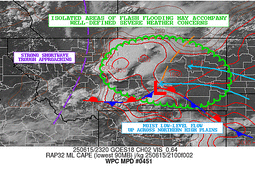
22z Update: Main change was to add a Marginal risk to portions of
southeast NM and southwest TX. High res guidance is under doing
the extent and magnitude of convection over this area. Wind
profiles support slow cell motions, which combined with the high
instability and moisture in place, supports a continued isolated
flash flood risk. See MPD #449 for more details.
Chenard
...Previous Discussion...
...Mid-Atlantic and Central Appalachians...
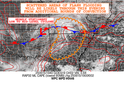
16Z Update: The previous MDT risk was maintained with some
expansion to the northwest to reflect the latest prob fields
highlighting a greater threat north of Richmond as convection fires
and slides down the instability gradient aligned with the front.
Biggest shift was the expansion of the SLGT a bit further north and
northwest into Southeast OH and more of Western PA as area 1/3/6 hr
FFG indices are incredibly low given the saturate grounds lingering
from yesterdays convective impacts. Environment in place is
conducive for locally enhanced rainfall rates with the stronger
cores more apt to produce intra-hour rates closer to 3"/hr with an
average 1-2"/hr intensity in any thunderstorm development. The area
over Northern and Eastern WV is also under a greater threat for
flash flooding today due to similar characteristics noted to the
north. Complexity of the terrain adds more opportunity for locally
significant flash flood concerns, something that has historical
precedence in these areas encompassing the Central Appalachian's.
In all, the setup remains on the higher end of the SLGT spectrum
for much of VA into WV and Southwest PA with a targeted MDT down
over Southern VA and the Tidewater due to the more robust PWAT
and instability signatures within the confines of quasi-stationary
front creating a greater threat for training convection.
Kleebauer
..Previous Discussion..
A back door cold front will continue to slow down its forward
progress and idle across the Mid-Atlantic region through Father's
Day. Moist southwesterly flow will intersect this boundary and
result in enhanced moisture convergence and lift. A combination of
ample instability on the order of 1000-2000 J/kg of mixed layer
CAPE, PWs nearing 2 inches, and a strong frontal boundary will set
the stage for additional heavy rain over grounds that are becoming
much more saturated leading up to this. There are two main areas of
increased concern, with the first being over eastern West Virginia
where HREF probabilities of flash flood guidance exceedance are
elevated due to antecedent conditions and the prospects of 1-2
inches of additional rain on Sunday. Although this area still
remains in a Slight Risk, there is the potential that an upgrade to
Moderate Risk may be needed once the event starts to materialize
midday Sunday, so this will continue to be closely monitored.
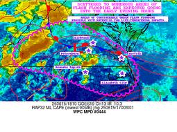
The other area of concern is across the Tidewater region of
southeast Virginia into adjacent portions of northeast North
Carolina. The 00Z CAM guidance strongly supports swaths of enhanced
QPF from just south of Richmond to the northern Outer Banks, and
rainfall totals on the order of 2-3 inches, and locally higher, are
expected. This would be falling on top of grounds that already had
1-3 inches on Saturday near the U.S. Highway 460 corridor into
Southside Hampton Roads, so that is an aggravating factor. All of
this combined with higher HREF flash flood guidance probs resulted
in areas south of the James River and north of the Albemarle Sound
to now be in a Moderate Risk for this time period.
Hamrick
...Mid-South to the ArkLaTex...
16Z Update: MCS currently migrating south across the Red River will
continue propagating towards Southeast TX before fizzling out on
approach once south of I-45. Current indications are a combination
of differential heating causing destabilization over Southeast TX
will initiate another round of pulse convection with the remnant
cold pool of the MCS eventually interacting with storms already in
the area. Some minor convergence signatures are popping up within
CAMs, but the threat seems to be relatively minor compared to
previous setups as the stable component behind the complex provides
a cap on the activity pretty quickly once the interaction occurs.
HREF probs are generally modest for >3" potential, but fall off a
cliff to near 0% for >5", so the realistic maximum is somewhere
between 3-5" with an areal average closer to 1-2" where convection
does occur. The greater convergence signature is up closer to the
Northwest Ozarks where satellite combos and even regional radar
composite depict a broad MCV slowly drifting eastward with the mean
flow leading to a small band of light/moderate rainfall in the
northern quadrant of the circulation.
The area to the southeast is the most prone to convective
initiation and relatively impacts due to the proxy and persistent
advection of moisture within the southeast and eastern flank of the
meso-low. Visible satellite indicates a broad area of clearing
which will likely enhance regional instability prospects given the
"green light" for diurnal destabilization pattern. CAMs are in
agreement on another round of heavy convection over the areas
outlined within the zone of clearing leading to elevated
neighborhood probs for >3" (50-70%) across Central and Northern AR
into Southeast MO. The former area has been hit multiple times over
the past 24-48 hrs leading to some priming of the soils so the
threat for flash flooding is a bit higher compared to Southeast MO.
Will need to monitor that region closely overnight to see how the
convective pattern evolves, but the previous SLGT risk inherited
was sufficient to warrant continuity as the setup has maintained
similar posture within the 12z CAMs suite and ensemble. The threat
over TX is still well within the MRGL threshold and given the cap
on potential, the risk was not upgraded as the threat remains more
localized with greatest potential in urbanized zones. Will monitor
the MCS evolution closely as any changes in the near term could
allow for a targeted upgrade, namely in the area along I-35.
Kleebauer
...Upper Midwest...
16Z Update: The signal for the SLGT is favorable on the threat as
most CAMs remain aggressive for the evening complex anticipated to
slide down the eastern flank of the theta_E ridge positioned over
the Plains. HREF EAS and neighborhood prob fields still highlight
that area of far Southeast SD, Northwest IA, and Southwest MN this
evening with the greatest chance for locally 2-4" of rainfall.
Considering the antecedent soil moisture being elevated after this
mornings convective impacts, the foundation was laid for a targeted
opportunity to see some localized flash flood prospects. This
allowed for little to no change in the previous forecast as the
threat is still on track.
Kleebauer
..Previous Discussion..
The expected convective complex over the Dakotas and moving into
Iowa will likely be more on the progressive side compared to the
MCS farther south across Arkansas. However, some of the heavier
rain that is expected will likely happen over more saturated soils
and therefore a higher chance of localized impacts. The 00Z CAM
guidance suite has trended wetter, especially the 3km NAM, and the
global guidance to include the GFS and the CMC also have a more
concentrated QPF signal. Therefore, northwestern Iowa and portions
of adjacent states are now in a Slight Risk area for this time
period.
Hamrick
Day 1 threat area:
www.wpc.ncep.noaa.gov/qpf/94epoints.txt
Excessive Rainfall Discussion
NWS Weather Prediction Center College Park MD
610 PM EDT Sun Jun 15 2025
Day 2
Valid 12Z Mon Jun 16 2025 - 12Z Tue Jun 17 2025
...A SLIGHT RISK OF EXCESSIVE RAINFALL EXISTS FOR PORTIONS OF THE
MID-ATLANTIC, CENTRAL APPALACHIANS, AND OHIO VALLEY...
...Mid-Atlantic to Central Appalachians...
20Z Update: Convective focus along a stalled quasi-stationary
front will lead to another period of locally heavy rainfall with
training potential existing over portions of North Carolina. The
setup is just a continuation of a broad convective regime with a
general alignment of stronger convection within the confines of a
front that will lie from Western PA down through Northern and
Eastern WV, Southwest VA, arcing back towards Eastern NC.
Relatively buoyant environment and elevated PWATs running +1.5 to
+2 deviations will be sufficient in producing local rainfall rates
between 1-2"/hr across much of the above zones with the Eastern NC
area more likely to see closer to 2-3"/hr in heavier cores as
projected within the latest hourly rate probs via the 12z HREF.
HREF blended mean QPF output is a general 0.5-1" in areal average
across Southwest PA down through Northern and Eastern WV, but
scattered deterministic signals of 2-3" are pretty common within
the latest suite. A more robust 1.5-2" areal average is positioned
from the NC Triangle across through Eastern NC with a general
maxima between RAH to Hatteras. The eastern fringes of the heavier
precip will be positioned over sandier soils leading to a naturally
lower probability for flash flooding compared to inland areas of
NC. Points north are a combination of low FFG's and complex terrain
that will likely cause some problems with almost any heavier QPF
core that materializes. Given the signatures above, and a forecast
SLGT from the recent First Guess Fields in the interior Mid
Atlantic, a SLGT risk upgrade was generated for the D2 forecast
with a footprint extending from just east of RAH along I-40 and
points northwest up through Southwest VA, Northern and Eastern WV,
and Western PA.
Kleebauer
...Ohio Valley...
20Z Update: A persistent MCV will create an environment favorable
for locally heavy rainfall across portions of the Mid-Mississippi
Valley into the Ohio Valley. Area convergence under the general
circulation from the remnant complex will create a zone of enhanced
precip potential with most of the CAMs indicating the area from
far Western KY through the Ohio River Basin encompassing
IL/IN/KY/OH with the magnitude of heavier totals between 2-4". 12z
HREF neighborhood probs for >3" is pretty high (40-70%) along that
corridor of the Ohio River with the maximum depiction between that
intersection of IL/IN/KY. This is the general location of the
circulation when you assess the 500mb vorticity panels, so it makes
sense synoptically that the threat would converge over the
strongest mid-level ascent focus. FFG's are relatively modest
overall, but with 1-2"/hr rate potential in any cell development,
this would be sufficient to exceed the hourly FFG's currently, but
the biggest signal comes from the 3hr FFG exceedance probability
with the latest ensemble output showing 30-50% chances for several
3hr increments between 12-00z tomorrow. A targeted upgrade to a
SLGT risk is now in place over the aforementioned region for the
threat of flash flooding under the guide of a remnant MCV/low-
amplitude shortwave moving from the Mid-Mississippi Valley into
the Western Ohio Valley.
Kleebauer
...Dakotas to the western Great Lakes...
20Z Update: Little to no adjustment was necessary for the broad
MRGL risk as the previous forecast remains steadfast in its
presentation for locally heavy rainfall across the Upper Midwest
into parts of the Northern Plains. The heaviest rain is still
forecast to occur in the heart of the Sandhills of NE, an area that
will likely be void of many flash flood concerns due to the soil
composition and very high FFG's in place.
Kleebauer
..Previous Discussion..
Consensus for locally heavy rainfall across portions of the
Northern tier of the CONUS remains favorable across a broad area
extending through the Dakotas, Nebraska, and the Upper Midwest on
Monday. It remains the case that some of the heavier rainfall is
expected over the Sandhills of Nebraska where flash flood guidance
is high, and therefore not rising to the level needed for a Marginal
Risk in that area. Elsewhere, there remains a scattered heavy rain
threat over the northern portions of the Upper Midwest at this
time, and therefore a Marginal Risk remains valid there.
Hamrick
Day 2 threat area:
www.wpc.ncep.noaa.gov/qpf/98epoints.txt
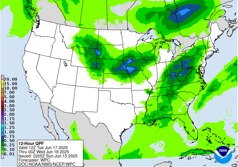
Excessive Rainfall Discussion
NWS Weather Prediction Center College Park MD
610 PM EDT Sun Jun 15 2025
Day 3
Valid 12Z Tue Jun 17 2025 - 12Z Wed Jun 18 2025
...THERE IS A SLIGHT RISK OF EXCESSIVE RAINFALL ACROSS PORTIONS OF
THE MIDWEST, EASTERN OHIO VALLEY, AND CENTRAL APPALACHIANSâ
...Midwest...
20Z Update: The previous forecast SLGT was general maintained with
some expansion of the risk area to the southwest given the latest
trends slowly shifting the threat more into Northwestern MO and
far Northeast KS. The latest ML output is also leaning towards the
southern end of the envelope when it comes to the heaviest QPF
distribution, so it's plausible the shifts will continue to trend
more into the I-70 corridor across KS/MO if this holds. For now,
wherever the threat materializes, there will be heavy rain with
totals likely between 3-5" in the hardest hit areas. Some training
potential is plausible considering the upwind trajectory behind the
vacating surface low as it cuts to the northeast. Will be
monitoring closely for both the positioning of the risk, and a
potential for a targeted upgrade if the magnitude of the precip
forecast increases, or focuses over some of the larger urban
corridors where flash flood potential is most likely. A higher end
SLGT is certainly forecast at this juncture.
Kleebauer
..Previous Discussion..
A well organized mid-upper level shortwave trough will eject
eastward from the Rockies to the central Plains Tuesday afternoon
into the early hours of Wednesday morning, and this will sustain
the development of a surface low that will develop along a frontal
boundary. Upper level dynamics will be favorable as the region will
be place under the right entrance region of the main upper level
jet, and incoming mid-level positive vorticity advection will
further aid ascent. Precipitable water values in the warm sector of
this surface low are expected to rise into the 1.75 to 2 inch
range and an increasing southwesterly low level jet that will
advect copious moisture into the system.
Model guidance has trended a little to the south over the past few
model cycles, with the greatest consensus for the heaviest QPF
across the southern half of Iowa and over the northern third of
Missouri, and extending to northeast Kansas and west- central
Illinois. Most model solutions have a broad corridor of 1-2 inches
with embedded 3-4 inch maxima within this region, with the majority
of this happening within the 18Z Tuesday to 6Z Wednesday time
period. The heavy rain that fell across portions of the Upper
Midwest is generally north of where this expected rainfall will be,
so grounds will not be saturated in most cases leading up to this
event. The inherited Slight Risk from the previous Day 4 outlook
will be maintained with a southward expansion to it, and a broader
Marginal Risk extending across South Dakota and eastward to include
the greater Chicago metro area.
Hamrick
...Ohio Valley and Central Appalachians...
20Z Update: The threat for a broader impact flash flood threat is
increasing as we move into Tuesday afternoon and evening before we
finally end the incessant heavy rain pattern generated by scattered
to widespread convection across parts of the Eastern Ohio Valley
into Western PA and the adjacent Appalachians. The upper pattern
will be a significant driver in the area precip coverage as we move
into Tuesday with large scale forcing on the rise as we see an
approach of a potent shortwave trough out of the Ohio Valley. Area
moisture field will be running ~2 deviations above normal with
forecast PWATs between 1.7-2" likely across much of Ohio, Eastern
KY, WV, and the western half of PA. The combination of a stagnant
elevated moisture regime and plentiful forcing will generate a
period of scattered to widespread thunderstorm activity migrating
across the above areas creating a heightened threat of flash
flooding when you take into consideration the compromised soils
from all the rainfall leading into the setup. The area of Northern
WV, Western PA, and Eastern Ohio is by far the most sensitive in
this pattern and the threat for heavy precip is as genuine as you
can get, in a synoptic sense. Ensemble depictions of 1-1.5" areal
average at a D3 lead is a testament to the threat and has a lot of
support from the QPF distribution within the latest ML consensus.
For now, a SLGT risk was introduced to encompass that corridor
referenced above in the Ohio Valley up through Western PA. If this
trend becomes more favorable in the QPF maxima exceeding 3" across
some of those more compromised areas, a further targeted upgrade is
plausible. This is a setup to monitor closely over the coming days.
Kleebauer
Day 3 threat area:
www.wpc.ncep.noaa.gov/qpf/99epoints.txt
Extended Forecast Discussion
NWS Weather Prediction Center College Park MD
300 PM EDT Sun Jun 15 2025
It still remains the case that highly unsettled weather will remain
in the forecast from portions of the east-central to eastern U.S.
into mid-later week as an upper-wave/associated surface frontal
system pushes eastward with deepened moisture in place. On
Wednesday (Day 4), widespread convection is expected along and
ahead of surface low pressure and a trailing cold front through the
Great Lakes/Midwest southwest through at least the Mississippi
Valley and possibly into the southern Plains. The storms,
potentially organized, will be capable of producing locally heavy
rainfall with guidance QPF signals of 1-3"+. A Marginal Risk ERO
remains across the region and it is likely a more focused corridor
of higher risk will be needed once there is more certainty in the
areal placement. In addition to heavy rainfall/flash flooding, the
Storm Prediction Center has also highlighted a severe weather risk
as moderate instability and sufficient shear will bring the threat
for large hail and damaging winds, particularly with any organized
convective lines. The focus for storms will shift eastward with
the system on Thursday (day 5) with another Marginal Risk ERO
stretching along/near the cold front from northern New England and
the Interior Northeast southwest through the Appalachians into
portions of the Tennessee Valley. Additional scattered storms will
be possible ahead of the cold front across the Mid-Atlantic and
through portions of the Southeast/Lower Mississippi Valley
Wednesday-Thursday. Storm/rainfall focus Friday-Sunday should
shift southward with the cold front to the Gulf Coast/Florida, as
well as along the northern tier from the Upper Midwest/Great Lakes
to the Interior Northeast as the storm track lifts northward. A
signal also remains for a multi-day enhanced tropical moisture feed
from the Gulf to northeast Mexico and South Texas/West Gulf Coast
with the potential for locally heavy rainfall. A Day 5/Thursday ERO
Marginal Risk area has been introduced to address this potential.
Upstream, the energetic approach of a deep upper-trough/Pacific
system and northern stream energies into the West look to bring
colling temps and increasing precipitation chances to the Pacific
Northwest by Friday and across with northern Rockies/High Plains
next weekend in unsettled flow with moderate rainfall potential.
Expect a focus for above average temperatures across the
Intermountain West/Southwest early to mid-next week to shift into
the central Plains and the Middle/Upper Mississippi Valley by late
next week as a strong upper-ridge begins to build in bringing
heat/muggy conditions to start the Summer. The heat will also begin
to intensify across the Lower Mississippi Valley and Southeast as
well as the upper-ridge intensifies eastward. Forecast heat indices
late next week/weekend range from 95-100 across the central Plains
to Middle/Upper Mississippi Valley, 95-100 across the Southeast,
and 105-110+ for the Lower Mississippi Valley and Gulf
Coast/Florida. Hotter temperatures/muggy conditions are also
expected from the Ohio Valley east into the Mid-Atlanitc during the
middle of next week before a cold front passage brings relatively
more comfortable conditions late next week/weekend. Highs will
begin to trend cooler and below average by as much as 10-15 degrees
across portions of the Northwest by Friday and expand into the
Great Basin/northern Rockies by the weekend as an upper-trough and
associated surface cold front from the northeast Pacific begin to
overspread the region.
Schichtel/Putnam


