Excessive Rainfall Discussion
NWS Weather Prediction Center College Park MD
348 PM EDT Fri Jun 13 2025
Day 1
Valid 16Z Fri Jun 13 2025 - 12Z Sat Jun 14 2025
...A SLIGHT RISK OF EXCESSIVE RAINFALL EXISTS FOR PORTIONS OF THE
MISSISSIPPI VALLEY, NORTHWEST GULF COAST, & SOUTHERN MID-ATLANTIC
STATES...
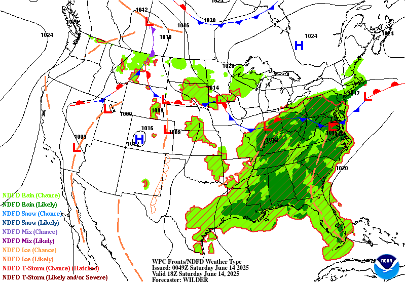
...Mid-Atlantic...
Stalled frontal boundary stretching across the Delmarva Peninsula
towards the Upper Ohio Valley will combine with increasing
atmospheric moisture content (1.5-2.0" PWs by this evening) to
create efficient rainfall rates within thunderstorms. The southerly
mid-level flow will be aided by an upper low currently analyzed
over southern MO, but with troughing stretching from the Midwest to
the western Gulf. Convection is most likely to trigger first
across the Carolinas and the elevated terrain of the Blue Ridge up
through the central Appalachians. Mean column wind speeds of 20 kts
out of the west should promote some propagation of storms,
especially once a cold pool is established, but complex terrain and
areas right along the frontal boundary could exhibit some training
potential along with rainfall rates up to 2"/hr. The inherited
Slight Risk was maintained and expanded a bit westward to encompass
more of the sensitive Blue Ridge mountains of central/northern VA.
12z HREF guidance depicts 30-50% chances for 3" totals within 6
hours this evening across central VA. This along with the available
moisture content and nearby frontal boundary support the potential
for scattered instances of flash flooding and the potential for
localized considerable impacts in the sensitive terrain near the
Blue Ridge as well as urban locations between southern MD and
northeast NC. However, some guidance (including the 12z HRRR and
experimental 06z RRFS) are mostly void of excessive rainfall
coverage, which does prompt some uncertainty during the D1 period.
...Mid-Mississippi Valley and Lower Ohio Valley...
The inherited Slight risks were consolidated to focus on the
eastern and southern flanks of the mid-level low churning over the
region. Isolated flash flooding is still possible across parts of
central MO/IL underneath and near the low center, but coverage of
heavy rain does not seem widespread enough to warrant a Slight
Risk. Moisture and effective bulk shear will be plentiful across
much of the Mid-Missippi Valley and lower Ohio Valley while ML
CAPE will be sufficient for organized convection in a number of
areas. PW values of 1.75-2.0" will near the 90th climatological
percentile per the 00z ECENS. The risk percentage for AR is in
decline as the heavy rain signal appears better elsewhere, but
lowish flash flood guidance and the Ozarks should prove sufficient
for widely scattered to scattered flash flood concerns, especially
given the potential for storms to re-ignite late tonight under the
influence of an increasing low-level jet. Flash flood guidance is
many ares appears compromised by recent rainfall (during the past
week). Overall, the expectation is for isolated to scattered
instances of flash flooding and the greatest concern located within
urban and poor drainage locations.
...Northwest Gulf Coast...
Showers and thunderstorms are forecast to retrograde from southwest
LA across sensitive areas of Southeast TX this morning within an
area of low- level convergence and retreating/eroding instability.
This occurring after extreme rainfall amounts (7"+) impacted
south-central LA early this morning. Additional hourly rain
amounts to 2.5" with local totals to 5" are probable along the
northwest Gulf Coast due to sufficient effective bulk shear,
moisture, and instability, which would be most problematic where it
rained heavily on Thursday and within urban areas. 12z HREF
probabilities for greater than 5" in 6 hrs are 15-20% and scattered
throughout the region.
...Texas Panhandle and Caprock Region...
Dryline convection this evening is expected along much of the High
Plains, but also as far south as the Texas Panhandle and western
Texas where 1-1.25" PWs remain. 3-hr FFGs in the region are below
3" and have been somewhat wet as of the last month (100-200% of
normal for some locations). A Marginal Risk was added given the
potential for numerous thunderstorms, while progressing eastward
steadily, could merge and lead to brief periods of training.
...Northern WI/Michigan U.P....
Area of low pressure moving eastward through MN helps drive a
risk for heavy rainfall within narrow bands from MN across
northern WI Friday morning. Instability appears sufficient in spots
(500+ J/kg of MU CAPE) for pockets of organized convection capable
of heavy rainfall, but isentropic lift/low- to mid-level
frontogenesis is expected to aid heavy rainfall production as well.
Hourly amounts to 1.5" with local amounts to 3" are possible where
cells train. The inherited Marginal Risk was shrunk based on radar
and latest CAM trends.
...Northern Rockies/Western High Plains...
The Marginal Risk across Montana maintained along the western
interface of the deeper moisture and instability over much of the
Plains on the leading edge of a quasi-stationary upper level trough.
Snell/Roth
Day 1 threat area:
www.wpc.ncep.noaa.gov/qpf/94epoints.txt
Excessive Rainfall Discussion
NWS Weather Prediction Center College Park MD
348 PM EDT Fri Jun 13 2025
Day 2
Valid 12Z Sat Jun 14 2025 - 12Z Sun Jun 15 2025
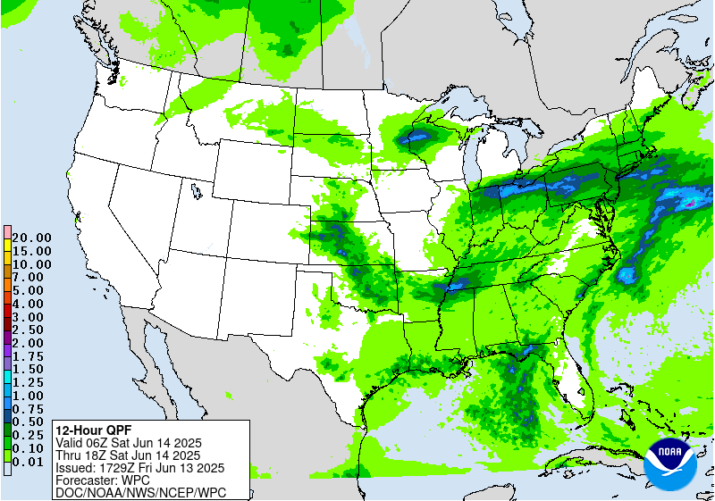
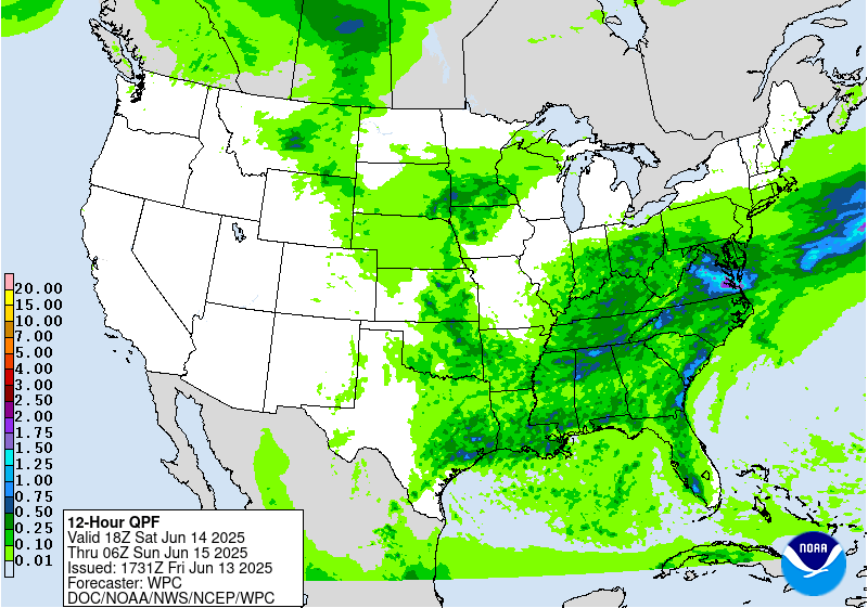
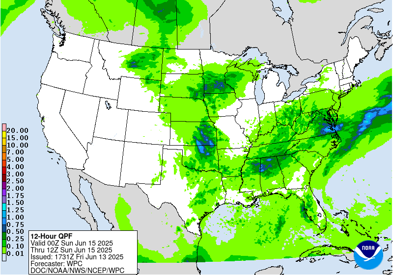
...THERE IS A SLIGHT RISK OF EXCESSIVE RAINFALL FOR CENTRAL/EASTERN
VIRGINIA & ACROSS PORTIONS OF EASTERN KANSAS/OKLAHOMA...
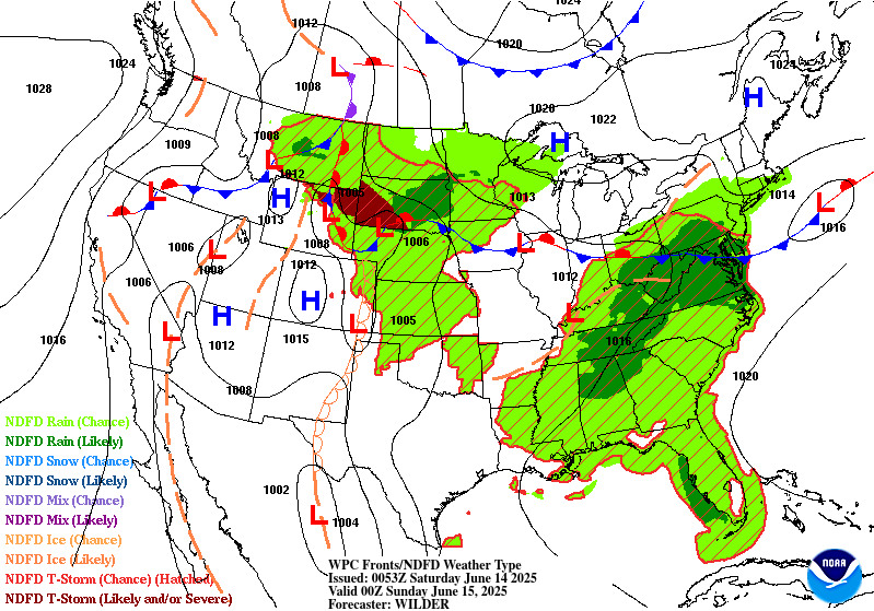
...Mid-Atlantic...
Along a stationary front, another day of high moisture, sufficient
instability and effective bulk shear team up for heavy rainfall in
Virginia and specifically focus near southeast Virginia as the
front slides south by the evening hours. Widespread light to
locally moderate rainfall across the northern Mid-Atlantic should
tighten the thermal gradient in the region and potentially provide
a better focus for storms compared to Day 1. PWs are forecast to
remain near 2" and around the 90th climatological percentile. CAMs
depict widespread amounts of 2-4" possible with localized totals
potentially exceeding 5" (12z HREF probs for greater than 5" are
20-40%), with the greatest potential in southeast Virginia. Urban
areas and places with increasing soil saturation due to the
previous day of heavy rainfall would be most at risk for issues.
...Southern Plains, Southeast, and Tennessee/Ohio Valleys...
A deep layer cyclone drops southeast from IL into KY with time.
The system remains quite moist with sufficient effective bulk shear
along and near its associated fronts with greater instability,
particularly across portions of the Plains as mid-level capping is
increasing due to a strengthening 500 hPa ridge across NM, though
the cap is breakable especially near remnant MCVs from overnight
convection ejecting from the High Plains D1. Because of this
greater instability, a few pieces of guidance are quite wet
somewhere in the neighborhood of OK and KS, especially the 12z NAM,
00z CMC, and several CAMs showing maxima of 5-13". Hourly rain
amounts to 2.5" appear likely in this environment. Cell training
due to storms moving south- southeast down the stationary
instability gradient would be problematic if it occurs within a
long enough band over several hours. The inherited Slight Risk was
maintained with only minor adjustments. Should guidance converge
on wet solutions, further upgrades could occur.
Closer to the deep layer cyclone churning over the Ohio Valley,
slow moving convection and brief organized training is possible.
A more cellular convective mode is likely near the cyclone over the
Ohio Valley, where isolated flash flooding could occur. Along the
southern flanking inflow band, mean wind becomes more westerly and
parallel to developing convection across central and northern
AL/MS. This is an area that could warrant an upgrade to a Slight
Risk if more confidence arises in better convective organization
conducive for scattered flash flooding. At the moment, more
isolated and localized flooding is more probable.
...In and near the Iowa/Minnesota border...
A warm advection pattern returns to the region, bringing
precipitable water values up to 1.75" and sufficient effective bulk
shear and instability for organized convection. After rainfall on
Thursday and Friday, soils should be increasingly saturated/
compromised at this point. However, the guidance spread on the
heavy rain signal is quite large...best across southeast SD and
southern MN. While increasing warmth at 700 hPa is seen across the
central High Plains, any mid-level capping should be minimal.
However, the broad reservoir of instability to the southwest could keep
southward shifts in the guidance minimal between now and when the
convection materializes on Saturday. Hourly amounts to 2" and
local totals to 4" are possible, given the available ingredients
and potential lingering MCV to move eastward into the region from
D1. This could be from a combination of cell training and
occasional mesocyclone formation. The degree of the flash flood
threat would depend on whether or not urban centers received this
heavy rainfall or if/where soils were sufficiently compromised over
previous days within impacted areas.
Snell/Roth
Day 2 threat area:
www.wpc.ncep.noaa.gov/qpf/98epoints.txt
Excessive Rainfall Discussion
NWS Weather Prediction Center College Park MD
348 PM EDT Fri Jun 13 2025
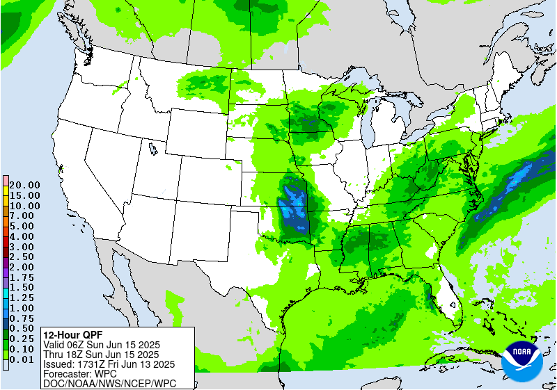
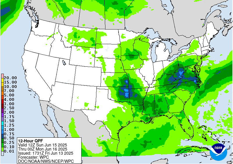
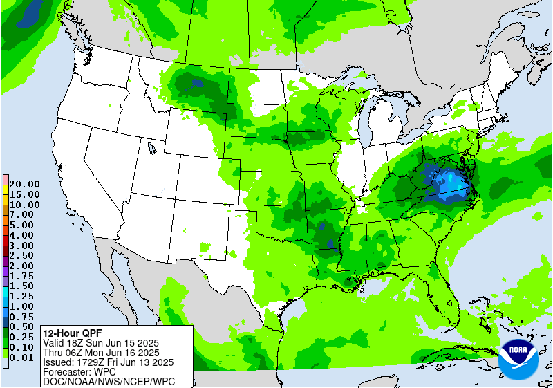
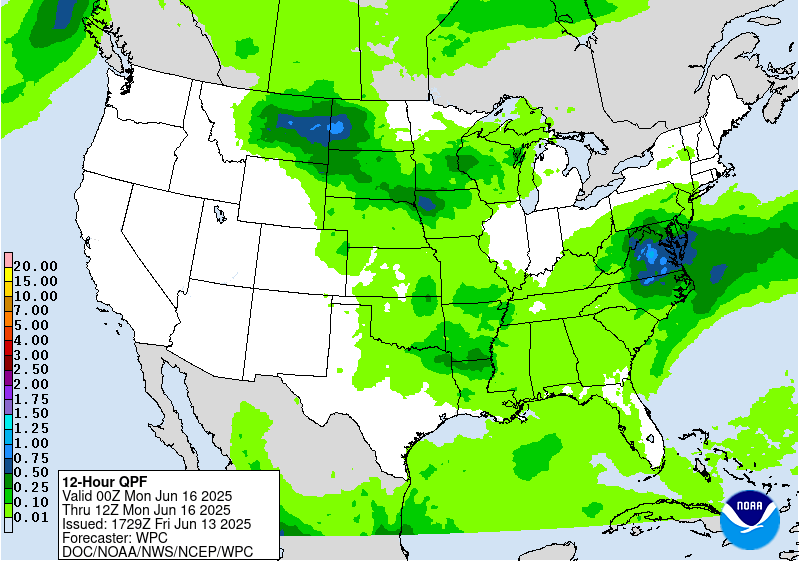
Day 3
Valid 12Z Sun Jun 15 2025 - 12Z Mon Jun 16 2025
...A SLIGHT RISK OF EXCESSIVE RAINFALL EXISTS FOR MUCH OF VIRGINIA
AND INTO PARTS OF THE CENTRAL APPALACHIANS...
...Southern Mid-Atlantic States and Central Appalachians...
Another round of organized convection within a very moist
environment with sufficient effective bulk shear and instability is
expected near a stationary boundary. Like previous days, hourly
rain amounts to 2.5" with local amounts to 5" are possible.
However, by Sunday the influence of a strung-out upper low will
near the region and provide better forcing for greater coverage in
moderate to heavy rainfall. The previous Slight Risk was expanded
westward in order to encompass more of WV and western VA to account
for the heavy rain potential in sensitive terrain of the central
Appalachians on the western slopes given predominantly west-
southwesterly flow. Once again, flooding impacts will be
exacerbated in urban centers and what should be increasingly
saturated soils due to expected rainfall on Friday and Saturday.
Outside the CAM range for this outlook, but most global guidance
suggests at least 2-3" totals are likely to be common within the
Slight Risk. Given the potential soil sensitivity in this region
and the expected coverage of convection by Day 3, further upgrades
may be necessary.
...Northern Plains into the Midwest and Lower Mississippi Valley...
A "ring of fire" type of setup appears to be in the offing for
this region as ridging continues to build across NM, upper
troughing remains stagnant across the Pacific Northwest, and the
deep layer cyclone moves from KY towards WV. Temperatures at 700
hPa continue to warm somewhat across portions of the Rockies and
the central High Plains, strengthening the mid-level capping
inversion and increasing the instability available/forward
propagation odds for any organized convective complex that forms
around the ridge's periphery. The region with the highest heavy
rain potential appears to be from the southern Plains/Midwest
southeastward near a possible Mesoscale Convective System. There is
significant model spread on location, keeping the risk level as
Marginal at this time. However, higher end potential exists for any
convection that can train along the instability gradient from
roughly eastern KS through AR, as seen in different ways on the
global solutions and experimental RRFS which show local maxima in
the 4-7" range. Should the guidance converge, an increased threat
level could be prudent.
Snell/Roth
Day 3 threat area:
www.wpc.ncep.noaa.gov/qpf/99epoints.txt
Extended Forecast Discussion
NWS Weather Prediction Center College Park MD
300 PM EDT Fri Jun 13 2025
It generally remains the case that highly unsettled weather will
remain in the forecast across much of the central/eastern U.S.
throughout next week as numerous expected embedded impulses in the
upper-levels override frontal boundaries with seasonable moisture
in place. Uncertainty remains with the specific day-to-day details
given the short-wave energies, frontal placement, and likely
mesoscale boundaries from prior days' storms driving new
development each day, but a few more focused corridors are
apparent. First, another round of thunderstorms is expected through
portions of the Mid-Atlantic Monday (day 4) as a quasi- stationary
boundary remains draped through the region and precipitable water
values remain high. While storm coverage/rainfall amounts look to
be lower compared to prior days, wet antecedent conditions and
potential for additional storms support maintaining a Marginal Risk
in the day 4 ERO that has been shifted to the south given latest
guidance trends. Another focus will be across the Northern
Plains/Upper Midwest with daily thunderstorm chances along a couple
frontal boundaries. A Marginal Risk has been maintained for the
day 4 period with areas of moderate to locally heavy rainfall
expected throughout the region. Then, on Tuesday (day 5), a greater
threat is apparent across portions of the Upper Midwest as QPF
shows the potential for several inches of rainfall with more
widespread/potentially organized convection, and a Slight Risk ERO
has been shifted slightly southward. This region will have also
experienced several days of rainfall prior to the day 5 period, so
antecedent conditions should remain wet. Storms in this region may
also bring an ample severe weather risk as per SPC, including the
potential for damaging winds with any organized convection. Expect
the focus for storms will begin to shift south and eastward
Wednesday- Friday with eastward movement of upper-
troughing/associated surface frontal boundaries and upper- level
ridging beginning to build in over the central U.S. There are also
growing signals for an enhanced tropical moisture feed from the
Gulf to northeast Mexico and South Texas in a week to monitor for
signs of system development out from the Bay of Campeche/vicinity.
Expect above average temperatures across the Intermountain West
and adjacent portions of the Plains and Southwest to persist
through next week with mean upper-ridging in place. Some more
locally intense heat is apparent across portions of the Southwest
into the southern High Plains Monday-Tuesday as highs rise into the
low to mid-100s. Temperatures will generally remain near late
Spring/early Summer averages across the eastern U.S. early next
week with unsettled conditions given the upper-flow pattern. Some
cooler, below average temperatures are forecast on Monday for the
Mid- Atlantic region as the area remains to the north of a
lingering frontal boundary. Then, during mid- to late next week,
the pattern will begin to become more amplified, with the storm
track lifting north and upper-ridging beginning to build in from
the central to eastern U.S. Conditions look to become increasingly
hotter/muggier from the Plains east through the Mississippi/Ohio
Valleys and into the Southeast/Mid-Atlantic. Forecast heat indices
are over 100 for much of the region, with heat indices over 105
most likely for the Gulf Coast, the Lower Mississippi Valley, and
along the Eastern Seaboard north through the Carolinas and into the
southern Mid- Atlantic.
Schichtel/Putnam


