Extended Forecast Discussion
NWS Weather Prediction Center College Park MD
259 AM EDT Fri Jun 13 2025
Valid 12Z Mon Jun 16 2025 - 12Z Fri Jun 20 2025
...Heavy rain/flash flood threat from the south-central U.S. to
the Tennessee/Ohio Valleys and Mid-Atlantic Sunday to Monday...
...Multi-day Heavy Convective Rainfall threat for the northern
Plains/Upper Midwest next week...
...Southwest High Heat in to early next week and a hot/humid
airmass for the South next week...
...General Overview...
Unsettled weather is expected across much of the central/eastern
U.S. next week as upper-level energies in a split stream pattern
override frontal boundaries with seasonable moisture available.
More focused corridors of moderate to locally heavy rainfall are
forecast across the Mid-Atlantic Monday, and the northern
Plains/Upper Midwest Monday into Tuesday. A flash flood/severe
weather threat is apparent across this region. Summer-like heat
will greet portions of the Southwest to start the week, with
gradually increasing hotter/muggier conditions from the south-
central to Southeast U.S. mid- to late next week. There is a signal
for an increase in tropical moisture/associated rainfall into the
south-central U.S. late next week.
...Guidance/Predictability Assessment...
Updated 12/18Z guidance at the start of the period early next week
(Monday June 16) shows a complex and active split stream pattern
over the central/eastern U.S. that is agreeable on continued
unsettled weather but with expectantly less clarity in the day-to-
day details. Both a southern stream upper-level shortwave over the
south-central/southeastern U.S. riding along/north of the
southwestern Atlantic ridge and a northern-stream shortwave over
the northern Plains/Upper Midwest look to be followed by and/or
reinforced by additional energies upstream. The upper-level
shortwave in the southern stream looks most likely to more quickly
shear out based on the GFS/UKMET while the CMC/ECMWF show more
support for longer lasting/reinforced energy lifting northeastward,
with associated QPF impacts. An upper-low anchored over the
northeastern Pacific looks to be the source of some of these
additional energies, and guidance has come into better agreement
(GFS/ECMWF/CMC) with one particular upper- wave upstream over the
western U.S. moving quickly eastward over the central U.S. by mid-
week and Midwest/Northeast/southeastern Canada late week. Prior
runs had shown a split in the energy, with a progressive part in
the northern stream and lingering/much slower energy over the
southwestern to south-central U.S. in the southern stream. A shift
to a more amplified pattern is apparent across the deterministic
and mean guidance late next week following the departure of this
last upper-wave. Broader mean ridging begins to build over the
central to southeastern U.S. as the deep, upper- level low that had
been lingering over the northeastern Pacific begins to shift
southward and overspread the northwestern U.S. The updated WPC
forecast begins with a composite blend of the deterministic
guidance given generally good agreement and no strong clustering
around any specific detail. The UKMET is then removed mid-period as
its depiction of the noted upper-wave mid-week differs from the
other guidance. Contributions from the GEFS/ECens means are
included and increased in the mid- to late period as uncertainty in
the forecast grows. The greatest adjustment in the resultant
forecast is to focus/maintain the noted upper- wave/associated
surface frontal system from the central to eastern U.S. mid- to
late next week.
...Weather/Hazards Highlights...
Unsettled weather will remain in the forecast across much of the
central/eastern U.S. throughout next week as numerous expected
embedded impulses in the upper-levels override frontal boundaries
with seasonable moisture in place. Uncertainty remains with the
specific day-to-day details given the short-wave energies, frontal
placement, and likely mesoscale boundaries from prior days' storms
driving new development each day, but a few more focused corridors
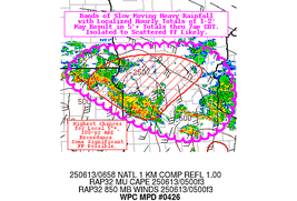
are apparent. First, another round of thunderstorms is expected
through portions of the Mid-Atlantic Monday (day 4) as a quasi-
stationary boundary remains draped through the region and
precipitable water values remain high. While storm
coverage/rainfall amounts look to be lower compared to prior days,
wet antecedent conditions and potential for additional storms
support maintaining a Marginal Risk in the day 4 ERO. Another focus
will be across the Northern Plains/Upper Midwest with daily
thunderstorm chances along a couple frontal boundaries. A Marginal
Risk has been maintained for the day 4 period with areas of
moderate to locally heavy rainfall expected throughout the region.
Then, on Tuesday (day 5), a greater threat is apparent across
portions of the Upper Midwest as QPF shows the potential for
several inches of rainfall with more widespread/potentially
organized convection, and a Slight Risk ERO has been introduced.
This region will have also experienced several days of rainfall
prior to the day 5 period, so antecedent conditions should remain
wet. Storms in this region may also bring a severe weather risk,
including the potential for damaging winds with any organized
convection. Thereafter, expect the focus for storms will begin to
shift south and eastward Wednesday-Friday with eastward movement of
upper- troughing/associated surface frontal boundaries and upper-
level ridging beginning to build in over the central U.S. There are
also growing signals for an enhanced tropical moisture feed from
the Gulf to northeast Mexico and South Texas in a week to monitor
for signs of system development out from the Bay of
Campeche/vicinity.
Expect above average temperatures across the Intermountain West
and adjacent portions of the Plains and Southwest to persist
through next week with mean upper-ridging in place. Some more
locally intense heat is apparent across portions of the Southwest
into the southern High Plains Monday-Tuesday as highs rise into the
low to mid-100s. Temperatures will generally remain near late
Spring/early Summer averages across the eastern U.S. early next
week with unsettled conditions given the upper-flow pattern. Some
cooler, below average temperatures are forecast on Monday for the
Mid- Atlantic region as the area remains to the north of a
lingering frontal boundary. Then, during mid- to late next week,
the pattern will begin to become more amplified, with the storm
track lifting north and upper-ridging beginning to build in from
the central to eastern U.S. Conditions look to become increasingly
hotter/muggier from the Plains east through the Mississippi/Ohio
Valleys and into the Southeast/Mid-Atlantic. Forecast heat indices
are over 100 for much of the region, with heat indices over 105
most likely for the Gulf Coast, the Lower Mississippi Valley, and
along the Eastern Seaboard north through the Carolinas and into the
southern Mid- Atlantic.
Putnam
Additional 3-7 Day Hazard information can be found on the WPC
medium range hazards outlook chart at:
https://www.wpc.ncep.noaa.gov/threats/threats.php
WPC medium range 500mb heights, surface systems, weather grids,
quantitative precipitation forecast (QPF), excessive rainfall
outlook (ERO), winter weather outlook (WWO) probabilities, heat
indices, and Key Messages can be accessed from:
https://www.wpc.ncep.noaa.gov/medr/5dayfcst500_wbg.gif
https://www.wpc.ncep.noaa.gov/medr/5dayfcst_wbg_conus.gif
https://www.wpc.ncep.noaa.gov/5km_grids/5km_gridsbody.html
https://www.wpc.ncep.noaa.gov/qpf/day4-7.shtml
https://www.wpc.ncep.noaa.gov/#page=ero
https://www.wpc.ncep.noaa.gov/wwd/pwpf_d47/pwpf_medr.php?day=4
https://www.wpc.ncep.noaa.gov/heat_index.shtml
https://www.wpc.ncep.noaa.gov/#page=ovw


