Excessive Rainfall Discussion
NWS Weather Prediction Center College Park MD
1140 AM EDT Sat Jun 14 2025
Day 1
Valid 16Z Sat Jun 14 2025 - 12Z Sun Jun 15 2025
...THERE IS A SLIGHT RISK OF EXCESSIVE RAINFALL FOR PORTIONS OF
THE MID ATLANTIC, SOUTHERN PLAINS, AND LOWER MISSISSIPPI VALLEY...
...Mid-Atlantic...
16Z Update: The setup remains conducive for locally heavy rainfall
across a good chunk of the Central Mid Atlantic today. Environment
is sufficiently buoyant with the 12z KIAD profile indicating
significant saturation from the surface to the tropopause. Sounding
revealed a PWAT output of 2.01", putting it above the 90th
percentile for the day and even above the climatological 30-day
moving max (99th percentile) for the period. Quasi-stationary front
will waver this morning and early afternoon before a slow
advancement south through the Piedmont down into VA by later this
afternoon and evening. Local MUCAPE forecasts between 1500-3000
J/kg will be plentiful for maintaining a strong instability regime
capable of enhancing any convective flare ups leading to heavy rain
prospects within any cell that initiates.
Biggest trend in the setup is a more robust convective depiction
over the Laurels down through the Potomac area, including the WV
Panhandle, Northern Neck of VA, DC metro, and NoVA. This aligns
within the confines of the surface frontal progression, outlined
decently in the theta_E field when looking at the latest CAMs. A
quick 2-4" of rain with locally up to 4" are plausible in the
above zone with a maxima of closer to 6" possible over Southeast VA
where a stronger convergence pattern and potential training is
forecast with an alignment of the mean wind along the front once it
reaches a latitude south of the line from
Harrisonburg/Fredericksburg/St. Mary's. Greatest threat for
significant flooding will reside just south of that line putting
more prone areas in Southern/Southeast VA under a threat for
enhanced flash flood concerns.
The main change was the adjustment of the SLGT risk further
northwest to encompass the expected zone of greatest convective
coverage with a high-end SLGT worded for the areas referenced above
with greater inclusion of portions of NoVA.
Kleebauer
..Previous Discussion..
An unsettled weather pattern continues across much of Virginia and
extending into adjacent portions of eastern West Virginia and
northeast North Carolina going into Saturday and Saturday night.
Multiple rounds of slow moving showers and thunderstorms will
develop generally along and ahead of a cold front that is gradually
settling to the south across Virginia. This boundary is
intercepting an anomalously moist airmass with PWs on the order of
1.75 to 2 inches and mixed layer CAPE on the order of 1000 J/kg on
average. The band of highest QPF is expected to be from the
northern Shenandoah Valley to the Hampton Roads area of Virginia,
with 2 to locally 4-6" inches of rainfall possible. Slow cell
motions and efficient rainfall could result in some hourly rainfall
rates approaching 2 inches per hour, especially where cell mergers
occur. This could result in some instances of flooding, especially
across urban locations and also areas that had heavy rainfall
through the early morning hours Saturday.
Hamrick
...Southern Plains, Southeast, and Tennessee/Ohio Valleys...
16Z Update: Our broad MCV over KS/OK is maintaining a signature of
persistent rainfall with embedded convective clusters capable of a
quick 1-2" of rain with some locally high amounts possible. This
threat will continue for a few more hours before the remnant cold
pools end up thwarting the maintenance of the convective regime
and fizzling out to mere lingering showers as we move through the
afternoon. The persistent circulation with the MCV will meander
across the Plains with an redevelopment of convective activity
after 00z as the nocturnal LLJ kicks back in and we see general
destabilization aid in the process of reigniting the pattern over
basically the same area. A one-two punch from this mornings
activity and this evening will be enough to enhance some flash
flood prospects within the overlapped zone across Southern KS into
Northern and Northeast OK where 12z HREF blended mean QPF is
signaling a broad area of 2-3" of rainfall with HREF neighborhood
probs for >5" running between 20-35% across portions of Eastern OK.
Considering the FFG's in place, this would prompt a better risk for
flash flooding given the priming and then secondary development
later this evening. The previous forecast for the SLGT was
relatively maintained with some expansion to account for QPF trends
within the latest CAMs and associated prob fields.
SLGT risk was expanded through AR into Northern MS and the far
southwest corner of TN to account for another zone of elevated impact
later this afternoon and evening as convection fires along a
lingering surface trough/quasi-stationary boundary on the
southwestern flank of the departing trough situated to the north-
northeast. Shortwave progression over the Plains will allow for
enhanced diffluent flow across Northwest AR later in the period
with convective development likely forming along the flanking
surface trough/quasi-stationary boundary that bisects the state.
Any storm within that region will exhibit slower storm motions with
increasing likelihood of training overhead leading to local totals
between 2-4" in any of the cells that develop. The area over
Eastern AR into Northern MS will have the "benefit" of seeing two
periods of rainfall with the morning MCS moving over the area with
training already an issue in parts of the aforementioned area. This
will deteriorate soil absorption capabilities, opening the door for
potential flash flood concerns when the next round of convective
materializes. The ongoing threat is also a concern and even extends
further east into AL overnight with plenty of CAMs depicting heavy
rainfall prospects over the region. The environment is more than
capable of heavy rain across much of the Ohio Valley and Southeast,
especially on the southwest and eastern flank of the slow-moving
trough. Any cell will be capable of isolated flash flood concerns
in those regions leading to a broad MRGL risk surrounding the SLGT
risk located over the Plains into the Lower Mississippi Valley.
Kleebauer
...Upper Midwest...
16Z Update: No changes were necessary to the previous MRGL risk
forecast as 12z guidance remains on track for the overall setup.
Heaviest rainfall will likely form across Eastern SD through
Southern MN and Northern IA with the neighborhood probability for
>2" of rainfall running between 30-60% within those bounds. Lower
probs for >3" (<20%) are forecast meaning the projected maxima is
likely to fall between 2-3" over the area, enough to warrant a
maintenance of the MRGL risk previously forecast.
Kleebauer
..Previous Discussion..
A warm advection pattern returns to the region, bringing
a return to more widespread organized convection, mainly during
the 00Z-12Z time period Sunday. Heavy rainfall over this same
region in recent days has resulted in saturated soils in many
cases, and this will increase the vulnerability to flooding, even
though the expected rainfall is not expected to be overly
impressive with mainly 1 to locally 2-3 inch totals expected, and
therefore a Marginal Risk area remains valid for this time period.
Hamrick
...Central Montana...
16Z Update: Only change was a minor expansion to the east and
northeast for the MRGL risk across MT. The primary synoptic and
mesoscale setup is still on target. Low FFG's over the region
outlined will allow for the threat of isolated flash flood concerns
within the stronger cores that develop late-afternoon and evening.
A quick 1-2" is anticipated in any stronger cells.
Kleebauer
..Previous Discussion..
A wave of low pressure developing along a frontal boundary should
provide enough forcing to produce some scattered 1 inch rainfall
totals across this region, mainly late Saturday afternoon into the
evening as CAPE increases and dewpoints getting well into the 50s.
Some of the storms that develop may produce high enough rainfall
rates to result in a few instances of flooding.
Hamrick
Day 1 threat area:
www.wpc.ncep.noaa.gov/qpf/94epoints.txt
Excessive Rainfall Discussion
NWS Weather Prediction Center College Park MD
1140 AM EDT Sat Jun 14 2025
Day 2
Valid 12Z Sun Jun 15 2025 - 12Z Mon Jun 16 2025
...A SLIGHT RISK OF EXCESSIVE RAINFALL EXISTS FOR THE MID-ATLANTIC
AND ALSO NEAR THE OZARKS...
...Southern Mid-Atlantic States and Central Appalachians...
It remains the case that a corridor of enhanced moisture
convergence will exist across the Mid-Atlantic region going into
Sunday, and thus widespread rain for Father's Day. The frontal
boundary makes a little more southward progress with the axis of
highest instability expected to generally be south of the
Interstate 64 corridor. Therefore, the main QPF axis is progged
from eastern WV/SW Virginia to near the VA/NC border with
widespread 1-3 inch totals within this band, and locally higher.
The latest HREF probs of flash flood guidance exceedance are
greatest Sunday afternoon/evening across portions of eastern WV and
western VA where antecedent conditions will be quite saturated, and
another area of exceedance across southeast VA. Depending on what
evolves through Saturday night, if the axis of heaviest rainfall on
Sunday is close to or over the previous day's event, a future
Moderate Risk could be needed, but for now a Slight Risk remains
the best approach.
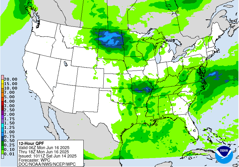
...Northern Plains into the Midwest and Mid-South...
A building upper ridge situated over the southern Rockies will tend
to result in northwest flow aloft across the northern Plains to the
ArkLaTex region. Multiple convective complexes are likely to
develop on the eastern periphery of this upper ridge, and
convective development will depend on whether a low-mid level cap
can be eroded, and this is more likely to happen across eastern
portions of Kansas/Oklahoma/Texas. The latest model guidance is
converging more on a concentrated area of enhanced rainfall across
portions of southwestern Missouri and northwestern Arkansas and
adjacent portions of Kansas and Oklahoma, where an organized MCS is
more likely to develop. Therefore, a Slight Risk area has been
introduced for this region.
Hamrick
Day 2 threat area:
www.wpc.ncep.noaa.gov/qpf/98epoints.txt
Excessive Rainfall Discussion
NWS Weather Prediction Center College Park MD
1140 AM EDT Sat Jun 14 2025
Day 3
Valid 12Z Mon Jun 16 2025 - 12Z Tue Jun 17 2025
...A MARGINAL RISK OF EXCESSIVE RAINFALL IS VALID FOR PORTIONS OF
THE UPPER MIDWEST, MID-SOUTH, AND THE MID-ATLANTIC...
...Mid-Atlantic region...
Overall, an improvement compared to what is expected over the
weekend, but there should still be enough moisture in the general
vicinity of a stalled stationary boundary over southern Virginia
and North Carolina to produce scattered storms with heavy rainfall.
Although the magnitude of rainfall expected on Monday is not
impressive, the very saturated ground by this time will be an
aggravating factor in terms of flooding potential, and therefore a
Marginal Risk area is valid from central West Virginia to the Outer
Banks of North Carolina.
...Mid-South...
The latest model guidance is honing in on a potential MCS that
could develop across portions of eastern Arkansas into western
Tennessee on Monday, and perhaps extending into portions of
southern Missouri and western Kentucky where the potential exists
for 1 to locally 2 inches of rainfall. A Marginal Risk area is
valid here since much of this rain would likely happen over a two
hour time period.
...Dakotas to the western Great Lakes...
A surface low over South Dakota with broad warm air advection ahead
of it will fuel the development of additional scattered showers and
storms on Monday. The model guidance remains varied in regards to
placement of QPF maxima, so a broad Marginal Risk is valid.
Day 3 threat area:
www.wpc.ncep.noaa.gov/qpf/99epoints.txt


