Excessive Rainfall Discussion
NWS Weather Prediction Center College Park MD
906 AM EDT Mon Jun 16 2025
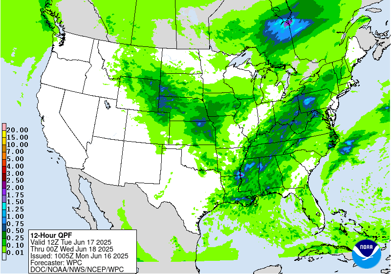
Day 1
Valid 130Z Mon Jun 16 2025 - 12Z Tue Jun 17 2025
...THERE IS A SLIGHT RISK OF EXCESSIVE RAINFALL ACROSS PORTIONS OF
THE OHIO VALLEY AND MID-ATLANTIC STATES...
13Z Update...
Expanded Marginal Risk down the rest of the TX coast.
Ongoing activity south of Corpus Christi is pivoting on itself as
an MCV at the southern extension of a mid-level trough along the
TX Coast continues to shift south. Extreme moisture with PW of 2.3"
over the Lower TX Coast should continue to allow rainfall rates to
locally exceed 2"/hr. The heaviest rain should continue to be near
the coast, so a Marginal Risk should suffice. Activity along the
middle TX coast warranted expanding the existing Marginal Risk that
ended near Houston instead of drawing a separate area.
Jackson
09Z issuance...
...Ohio Valley through the Mid-Atlantic...
Broad warm sector south of a wavering front draped from the
Central Plains through the Ohio Valley and into the Carolinas will
fuel widespread thunderstorm activity today. As this front wavers
across the region through today and tonight, shortwave impulses
embedded within broad SW flow around a Bermuda-type ridge will lift
across the area. These impulses, especially where they move atop
the residual baroclinic zone accompanying the front, will serve as
a focus for convective development leading to rounds of
thunderstorms. Although, in general, shear will be modest
suggesting primarily disorganized pulse-type thunderstorms which
are also suggested by simulated reflectivity within CAMs, there may
be two areas of focused thunderstorm development leading to a
higher potential of excessive rainfall.
The first will be in a stripe from the Bootheel of Missouri east
into southern Ohio. Here, the front will linger through today while
a potent vorticity maxima rotates overhead. The interaction of these
two may cause low-pressure development to locally enhance ascent.
Thermodynamics across this region will be impressive, characterized
by MUCAPE of 1000-2000 J/kg coincident with a plume of PWs exceeding
2 inches, more than 2 sigma above the climatological mean.
Additionally, some modestly enhanced shear approaching 35 kts will
lift northward to help organize thunderstorms, enhancing both the
intensity and longevity of heavy rainfall. With rates progged by
both the HREF and REFS likely exceeding 1"/hr (50-70% chance), and
an increasing likelihood of at least short-term training as Corfidi
vectors weaken to just 5 kts, this has the potential to produce
locally 3-5 inches of rain which has a 30-50% chance of exceeding
the 3-hr FFG.
The other locally enhanced threat for excessive rainfall will again
be along this wavering front, but farther east from SW Pennsylvania
through North Carolina. Here, a stalled backdoor front will
provide the impetus for thunderstorm development, especially during
the aftn/eve when thermodynamics are most impressive. The high-res
CAMs suggest the best threat for any organization will be across
VA/NC this evening, likely in response to a convectively enhanced
shortwave moving eastward and interacting with the front,
potentially leading to an MCS or multiple clusters of thunderstorms
moving across this area. With rainfall rates likely exceeding
2"/hr and just 5 kt Corfidi vectors aligned anti-parallel to the
mean westerly flow, training of cells is expected which results in
HREF and REFS probabilities for 3" of rain exceeding 70%. This
could produce excessive rainfall despite relatively higher FFG,
especially in NC where MRMS 24-hr rainfall has been locally as much
as 6 inches, creating more vulnerable soils. There was some
coordination tonight with WFO MHX/RAH to discuss a possible
upgrade to a MDT risk, but modest HREF/REFS ensembles and
uncertainty in placement of the afternoon convection (which could
be displaced south of ongoing activity due to convective adjustment
of the front itself) prompted a delay in any upgrade at this time.
However, an adjustment to the SLGT was made to focus the highest
risk over the HREF 3" EAS probabilities and low-percentage 100-yr
RI exceedances.
Farther upstream across VA and back as far as PA, recent heavy
rain has lowered FFG to just 1-2"/3hrs, so even less organized
thunderstorms over these more sensitive soils will promote a flash
flood risk.
Displaced to the south from these more focused excessive rainfall
risk regions, rounds of thunderstorms developing within robust
thermodynamics, especially during peak aftn/eve heating, will pose
at least an isolated flash flood risk. This will be due to rainfall
rates which have a 30-50% chance of exceeding 2"/hr, and could be
slow moving to produce locally more than 3 inches of rain. Both REFS
and HREF probabilities of exceedance are scattered across the
region, suggesting the inherited MRGL risk is sufficient, and this
was just cosmetically adjusted for new guidance.
...Dakotas to the western Great Lakes...
A messy mid-level pattern persists over the northern tier of the
CONUS as dual troughs, one over the Pacific Coast and another
lifting over the Great Lakes leaves pinched but zonal flow from the
Rockies into the Upper Midwest. However, this pattern will evolve
today as the primary trough digs into the Great Basin and sheds
lobes of vorticity eastward within the progressive flow. Any of
these impulses could become the impetus for thunderstorms,
especially this evening and tonight as a cold front digs from the
Northern Rockies into the Upper Midwest. The CAMs feature a variety
of different MCS solutions tonight as the LLJ ramps up to 30-40
kts over KS/OK, surging elevated PWs above 1.75 inches and
increasing MUCAPE northward. Where this most efficiently impinges
into the boundary, resultant convection will likely blossom through
the convergence/isentropic ascent, and where this occurs beneath a
vorticity maxima, MCS development will likely be the result.
With broad SW flow aloft helping to increasing column moisture from
MT all the way into the Great Lakes, any of these clusters of
thunderstorms which develop could produce an excessive rain risk.
However, there is limited spatial agreement among the deterministic
models as to which area will have the greatest focus. Additionally,
mean 0-6km winds of 20-30 kts suggest storms will be fast moving,
somewhat limiting the flash flood risk despite rain rates eclipsing
1"/hr. For this reason, no upgrade from the MRGL risk is warranted
with this update. However, a subtle locally higher risk may exist
across NE/KS/IA tonight where the environment appears to support at
least a subtly higher training potential due to Corfidi vectors
angled more right of the mean wind and possibly regeneration
occurring along the western tail of the front into more impressive
thermodynamics. However, exceedance probabilities remain modest, so
for now the MRGL risk remains but a targeted upgrade may be needed
with later issuances.
Weiss
Day 1 threat area:
www.wpc.ncep.noaa.gov/qpf/94epoints.txt
Excessive Rainfall Discussion
NWS Weather Prediction Center College Park MD
906 AM EDT Mon Jun 16 2025
Day 2
Valid 12Z Tue Jun 17 2025 - 12Z Wed Jun 18 2025
...THERE IS A SLIGHT RISK OF EXCESSIVE RAINFALL ACROSS PORTIONS OF
THE CENTRAL APPALACHIANS AND THE CENTRAL PLAINS/MIDWEST...
...Central Appalachians...
Broad SW mid-level flow downstream of an amplifying trough will
produce another day of active convection across the eastern CONUS.
As the SW flow amplifies, convectively charged shortwaves embedded
within the amplifying flow will surge northeast, interacting with a
residual front to produce a wave of low pressure lifting into the
Great Lakes Tuesday evening. Downstream of this low, the front is
likely to begin to lift northward as a warm front, aided by return
low-level flow around a ridge off the Southeast coast. Together,
these features will produce favorable thermodynamics and kinematics
for heavy rain producing convection.
Deep SW flow through much of the column from the Gulf Coast into
the northern Mid-Atlantic states will produce an environment
favorable to heavy rain producing thunderstorms in many areas. This
is supported by NAEFS PW anomalies that reach above +2 sigma across
most of the region, with locally enhanced PWs above the 99th
percentile of the CFSR climatology arcing from VA into Upstate NY.
With many of the available CAMs (where available temporally)
suggesting widespread convective development in this environment,
and HREF/REFS 1"/hr rainfall probabilities reaching 40-50%, at
least an isolated excessive rainfall risk exists. However, the
greatest potential appears to center from eastern OH through parts
of PA/WV/VA where the warm front will focus more consolidated or
organized convection thanks to a bubble of 35-45 kts of bulk shear,
which when combined with Corfidi vectors collapsing to 5-10 kts,
will result in a subtly enhanced repeating/training risk. This is
also where FFG is most compromised due to recent heavy rain events
(and more possible Monday) which led to the inherited SLGT risk
just being modified for recent guidance.
...Central Plains and Midwest...
Guidance has continued to trend a bit farther SW with convective
/MCS/ activity that is expected to develop this evening across the
Central Plains. Thunderstorms will likely develop across the High
Plains this afternoon and then push east in response to
accompanying shortwaves surging east within pinched but
increasingly amplified flow. While multiple impulses are progged to
eject into the Plains this evening, the amplifying shortwave across
KS is likely to become the dominant feature, and its interaction
with a surface cold front will help spawn low pressure lifting
along the boundary. Exactly where this occurs is still somewhat
uncertain as there is a lot of latitudinal spread among the
available deterministic models, suggesting an ensemble based
approach is best at this time range for such small features.
However, there has been a noted SW trend in the models, so while
exact placement is still uncertain, confidence is increasing that
the greater excessive rain risk will be more across NE/KS than IA,
which is additionally supported by the recent CSU First Guess
fields, so the SLGT risk has been adjusted accordingly.
As convection develops this aftn/eve, it will organize in response
to 30-50 kts of bulk shear, aided by 40+ kts of an 850mb LLJ that
will locally back in response to the developing low pressure. This
will focus the strongest moisture confluence into eastern KS/NE
where PWs may touch above 2 inches, leading to 850mb moisture flux
of +2 to + 2 sigma, coincident with the draw of elevated
instability surpassing 3000 J/kg. This environment will be
extremely favorable for heavy rain, and although both the 00Z HREF
and 06Z REFS forecast a high probability (>60%) for 1"/hr rates
even by 00Z Wednesday, as the convection is just beginning to
organize and intensify. As any clusters or MCS begin to dive SE
into the moisture, enhanced training is likely and this will
enhance the excessive rain risk, which was adjusted to cover the
highest probabilities for 3" and the accompanying PMM.
Weiss
Day 2 threat area:
www.wpc.ncep.noaa.gov/qpf/98epoints.txt
Excessive Rainfall Discussion
NWS Weather Prediction Center College Park MD
906 AM EDT Mon Jun 16 2025
Day 3
Valid 12Z Wed Jun 18 2025 - 12Z Thu Jun 19 2025
...THERE IS A MARGINAL RISK OF EXCESSIVE RAINFALL FROM THE MID-
MISSISSIPPI VALLEY THROUGH THE GREAT LAKES...
A potent shortwave trough will emerge from the High Plains early
Wednesday and then rotate east/northeast, reaching the Western
Great Lakes by the end of D3. This feature will remain amplified
through its lifespan, interacting with a cold front across the
Plains to drive low pressure development over Kansas late Tuesday
into Wednesday. This low will then advect progressively northeast
beneath the parent trough, helping to enhance ascent through the
area. This lift will move into favorable thermodynamics for heavy
rainfall, as PWs rise to above the 90th percentile according to
NAEFS, coincident with a ribbon of MUCAPE of 2000-3000 J/kg being
drawn northward ahead of the front and low. This will support
widespread showers and thunderstorms, with hourly rainfall
exceeding 1 inch at times as storms move along the front. Storm
motions are likely to remain progressive much of Wednesday as 0-6km
mean winds are forecast to reach 30 kts, but repeating rounds are
possible as these winds track parallel to the front. This will
support stripes of heavy rainfall for which both the GEFS and ECENS
probabilities suggest have a 5-10% of exceeding 3 inches in a few
areas, resulting in a MRGL risk for excessive rainfall.
Day 3 threat area:
www.wpc.ncep.noaa.gov/qpf/99epoints.txt
Extended Forecast Discussion
NWS Weather Prediction Center College Park MD
259 AM EDT Mon Jun 16 2025
One more day of unsettled weather is forecast broadly across the
eastern U.S. Thursday (day 4) with the approach of another upper-
level wave and leading surface frontal system. Scattered to
widespread showers and storms are expected ahead of a cold front
stretching from the Northeast southwest through the Mid-
Atlantic/Appalachians and into the Tennessee/Lower Mississippi
Valleys. Seasonably high precipitable water values will bring the
threat for some locally heavier rainfall and have maintained a
Marginal Risk ERO for isolated flash flooding along the front over
lower FFGs/terrain sensitive areas from the Interior
Northeast/northern New England southwest through the Appalachians.
Moderate instability with daytime heating ahead of the front along
with sufficient shear as the upper-wave approaches will bring the
threat of some severe storms to the central Appalachians through
Mid- Atlantic as well, with the Storm Prediction Center noting the
risk for mainly damaging winds. Storm potential will focus
southward with the front along the Gulf Coast and northward across
the Great Lakes/Northeast with the lifting upper-jet Friday into
the weekend. Embedded impulses withing the growing upper-ridge over
the central U.S. will trigger convection, potentially organized,
across the Upper Midwest/Great Lakes Friday (day 5) with a Marginal
Risk ERO in place as a strong low level jet and high precipitable
water values (2 standard deviations above the mean) support the
threat of heavy rainfall/isolated flash flooding. Additional but
uncertain influx of tropical moisture into south Texas may bring
locally heavy downpours, with a Marginal Risk for days 4/5 focused
along the Rio Grande Valley for now, but further adjustment/higher
probabilities may be needed as confidence in this scenario grows.
This influx of moisture also looks to bring precipitation chances
further northwest into western Texas and the southern high Plains
by late weekend/early next week. Upstream, the energetic approach
of a deep upper-trough/Pacific system and northern stream into the
West will bring increasing precipitation chances to the Pacific
Northwest and northern Rockies/Plains Friday through the weekend in
unsettled flow with moderate rainfall potential. Eventual lead
frontal system development over the Plains may bring a return of
thunderstorm chances to portions of the northern/central Plains and
Midwest Sunday-Monday.
Expect a gradually shifting focus for hot, above average
temperatures across the Intermountain West/Southwest mid-next week
to expand into the central Plains by Friday, the Middle/Upper
Mississippi Valley by Saturday, and the Lower Great Lakes/Ohio
Valley/Mid-Atlantic by Sunday as a strong upper- ridge begins to
build in bringing a heat wave to start the Summer. The heat will
also begin to intensify across the Lower Mississippi Valley and
Southeast as well as the upper- ridge expands eastward. Widespread
Major Heat Risk (level 3/4) is forecast, indicating an intensity of
heat that effects anyone without adequate cooling or hydration, as
heat indices climb to 95-105, 105-110+ for the Lower Mississippi
Valley and Gulf Coast/Florida. In addition, muggy overnight lows in
the mid- to upper 70s will bring little overnight relief from the
heat. Unfortunately, this heat wave looks to persist into next
week. Highs will begin to trend cooler and below average by as much
as 10-15 degrees across portions of the Northwest by Friday and
expand into the Great Basin/northern Rockies by the weekend as an
upper- trough and associated surface cold front from the northeast
Pacific begin to overspread the region.
Putnam


