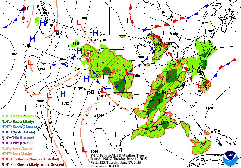
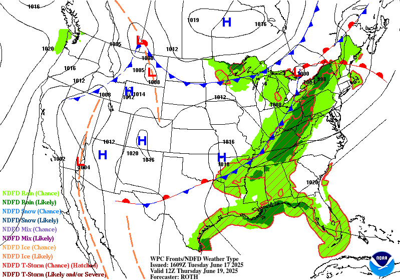
Excessive Rainfall Discussion
NWS Weather Prediction Center College Park MD
847 PM EDT Mon Jun 16 2025
Day 1
Valid 01Z Tue Jun 17 2025 - 12Z Tue Jun 17 2025
...THERE IS A SLIGHT RISK OF EXCESSIVE RAINFALL ACROSS PORTIONS OF
THE OHIO VALLEY AND MID-ATLANTIC STATES...
...Mid Atlantic...
Persistent convective pattern will remain over the region as
smaller mid-level perturbations ripple out out of the
Tennessee/Ohio Valley's helping to generate rounds of showers and
storms as they migrate eastward. Antecedent conditions across
NC up through Southwest VA, much of WV, into Western PA are
incredibly moist with generally compromised soils over portions of
Eastern NC and the Central Appalachians. The one positive this
evening is the threat of heavy rainfall becomes less pronounced in
terms of magnitude as we slowly lose the diurnal heat element that
helps drive some of the stronger convective cores. In any case, the
threat remains for pockets of heavy rain that could exacerbate
already saturated grounds, preventing recovery. QPF maxima within
latest CAMs is generally 2-3", but no real defined area of interest
with a smattering of the heavier distribution. Highest probs are
within Central NC but >5" probs drop off steadily meaning the
threat is fairly capped ~3-4" with more likely 1-2" in convection.
The previous SLGT was generally maintained.
...Ohio Valley...
Our shortwave residing over the western Ohio Valley will aid in
maintaining a general convective pattern overnight with
thunderstorms pulsing up and down through areas surrounding the
Ohio River Basin down to the KY/TN line. Locally heavy precip has
already warranted a few flash flood warnings within KY and the
threat is forecast to continue migrating to the northeast over the
course of the overnight. Some areas could see a quick 2-4" of
rainfall in any of the strongest cells with some relatively slower
storm motions help enhance the threat for training within any
multi-cell clusters. Some of the latest hourly CAMs are insistent
on a threat of storms developing between Louisville and Cincinnati
overnight with some locally heavy precip over a more urban
corridor. Considering the trend, decided to pull the SLGT a bit
more northeast to cover for the threat as any cells overnight will
be capable of 1-2"/hr rates with multiple hours of impact. The
previous SLGT risk was adjusted to reflect the radar and proposed
forecast trends in the heaviest QPF alignment.
...Midwest and Plains...
Multiple complexes will propagate through portions of the Central
Plains and Upper Midwest this evening with the greatest potential
for flash flooding likely residing over more urban centers within
the span of the MRGL risk over the region. Faster forward motions
will limit some of the threat in any given area, as well as some
areas with higher FFG's the benefactor of the expected heavy
precip. Flanking lines of complexes will be the areas of interest
within any of the organized convective schemes and pending where
they position themselves over the coverage area, a few flash flood
warnings cannot be ruled out. The previous MRGL was relatively
maintained, but trimmed back some of the northwest edge given radar
trends with no further heavy rain threat overnight.
Kleebauer
Day 1 threat area:
www.wpc.ncep.noaa.gov/qpf/94epoints.txt
Excessive Rainfall Discussion
NWS Weather Prediction Center College Park MD
447 AM EDT Tue Jun 17 2025
Day 1
Valid 12Z Tue Jun 17 2025 - 12Z Wed Jun 18 2025
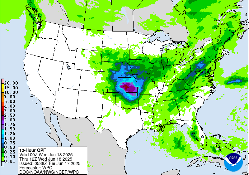
...THERE IS A MODERATE RISK OF EXCESSIVE RAINFALL ACROSS PORTIONS
OF THE CENTRAL APPALACHIANS AND THE CENTRAL PLAINS...
...Central Appalachians...
Extreme thermodynamics expanding across the eastern CONUS will
produce an environment favorable for widespread convection with
heavy rainfall on Tuesday.
The synoptic pattern responsible for this environment is set up by a
broad Bermuda-type ridge centered off the southeast Atlantic coast.
This ridge will expand northwestward, while a trough digs
concurrently across the Mississippi Valley. This evolution will
result in pinched flow between the two, accelerating the 850-500mb
flow northeast as return flow emerges more impressively from the
Gulf. Within this flow, multiple mid-level impulses/shortwaves
will lift progressively northeast, providing waves of enhanced
ascent from the Central Gulf Coast through the Mid-Atlantic states.
Additionally, the low-level flow surging northeast will reach
20-30 kts at 850mb, lifting isentropically atop a wavering front
anchored NW to SE across the Ohio Valley and Mid-Atlantic. This
will produce additionally enhanced ascent to increase convective
potential in that area.
The high-res CAMs are in good agreement in a ribbon of widespread
thunderstorms during peak aftn/eve heating from Louisiana into
Upstate NY, but organization is expected to be minimal as 0-6km bulk
shear is progged to just be around 20-25 kts, and storms should move
progressively to the northeast on 20-30 kts of mean wind. However,
any storm will likely contain impressive rain rates as PWs, which
are currently analyzed via the CIPS LPW percentiles to be above the
90th percentile from sfc-500mb, may approach 2 inches as far north
as PA and NY, which would be daily records at both OKX and PIT if
reached. This near-record PW and deep warm cloud depths of 13000-
14000 ft will support hourly rainfall that has a chance (20-40%) of
exceeding 2"/hr, with sub-hourly rain rates of 3-4"/hr possible.
Despite a lack of organization, repeating rounds of thunderstorms
with these intense rain rates could produce stripes of rainfall
exceeding 3" (50-60%) and locally 5" (20-30%) with the greatest
potential for the higher accumulations are suggested by both HREF
and REFS guidance occurring over PA invof the front.
With FFG extremely compromised in parts of the Mid-Atlantic, this
has prompted an upgrade to a MDT risk for excessive rainfall.
Elsewhere, a SLGT risk continues for portions of the Central
Appalachians, with a MRGL risk extending all the way to the Gulf
Coast where heavy rain is also expected, but in a less organized
fashion and atop drier antecedent soils with more filtration
capacity.
...Central Plains...
Generally flattened/zonal flow across the western CONUS will
amplify today as a potent shortwave dives out of the Rockies and
amplifies sharply into the Plains this evening. Impressive ascent
downstream of this shortwave will impinge into a cold front draped
across the Plains, resulting in surface low pressure development
this evening as well. This will enhance ascent locally, especially
as the LLJ ramps up to 40-50 kts, and is locally additionally
enhanced downstream of the developing low pressure, especially in
KS/OK. This LLJ will draw impressive thermodynamics northward
reflected by PWs rising above 1.75 inches collocated with MUCAPE
potentially exceeding 4000 J/kg. Where this LLJ converges both
along its nose and into the wavering surface front, convection is
expected to develop this evening, and then grow upscale and
intensify tonight.
In the presence of these impressive thermodynamics, both REFS and
HREF hourly rainfall probabilities have increased to above 40% for
2"/hr rates, and it is likely maximum sub-hourly rainfall rates will
be at least double that. This is in response to increasing shear and
the upscale growth of thunderstorms into clusters or an MCS, to
provide locally enhanced lift through convergence/mergers. The high-
res CAMs are in generally good agreement in this evolution after 00Z
tonight, although some latitudinal spread continues, likely in
response to an MCS presently moving across NE/KS, which will
somewhat impact the evolution 24-hrs from now in response to
residual boundary placement. The greatest potential for the heaviest
rainfall tonight is forecast to be across eastern KS and into
northeast OK where both the REFS and HREF probabilities indicate a
40-70% and 20-40% chance of 3" and 5", respectively. This will occur
atop pre-conditioned soils from antecedent rainfall, leading to FFG
exceedance probabilities above 50%. Despite some uncertainty in
timing and placement, the excessive rainfall risk has been upgraded
to MDT for portions of KS after coordination with the affected
WFOs.
Weiss
Day 1 threat area:
www.wpc.ncep.noaa.gov/qpf/94epoints.txt
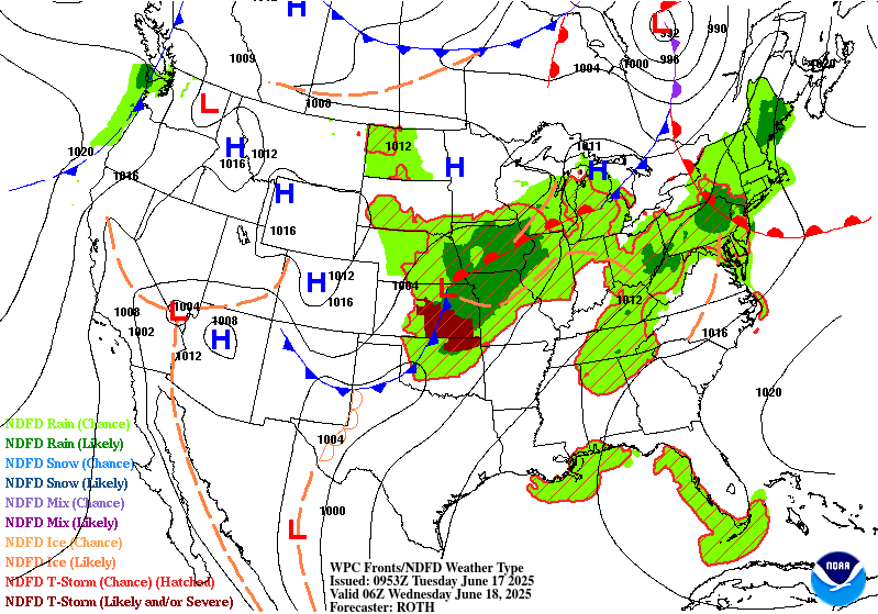
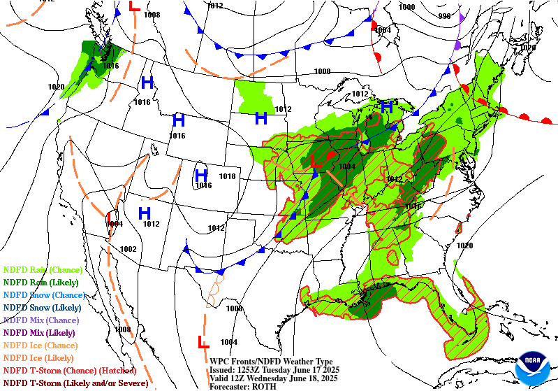
Excessive Rainfall Discussion
NWS Weather Prediction Center College Park MD
447 AM EDT Tue Jun 17 2025
Day 2
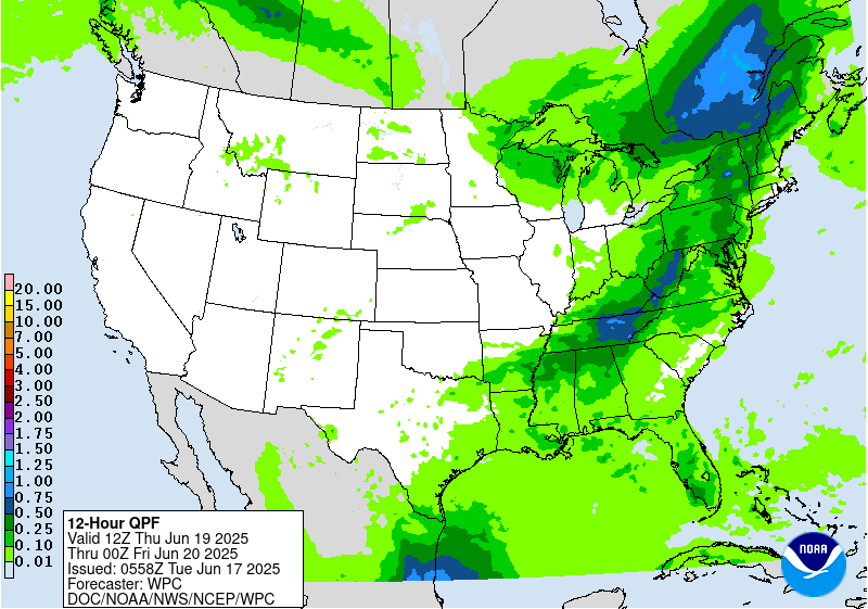
Valid 12Z Wed Jun 18 2025 - 12Z Thu Jun 19 2025
...THERE IS A MARGINAL RISK OF EXCESSIVE RAINFALL FROM THE MID-
SOUTH THROUGH THE GREAT LAKES, AND FOR PORTIONS OF THE COASTAL
MID-ATLANTIC STATES...
...Central States/Midwest...
A shortwave lifting northeast embedded within a larger trough axis
centered over the Mississippi Valley will combine with the RRQ of a
departing upper jet streak to deepen a surface low pressure
emerging out of Missouri early Wednesday. This low will track
steadily northeast, reaching Michigan Wednesday evening and then
departing into Ontario by Thursday morning. This low will move
along a baroclinic zone to the northeast, dragging its accompanying
cold front to the east and into the Midwest by the end of D2,
leading to enhanced convergence/ascent across that region as well.
The associated lift will surge into an environment which will
support scattered to widespread convection with heavy rainfall.
Intensifying 850mb inflow from the Gulf will draw higher PWs
(nearing 2") and instability (MUCAPE above 2000 J/kg) northward to
support heavy rainfall. There may be two areas of heaviest rainfall
across this region on Wednesday, one in a strengthening deformation
axis NW of the surface low track, and a second in a corridor of
convection which develops along the front.
Within the deformation, the 850mb winds will lift a theta-e ridge
northward and cyclonically around the low pressure, producing an
axis of moderate to heavy rainfall which will pivot northeast.
Instability within this deformation will be modest, and elevated
within a modest TROWAL, so rain rates will be somewhat restricted
as reflected by 1"/hr rain rate probabilities from the HREF
(through 00Z Thursday) that peak around 20-40%. However, rainfall
will be persistent as cells track along the axis, leading to a
prolonged period of moderate rain with embedded higher rain rates.
This will produce an axis with GEFS, ECENS, and SREF probabilities
indicating a 5-15% chance for 3" of rain, which may result in
localized excessive rainfall impacts.
Farther south along the front, instability is much more robust and
this is reflected by rainfall rate probabilities that reach 60% for
1"/hr and 20-30% for 2"/hr. However, coverage of precipitation will
be more scattered as thunderstorms develop along the front and
organize into clusters moving rapidly to the northeast along the
front itself. This could result in some training/repeating, but the
progressive nature of individual cells should limit the overall
flash flood risk. Rainfall across this region could again exceed 3"
in a few areas as noted by similarly low probabilities of 3"/24hrs,
but the more intense rates still support a MRGL risk of excessive
rainfall.
...Coastal Mid-Atlantic...
Continued return flow around a Bermuda-type ridge off the Southeast
coast will maintain broad southwesterly flow to pump elevated PWs
northward into the Mid-Atlantic on Wednesday. PWs above 1.75 inches
(above the 97th percentile according to NAEFS) will remain over the
region, as a weak surface trough swings eastward, moving offshore
Wednesday night. This weak convergent axis moving through the area
concurrent with an embedded mid-level vorticity maxima into these
robust thermodynamics will result in thunderstorms with rain
rates of 1-2"/hr. Despite the relatively isolated to scattered
nature of convection expected, any of these torrential rain rates
atop the more urban areas could cause isolated instances of flash
flooding, and the MRGL risk was adjusted accordingly.
Weiss
Day 2 threat area:
www.wpc.ncep.noaa.gov/qpf/98epoints.txt
Excessive Rainfall Discussion
NWS Weather Prediction Center College Park MD
447 AM EDT Tue Jun 17 2025
Day 3
Valid 12Z Thu Jun 19 2025 - 12Z Fri Jun 20 2025
...THERE IS A MARGINAL RISK OF EXCESSIVE RAINFALL FROM THE SOUTHERN
APPALACHIANS THROUGH NEW ENGLAND...
A mid-level longwave trough axis will progress eastward from the
Mississippi Valley to the Atlantic coast on Thursday. This trough
will push an accompanying surface cold front beneath it, and this
front is progged to move off the coast by 12Z Friday /end of D3/.
The overlap of the front with its parent trough will drive a narrow
but strong corridor of lift through height falls/convergence, into
an environment supportive of convection with heavy rain. Despite
the rapid progression of this front, a MRGL risk for excessive
rainfall exists due to potential short-duration training of
thunderstorms due to mean 0-6km winds that are parallel to the
boundary. With rain rates likely eclipsing 1"/hr at times, this
should produce stripes of 1-2" of rainfall, with locally as much as
3" in a few locations as suggested by GEFS and SREF 3"/24hr
probabilities. While in general this suggests only an isolated
flash flood risk, and the updated MRGL risk, should any heavier
rain fall atop the more vulnerable soils of the central
Appalachians, a targeted SLGT could be needed in future updates.
Weiss
Day 3 threat area:
www.wpc.ncep.noaa.gov/qpf/99epoints.txt
Extended Forecast Discussion
NWS Weather Prediction Center College Park MD
258 AM EDT Tue Jun 17 2025
Late week/weekend will bring a pattern change as an amplifying
upper-level ridge over the central/eastern U.S. shifts the storm
track northward and brings a period of drier conditions to many
after unsettled weather much of the week. Embedded impulses within
the upper-ridge will trigger convection, potentially organized,
across the Upper Midwest/Great Lakes Friday (day 4) and Great
Lakes/Interior Northeast Saturday (day 5). A Marginal Risk ERO is
in place for both days as a strong low level jet and high
precipitable water values (up to 2 standard deviations above the
mean) support the threat of heavy rainfall and at least isolated
flash flooding. An embedded Slight Risk looks possible based on
forecast QPF values with more confidence in areal placement of this
organized convection. Daily showers and thunderstorms are also
expected in vicinity of the Gulf Coast as a frontal boundary
lingers in the region and with possible influence of tropical
moisture for the western Gulf Coast/south Texas. This influx of
moisture also looks to bring precipitation chances further
northwest into western Texas and the southern high Plains by late
weekend/early next week. Upstream, the energetic approach of a deep
upper- trough/Pacific system and northern stream into the West
will bring increasing precipitation chances to the Pacific
Northwest and northern Rockies/Plains Friday through the weekend in
unsettled flow with moderate to heavy rainfall potential. A
Marginal Risk ERO has been added for Friday (day 4) for portions of
north-central Montana given the presence of strong, very moist
upslope flow to support heavy rainfall. Eventual lead frontal
system development over the Plains will bring a return of
thunderstorm chances to portions of the northern/central Plains and
Midwest Sunday and particularly Monday- Tuesday, with potential
for more heavy rainfall/flash flooding as well as severe weather.
The first significant heat wave of the season is expected across
the central Plains by Friday, the Middle/Upper Mississippi Valley
by Saturday, and the Lower Great Lakes/Ohio Valley/Mid-Atlantic by
Sunday thanks to anomalous upper-level ridging building overhead.
Summer heat will also begin to intensify across the Lower
Mississippi Valley and Southeast as the ridge expands eastward.
Widespread Major to Extreme Heat Risk (levels 3 and 4/4) is
forecast, indicating an intensity of heat that is dangerous to
anyone without adequate cooling or hydration, as heat indices climb
into the 100-110 degree range, potentially higher. In addition,
muggy overnight lows in the mid- to upper 70s will bring little
overnight relief from the heat. Unfortunately, this heat wave looks
to persist through at least the middle of next week. Highs will
begin to trend cooler and below average by as much as 10-20 degrees
across portions of the Pacific Northwest by Friday and expand into
the Great Basin and northern Rockies/High Plains by the weekend as
an upper level trough and associated surface cold front from the
northeast Pacific begin to overspread the region.
Putnam


