Excessive Rainfall Discussion
NWS Weather Prediction Center College Park MD
1159 AM EDT Tue Jun 24 2025
Day 1
Valid 16Z Tue Jun 24 2025 - 12Z Wed Jun 25 2025
...THERE IS A MODERATE RISK OF EXCESSIVE RAINFALL OVER PORTIONS OF
CENTRAL AND SOUTHERN NEW MEXICO...
...16Z Update...
Subtle changes overall compared to the overnight forecast. Numerous
instances of flash flooding -- some of which will be significant --
are expected over Central/Southern New Mexico and far West Texas
today. The main adjustments included a southward extension of the
Moderate Risk area to encompass El Paso based upon 12z sounding
data featuring PWATs around the daily max value, and 24 HR HREF
neighborhood probabilities of 2-3" around 40-60%.
Asherman
...New Mexico...
A massive 597dm ridge centered over the Ohio Valley and Mid
Atlantic will flex further as we head into Tuesday with the higher
heights on the western fringes pushing back west beyond the eastern
portions NM. A steady north- south progression within the mid and
upper levels will send numerous smaller shortwave perturbations
poleward with anticipated motions into the Sacramento's, eventually
north into the Sangre de Cristos by the late-afternoon and evening
period today. Anomalous moisture ranking in the 99th percentile
via NAEFS and ECENS Climatological percentiles will remain parked
over the region the next 24-36 hrs and will couple with the focused
ascent and narrow upslope proxy within the Sacramento Mtns. This
will translate to a corridor of heavy convection remaining situated
in- of the terrain beginning late this morning and carrying
through peak diurnal instability. Consensus within all
deterministic and relevant ensembles agree that local topographic
effects within this pattern will yield some significant rainfall
potential over areas that are prone to flash flooding, especially
with the burn scars still present near Ruidoso creating higher
runoff capabilities. 00z HREF neighborhood probabilities were
elevated for the >3" (60-80%) and >5" (30-60%) prospects within the
Sacramento's for the period. The biggest difference is the
increased probs for those similar thresholds for areas west of the
Sacramento's, encroaching on places northeast of the Bootheel into
Southern NM.
The difference the past 24 hrs. has been the expected influence of
the approaching trough out west providing a reinforcement of the
trailing upper jet with the amplitude of the pattern creating more
room further west for large scale ascent, and moisture advection
back into the western half of NM, even sneaking into Southeast AZ.
The entire evolution will likely spur scattered to widespread
thunderstorm activity over the aforementioned regions with cold
pool mergers from storms likely to produce some upscale growth in
the evening as the convergence of cold pools will act to spawn more
multi-cell modes. A lot of the deterministic now has locally 2-4"
across places like the San Mateo Mtns. and adjacent deserts
stemming from the convective clusters propagating eastward over the
second half of the forecast cycle. These areas are prone to any
type of heavy rainfall, and given the highly anomalous environment,
1-2"/hr rates are certainly in the cards. This threat will linger
through the overnight time frame before finally settling closer to
Wednesday AM.
Further north, the signal for heavy rainfall continues into the
Sangre de Cristos where the afternoon and evening time frames call
for widespread heavy thunderstorm activity aligned with the ridges
of the southern Rockies. These areas also have burn scar prevalence
that could exacerbate flash flood risks as runoff capabilities are
maximized. 24hr 100yr ARI exceedance probabilities are highest
across Central and Southern NM, but a small axis of >20% probs
remains parked over the Sangre de Cristos north of Santa Fe. 10yr
ARI exceedance probs are between 60-80% for the same area (90+%
over the Sacramento's), so the threat is within the upper echelon
of the prob fields leading to a higher chance of significant
impacts over the complex terrain and remnant burn scars.
The previous MDT risk was expanded westward to include those areas
that could see locally as much as 2-4" in any storm impacts this
afternoon and evening lasting into early Wednesday. A high-end MDT
is forecast for the Sacramento and Sangre de Cristo Mtns. in NM.
High end SLGT risk is forecast for El Paso proper and surrounding
suburbs. There's a chance the threat for El Paso trends more
impactful, so be sure to check in with the latest updates in the
next forecast package for a potential upgrade over the urban
center.
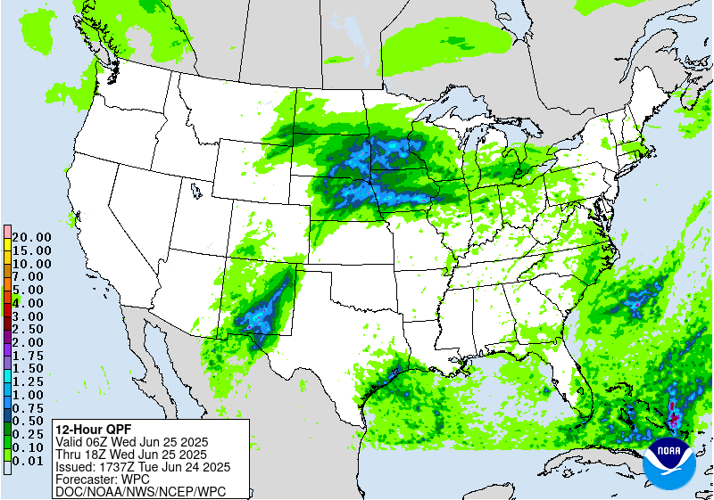
...Central Plains to Midwest...
Current radar/sat composite shows an extensive line of convection
extending from southwest to northeast out of KS to as far north as
Central WI. The setup for the convective pattern lies within the
northern periphery of a ridge and along a quasi-stationary front
bisecting the areas above. Smaller shortwaves rounding the western
flank of the ridge will continue riding over top the front
creating focused areas of showers and thunderstorms through the
first 6hrs of the period with some areas over far Northeast KS into
Northwest MO and Southern IA seeing a continuation of locally
heavy rainfall bleeding into the new D1. This area is the focus
initially for flash flood impacts with saturated grounds likely to
struggle to withstand the initial batch of storms that push
through. Thankfully, there will be a small "break" in the
persistence of the convective pattern moving into the late-morning
and afternoon, but still some scattered shower/storm development
will be forecast during the prime destabilization period, so the
threat for isolated flash flooding will carry through the daytime.
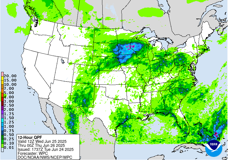
By the evening, the focus of the convective pattern shifts back
west and southwest with an ejection of a potent shortwave out of
the Southern High Plains and Front Range of the Rockies. With ample
instability presence across the Central Plains into the Midwest
along the quasi-stationary front, a second convective onslaught is
forecast to materialize likely beginning between 20-00z, carrying
east and northeast through the remainder of the forecast. At the
same juncture, a strong 700-900 kg/ms IVT pulse will be advecting
northeastward into the Central Plains and Midwest during the time
frame of interest (00-12z Wednesday), so the heavy rain threat with
2-3"/hr rates will certainly have potential for basically anywhere
in the Central Plains/Midwest domain. There's a growing consensus
on the area positioned over Southern SD, much of NE, and parts of
KS being the initial beneficiary of the convective development
which could lead to scattered flash flood prospects within a 6hr
window upon initiation. As we move into the evening, nocturnal LLJ
will spawn in-of the High Plains arcing northeast into parts of the
Midwest allowing the stationary front to begin lifting north in
the form of a warm front. The mean layer flow will begin to orient
more parallel to the front itself creating an environment capable
for cells to mature and begin training over areas within proxy to
the boundary. Guidance has been subject to bouncing around on
exactly where this may occur, but 00z CAMs have come into a
reasonable agreement on an axis extending over Eastern NE,
including the Omaha metro, through Western IA. This is correlated
with the higher neighborhood probs for >2" (50-70%) aligned over
the area with the >3" signal pretty respectable (40-60%) over the
same area. The highest probs and overlap of heavy precip within the
CAMs is surprisingly directly over Omaha and surrounding areas.
This depicting likely stems from the nose of the LLJ being forecast
to right over the general vicinity, a synoptic representation that
typically denotes a greater likelihood of where the heavier precip
could occur. It will be something to monitor in the next
succession of CAMs output, but with such a solid signal, was
inclined to mention as a higher end SLGT will be forecast within
that Eastern NE through Western IA region.
Further north, a complex of storms will originate over Southern SD
from another shortwave progression moving through the Northern
Plains. This area could see the benefit of cell mergers somewhere
in the proxy of Southeast SD into Southwest MN as depicted within
multiple deterministic. Considering this area levying higher FFG's
compared to areas further south, the threat for significant flash
flooding is lower, but still generally within the SLGT risk
threshold considering the airmass in place. The SLGT risk is
positioned as far back as Northeast CO into Southern NE and as far
east as Northern IL and Southern WI thanks to multiple periods of
heavy convection impacting the region.
Kleebauer
Day 1 threat area:
www.wpc.ncep.noaa.gov/qpf/94epoints.txt
Excessive Rainfall Discussion
NWS Weather Prediction Center College Park MD
1159 AM EDT Tue Jun 24 2025
Day 2
Valid 12Z Wed Jun 25 2025 - 12Z Thu Jun 26 2025
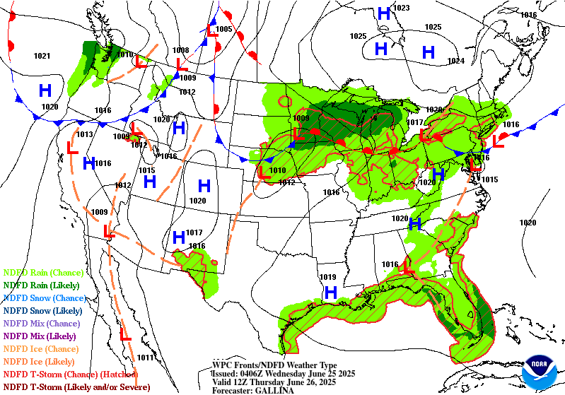
...THERE IS A SLIGHT RISK OF EXCESSIVE RAINFALL OVER PORTIONS OF
NEW MEXICO, CENTRAL PLAINS AND MIDWEST...
...New Mexico...
Despite a smaller areal coverage anticipated for convection across
New Mexico for Wednesday, scattered thunderstorms will still
cause problems during afternoon initiation as ample heating during
the prime destabilization window (16-21z) will yield another
threat of heavy rainfall across the terrain and adjacent valleys in
Central and Southern NM. Current signals are nowhere near as
robust as the D1 time frame, but with forecasted significant
impacts the period prior, there's a greater threat of truly
compromised FFG's leading in, allowing for the bar to be very low
for flash flooding over areas that will see significant rainfall in
the areas referenced above. Hi-res ensemble blended mean QPF is now
solidly within the 1-2" range with locally higher totals across the
Sacramento's. Areal average 0.5-1" of rainfall is forecast over
much of South-Central NM and over the Sangre de Cristos with totals
potentially up to 2" in stronger convective cores. The overlap with
the previous period allows for at least a SLGT risk with a higher
end SLGT progged over the Sacramento's where convective initiation
is likely. A targeted upgrade is plausible within the two main
mountain areas in the state, especially when you factor in the
antecedent conditions for the period in question. If CAMs come in
more robust, or impacts during the D1 are severe enough to fully
compromise soils to where any convective threat could be deemed
significant.
...Central Plains to Midwest...
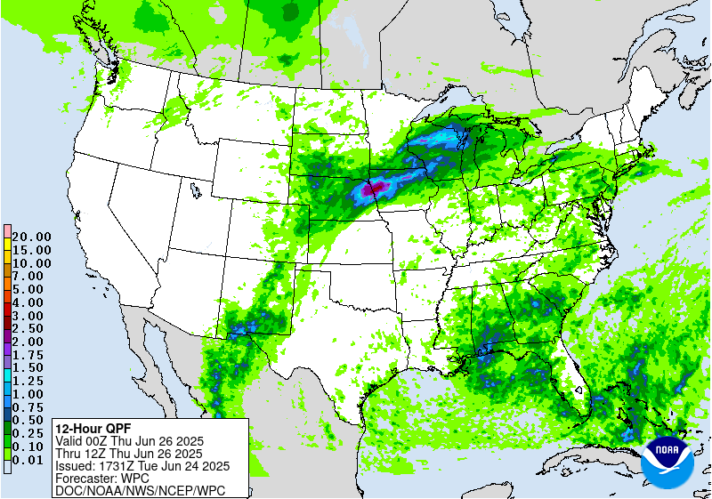
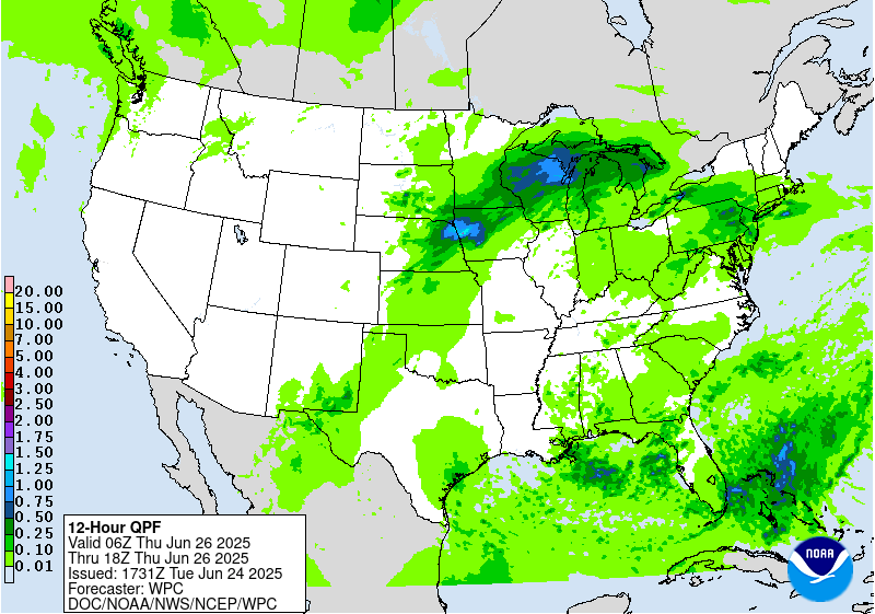
Convective pattern across the Plains and Midwest at the end of the
D1 will translate northward into the Upper Mississippi Valley with
organized convection over NE/IA and SD/MN converging along the
propagating warm front leading to a swath of heavy rainfall across
much of the Southern 1/3rd of MN. All guidance is in agreement on a
pretty significant QPF shield moving through the area encompassing
Southern MN up through Northwest WI with some back-building
potential along the front as it migrates north and begins to slow
its momentum. Areal average of 1-2" with locally up to 4" totals
are forecast across that portion of the Upper Midwest, reflected
well within the NBM 90th percentile QPF signature, as well as
within the 12-00z time frame covered by the end of the 00z HREF
blended mean. This is just round 1 of what will be yet another
secondary convective initiation come Wednesday evening when another
strong shortwave and attendant IVT pulse comes pushing back over
Eastern NE, Western IA and points north. Additional heavy rainfall
will intersect many areas that will have seen significant totals
earlier in the period and the second half of the D1. The
compounding impacts will lead to scattered to widespread flash
flood instances as FFG's will be notably lower comparatively to
the before the previous rounds. Ensemble bias corrected mean is now
between 3-4" over a large area encompassing Southern MN into
Northwest WI with 2-3" positioned just to the southwest of MN. EC
AIFS output is in agreement with the positioning of the QPF maxima
anticipated, something that has not been the case over the past few
days, so we seem to be moving into a greater consensus. As a
result, there is a large high-end SLGT risk positioned from
Northeast NE up through MN into the western portion of WI. An
upgrade within anywhere in that zone is plausible in the coming
updates as multi-day impacts could spur some locally significant
flash flood prospects.
Kleebauer
Day 2 threat area:
www.wpc.ncep.noaa.gov/qpf/98epoints.txt
Excessive Rainfall Discussion
NWS Weather Prediction Center College Park MD
1159 AM EDT Tue Jun 24 2025
Day 3
Valid 12Z Thu Jun 26 2025 - 12Z Fri Jun 27 2025
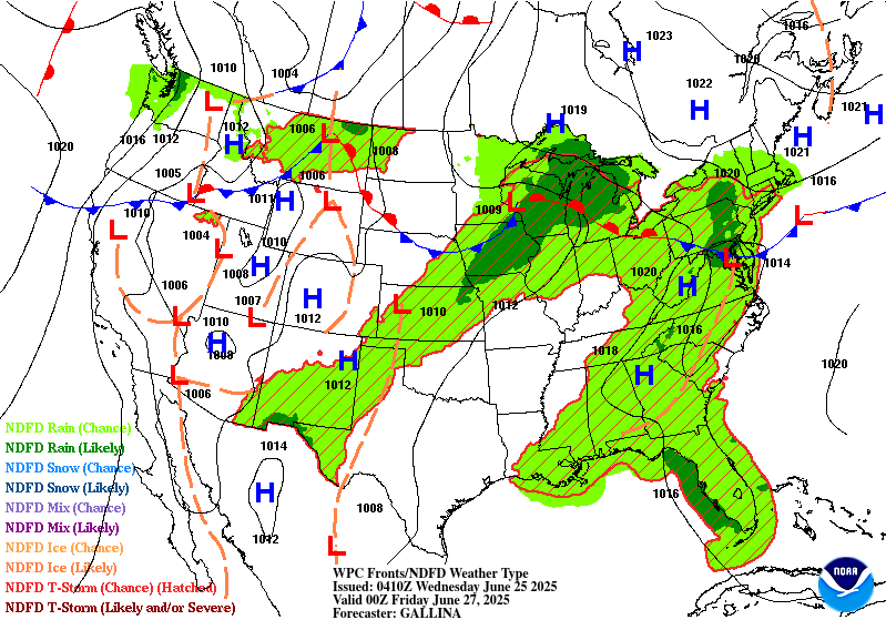
...THERE IS A SLIGHT RISK OF EXCESSIVE RAINFALL OVER PORTIONS OF
THE MIDWEST AND NORTHERN GREAT LAKES...
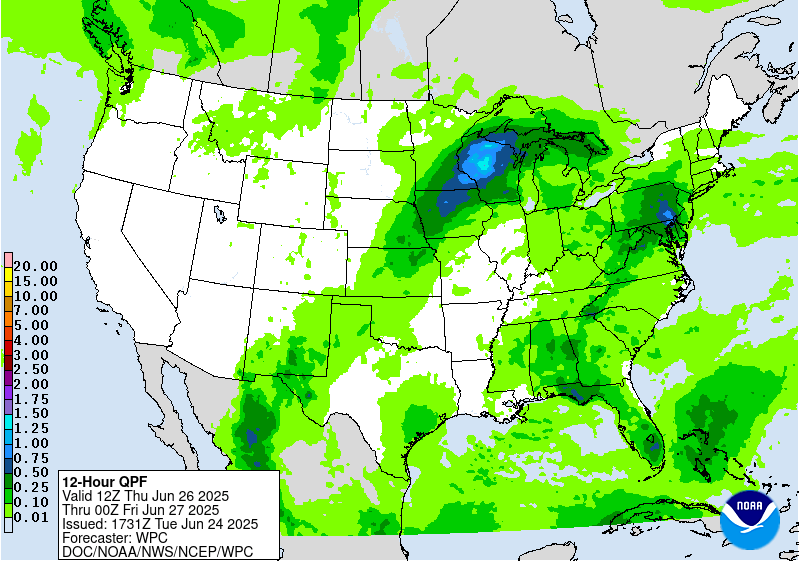
...Midwest...
The final shortwave in the progression bleeding over from the
previous D2 time frame will continue pushing northeast before
finally vacating the Upper Midwest later on Thursday. Heavy rain
threat will continue over parts of MN and WI before eventually
impacting the Western U.P. of Michigan before its departure.
Instability across the region will be significantly lower than
previous days with the warm front becoming stationary prior to
reaching the southern shores of Lake Superior. The threat for flash
flooding is most notably in the first 6-12 hr window of the
forecast with a sharp decline in the threat afterwards as the
pattern shifts with the ridge expected to be breaking down. 1-2"
with locally higher amounts will allow for flash flooding in any
area from IA up through MN/WI, especially in places where
significant rainfall has occurred in prior periods. A broad SLGT
risk remains in place over the Northern Great Lakes and Upper
Midwest with the biggest change being the extension down through
Central IA as trailing thunderstorms are forecast within the
frontal orientation Thursday afternoon and evening.
...New Mexico...
Isolated to scattered thunderstorms across the Sacramento's and
adjacent desert will maintain at least some threat for flash
flooding given expected wet antecedent conditions following
previous multi-day convective impact. Coverage and magnitude will
be lower than previous periods, but still enough of a threat and
coverage to warrant a MRGL continuation.
...Mid Atlantic...
Disturbance rounding the northern periphery of our massive ridge
will ultimately slide down through the Mid Atlantic during the
mid to late-afternoon hrs. on Thursday. The combination of strong
diurnal destabilization during the daytime and prominent moisture
lingering over the area will create a very buoyant environment
capable of strong thunderstorm genesis anywhere from NY state down
through the Central Mid Atlantic including; MD/PA/DE/Northern WV
and VA. Current projection of QPF is fairly isolated in the heavier
convective outputs with some deterministic depicting totals as
high as 2-3" in spots. Initial assessment of the setup leads
towards a low end MRGL risk for now, but will assess how models
handle the shortwave disturbance and proposed ascent pattern within
a fairly unstable environment over the next few days.
Kleebauer
Day 3 threat area:
www.wpc.ncep.noaa.gov/qpf/99epoints.txt


