Excessive Rainfall Discussion
NWS Weather Prediction Center College Park MD
855 PM EDT Tue Jun 17 2025
Day 1
Valid 01Z Wed Jun 18 2025 - 12Z Wed Jun 18 2025
...THERE IS A MODERATE RISK OF EXCESSIVE RAINFALL FOR PORTIONS OF
THE CENTRAL APPALACHIANS AND THE SOUTH-CENTRAL GREAT PLAINS...
01Z Excessive Rainfall Discussion...
Greatest threat for excessive rainfall overnight continues to be
focused mainly over southeast Kansas and a small part of adjoining
states. Too early to trim more than a small part of the western
and northern periphery given on-going convection although warming
cloud top temperatures suggest model guidance is on-track for
diminishing flash flooding threat to the north and west of on-going
Moderate Risk area.
Farther west...maintained the Moderate Risk area in the Central
Appalachians given on-going convection and satellite imagery still
showing convection located upstream. The WoFS runs continue to
favor the area along and north of the Mason Dixon Line into the
late evening/early morning hours while convection elsewhere in the
eastern US fades by 04Z or so,
Bann
...Central Appalachians to the Central Gulf Coast...
Extreme thermodynamics expanding across the eastern CONUS will
produce an environment favorable for widespread convection with
heavy rainfall today and tonight.
A broad Bermuda-type ridge centered off the southeast Atlantic
coast will expand northwestward, while a shortwave trough persists
over the Mississippi/Ohio Valleys. This will accelerate the SWly
850-500mb flow which contains multiple mid-level impulses that
provide waves of enhanced ascent from the Central Gulf Coast
through the Mid-Atlantic states.
12Z CAMs remain in good agreement on diurnal expansion of
thunderstorms in a swath from Louisiana into Upstate NY, though
poorly organized with bulk shear 20-25 kts and progressive to the
northeast on 20-30 kts of mean layer wind. However, any storm will
likely contain impressive rain rates in deep Gulf-sourced moisture
with PWs up around 2" through this swath. Daily record high PW is
possible at both OKX and PIT. This high PW and deep warm cloud
depths of 13000-14000 ft will support high hourly rainfall,
particularly around south-central PA that remains a favored area
for QPF max today where a warm front is lifting.
12Z HREF neighborhood probs have 20-30% risk of of exceeding
2"/hr in south-central PA where a Moderate Risk persists. Sub-
hourly rain rates of 3-4"/hr are possible in this environment.
FFG is extremely compromised in parts of the central Appalachians
with a Slight Risk remaining for eastern KY into northern PA. The
Marginal Risk still extending all the way to the central Gulf
Coast where isolated flash flooding is ongoing.
...South-Central Plains into the Midwest...
16Z Update...
Shrank north side of Slight Risk to focus on organized convective
activity over KS (where a Moderate Risk persists) with expansion
downstream in OK and western MO.
A potent shortwave shifts across the central Rockies this
afternoon and amplifies sharply over the Plains this evening. This
should enable vigorous terrain induced convection off the Front
Range into WY with some organization as it shift east this evening.
This will be after the ongoing activity centered on KS which is
after a powerful MCS blew through last night. Impressive ascent
downstream of this shortwave will impinge into a cold front draped
across the Plains, resulting in surface low pressure development
this evening as well. This will enhance ascent locally, especially
as the LLJ ramps up to 40-50 kts, and is locally additionally
enhanced downstream of the developing low pressure, especially in
KS/OK. This LLJ will draw impressive thermodynamics northward
reflected by PWs rising above 1.75 inches collocated with MUCAPE
potentially exceeding 4000 J/kg. Where this LLJ converges both
along its nose and into the wavering surface front, convection is
expected to develop this evening, and then grow upscale and
intensify tonight. The 12Z CAM consensus is for southern KS to be
the MCS focus this evening with repeating heavy rain where earlier
activity fell, raising the threat level.
Weiss/Jackson
Day 1 threat area:
www.wpc.ncep.noaa.gov/qpf/94epoints.txt
Excessive Rainfall Discussion
NWS Weather Prediction Center College Park MD
408 AM EDT Wed Jun 18 2025
Day 1
Valid 12Z Wed Jun 18 2025 - 12Z Thu Jun 19 2025
...THERE IS A SLIGHT RISK OF EXCESSIVE RAINFALL FOR PORTIONS OF THE
GREAT LAKES AND THE MID-SOUTH STATES...
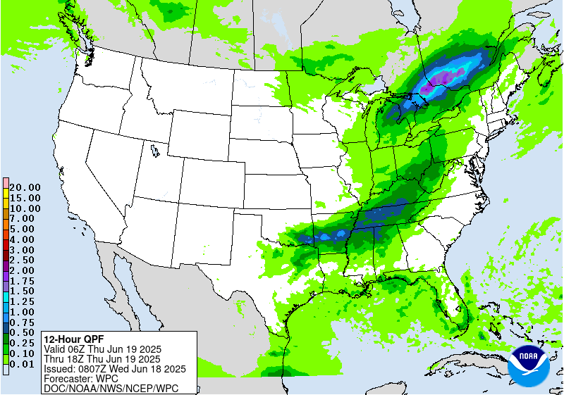
...Great Lakes through the Mid-Mississippi Valley...
Strung out shortwave embedded within amplifying mid-level flow
will swing northeast today as the primary trough axis shifts from
the Central Plains to the Ohio Valley. The collocated height
falls/PVA accompanying this energy will interact with the modest
RRQ of a departing upper jet streak to help deepen a surface low
advecting northeast into the Great Lakes. This low will strengthen
along a cold front, leading scattered to widespread showers and
thunderstorms, but with two more focused regions of excessive
rainfall.
The greatest risk for heavy rain capable of producing flash flooding
appears to be centered across the lower peninsula (L.P.) of
Michigan. Here the surface low will track, with heavy rain along a
warm front occurring ahead of the low, and secondary moderate rain
with embedded convection occurring along a deformation axis in the
same region. 850mb flow ahead of the low will surge to 20-30kts,
drawing PWs as high as 1.75 inches into MI, coincident with MUCAPE
nearing 1000 J/kg. This will support rainfall rates that have a
moderate chance (40-60%) of exceeding 1"/hr at times. The heaviest
rain rates are expected along the leading warm front thanks to
stronger instability this evening, and during that time the
combination of 20-30 kts of bulk shear and 0-6km mean winds aligned
to the front, despite progressive speeds near 30 kts, will support
rainfall that will likely (70% chance) reach 3", and may reach as
much as 5" in a few isolated locations. This could result in
instances of flash flooding (15-25% chance of 3-hr FFG exceedance)
despite generally dry antecedent conditions, and the SLGT risk was
maintained with modest cosmetic adjustments.
Farther to the south, the cold front will be the primary mechanism
for ascent/convective development as it tracks east from the Central
Plains to the Tennessee Valley. This front will impinge upon intense
thermodynamics characterized by MUCAPE above 3000 J/kg and PWs
approaching 2 inches. Thunderstorms will likely develop along the
length of this front during peak instability, and where bulk shear
exceeds 25 kts, generally from IN through AR, clusters of more
organized convection are expected. While cells will generally move
rapidly along the front, Corfidi vectors progged to collapse to
just 5-10 kts suggests some backbuilding/short term training, which
could enhance rainfall to more than 3 inches in some areas. There
is considerable latitudinal spread in the axis of highest rainfall
potential between the HREF and REFS members, leading to lower
confidence in placement of heaviest rain. However, the EAS
probabilities from both ensemble clusters, while varying greatly in
magnitude, are focused generally in the same area, and atop a
region of more sensitive soils and lower FFG due to 7-day rainfall
more than 300% of normal. A SLGT risk was added to this area to
better message the potential for this heavy rain falling atop
vulnerable soil conditions.
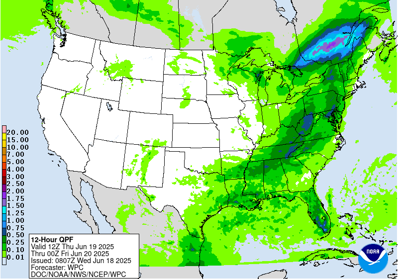
...Mid-Atlantic into New England...
Southwest return flow around a Bermuda-type ridge off the
Southeast coast will continue today, pumping elevated moisture
northward into the Mid-Atlantic States. PWs are forecast to reach
around 2 inches, which, if achieved, would exceed the daily record
at IAD and the surrounding region. This PW will be spread through
the entire column as reflected by long-skinny CAPE profiles among
the regional soundings, indicating efficient rainfall processes
within thunderstorms that develop along a weak surface trough
skirting across the area. Both the HREF and REFS probabilities
indicate a moderate potential (30-50%) for 1"/hr rates, which
despite generally progressive motion could cause axes of 2-3" of
rain where multiple rounds occur. If any of this heavy rain falls
atop urban areas or more sensitive soils from recent rain (where
FFG is as low as 1-1.5"/3hrs), isolated instances of flash flooding
could result.
Weiss
Day 1 threat area:
www.wpc.ncep.noaa.gov/qpf/94epoints.txt
Excessive Rainfall Discussion
NWS Weather Prediction Center College Park MD
408 AM EDT Wed Jun 18 2025
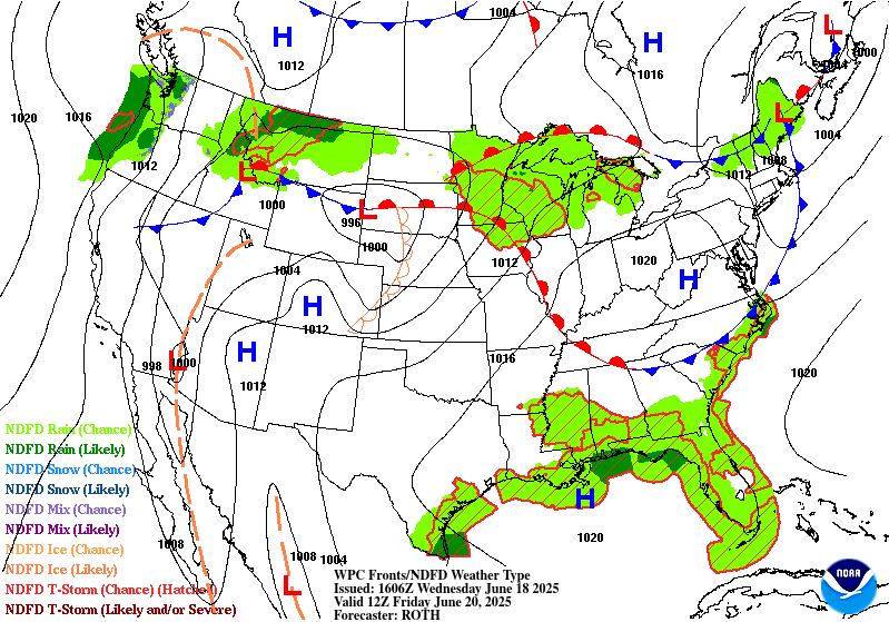
Day 2
Valid 12Z Thu Jun 19 2025 - 12Z Fri Jun 20 2025
...THERE IS A MARGINAL RISK OF EXCESSIVE RAINFALL FROM THE MID-
SOUTH THROUGH INTERIOR NEW ENGLAND...
Mid-level trough axis initially positioned across the Mississippi
Valley will become more progressive on Thursday as it weakens in
response to an expanding ridge over the Southern Plains. As this
trough weakens and move quickly towards the Atlantic coast, a
surface cold front beneath it will additionally track eastward,
likely exiting the Mid-Atlantic and New England coasts by Friday
morning, while lingering into the Southeast. This front will
provide a focus for convective development Thursday, especially
during peak heating as downstream SW 850mb flow of 25-35 kts surges
PWs to 1.75+ inches, reflective of an environment that will support
extremely efficient rainfall within thunderstorms. This indicates
that despite the rapid frontal progression, and accompanying
forward motion of thunderstorms (0-6km mean winds 20-25 kts),
intense rainfall rates of 1-2"/hr could still produce isolated
impacts, especially where any repeating storms can occur, or if
heavier rain falls atop urban areas or more sensitive soils.
At this time no SLGT risks have been introduced as storm motions
may be more perpendicular to the front, and thus, mostly
progressive. However, there is at least a subtle signal for some
heavier rainfall across the Central Appalachians. This area is
extremely sensitive due to recent heavy rainfall (7-day rainfall
150-300 percent of normal) which has primed soils and reduced FFG
to 1-2"/3hrs. If this signal increases, a targeted SLGT risk may be
needed across these most vulnerable areas.
Weiss
Day 2 threat area:
www.wpc.ncep.noaa.gov/qpf/98epoints.txt
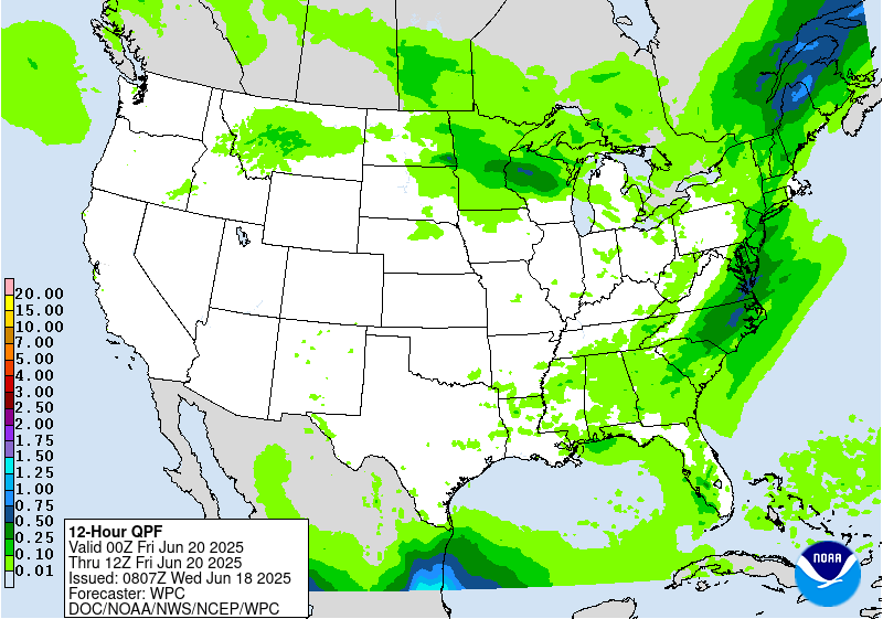
Excessive Rainfall Discussion
NWS Weather Prediction Center College Park MD
408 AM EDT Wed Jun 18 2025
Day 3
Valid 12Z Fri Jun 20 2025 - 12Z Sat Jun 21 2025
...THERE IS A MARGINAL RISK OF EXCESSIVE RAINFALL FOR THE NORTHERN
GREAT LAKES AND PORTIONS OF THE NORTHERN ROCKIES...
...Northern Great Lakes...
Low pressure emerging from the Northern High Plains will extend a
warm front downstream and into the Upper Midwest/Great Lakes. As
this warm front lifts steadily northeast, especially the latter
half of D3 /Friday night/, it will serve as a focus for blossoming
convection. The downstream amplifying 850mb flow lifting out of the
Gulf will reach as high as 40-50 kts into the Upper Midwest, and
with the presence of the low to the west, these winds will back
steadily to the SE to surge higher PWs, approaching 1.75 inches,
into the warm front and into MN/WI. The combination of moisture
convergence and isentropic ascent invof this front will help expand
clusters of thunderstorms Friday night, leading to an axis of heavy
rain that has a modest potential (10% or less from the ECENS/SREF)
of exceeding 3 inches. Despite high FFG across this region,
isolated flash flooding could result from this rainfall.
...Northern Rockies...
Extremely anomalous mid-level low will dig into the Pacific
Northwest Friday, pushing 500mb heights to below the 00Z minimum of
the climatological database from NAEFS. Where intense height
falls/PVA combine with the increasing diffluence along the LFQ of a
Pacific jet streak, surface pressure falls will result, leading to
a deepening low pressure moving from ID into MT. The increasingly
backed low-level flow ahead of this system will cause 850mb winds
to surge out of the E at 15-25 kts, lifting favorably to upslope
into the terrain while additionally transporting a ribbon of PWs
above 1 inch into the High Plains and banking into the eastern side
of the Rockies. This will cause expanding precipitation, with
embedded rainfall rates above 0.5"/hr where a narrow corridor of
instability exists over northern MT. Locally heavy rainfall of
1-2", with locally higher amounts, will result, leading to the
potential for isolated flash flooding atop FFG that is only
1-1.5"/3hrs.
Weiss
Day 3 threat area:
www.wpc.ncep.noaa.gov/qpf/99epoints.txt
Extended Forecast Discussion
NWS Weather Prediction Center College Park MD
300 AM EDT Wed Jun 18 2025
A major synoptic pattern change is in store for the weekend and
into next week as an amplifying upper- level ridge over the
central/eastern U.S. shifts the storm track northward and brings a
period of drier conditions to many after unsettled weather much of
the week. Embedded impulses within the upper-ridge will trigger
convection, potentially organized, across the Upper Great Lakes to
Interior Northeast Saturday (day 4). A Marginal Risk ERO is in
place as a strong low level jet and high PWATs (up to 2 standard
deviations above the mean) support the threat of heavy rainfall and
at least isolated flash flooding. Daily showers and thunderstorms
are also expected in vicinity of the Gulf Coast as disturbances
round the south side of the ridge and with possible influence of
tropical moisture for the western Gulf Coast/south Texas. This
influx of moisture also looks to bring precipitation chances
further northwest into western Texas and the southern high Plains
by later this weekend, with heavy rainfall/flash flooding concerns
especially into Monday - Wednesday as PWATs rise upwards of 2.5-3
standard deviations above the mean.
Upstream, an energetic deep upper-trough/Pacific system and
northern stream into the West will bring increasing precipitation
chances to the Pacific Northwest and northern Rockies/Plains this
weekend in unsettled flow with moderate to heavy rainfall
potential. A Marginal Risk ERO is in place for Saturday (Day 4) for
north-central Montana given a signal for high QPF in the guidance
and the presence of strong, very moist upslope flow behind the
departing cyclone in the northern Plains. Much colder temperatures
aloft will also bring some snowfall to higher elevations of the
northern Rockies, and this precludes a higher threat for flash
flooding in the region for now despite high QPF and anomalously
high moisture. Eventual lead frontal system development over the
Plains will bring a return of thunderstorm chances to portions of
the central/northern Plains and Midwest Sunday and particularly
Monday-Wednesday with moist return flow along a slow moving frontal
boundary. Potential organized convection in southwesterly flow
rounding the ridge may bring daily heavy rainfall/flash flooding
and severe weather threats.
The first significant heat wave of the season is expected to be
expanding in coverage from the central Plains into the
Midwest/Great Lakes by Saturday, and the Ohio Valley/Mid-
Atlantic/Northeast by Sunday thanks to an anomalous upper-level
high building overhead. Widespread Major to Extreme Heat Risk
(levels 3 and 4/4) is forecast, indicating an intensity of heat
that is extremely dangerous to anyone without adequate cooling or
hydration. Heat indices are forecast to climb into the 100-110
degree range, potentially higher, and muggy overnight lows in the
mid- to upper 70s will bring little overnight relief from the heat.
Numerous daily record high and minimum temperatures are possible.
Unfortunately, this heat wave looks to persist through at least the
middle of next week, which will increases the danger. Some
locations from the central Plains into the Upper Midwest may see
some relief by Tuesday as a cold front moves into the region. Highs
will be cooler and below average by as much as 10-20 degrees
across portions of the Pacific Northwest, Great Basin, and northern
Rockies/High Plains this weekend as an upper level trough and
associated surface cold front from the northeast Pacific
overspreads the region.
Putnam


