Extended Forecast Discussion
NWS Weather Prediction Center College Park MD
258 AM EDT Sun Jun 22 2025
Valid 12Z Wed Jun 25 2025 - 12Z Sun Jun 29 2025
...Record heat gradually lessens but dangerous heat continues for
the Ohio/Tennessee Valleys and Mid-Atlantic/Southeast mid to late
week...
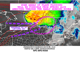
...Heavy rain and flash flooding concerns continue for the north-
central Plains/Upper Midwest Wednesday and Thursday, and lingering
in New Mexico Wednesday...
...Overview...
As the medium range period begins Wednesday, a significant and
extremely dangerous heat wave will be ongoing across the Midwest,
Ohio Valley, and eastern U.S. as a notably strong upper high is
centered from the Ohio/Tennessee Valleys and Mid-Atlantic. The
extreme, record-breaking heat should moderate slowly midweek and
beyond, but temperatures will remain quite hot across those areas,
and the long duration of the heat wave could cause exacerbated
impacts. Meanwhile strong southerly inflow with deep tropical
moisture will set up between the upper high and an initial mean
trough with embedded shortwaves in the West. Moisture will
initially reach New Mexico and lead to additional heavy rain there,
with the moisture then reaching around the upper ridge (in a "ring
of fire" setup). This should interact with a wavy frontal boundary
and promote another area of potentially heavy rain and flash
flooding over the north-central Plains, Corn Belt/Midwest, and
Great Lakes region.
...Guidance/Predictability Assessment...
The large scale pattern remains in excellent agreement for
midweek, as models for several days have shown a 594+ dm upper
ridge lasting through Wednesday, and weakening and flattening after
that. Meanwhile farther west, troughing across the Great Basin and
vicinity will also weaken as the week progresses. This, combined
with a wave train of northern stream shortwaves, will trend the 500
mb flow pattern toward more zonal and less amplified flow for the
latter half of the week. The slight differences in speed and
amplitude of multiple shortwaves streaming from the West to the
Upper Midwest introduces a bit more uncertainty for the mid to late
medium range period, but nothing out of the ordinary at that time
range. Somewhat broader scale troughing moving into the Northwest
late week and progressing eastward into the weekend shows some
timing and amplitude differences. The 12/18Z GFS runs were weaker
and progressive than the non-NCEP and AI/ML consensus with this
trough, so the GFS runs were not favored. The new 00Z GFS seems to
show better agreement though.
The WPC forecast for mass fields was based on a general multi-
model blend early in the period. Increasing model differences and
eventually eliminating the 12/18Z GFS from the blend led to
introducing and increasing the proportion of the GEFS and EC
ensemble means in the blend, with the means reaching half the blend
Day 6 and more Day 7. For QPF, mainly leaned toward the pattern of
the EC-AIFS in the north-central U.S. especially on Wednesday, but
with increased amounts. This supported more QPF in Nebraska than
the NBM that favored northeast of there, which seemed to make sense
since Nebraska was closer to the better forcing.
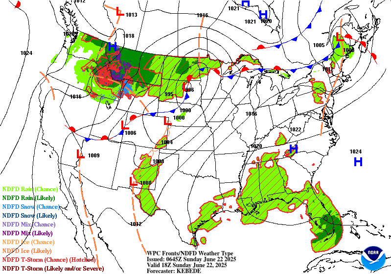
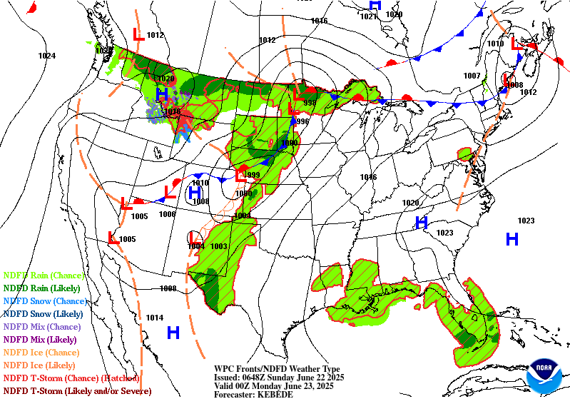
...Weather/Hazards Highlights...
On Wednesday, the upper trough in the Interior West will be
gradually weakening, lessening upper jet right entrance region
support and slightly lessening moisture anomalies in the southern
Rockies/High Plains compared to what's now the short range period.
However, some heavy rain could still be a concern centered around
New Mexico, especially considering the wet antecedent conditions by
then. A Slight Risk is delineated in the Sacramento Mountains and
vicinity for the Day 4/Wednesday ERO, where orographic support
could enhance rainfall totals and where burn scars and steep
terrain make the area sensitive to heavy rain. Rain amounts should
continue to gradually decrease there into later week. Will show a
Marginal Risk on Day 5/Thursday for southern portions of New Mexico
including the Sacramento Mountains for another potential round of
moderate to locally heavy rain.
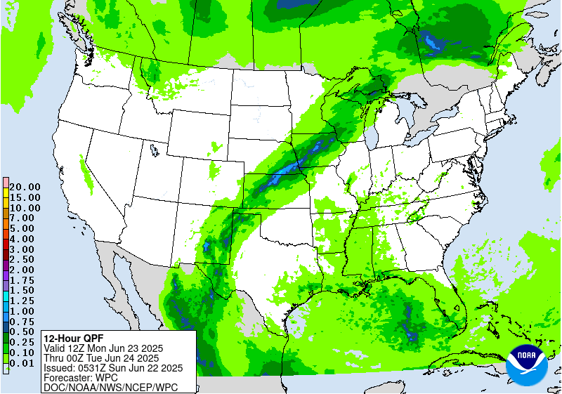
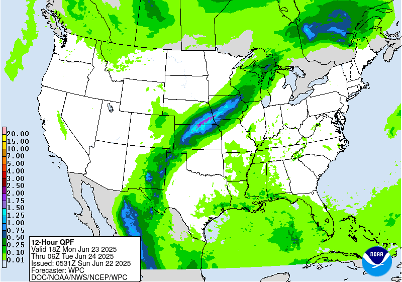
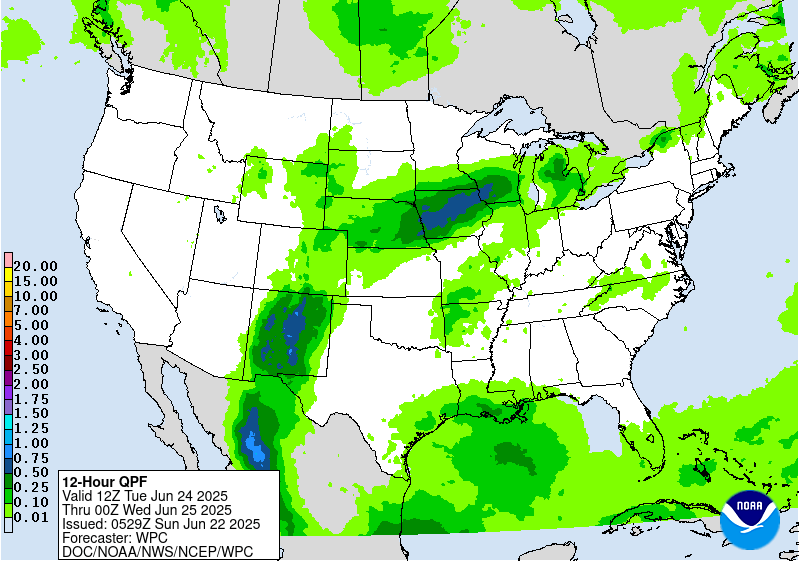
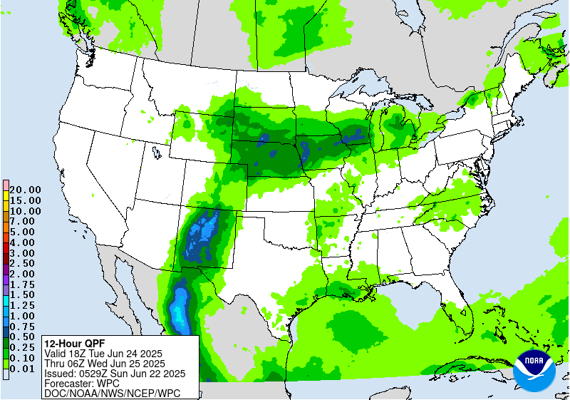
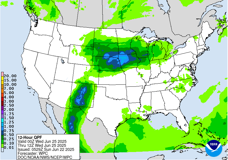
The plume of subtropical/tropical moisture will arc northeastward
into the north-central Plains and Upper Midwest/Corn Belt where the
additional lift around the frontal boundary and potential training
will favor areas of heavier rainfall and some flash flooding
potential. For the Day 4/Wednesday ERO, continue to show a Slight
Risk (with embedded probabilities on the higher end of the Slight
range) for these areas. The Slight generally covers some model
spread from an eastern Nebraska focus to areas farther northeast.
The details in the heavy rainfall placement remain uncertain south
due to the sensitivity to day-to-day rainfall patterns and
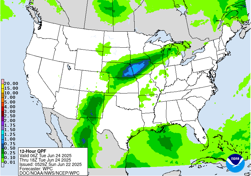
mesoscale boundaries. A weak surface low embedded along the front
may track somewhat east by Thursday, pushing the heaviest rain
totals across much of Wisconsin and possibly the U.P. of Michigan.
Thus for the initial Day 5/Thursday ERO, will show a Slight Risk
there, given potential for 2 to 4 inches to accumulate despite
continued spread in the exact positioning. For both Wednesday and
Thursday, some convection with locally heavy rain could traverse
the northern side of the ridge farther east into New York State and
the northern Mid-Atlantic, so will show Marginal Risks there. The
Northeast may see increasing rain amounts by Friday, while another
round of rain is possible in the north-central U.S. late week as
well.
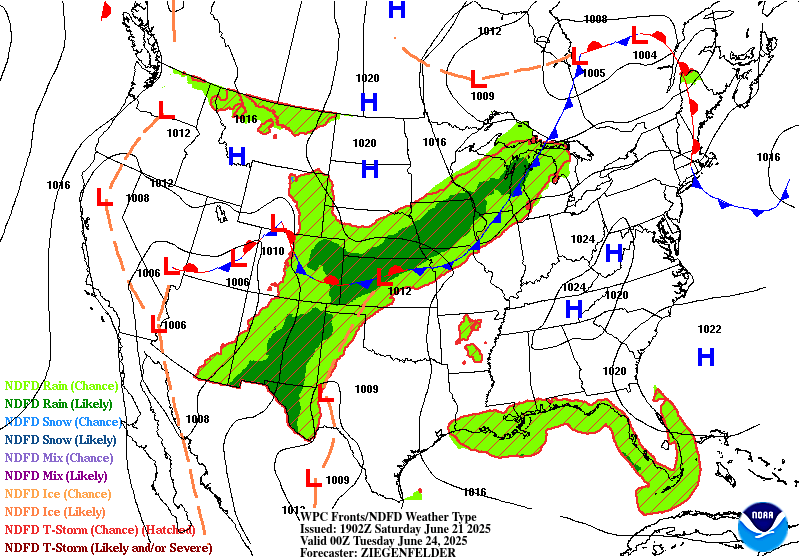
Farther south, there is some uncertainty with how much convection
may occur under the upper ridge across the Gulf Coast and
southeastern U.S. as surface-based instability likely battles with
subsidence aloft. In general, scattered thunderstorms may increase
in coverage as the week progresses as the upper high gradually
weakens.
The strong upper high/ridge stretching across the south-central to
eastern U.S. will allow for well above average temperatures that
could approach or exceed daily records at a few dozen locations
through Wednesday, with more widespread coverage of record warm
morning lows if those numbers hold through the calendar day. This
translates into highs well into the 90s into the low 100s, with
heat indices to near 110F as dew points will be in the 60s to
low/mid-70s. Overnight lows will only drop into the low/mid 70s for
many areas, and even may stay around 80-83F in the urban centers
like Washington, D.C., Baltimore, Philadelphia, and New York City.
This will bring little relief from the heat and exacerbate
potential impacts. Thus, HeatRisk values will be Major to Extreme
for portions of the Midwest and Ohio Valley to Eastern states --
levels 3 and 4 on a scale from 1 to 4 (4 being Extreme). This
indicates an intensity and duration of heat that is extremely
dangerous to anyone without adequate cooling or hydration. Extreme
heat is the number 1 weather-related killer -- please take
precautions if you are outside during the hottest part of the day
and seek cooling if you are without adequate means. Temperatures
will remain above average, though a few degrees lower and with
fewer records possible, across much of the Ohio Valley/Mid-
Atlantic/Southeast into the latter part of next week. But the
Northeast should see moderating temperatures after a cold frontal
passage. Meanwhile, temperatures (particularly highs) are forecast
to be below average by a few degrees in the High Plains into
midweek, but the West should gradually warm to a bit above average
as the week progresses.
Tate
Additional 3-7 Day Hazard information can be found on the WPC
medium range hazards outlook chart at:
https://www.wpc.ncep.noaa.gov/threats/threats.php
WPC medium range 500mb heights, surface systems, weather grids,
quantitative precipitation forecast (QPF), excessive rainfall
outlook (ERO), winter weather outlook (WWO) probabilities, heat
indices, and Key Messages can be accessed from:
https://www.wpc.ncep.noaa.gov/medr/5dayfcst500_wbg.gif
https://www.wpc.ncep.noaa.gov/medr/5dayfcst_wbg_conus.gif
https://www.wpc.ncep.noaa.gov/5km_grids/5km_gridsbody.html
https://www.wpc.ncep.noaa.gov/qpf/day4-7.shtml
https://www.wpc.ncep.noaa.gov/#page=ero
https://www.wpc.ncep.noaa.gov/wwd/pwpf_d47/pwpf_medr.php?day=4
https://www.wpc.ncep.noaa.gov/heat_index.shtml
https://www.wpc.ncep.noaa.gov/#page=ovw


