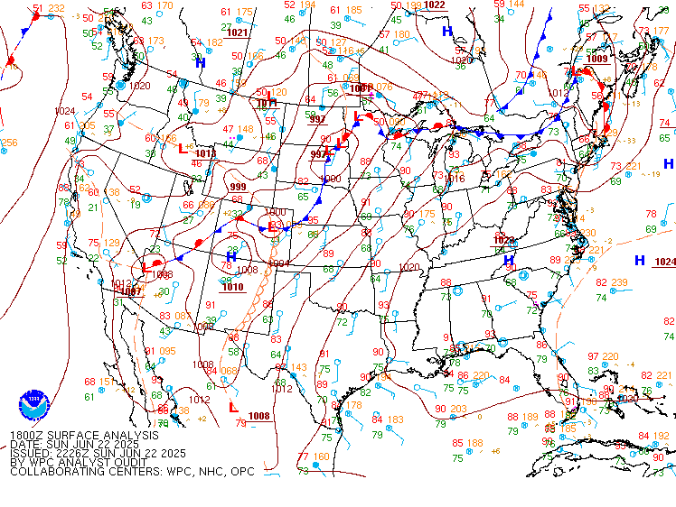
Excessive Rainfall Discussion
NWS Weather Prediction Center College Park MD
1155 AM EDT Mon Jun 23 2025
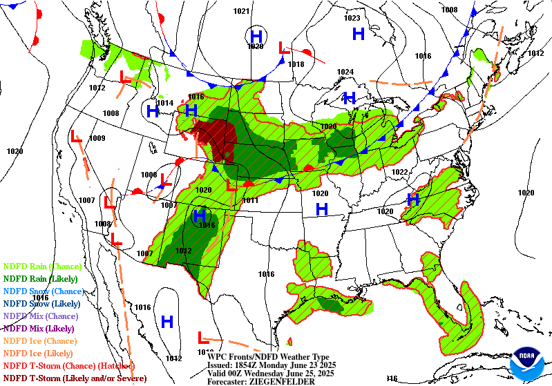
Day 1
Valid 16Z Mon Jun 23 2025 - 12Z Tue Jun 24 2025
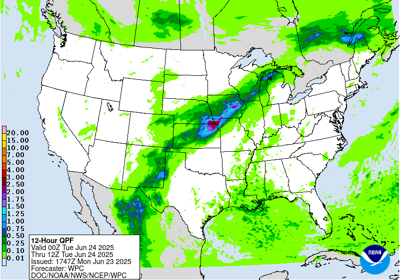
...THERE IS A SLIGHT RISK OF EXCESSIVE RAINFALL ACROSS PORTIONS OF
NEW MEXICO AND WEST TEXAS, AND FROM KANSAS INTO SOUTHERN
WISCONSIN...
16Z Excessive Rainfall Discussion Update...
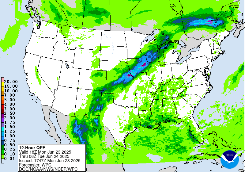
Based on the 06Z neighborhood probabilities...and a quick look at
the probabilities from the 12Z run...extended the Slight Risk area
a bit to the east to cover more of southern Wisconsin. In the
broader picture...the risk of excessive rainfall exists on the
periphery of a broad upper level ridge from New Mexico and West
Texas...across the Central Plains into the Upper Midwest given the
persistent deep-layer advection and embedded shortwave energy. The
12Z HREF probabilities aligned well with the previously issued
Excessive Rainfall Outlook and only minor adjustments were needed.
Bann
...New Mexico into West Texas...
A general pattern of persistence will maintain a relevant posture
for scattered to widespread convective impacts across Southwestern
TX up through the eastern half of NM with the highest potential
impacts aligned within the terrain. Ample moisture advection
provided by prevailing southerly-oriented flow within the sfc-500mb
layer will correlate with an environment capable of locally heavy
rainfall within any cell maturation across the above areas. The
proxy of the deep layer moisture and RER jet dynamics from the mean
trough situated to the west will create an accumulated risk of
showers and storms propagating over the same areas leading to
increasingly compromised soils, or even interacting with the
already prevalent burn scars situated over the Sacramento Mtns.
Storm motions will likely be fairly weak as noted by the forecast
Corfidi vectors residing between 5-15kts on average within the
confines of the entire Southwest TX and Southeast NM domains. This
will allow for modest training concerns that will ultimately cause
problems if they fall within any of the urban centers along the
Upper Trans Pecos out into the complex topography located in the
region. The best chance for flash flooding will likely be within
those burn scar locations where hydrophobic soils are still a
problem and can promote a formidable runoff regime that could cause
significant problems locally if a heavy cell forms overhead. Areas
within the Pecos river are also notorious for flash flooding
capabilities due to the limited drainage structures prevalent
within town limits. Considering the HREF neighborhood probs for >2"
are running between 50-90% over a large area extending from the
Davis Mtns up through the Eastern NM Caprock, the previous SLGT
risk was upheld with wording of a higher end SLGT considering the
environment in place.
...Central Plains to Midwest...
The Central Plains through the Midwest continues to lie within the
northern and northwest periphery of a broad ridge extension
centered over the Mid Atlantic. The proxy of the ridge has allowed
for a persistent south to southwesterly mean flow within the
column leading to steady moisture advection within the boundary
layer up to around 500mb. Current PWATs from 00z RAOB analysis
across the Plains and Mississippi Valley denote moisture anomalies
that are approaching +2 deviations, something that has also been
reflected in the last several days of NAEFS anomalies within the
ensemble suite. The relevant moisture pooling across the zone
extending from KS up into the Midwest will lead to a formidable
widespread convective initiation scheme that will develop due to
increased convergence along and ahead of a slow-moving cold front
nosing down through the Northern Plains. The interaction of the
cold front with a very buoyant environment (MUCAPE 2500-4000 J/kg)
located across the Central Plains up into the Upper Mississippi
Valley will create a broad axis of heavy convection with the
heaviest precip likely correlated with the 2+" PWAT domain located
from North-Central KS and points northeast into IA.
There's a general consensus within the latest CAMs suite of
significant totals between 2-4" forecast located within the
aforementioned zone, including some deterministic output and lower
neighborhood prob correlation for some places exceeding 5". The
prospects for those types of totals stems from not only the
favorable deep moist convective pattern, but also the mean layer
flow and surface convergence regime along the front creating a
favorable environment for back-building convection and training
cell prospects. This is fairly well-documented when assessing
forecast Corfidi Vectors continuing this divergent storm motion
setup within the upshear and downshear calculations given the
forecast wind field(s). A strong RER jet dynamic will only aid in
a blossoming QPF field and maintenance as the mean flow takes the
convective pattern off to the northeast. This pattern will carry
through Monday evening into early Tuesday morning with some
weakening of the convective field anticipated due to loss of
diurnal destabilization. In any case, this setup is capable of
widespread 1-2" totals with the hardest hit locations likely seeing
2-4" with locally higher as noted in the latest CAMs. The saving
grace, at least initially for D1, are the drier soils centered over
the Central Plains into parts of Southeast NE and Southwest IA
leading to higher FFG indices that will need some priming in order
to likely reflect a more significant flash flood response.
The change from the previous forecast was an adjustment to the
south with the overall SLGT risk as guidance reflects a bit of a
faster frontal progression than anticipated. This places a higher
risk a bit south over Northeast KS to points northeast. The threat
for locally heavy rainfall is also forecast across Southwest KS
with cells ejecting out of the High Plains of CO/NM, but CAMs are
less defined due to the lack of a boundary layer focus
comparatively. The MRGL exists in at particular area, but if CAMs
come into agreement on a local max centered near or southwest of
DDC, then the SLGT risk may be extended further to the southwest to
account for the prospect.
Kleebauer
Day 1 threat area:
www.wpc.ncep.noaa.gov/qpf/94epoints.txt
Excessive Rainfall Discussion
NWS Weather Prediction Center College Park MD
1155 AM EDT Mon Jun 23 2025
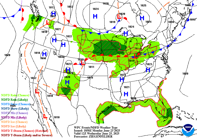
Day 2
Valid 12Z Tue Jun 24 2025 - 12Z Wed Jun 25 2025
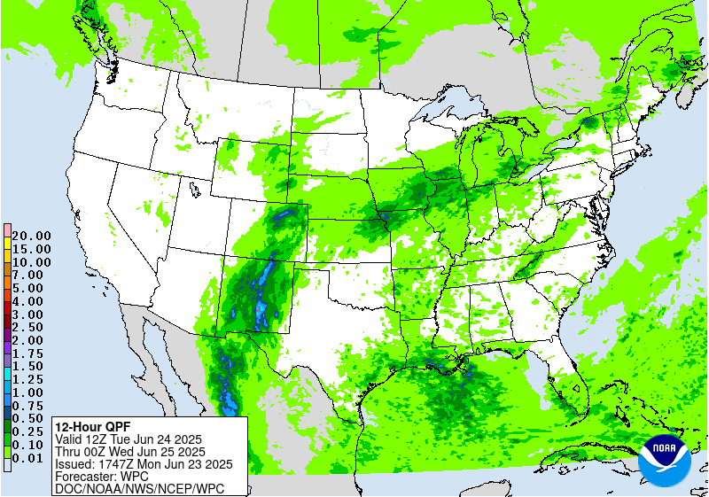
...THERE IS A MODERATE RISK OF EXCESSIVE RAINFALL OVER PORTIONS OF
CENTRAL NEW MEXICO...
...New Mexico...
Upper level pattern will be in a short transitory phase, but one
that will ultimately lead to a threat of prolonged heavy rainfall
from training convection across much of the terrain in Southern and
Central NM. The massive ridge to the east will flex further as we
head into Tuesday with the higher heights on the western fringes
pushing back west beyond the eastern portions NM. A steady north-
south progression within the mid and upper levels will send
numerous smaller shortwave perturbations poleward with anticipated
motions into the Sacramento's, eventually north into the Sangre de
Cristos by the late-afternoon and evening period on Tuesday.
Moisture remaining parked over the region coupled with the focused
ascent and narrow upslope proxy within the Sacramento Mtns. will
lead to a corridor of heavy convection remaining situated in-of
the terrain. There's a growing consensus within all deterministic
that local topographic effects within this pattern will yield some
significant rainfall potential over areas that are prone to flash
flooding, especially with the burn scars still present near Ruidoso
creating higher runoff capabilities. 00z HREF depicted between 2-3"
of rainfall in just the 12-hr period between 12-00z on Tue/Wed with
precip continuing at the end of the run. Ensemble mean forecast
within the NWP suite was up around 3" for multiple locations with a
large areal coverage of at least 2" within the mean output. These
are generally signals that favor not only flash flooding prospects,
but widespread flash flood concerns with more significant impacts
possible.
The signal for heavy rainfall continues all the way up into the
Sangre de Cristos where the afternoon and evening time frames call
for widespread heavy thunderstorm activity aligned with the ridges
of the southern Rockies. These areas also have burn scar prevalence
that could exacerbate flash flood risks as runoff capabilities are
maximized. Considering the anticipated threat bleeding further
north within the guidance this evening, the previous MDT risk was
expanded northward to encompass those areas within the Sangre de
Cristos and neighboring valleys. The threat for a targeted higher
risk over the Sacramento's is plausible if this signal remains for
another forecast cycle or two. As of now, it is deemed closer to a
high-end MDT risk with the area across the northern Sacramento's
the most susceptible to significant impact potential.
...Central Plains to Midwest...
The pattern across the Plains and Midwest that will bring heavy
rainfall to those areas Monday night into Tuesday morning will
bleed over into the D2 period with ongoing precip likely across
Northeast KS into adjacent areas of NE/MO/IA. Flash flooding
concerns will be ongoing at this time and recent CAMs output is
signaling more rainfall through at least 18z will continue to
plague those same areas. 00z HREF neighborhood probs over the 12hr
period between 12-00z Tue/Wed denote a 40-60% chance of exceeding
2" over areas that will have already seen significant (2-4+")
rainfall the period prior. Rates ~1"/hr are modest within the hi-
res ensemble probability fields as well, a testament to the
persistence in the heavy convective setup in place. There will
finally be less of a concern late in the afternoon as the frontal
progression migrates north the second half of the period, so the
threat will likely be more focused in that area the first half of
the forecast. Still, this is enough for a continued SLGT risk with
higher end risk potential given the period overlap.
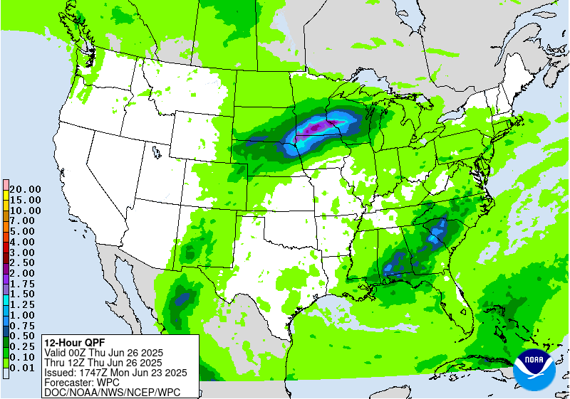
The setup the following evening becomes trickier as the entire
evolution comes down to the handling of the mid-level energy riding
northeast out of the Southern Plains into the Central Plains and
Upper Midwest after nightfall. Surface front from the prior period
will eventually hit a roadblock on its southern progression and
flip back to a warm front as it migrates back to the north under
the guide of a potent LLJ generation across the Plains. The
interaction between the front and the energy will create a
secondary convective enhancement that will impact areas further
north than the previous 36 hrs. The lack of overlap may inhibit
significant impacts, however the training threat within the
confines of the boundary may be enough to warrant some higher risk
of flash flooding. The setup is depicted by guidance in the 00-12z
period Wednesday, but position of the heaviest precip is seemingly
all over the place. The threat is certainly there for 2-4" with
locally higher, but specifics still remain sort of muddled. The
SLGT risk prior was adjusted to reflect the ensemble mean QPF
distribution with a heavy precip footprint still located over far
Southeast SD into Southern MN for the period. How far north the
front migrates and handling of the shortwave ejection will
determine exactly where the heaviest precip will occur. Right now,
anywhere within the SLGT risk is fair game, so it's a time frame to
monitor closely.
Kleebauer
Day 2 threat area:
www.wpc.ncep.noaa.gov/qpf/98epoints.txt
Excessive Rainfall Discussion
NWS Weather Prediction Center College Park MD
1155 AM EDT Mon Jun 23 2025
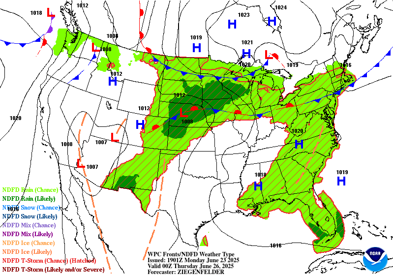
Day 3
Valid 12Z Wed Jun 25 2025 - 12Z Thu Jun 26 2025
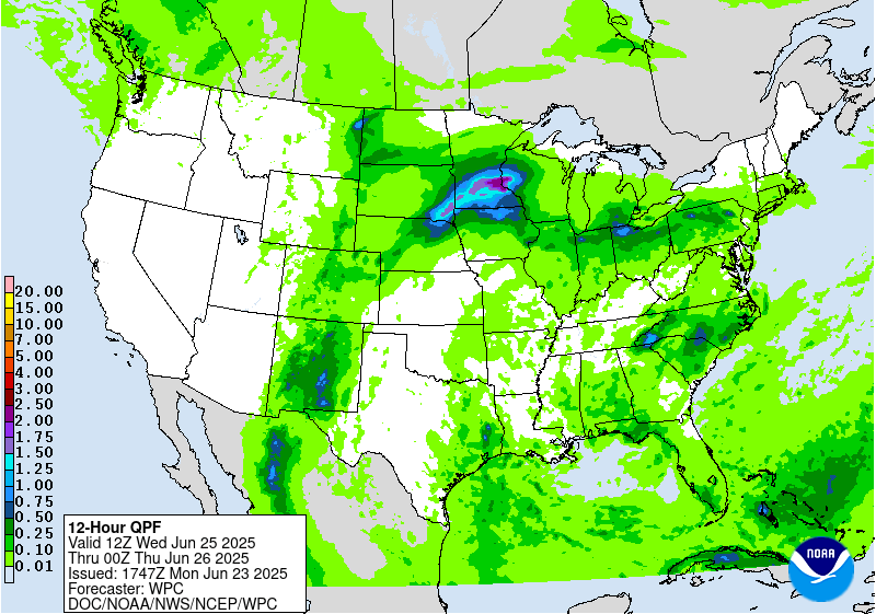
...THERE IS A SLIGHT RISK OF EXCESSIVE RAINFALL OVER PORTIONS OF
NEW MEXICO, CENTRAL PLAINS AND MIDWEST...
...New Mexico...
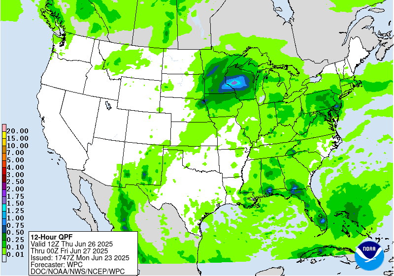
Unlike the prior periods, the D3 is finally the downward trend to
the incessant nature of scattered to numerous thunderstorms that
will plague the state, especially across the Sacramento's and
Sangre de Cristos. Despite the lower coverage anticipated,
scattered thunderstorms are still plausible in the afternoon as
ample heating during prime destabilization window (16-21z) will
yield another threat of thunderstorms across the terrain and
adjacent valleys. Current signals are nowhere near as robust as the
D1/D2 time frames, but with potentially significant impacts prior,
there's a greater threat of truly compromised FFG's leading in
allowing for the bar to be very low for flash flooding. As of now,
the ensemble mean is still highlighting the Sacramento's up into
the I-40 corridor as the main areas of concern. A SLGT risk was
maintained and expanded a bit to encompass the zones of greatest
risk for flash flooding. A targeted higher risk is not out of the
question for the Sacramento's, but will assess in later forecasts
as we monitor how everything evolves leading into the D3.
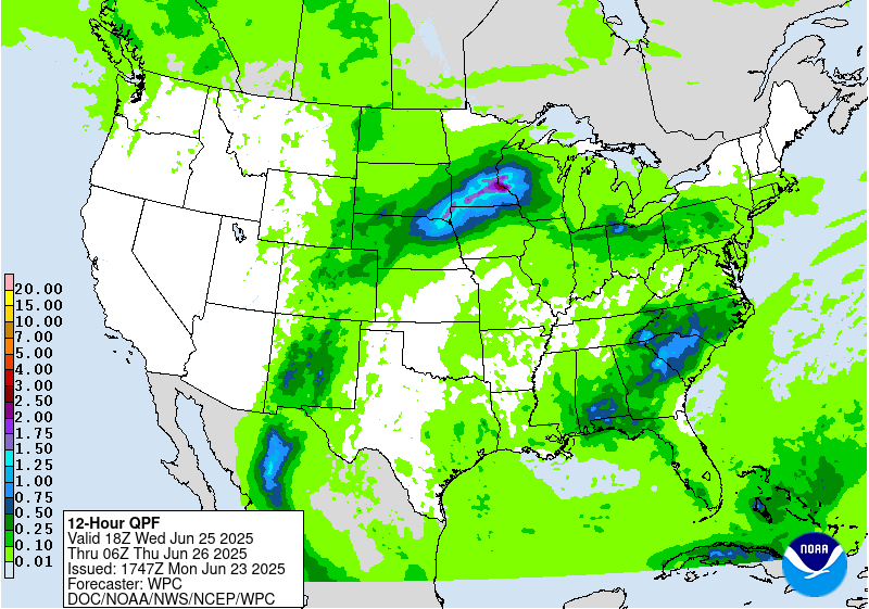
...Central Plains to Midwest...
Unlike the prior period where there is some uncertainty in the
handling of shortwave energy and frontal positioning, there's a
pretty good consensus brewing on the pattern converging in-of the
Upper Midwest with sights on MN into Western WI as the evolution in
D2 carries over into D3. Mean QPF output via ensembles is running
between 2-4" for an areal average with the maxima positioned across
Southern MN back into adjacent areas of SD/NE to the southwest. Not
one, but two waves of convection will encroach the area with some
spots potentially seeing some significant rainfall (>2") in both
waves which will likely lead to scattered, bordering widespread
flash flood prospects due to the compounding rainfall forecast. NBM
90th percentile QPF is well over 2" across much of the
aforementioned region with some higher totals even extending back
through NE. As of now, it's still a bit early for the higher risks
due to some uncertainty the day prior which could shift the
forecast a bit in either direction (north or south). For now,
maintained a higher end SLGT across a large portion of the Upper
Midwest with the eastern extension pushing all the way out into
Northern WI. A targeted higher risk is certainly in the cards if
this signal remains and consensus grows on the evolution of the
synoptic details.
Kleebauer
Day 3 threat area:
www.wpc.ncep.noaa.gov/qpf/99epoints.txt
Extended Forecast Discussion
NWS Weather Prediction Center College Park MD
232 PM EDT Mon Jun 23 2025
On Thursday, some anomalously high tropical and subtropical
moisture should still be filtering into New Mexico. However, with
the upper trough in the Interior West weakening, there will be less
upper level support for widespread convection compared to the
short range period. Regardless, heavy rain could still be a concern
in New Mexico, especially considering the wet antecedent
conditions by then. Will maintain Marginal Risks in the Days 4/5
(Thursday/Friday) EROs with a particular focus on the Sacramento
Mountains, where orographic support could enhance rainfall totals
and where burn scars and steep terrain make the area sensitive to
heavy rain. Some showers and storms are possible there into the
weekend.
The plume of moisture will arc northeastward into the Upper
Midwest/Great Lakes region, where the additional lift around a weak
surface low and frontal boundary in the vicinity and potential
training will favor areas of heavier rainfall and some flash
flooding potential. For the Day 4/Thursday ERO, continue to show a
Slight Risk across the Upper Midwest/much of Wisconsin and the U.P.
of Michigan, given potential for 2 to 4 inches to accumulate
despite continued spread in the exact positioning. Some convection
with locally heavy rain could traverse the northern side of the
ridge farther east into New York State and the northern Mid-
Atlantic, and have captured these areas within the Marginal Risk on
Thursday. By Friday the surface low/frontal system will continue
to track east, bringing some potentially enhanced rain amounts to
the Lower Great Lakes region and Interior Northeast. There still
remains some uncertainty with the positioning of the heaviest QPF,
including some models showing the heaviest rain staying in Canada,
so will maintain a Marginal Risk in the Day 5/Friday ERO rather
than introducing a Slight Risk for this cycle. That being said,
will
continue to monitor trends since some of the higher terrain there
can be sensitive to heavy rainfall. Meanwhile, another shortwave
may move through the north-central U.S. while instability is
likely to be high (MUCAPE of 3000-5000 J/kg already shown by the
global models). Have a Marginal Risk delineated in parts of the
Dakotas to Minnesota since locally heavy rain rates are likely in
this unstable atmosphere.
Scattered showers and thunderstorms will become more widespread
across much of the eastern third of the country through the period.
A weak upper low may track across Florida and vicinity on
Thursday-Friday and provide additional support for convection.
Will continue to hold off on introducing any ERO risk areas for
the time being given lower end QPF with relatively high flash
flood guidance. Scattered convection is also likely across the
Appalachians and into the Eastern Seaboard each day as the heat
creates an unstable airmass.
The strong upper high/ridge stretching across the south-central to
eastern U.S. will weaken somewhat into late week, but remain
generally in place, maintaining hot temperatures albeit slightly
moderated from the short range period and less likely to break
records. Nevertheless, temperatures will be well into the 90s in
many central and eastern areas, while dewpoints in the 70s will
raise heat indices into the 100s. Overnight lows will only drop
into the low/mid 70s for many areas, bringing little relief from
the heat and exacerbating potential impacts. Especially after the
extreme heat in the short range, through late week HeatRisk values
will be Major to Extreme for portions of the Midwest and Ohio
Valley to Eastern states -- levels 3 and 4 on a scale from 1 to 4
(4 being Extreme). This indicates an intensity and duration of heat
that is extremely dangerous to anyone without adequate cooling or
hydration. Extreme heat is the number 1 weather-related killer --
please take precautions if you are outside during the hottest part
of the day and seek cooling if you are without adequate means.
Temperatures may continue to slowly moderate into the weekend for
closer to normal summer heat. Elsewhere, the Northeast should see
relief from the heat by the medium range period behind a backdoor
front. The north-central U.S. can expect warmer than average
temperatures by 5 to 10 degrees around Friday-Saturday and then
cool behind a cold front. Temperatures in the Northwest will warm
by early next week under an upper ridge. The Desert Southwest can
expect typical summer heat with temperatures in the 100s and 110s.
Miller/Tate


