


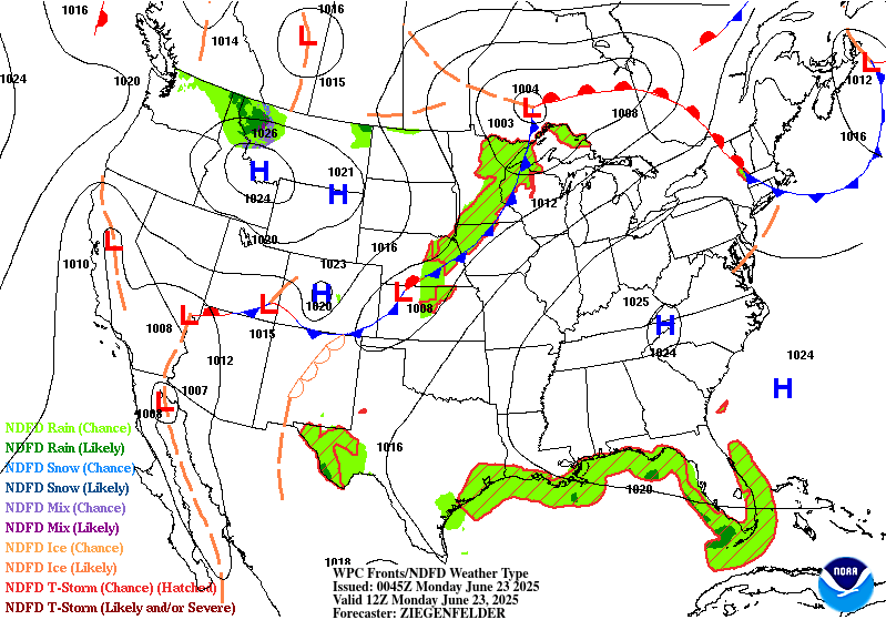
Valid Sun Jun 22, 2025
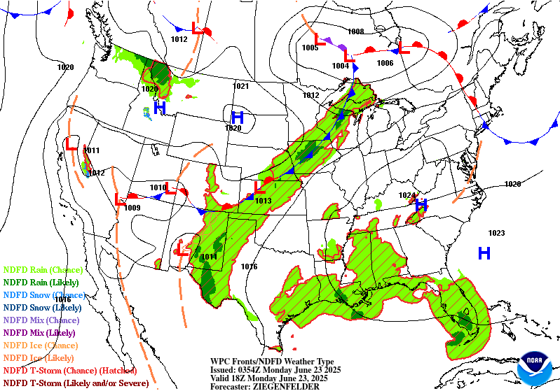
Valid Mon Jun 23, 2025
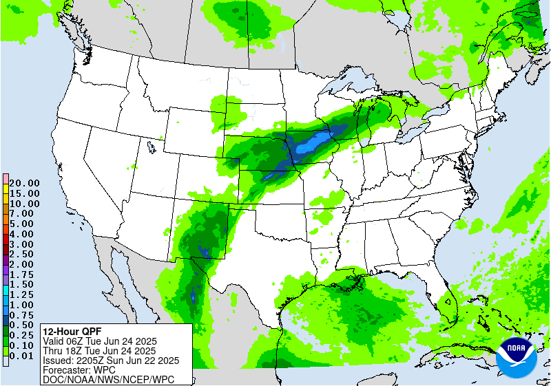
Valid Tue Jun 24, 2025


+ Additional Links
- » Description of the National Forecast Chart
- » Product Archives
- » Download hazards in KML or shapefile format or GeoJSON format


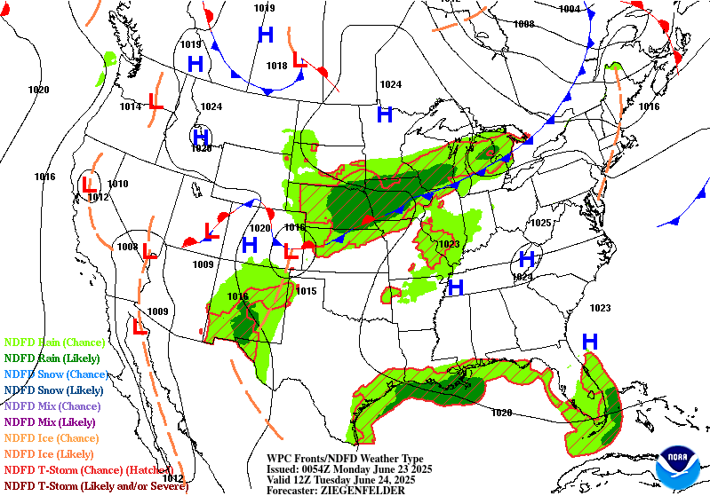


NWS Weather Prediction Center College Park MD
401 PM EDT Sun Jun 22 2025
Valid 00Z Mon Jun 23 2025 - 00Z Wed Jun 25 2025
...There are Extreme Heat Warnings and Heat Advisories across much of the
eastern third of the country...
...There is a Moderate Risk of excessive rainfall over parts of the
Southern Rockies on Tuesday...
...There is a Slight Risk of excessive rainfall over parts of southwestern
Texas, southeastern New Mexico, and northern Mid-Atlantic on Sunday, as
well as Upper/Middle Mississippi Valley/Central Plains and Southern
Rockies/Southern High Plains on Monday...
...There is a Slight Risk of severe thunderstorms over parts of the
Northern Plains, and Central/Southern High Plains/Upper Mississippi Valley
and northern Mid-Atlantic on Sunday as well as Upper Great Lakes,
Upper/Middle Mississippi Valley, and Central Plains on Monday...
There is an upper-level high over the Ohio Valley that will be
quasi-stationary through Tuesday that will contribute to Extreme Heat
Warnings and Heat Advisories across much of the eastern third of the
country. Extreme heat shifts east over the Midwest and Great Lakes on
Sunday and expands to the East Coast by Monday. Light winds, sunny days,
record-high daytime, and high overnight temperatures will create a lack of
overnight cooling, significantly increasing the danger. This heat level
can be dangerous to anyone without effective cooling and/or adequate
hydration, especially those engaging in lengthy outdoor activities.
Heat-related illnesses increase significantly during extreme heat. Wear
lightweight and loose-fitting clothing. Take action when you see symptoms
of heat exhaustion and heat stroke.
In addition, a front extending from the Upper Great Lakes to the
Northern/Central Plains and Central Rockies and then into the Great Basin
will move slowly eastward to the Lower Great Lakes, the Middle Mississippi
Valley, and Central Plains by Tuesday evening. Moisture pooling along the
boundary and east of the dryline will produce showers and severe
thunderstorms from the Northern Plains and Central/Southern High
Plains/Upper Mississippi Valley. Therefore, the SPC has issued a Slight
Risk (level 2/5) of severe thunderstorms over parts of the Northern Plains
and Central/Southern High Plains/Upper Mississippi Valley through Monday
morning. The hazards associated with these thunderstorms are frequent
lightning, severe thunderstorm wind gusts, hail, and a few tornadoes.
Moreover, there will be an increased threat of severe thunderstorm wind
gusts of 65 knots or greater and hail two inches or greater over parts of
the Upper Mississippi Valley.
Furthermore, moisture will stream northwestward over Texas and interact
with upper-level energy to produce showers and thunderstorms, creating
heavy rain over parts of southwestern Texas and southeastern New Mexico.
Therefore, through Monday morning, the WPC has issued a Slight Risk (level
2/4) of excessive rainfall over parts of southwestern Texas and
southeastern New Mexico. The associated heavy rain will create mainly
localized areas of flash flooding, with urban areas, roads, small streams,
and low-lying areas the most vulnerable.
Moreover, upper-level energy over the Northeast and moisture rounding the
periphery of the upper-level ridge will produce showers and severe
thunderstorms with heavy rain over parts of the northern Mid-Atlantic.
Therefore, the WPC has issued a Slight Risk (level 2/4) of excessive
rainfall over parts of the northern Mid-Atlantic through Monday morning.
The associated heavy rain will create mainly localized areas of flash
flooding, with urban areas, roads, small streams, and low-lying areas the
most vulnerable.
Additionally, the SPC has issued a Slight Risk (level 2/5) of severe
thunderstorms over parts of the northern Mid-Atlantic through Monday
morning. The hazards associated with these thunderstorms are frequent
lightning, severe thunderstorm wind gusts, hail, and a few tornadoes.
Moreover, on Sunday, moisture and upper-level impulses will trigger
showers and thunderstorms over parts of the Southern Ohio/Tennessee
Valleys and the Lower Mississippi Valley/Southeast.
On Monday, moisture will continue to flow along the front over the Upper
Great Lakes, Upper/Middle Mississippi Valley, and Central Plains,
producing showers and severe thunderstorms in the areas. Therefore, the
SPC has issued a Slight Risk (level 2/5) of severe thunderstorms over
parts of the Upper Great Lake/Upper/Middle Mississippi Valley and Central
Plains from Monday through Tuesday morning. The hazards associated with
these thunderstorms are frequent lightning, severe thunderstorm wind
gusts, hail, and a few tornadoes.
Furthermore, the showers and thunderstorms will produce heavy rain
covering parts of the Upper/Middle Mississippi Valley and Central Plains.
Therefore, the WPC has issued a Slight Risk (level 2/4) of excessive
rainfall over parts of the Upper/Middle Mississippi Valley and Central
Plains from Monday through Tuesday morning. The associated heavy rain
will create mainly localized areas of flash flooding, with urban areas,
roads, small streams, and low-lying areas the most vulnerable.
A second area of heavy rain will develop over parts of the Southern
Rockies and Southern High Plains. Therefore, the WPC has issued a Slight
Risk (level 2/4) of excessive rainfall over parts of the Southern Rockies
and Southern High Plains from Monday through Tuesday morning. The
associated heavy rain will create mainly localized areas of flash
flooding, with urban areas, roads, small streams, and low-lying areas the
most vulnerable.
Moisture and daytime heating will also produce showers and thunderstorms
on Monday over most of the eastern third of the country.
Elsewhere, on Sunday, upper-level energy over the Northern Rockies will
help produce showers and thunderstorms over parts of the Northern
Intermountain Region and Northern Rockies, which will taper off by Monday.
On Tuesday, moisture will continue to stream over the Southern
Rockies/Southern High Plains into the Central Plains/Middle Mississippi
Valley. The moisture and energy will produce showers, thunderstorms, and
heavy rain over the Southern Rockies. Therefore, the WPC has issued a
Moderate Risk (level 3/4) of excessive rainfall over parts of the Southern
Rockies on Tuesday. Numerous flash flooding events are possible. In
addition, many streams may flood, potentially affecting larger rivers.
Further, heavy rain will develop river parts of the Northern/Central
Plains and Upper /Middle Mississippi Valley on Tuesday. Therefore, the WPC
has issued a Slight Risk (level 2/4) of excessive rainfall over parts of
the Northern/Central Plains and Upper /Middle Mississippi Valley on
Tuesday. The associated heavy rain will create mainly localized areas of
flash flooding, with urban areas, roads, small streams, and low-lying
areas the most vulnerable.
In addition, showers and severe thunderstorms will develop over parts of
the Central High Plains. Therefore, the SPC has issued a Slight Risk
(level 2/5) of severe thunderstorms over parts of the Central High Plains
on Tuesday. The hazards associated with these thunderstorms are frequent
lightning, severe thunderstorm wind gusts, hail, and a few tornadoes.
Ziegenfelder
Graphics available at
https://www.wpc.ncep.noaa.gov/basicwx/basicwx_ndfd.php
NWS Weather Prediction Center College Park MD
243 PM EDT Sun Jun 22 2025
Valid 12Z Wed Jun 25 2025 - 12Z Sun Jun 29 2025
...Record heat gradually lessens but dangerous heat continues for
the Ohio/Tennessee Valleys and Mid-Atlantic/Southeast mid to late
week...
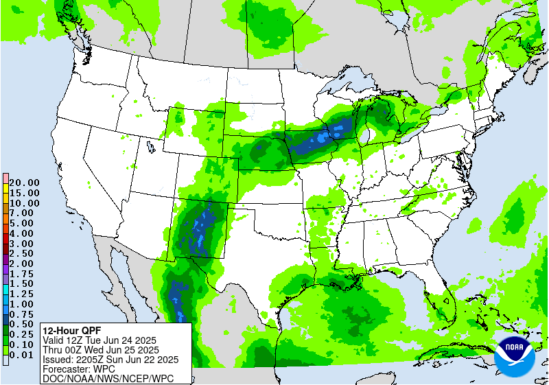
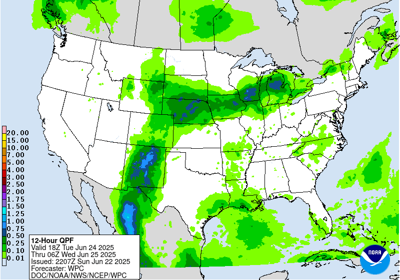
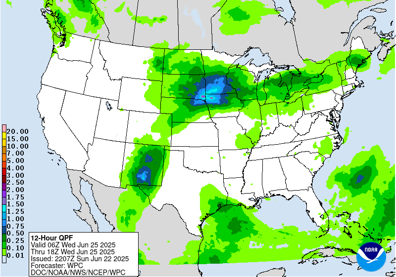
...Heavy rain and flash flooding concerns continue for the north-
central Plains/Upper Midwest Wednesday and Thursday, and lingering
in New Mexico Wednesday...
...Overview...
As the medium range period begins Wednesday, a significant and
extremely dangerous heat wave will be ongoing across the Midwest,
Ohio Valley, and eastern U.S. as a notably strong upper high is
centered from the Ohio/Tennessee Valleys into the Mid-Atlantic. The
extreme, record-breaking heat should moderate slowly midweek and
beyond, but temperatures will remain quite hot across those areas,
and the long duration of the heat wave could cause exacerbated
impacts. Meanwhile strong southerly inflow with deep tropical
moisture will set up between the upper high and an initial mean
trough with embedded shortwaves in the West. Moisture will
initially reach New Mexico and lead to additional heavy rain there
(extending from the short range into the medium range), with the
moisture then reaching around the upper ridge (in a "ring of fire"
setup). This should interact with a wavy frontal boundary and
promote another area of potentially heavy rain and flash flooding
over the north-central Plains, Corn Belt/Midwest, and Great
Lakes/Northeast region.
...Guidance/Predictability Assessment...
The large scale pattern remains in excellent agreement for
midweek, as models for several days have shown a 594+ dm upper
ridge lasting through Wednesday, and weakening and flattening after
that. Meanwhile farther west, troughing across the Great Basin and
vicinity will also weaken as the week progresses. This, combined
with a wave train of northern stream shortwaves, will trend the 500
mb flow pattern toward more zonal and less amplified flow for the
latter half of the week. The slight differences in speed and
amplitude of multiple shortwaves streaming from the West to the
Upper Midwest introduces a bit more uncertainty for the mid to late
medium range period, but nothing out of the ordinary at that time
range. Somewhat broader scale troughing moving into the Northwest
late week and progressing eastward into the weekend shows some
timing and amplitude differences. The 06Z GFS was a bit offset from
the larger cluster of solutions around the 00Z ECMWF with
shortwaves out of the northeastern Pacific, so it was excluded from
the blend by next weekend.
The WPC forecast for mass fields was based on a general multi-
model blend early in the period before sunsetting the GFS in favor
of the ensemble means and continuity. The NBM was sufficient for
most sensible weather grids. For QPF, main challenge was with the
placement and downstream extension of heavier rainfall from NE/IA
up and over the ridge into the Great Lakes and possible
Northeast/Mid-Atlantic. This was encapsulated within the Excessive
Rainfall Outlooks for days 4-5.
...Weather/Hazards Highlights...
On Wednesday, the upper trough in the Interior West will be
gradually weakening, lessening upper jet right entrance region
support and slightly lessening moisture anomalies in the southern
Rockies/High Plains compared to what's now the short range period.
However, some heavy rain could still be a concern centered around
New Mexico, especially considering the wet antecedent conditions by
then. A Slight Risk is delineated in the Sacramento Mountains and
vicinity for the Day 4/Wednesday ERO, where orographic support
could enhance rainfall totals and where burn scars and steep
terrain make the area sensitive to heavy rain. Rain amounts should
continue to gradually decrease there into later week. Maintained a
Marginal Risk on Day 5/Thursday for southern portions of New Mexico
including the Sacramento Mountains for another potential round of
moderate to locally heavy rain.
The plume of subtropical/tropical moisture will arc northeastward
into the north-central Plains and Upper Midwest/Corn Belt where the
additional lift around the frontal boundary and potential training
will favor areas of heavier rainfall and some flash flooding
potential. For the Day 4/Wednesday ERO, continue to show a Slight
Risk (with embedded probabilities on the higher end of the Slight
range) for these areas. The Slight generally covers some model
spread from an eastern Nebraska/northwestern Iowa focus to areas
farther northeast (southern MN to northern/central WI). The details
in the heavy rainfall placement remain uncertain due to the
sensitivity of day-to-day rainfall patterns and mesoscale
boundaries. A weak surface low embedded along the front may track
somewhat east by Thursday, pushing the heaviest rain totals across
much of Wisconsin and possibly the U.P. of Michigan. Thus for the
initial Day 5/Thursday ERO, will show a Slight Risk there, given
potential for 2 to 4 inches to accumulate despite continued spread
in the exact positioning. Nudged the focus area southward a bit due
to a shift southward with the frontal placement. For both
Wednesday and Thursday, some convection with locally heavy rain
could traverse the northern side of the ridge farther east into New
York State and the northern Mid- Atlantic, and have captured these
areas within the Marginal Risk as well. The Northeast may see
increasing rain amounts by Friday, while another round of rain is
possible in the north- central U.S. late week as well.
Farther south, there is some uncertainty with how much convection
may occur under the upper ridge across the Gulf Coast and
southeastern U.S. as surface-based instability likely battles with
subsidence aloft. In general, scattered thunderstorms may increase
in coverage as the week progresses as the upper high gradually
weakens. For now, will leave this area out of any Marginal Risk in
the ERO.
The strong upper high/ridge stretching across the south-central to
eastern U.S. will allow for well above average temperatures that
could approach or exceed daily records at a few dozen locations
early in the week (short range) but fewer by Wednesday. Record warm
morning lows are possible if those numbers hold through the
calendar day. This translates into highs well into the 90s into the
low 100s, with heat indices to near 110F as dew points will be in
the 60s to low/mid-70s. Overnight lows will only drop into the
low/mid 70s for many areas, and even may stay around 80-83F in the
urban centers like Washington, D.C., Baltimore, Philadelphia, and
New York City Wednesday morning. This will bring little relief from
the heat and exacerbate potential impacts. Thus, HeatRisk values
will be Major to Extreme for portions of the Midwest and Ohio
Valley to Eastern states -- levels 3 and 4 on a scale from 1 to 4
(4 being Extreme). This indicates an intensity and duration of heat
that is extremely dangerous to anyone without adequate cooling or
hydration. Extreme heat is the number 1 weather-related killer --
please take precautions if you are outside during the hottest part
of the day and seek cooling if you are without adequate means.
Temperatures will remain above average, though a few degrees lower
and with fewer records possible, across much of the Ohio
Valley/Mid- Atlantic/Southeast into the latter part of next week.
But the Northeast should see moderating temperatures after a cold
frontal passage. Meanwhile, temperatures (particularly highs) are
forecast to be below average by a few degrees in the High Plains
into midweek, but the West should gradually warm to a bit above
average as the week progresses.
Fracasso/Tate
Additional 3-7 Day Hazard information can be found on the WPC
medium range hazards outlook chart at:
https://www.wpc.ncep.noaa.gov/threats/threats.php
WPC medium range 500mb heights, surface systems, weather grids,
quantitative precipitation forecast (QPF), excessive rainfall
outlook (ERO), winter weather outlook (WWO) probabilities, heat
indices, and Key Messages can be accessed from:
https://www.wpc.ncep.noaa.gov/medr/5dayfcst500_wbg.gif
https://www.wpc.ncep.noaa.gov/medr/5dayfcst_wbg_conus.gif
https://www.wpc.ncep.noaa.gov/5km_grids/5km_gridsbody.html
https://www.wpc.ncep.noaa.gov/qpf/day4-7.shtml
https://www.wpc.ncep.noaa.gov/#page=ero
https://www.wpc.ncep.noaa.gov/wwd/pwpf_d47/pwpf_medr.php?day=4
https://www.wpc.ncep.noaa.gov/heat_index.shtml
https://www.wpc.ncep.noaa.gov/#page=ovw
Hawaii Extended Forecast Discussion
NWS Weather Prediction Center College Park MD
352 AM EDT Sun Jun 22 2025
Valid 00Z Mon 23 Jun 2025 - 00Z Mon 30 Jun 2025
A generally dry Sunday is on tap for Hawaii, while easterly trades
will be windy under a tight pressure gradient from a surface high
centered northeast of the state. This may lead to fire weather
concerns. But by Monday and beyond, trades will gradually lessen
to moderate to locally breezy levels by midweek. Meanwhile a weak
low aloft may allow for a raised inversion while waves of higher
moisture move through. This should lead to a comparatively wetter
trade wind pattern, as moisture levels peak around Tuesday-
Thursday. Showers should favor windward and mauka areas, but heavy
rain is not expected. Some enhanced moisture could linger late
week into next weekend, but a mid/upper high may sneak into at
least the eastern islands and suppress some potential showers.
Tate


» Extreme Precipitation Monitor
+ Additional Links
- » Product Verification
- » Product Archive
- » Product Info
- » Additional formats of QPF: GRIB 2 | Shapefiles | KML
- » Other QPF Products


+ Forecast Discussion
Excessive Rainfall Discussion
NWS Weather Prediction Center College Park MD
423 PM EDT Sun Jun 22 2025
Day 1
Valid 16Z Sun Jun 22 2025 - 12Z Mon Jun 23 2025
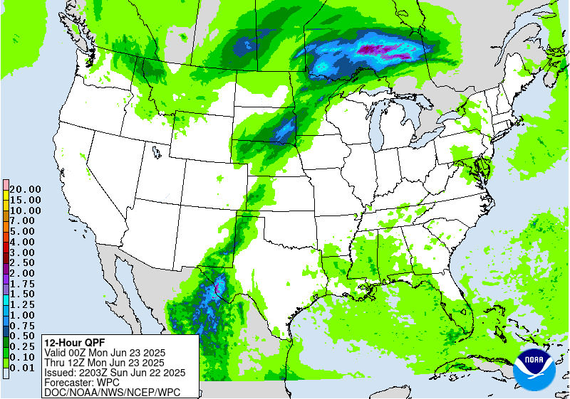
...THERE IS A SLIGHT RISK OF EXCESSIVE RAINFALL ACROSS PORTIONS OF
SOUTHEAST NEW MEXICO/SOUTHWEST TEXAS AND PARTS OF
PENNSYLVANIA/SOUTHERN NEW YORK...
16Z Excessive Rainfall Discussion...
New Mexico and Texas...
12Z upper air showed precipitable water values in excess of 2
inches continued to be drawn northward into West Texas...on par
with the 2 to 3 standardized anomaly precipitable water forecast
from the overnight numerical guidance. With the large scale forcing
largely in place...there were few changes needed here.
Northeast...
Introduced a Slight Risk in the area of instability ahead of
on-going convection building west/southwestward towards northeast
Pennsylvania and west-central New York. Based on cooling cloud top
temperatures and resumption of 1 inch per hour rainfall being
reported in Susquehanna county...combined with low 1-hour flash
flood guidance in the area...felt a Slight Risk area was warranted
despite some lingering questions as to how far west the activity
will develop,
Further details available in Mesoscale Precipitation Discussion
0492 from the WPC Metwatch desk.
The Dakotas/Nebraska to Minnesota...
Made a few adjustments to the northern portion of the Marginal Risk
area given convective behavior earlier this morning...while a
southward expansion into northern Nebraska was based largely on a
consistent signal for convective development during the afternoon
farther south and west than indicated by the 00Z/06Z numerical guidance.
This area of convection looks to be progressive...but locally
intense rates are possible given the precipitable water values
which exceed 1.75 inches by early evening.
Bann
...New Mexico and Texas...
Today is the beginning of what will be a multi-day period of
excessive rainfall potential over portions of west TX into NM. The
mid/upper level pattern features a near record to record ridge over
the eastern U.S. and a well-defined longwave trough over the west.
Southerly flow in between these features will supply ample
moisture to NM, with a connection all the way to the Caribbean Sea.
The better forcing from the western trough will generally hold of
until Monday and Tuesday (see the day 2 and 3 EROs), but today will
still have enough moisture and instability around for scattered
convective development. In fact PWs should already be getting
towards climatological max values for late June over portions of
southwest TX and immediate adjacent areas of NM. And while the
better forcing arrives Monday, do note broadly divergent flow at
250mb Sunday which could help sustain convection.
The greatest convective coverage is expected to be across portions
of southwest TX, where this is considered a higher end Slight
risk. Deep layer mean flow is weak, suggesting slow cell motions
today. Convection forming on/near terrain will slowly move off the
terrain, with outflows likely allowing for some cell merger
activity. Given this will be occurring within a very high PW
airmass, scattered areas of flash flooding appear likely. Both the
00z HREF and REFS indicate a high likelihood of rainfall locally
exceeding 3", with at least some potential of isolated amounts
over 5". A Marginal risk extends across much of eastern NM into
adjacent area of west TX, where storm coverage should be less...but
slow moving cells will still be capable of producing localized
flash flood concerns.
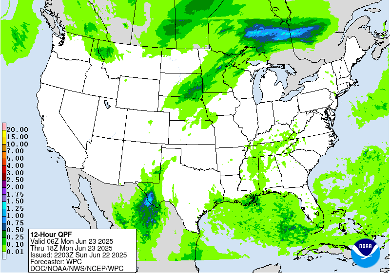
...Eastern Dakotas into Minnesota...
The setup looks favorable for another round of organized
convection this afternoon and evening across the region. Strong
shortwave energy ejecting into the northern Plains, a strengthening
axis of low level moisture transport, and upwards of 4000 j/kg of
MUCAPE will drive the convective threat. The combination of extreme
instability, PWs well over the 90th percentile for late June, and
a warm front focusing convection, all point to a heavy rainfall
threat. Main uncertainty is the longevity of higher rainfall rates
and the exact axis of convection. Cells will generally be moving
along quick enough to preclude much of a flash flood threat,
however some training along the warm front over far northern MN is
possible. Activity may actually get going this morning, with some
additional development by this afternoon. Also seeing a growing
signal for convective development by this evening over southeast SD
as convergence increases along the cold front. This activity
should move northeast along the axis of the front across MN
tonight. While this activity should be quick moving, heavy
rainfall rates could still pose an isolated flash flood risk.
...Northeast...
An area of organized convection is diving southeast across
portions of NY as of 08z this morning. The evolution of this
activity after 12z this morning remains a bit unclear, however
some backbuilding/training potential may persist on the
west/southwest flank of convection. While the motion of the
complex should continue off to the southeast with the deep layer
mean flow, upwind propagation vectors are off the southwest, a
favorable sign for backbuilding. There will be plenty of upstream
instability advecting in to sustain convection...however low level
convergence should be on the decrease after 12z, and continued
warm advection aloft will increase capping. Thus the degree of
maintenance beyond 12z remains a question...but seeing enough of a
threat for at least some backbuilding/training to justify a
Marginal risk in the new day 1 ERO. PWs are certainly high enough
to support at least a localized flash flood risk with any
convection that is able to train/backbuild this morning.
Chenard
Day 1 threat area: www.wpc.ncep.noaa.gov/qpf/94epoints.txt
Excessive Rainfall Discussion
NWS Weather Prediction Center College Park MD
423 PM EDT Sun Jun 22 2025
Day 2
Valid 12Z Mon Jun 23 2025 - 12Z Tue Jun 24 2025
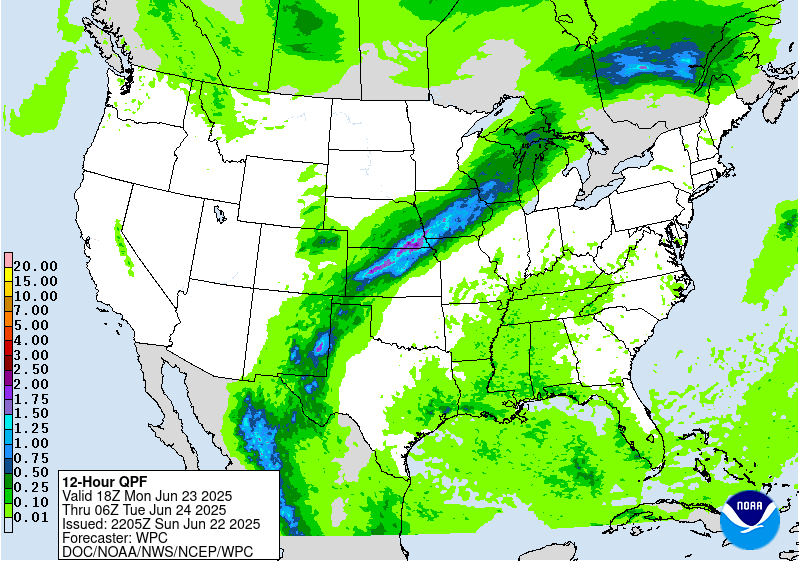
...THERE IS A SLIGHT RISK OF EXCESSIVE RAINFALL ACROSS PORTIONS OF
NEW MEXICO AND WEST TEXAS, AND FROM KANSAS INTO IOWA...
20Z Excessive Rainfall Discussion Update...
Few changes needed to the on-going ERO/ERD. The large-scale
forcing is pretty well established...with the uncertainty being
driven by placement of the smaller-scale details such as shortwave
troughs or minor perturbations. The probabilities associated with
the ERO still covers the big-picture well and accounts for the
uncertainty.
Bann
Previous Excessive Rainfall Discussion...
...Southwest...
The overall pattern over the Southwest described in the day 1
discussion will persist into the day 2 period. By Monday forcing,
moisture, and instability should all be on the increase across NM,
and thus expect convective coverage and flash flood risk to be on
the rise as well. The gradual approach of the west coast trough
will bring the right entrance region of the upper jet closer, and
continued moisture advection in between the trough and the east
coast ridge will push PWs well above the climatological 90th
percentile and towards late June record levels. Instability is a
bit of a question as cloud cover debris from Sundays activity could
play a role...however the model consensus is averaging 1000-2000
j/kg over much of eastern NM into far west TX. Not a ton of deep
layer flow, so convection forming on/near terrain should slowly
move off the terrain and allow for some cell merger activity. The
expected convective coverage should eventually erode instability
enough that activity trends down by overnight...but not before what
should be a more widespread scattered flash flood risk over
eastern NM and west TX where a Slight risk remains.
Far southeast NM into southwest TX looks to be a focus for more
organized slow moving convection, with the 00z RRFS, GEM Reg and
ECMWF all focusing higher totals over this area. In fact the RRFS
and Gem Reg indicate localized amounts over 3" are likely, with a
few spots over 5" possible. Another area of focus will be the
sensitive burn scar areas of the Sacramento Mountains. High res
guidance indicates a likelihood of strong convective development
over the terrain here Monday afternoon, with high rainfall rates
leading to what could be a locally significant flash flood risk.
...Central Plains to MS Valley...
A Slight risk remains from portions of central KS into southeast
NE and much of central and northern IA where convection along a
stationary front poses an isolated to scattered flash flood risk.
Model guidance indicates convective development along/near this
front Monday afternoon, with some persistence and/or upscale
development possible Monday evening as low level moisture
transport increases. Corfidi vectors over this area are divergent,
indicating a favorable environment for slow moving/backbuilding
convection near this front. PWs should be well over the 90th
percentile for late June along this front, as the same plume of
moisture over the Southwest will be in place here as well. Thus
any training of convection will pose a flash flood risk.
Maintenance of instability is probably the main question mark, as
the pool of forecast instability is not overly impressive and
neither is the magnitude of the low level jet...so the extent of
convective persistence into the overnight is a bit unclear. However
do note some upward trend in instability, so while this convection
should eventually erode the instability and weaken, we should
still be able to realize several hours of possible training
convection.
The highest probabilities of excessive rainfall are likely across
portions of north central KS into far southeast NE and far
southwest IA. It is here along the southwest flank of the
convection where we should have the strongest uptick in convergence
Monday evening, and also the better upstream instability pool. As
mentioned above, upwind propagation vectors are favorable for
backbuilding and training along this axis. Do consider this a
higher end Slight risk over this corridor, as the high PWs combined
with training convection supports a scattered flash flood risk. In
fact FFG exceedance may support MDT risk probs (40%), but given
dry antecedent soil conditions and the narrow nature of the
expected rainfall axis..will keep the risk at a higher end Slight
level for now.
Chenard
Day 2 threat area: www.wpc.ncep.noaa.gov/qpf/98epoints.txt
Excessive Rainfall Discussion
NWS Weather Prediction Center College Park MD
423 PM EDT Sun Jun 22 2025
Day 3
Valid 12Z Tue Jun 24 2025 - 12Z Wed Jun 25 2025
...THERE IS A MODERATE RISK OF EXCESSIVE RAINFALL OVER PORTIONS OF
CENTRAL NEW MEXICO...
20Z Excessive Rainfall Discussion Update...
Few changes needed to the on-going Day 3 ERO/ERD. This still
appears to be the bigger day in terms of areal coverage of
convection and associated rainfall/rainfall impacts...although
questions lingered about how much instability can generate if the
widespread/deep moisture results in increased cloud cover. The
placement of the storms and heavy rainfall on the periphery of a
broad upper high appears to still be favored.
Bann
...New Mexico...
Very similar setup as was described in the day 2 discussion
continues into Tuesday. The moisture axis will shift a bit farther
west by Tuesday, and with the upper trough getting closer large
scale forcing will be slightly stronger. So should be another day
of widespread convection over NM, with deterministic and ensemble
guidance suggesting this will be the day of highest areal averaged
rainfall. Flash flooding over this part of the country is heavily
driven by rainfall rates...and whenever you see a widespread heavy
QPF signal such as this you do wonder about the degree of
instability that will be present. We have seen before where these
more widespread rainfall days end up under performing flash flood
wise, as cloud cover limits instability and keeps rainfall rates
lower. So while that is something to keep in mind...all other
factors suggest Tuesday will be a day with scattered to numerous
instances of flash flooding over NM. It seems more likely that the
modest westward shift and increase in the moisture axis/forcing
will support areas or organized heavy rainfall rates.
Central NM seems most likely to see more numerous impacts and thus
a MDT risk was maintained across this area. Some of this MDT risk
area will also have likely seen heavy rainfall Monday, thus
hydrologic conditions over some of this area will likely be more
sensitive by Tuesday, adding to the flash flood risk. This MDT
risk area includes the sensitive burn scar areas of the Sacramento
Mountains. While much of NM will see a flash flood risk Tuesday,
the MDT risk area has the greatest risk of seeing more numerous
and higher end impacts. Some rainfall totals over 3" appear
probable, and would again not be surprised to see totals locally
exceed 5" where convection persists the longest.
...NE/SD/IA and vicinity...
A broad Slight risk was maintained across portions of NE/SD east
into IA, southern MN and southern WI. Some convection will likely
be ongoing across this area Tuesday morning, although would
generally expect this to be of a weakening nature. By afternoon we
should see additional development both the near the stationary
front and over the High Plains. Convective details by this lead
time become murky, and thus confidence on the details remain low.
The ingredients (high PWs, instability, stationary front) will
remain favorable for an area of excessive rainfall...and rainfall
on preceding days may make hydrologic conditions more sensitive
over portions of this area by this time. Ensemble probabilities and
recent runs of the AIFS highlight northeast NE into northern IA as
having the greatest heavy rainfall risk, and thus this portion of
the Slight risk is considered higher end. This is where the best
chance of scattered flash flooding seems to exist, especially if
this additional rain overlaps any areas of heavy rainfall from
Monday.
Chenard
Day 3 threat area: www.wpc.ncep.noaa.gov/qpf/99epoints.txt
NWS Weather Prediction Center College Park MD
258 AM EDT Sun Jun 22 2025
On Wednesday, the upper trough in the Interior West will be
gradually weakening, lessening upper jet right entrance region
support and slightly lessening moisture anomalies in the southern
Rockies/High Plains compared to what's now the short range period.
However, some heavy rain could still be a concern centered around
New Mexico, especially considering the wet antecedent conditions by
then. A Slight Risk is delineated in the Sacramento Mountains and
vicinity for the Day 4/Wednesday ERO, where orographic support
could enhance rainfall totals and where burn scars and steep
terrain make the area sensitive to heavy rain. Rain amounts should
continue to gradually decrease there into later week. Will show a
Marginal Risk on Day 5/Thursday for southern portions of New Mexico
including the Sacramento Mountains for another potential round of
moderate to locally heavy rain.
The plume of subtropical/tropical moisture will arc northeastward
into the north-central Plains and Upper Midwest/Corn Belt where the
additional lift around the frontal boundary and potential training
will favor areas of heavier rainfall and some flash flooding
potential. For the Day 4/Wednesday ERO, continue to show a Slight
Risk (with embedded probabilities on the higher end of the Slight
range) for these areas. The Slight generally covers some model
spread from an eastern Nebraska focus to areas farther northeast.
The details in the heavy rainfall placement remain uncertain south
due to the sensitivity to day-to-day rainfall patterns and
mesoscale boundaries. A weak surface low embedded along the front
may track somewhat east by Thursday, pushing the heaviest rain
totals across much of Wisconsin and possibly the U.P. of Michigan.
Thus for the initial Day 5/Thursday ERO, will show a Slight Risk
there, given potential for 2 to 4 inches to accumulate despite
continued spread in the exact positioning. For both Wednesday and
Thursday, some convection with locally heavy rain could traverse
the northern side of the ridge farther east into New York State and
the northern Mid-Atlantic, so will show Marginal Risks there. The
Northeast may see increasing rain amounts by Friday, while another
round of rain is possible in the north-central U.S. late week as
well.
Farther south, there is some uncertainty with how much convection
may occur under the upper ridge across the Gulf Coast and
southeastern U.S. as surface-based instability likely battles with
subsidence aloft. In general, scattered thunderstorms may increase
in coverage as the week progresses as the upper high gradually
weakens.
The strong upper high/ridge stretching across the south-central to
eastern U.S. will allow for well above average temperatures that
could approach or exceed daily records at a few dozen locations
through Wednesday, with more widespread coverage of record warm
morning lows if those numbers hold through the calendar day. This
translates into highs well into the 90s into the low 100s, with
heat indices to near 110F as dew points will be in the 60s to
low/mid-70s. Overnight lows will only drop into the low/mid 70s for
many areas, and even may stay around 80-83F in the urban centers
like Washington, D.C., Baltimore, Philadelphia, and New York City.
This will bring little relief from the heat and exacerbate
potential impacts. Thus, HeatRisk values will be Major to Extreme
for portions of the Midwest and Ohio Valley to Eastern states --
levels 3 and 4 on a scale from 1 to 4 (4 being Extreme). This
indicates an intensity and duration of heat that is extremely
dangerous to anyone without adequate cooling or hydration. Extreme
heat is the number 1 weather-related killer -- please take
precautions if you are outside during the hottest part of the day
and seek cooling if you are without adequate means. Temperatures
will remain above average, though a few degrees lower and with
fewer records possible, across much of the Ohio Valley/Mid-
Atlantic/Southeast into the latter part of next week. But the
Northeast should see moderating temperatures after a cold frontal
passage. Meanwhile, temperatures (particularly highs) are forecast
to be below average by a few degrees in the High Plains into
midweek, but the West should gradually warm to a bit above average
as the week progresses.
Tate


» Interactive Winter Weather Map (Day 4-7)
» Winter Storm Severity Index
» Experimental Probabilistic Precipitation Portal
+ Forecast Discussion (Day 1-3)
Probabilistic Heavy Snow and Icing Discussion
NWS Weather Prediction Center College Park MD
214 PM EDT Wed May 7 2025
Valid 00Z Thu May 08 2025 - 00Z Sun May 11 2025
...Colorado...
Day 1...
Lingering vorticity on the western side of the departing upper low
will still trigger some light snow over the San Juans this evening
before tapering off tonight/early Thursday. WPC probabilities for
at least an additional 4 inches of snow after 00Z are low (10-40%)
above 11,000ft.
For days 2-3, the probability of at least 4 inches of snow is less
than 10%.
The probability of significant freezing rain across the CONUS is
less than 10%.
Note - this is the last regularly scheduled discussion (QPFHSD)
for the 2024-2025 winter season. Unless a significant winter
weather threat emerges, this discussion will next be updated on or
about September 25, 2025.
Fracasso


NWS Weather Prediction Center College Park MD
243 PM EDT Sun Jun 22 2025
Valid 12Z Wed Jun 25 2025 - 12Z Sun Jun 29 2025
...Record heat gradually lessens but dangerous heat continues for
the Ohio/Tennessee Valleys and Mid-Atlantic/Southeast mid to late
week...
...Heavy rain and flash flooding concerns continue for the north-
central Plains/Upper Midwest Wednesday and Thursday, and lingering
in New Mexico Wednesday...
...Overview...
As the medium range period begins Wednesday, a significant and
extremely dangerous heat wave will be ongoing across the Midwest,
Ohio Valley, and eastern U.S. as a notably strong upper high is
centered from the Ohio/Tennessee Valleys into the Mid-Atlantic. The
extreme, record-breaking heat should moderate slowly midweek and
beyond, but temperatures will remain quite hot across those areas,
and the long duration of the heat wave could cause exacerbated
impacts. Meanwhile strong southerly inflow with deep tropical
moisture will set up between the upper high and an initial mean
trough with embedded shortwaves in the West. Moisture will
initially reach New Mexico and lead to additional heavy rain there
(extending from the short range into the medium range), with the
moisture then reaching around the upper ridge (in a "ring of fire"
setup). This should interact with a wavy frontal boundary and
promote another area of potentially heavy rain and flash flooding
over the north-central Plains, Corn Belt/Midwest, and Great
Lakes/Northeast region.
...Guidance/Predictability Assessment...
The large scale pattern remains in excellent agreement for
midweek, as models for several days have shown a 594+ dm upper
ridge lasting through Wednesday, and weakening and flattening after
that. Meanwhile farther west, troughing across the Great Basin and
vicinity will also weaken as the week progresses. This, combined
with a wave train of northern stream shortwaves, will trend the 500
mb flow pattern toward more zonal and less amplified flow for the
latter half of the week. The slight differences in speed and
amplitude of multiple shortwaves streaming from the West to the
Upper Midwest introduces a bit more uncertainty for the mid to late
medium range period, but nothing out of the ordinary at that time
range. Somewhat broader scale troughing moving into the Northwest
late week and progressing eastward into the weekend shows some
timing and amplitude differences. The 06Z GFS was a bit offset from
the larger cluster of solutions around the 00Z ECMWF with
shortwaves out of the northeastern Pacific, so it was excluded from
the blend by next weekend.
The WPC forecast for mass fields was based on a general multi-
model blend early in the period before sunsetting the GFS in favor
of the ensemble means and continuity. The NBM was sufficient for
most sensible weather grids. For QPF, main challenge was with the
placement and downstream extension of heavier rainfall from NE/IA
up and over the ridge into the Great Lakes and possible
Northeast/Mid-Atlantic. This was encapsulated within the Excessive
Rainfall Outlooks for days 4-5.
...Weather/Hazards Highlights...
On Wednesday, the upper trough in the Interior West will be
gradually weakening, lessening upper jet right entrance region
support and slightly lessening moisture anomalies in the southern
Rockies/High Plains compared to what's now the short range period.
However, some heavy rain could still be a concern centered around
New Mexico, especially considering the wet antecedent conditions by
then. A Slight Risk is delineated in the Sacramento Mountains and
vicinity for the Day 4/Wednesday ERO, where orographic support
could enhance rainfall totals and where burn scars and steep
terrain make the area sensitive to heavy rain. Rain amounts should
continue to gradually decrease there into later week. Maintained a
Marginal Risk on Day 5/Thursday for southern portions of New Mexico
including the Sacramento Mountains for another potential round of
moderate to locally heavy rain.
The plume of subtropical/tropical moisture will arc northeastward
into the north-central Plains and Upper Midwest/Corn Belt where the
additional lift around the frontal boundary and potential training
will favor areas of heavier rainfall and some flash flooding
potential. For the Day 4/Wednesday ERO, continue to show a Slight
Risk (with embedded probabilities on the higher end of the Slight
range) for these areas. The Slight generally covers some model
spread from an eastern Nebraska/northwestern Iowa focus to areas
farther northeast (southern MN to northern/central WI). The details
in the heavy rainfall placement remain uncertain due to the
sensitivity of day-to-day rainfall patterns and mesoscale
boundaries. A weak surface low embedded along the front may track
somewhat east by Thursday, pushing the heaviest rain totals across
much of Wisconsin and possibly the U.P. of Michigan. Thus for the
initial Day 5/Thursday ERO, will show a Slight Risk there, given
potential for 2 to 4 inches to accumulate despite continued spread
in the exact positioning. Nudged the focus area southward a bit due
to a shift southward with the frontal placement. For both
Wednesday and Thursday, some convection with locally heavy rain
could traverse the northern side of the ridge farther east into New
York State and the northern Mid- Atlantic, and have captured these
areas within the Marginal Risk as well. The Northeast may see
increasing rain amounts by Friday, while another round of rain is
possible in the north- central U.S. late week as well.
Farther south, there is some uncertainty with how much convection
may occur under the upper ridge across the Gulf Coast and
southeastern U.S. as surface-based instability likely battles with
subsidence aloft. In general, scattered thunderstorms may increase
in coverage as the week progresses as the upper high gradually
weakens. For now, will leave this area out of any Marginal Risk in
the ERO.
The strong upper high/ridge stretching across the south-central to
eastern U.S. will allow for well above average temperatures that
could approach or exceed daily records at a few dozen locations
early in the week (short range) but fewer by Wednesday. Record warm
morning lows are possible if those numbers hold through the
calendar day. This translates into highs well into the 90s into the
low 100s, with heat indices to near 110F as dew points will be in
the 60s to low/mid-70s. Overnight lows will only drop into the
low/mid 70s for many areas, and even may stay around 80-83F in the
urban centers like Washington, D.C., Baltimore, Philadelphia, and
New York City Wednesday morning. This will bring little relief from
the heat and exacerbate potential impacts. Thus, HeatRisk values
will be Major to Extreme for portions of the Midwest and Ohio
Valley to Eastern states -- levels 3 and 4 on a scale from 1 to 4
(4 being Extreme). This indicates an intensity and duration of heat
that is extremely dangerous to anyone without adequate cooling or
hydration. Extreme heat is the number 1 weather-related killer --
please take precautions if you are outside during the hottest part
of the day and seek cooling if you are without adequate means.
Temperatures will remain above average, though a few degrees lower
and with fewer records possible, across much of the Ohio
Valley/Mid- Atlantic/Southeast into the latter part of next week.
But the Northeast should see moderating temperatures after a cold
frontal passage. Meanwhile, temperatures (particularly highs) are
forecast to be below average by a few degrees in the High Plains
into midweek, but the West should gradually warm to a bit above
average as the week progresses.
Fracasso/Tate
Additional 3-7 Day Hazard information can be found on the WPC
medium range hazards outlook chart at:
https://www.wpc.ncep.noaa.gov/threats/threats.php
WPC medium range 500mb heights, surface systems, weather grids,
quantitative precipitation forecast (QPF), excessive rainfall
outlook (ERO), winter weather outlook (WWO) probabilities, heat
indices, and Key Messages can be accessed from:
https://www.wpc.ncep.noaa.gov/medr/5dayfcst500_wbg.gif
https://www.wpc.ncep.noaa.gov/medr/5dayfcst_wbg_conus.gif
https://www.wpc.ncep.noaa.gov/5km_grids/5km_gridsbody.html
https://www.wpc.ncep.noaa.gov/qpf/day4-7.shtml
https://www.wpc.ncep.noaa.gov/#page=ero
https://www.wpc.ncep.noaa.gov/wwd/pwpf_d47/pwpf_medr.php?day=4
https://www.wpc.ncep.noaa.gov/heat_index.shtml
https://www.wpc.ncep.noaa.gov/#page=ovw

Displays flood and flash flood reports as well as intense rainfall observations for user-selectable time ranges and customizable geographic regions. Includes ability to download reports and associated metadata in csv format.

Interface for specialized WPC Excessive Rainfall Outlook Maps for NWS County Warning Areas and States.

Custom plots of Local Storm Reports across the Contiguous United States. Reports include rain, snow, ice, and severe weather, as well as other significant information from storm spotters.

Displays the climatological significance of precipitation forecast by WPC. The climatological significance is represented by Average Recurrence Intervals (ARIs) of precipitation estimates from NOAA Atlas-14 and Atlas2.

An interactive situational awareness table that displays anomalies, percentiles, and return intervals from the GEFS, NAEFS, and ECMWF Ensembles (login required to view ECMWF data).
*Please note that there is currently an issue where only users on a NOAA network can access this page. We are actively working to resolve this problem.

Interactive display of where temperatures could approach or exceed records within the contiguous U.S. (based on NDFD temperature forecasts)

Displays Days 1-7 NDFD maximum and minimum temperatures, along with their respective departures from climatology.
Contains 4 different tools to track precipitation objects (heavy rain and snowfall) from short-range high-resolution deterministic and ensemble guidance.

Displays forecast information and its climatological context to quickly alert a forecaster when a record or neear-record breaking event is possible. This tool is available for both CONUS and Alaska.

Displays 0-72 hour cyclone forecast positions from global ensemble and deterministic model guidance.

Change in weather parameters (temperature, dewpoint, surface pressure, etc) over the last 1/3/6/24 hours. Data is provided from the Real-Time Mesoscale Analysis (RTMA) or the Rapid Refresh (RAP).

The experimental National Weather Service (NWS) HeatRisk is a color-numeric-based index that provides a forecast of the potential level of risk for heat-related impacts to occur over a 24-hour period, with forecasts available out through 7 days.


Analog guidance that uses an objective approach to find historical events that are similar to the upcoming forecast.

Nationally consistent and skillful suite of calibrated forecast guidance based on a blend of both NWS and non-NWS numerical weather prediction model data and post-processed model guidance.


