Short Range Forecast Discussion
NWS Weather Prediction Center College Park MD
401 PM EDT Sun Jun 22 2025
Valid 00Z Mon Jun 23 2025 - 00Z Wed Jun 25 2025
...There are Extreme Heat Warnings and Heat Advisories across much of the
eastern third of the country...
...There is a Moderate Risk of excessive rainfall over parts of the
Southern Rockies on Tuesday...
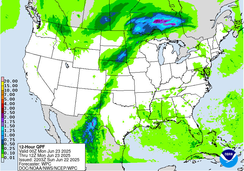
...There is a Slight Risk of excessive rainfall over parts of southwestern
Texas, southeastern New Mexico, and northern Mid-Atlantic on Sunday, as
well as Upper/Middle Mississippi Valley/Central Plains and Southern
Rockies/Southern High Plains on Monday...
...There is a Slight Risk of severe thunderstorms over parts of the
Northern Plains, and Central/Southern High Plains/Upper Mississippi Valley
and northern Mid-Atlantic on Sunday as well as Upper Great Lakes,
Upper/Middle Mississippi Valley, and Central Plains on Monday...
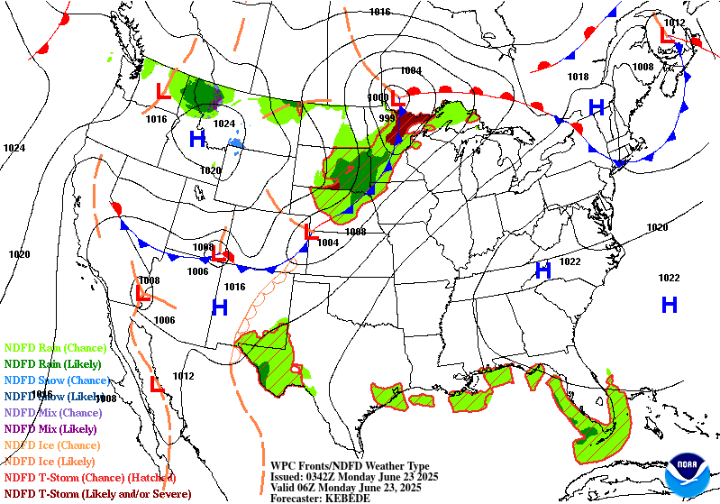
There is an upper-level high over the Ohio Valley that will be
quasi-stationary through Tuesday that will contribute to Extreme Heat
Warnings and Heat Advisories across much of the eastern third of the
country. Extreme heat shifts east over the Midwest and Great Lakes on
Sunday and expands to the East Coast by Monday. Light winds, sunny days,
record-high daytime, and high overnight temperatures will create a lack of
overnight cooling, significantly increasing the danger. This heat level
can be dangerous to anyone without effective cooling and/or adequate
hydration, especially those engaging in lengthy outdoor activities.
Heat-related illnesses increase significantly during extreme heat. Wear
lightweight and loose-fitting clothing. Take action when you see symptoms
of heat exhaustion and heat stroke.
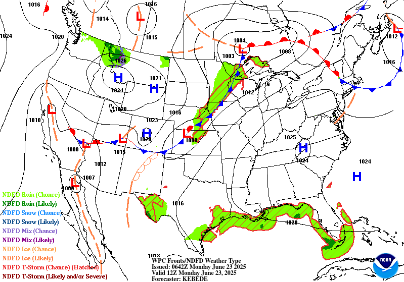
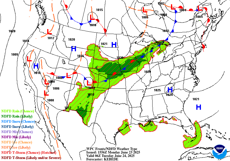
In addition, a front extending from the Upper Great Lakes to the
Northern/Central Plains and Central Rockies and then into the Great Basin
will move slowly eastward to the Lower Great Lakes, the Middle Mississippi
Valley, and Central Plains by Tuesday evening. Moisture pooling along the
boundary and east of the dryline will produce showers and severe
thunderstorms from the Northern Plains and Central/Southern High
Plains/Upper Mississippi Valley. Therefore, the SPC has issued a Slight
Risk (level 2/5) of severe thunderstorms over parts of the Northern Plains
and Central/Southern High Plains/Upper Mississippi Valley through Monday
morning. The hazards associated with these thunderstorms are frequent
lightning, severe thunderstorm wind gusts, hail, and a few tornadoes.
Moreover, there will be an increased threat of severe thunderstorm wind
gusts of 65 knots or greater and hail two inches or greater over parts of
the Upper Mississippi Valley.
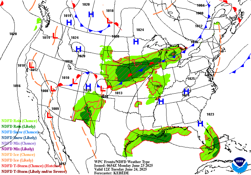
Furthermore, moisture will stream northwestward over Texas and interact
with upper-level energy to produce showers and thunderstorms, creating
heavy rain over parts of southwestern Texas and southeastern New Mexico.
Therefore, through Monday morning, the WPC has issued a Slight Risk (level
2/4) of excessive rainfall over parts of southwestern Texas and
southeastern New Mexico. The associated heavy rain will create mainly
localized areas of flash flooding, with urban areas, roads, small streams,
and low-lying areas the most vulnerable.
Moreover, upper-level energy over the Northeast and moisture rounding the
periphery of the upper-level ridge will produce showers and severe
thunderstorms with heavy rain over parts of the northern Mid-Atlantic.
Therefore, the WPC has issued a Slight Risk (level 2/4) of excessive
rainfall over parts of the northern Mid-Atlantic through Monday morning.
The associated heavy rain will create mainly localized areas of flash
flooding, with urban areas, roads, small streams, and low-lying areas the
most vulnerable.
Additionally, the SPC has issued a Slight Risk (level 2/5) of severe
thunderstorms over parts of the northern Mid-Atlantic through Monday
morning. The hazards associated with these thunderstorms are frequent
lightning, severe thunderstorm wind gusts, hail, and a few tornadoes.
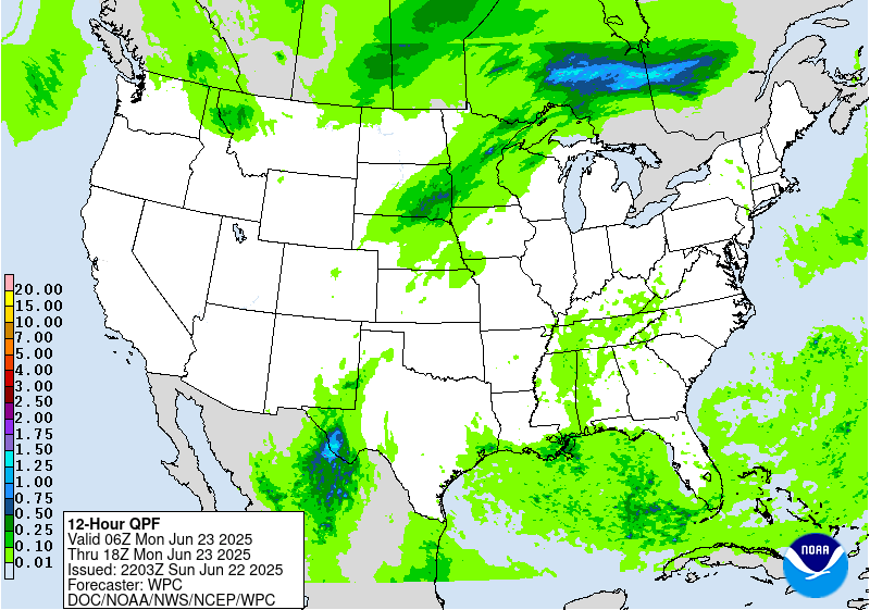
Moreover, on Sunday, moisture and upper-level impulses will trigger
showers and thunderstorms over parts of the Southern Ohio/Tennessee
Valleys and the Lower Mississippi Valley/Southeast.
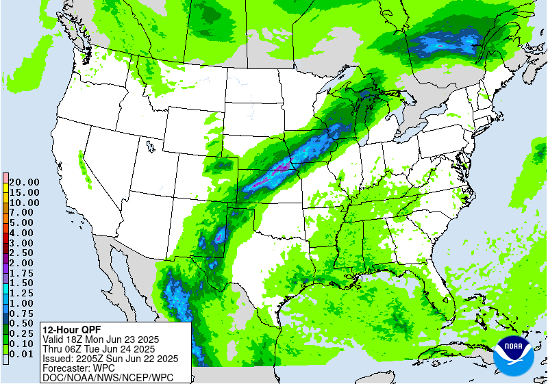
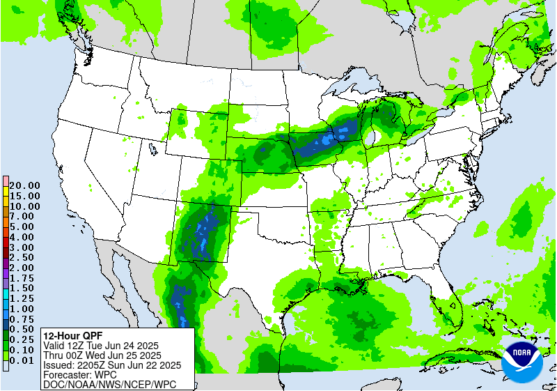
On Monday, moisture will continue to flow along the front over the Upper
Great Lakes, Upper/Middle Mississippi Valley, and Central Plains,
producing showers and severe thunderstorms in the areas. Therefore, the
SPC has issued a Slight Risk (level 2/5) of severe thunderstorms over
parts of the Upper Great Lake/Upper/Middle Mississippi Valley and Central
Plains from Monday through Tuesday morning. The hazards associated with
these thunderstorms are frequent lightning, severe thunderstorm wind
gusts, hail, and a few tornadoes.
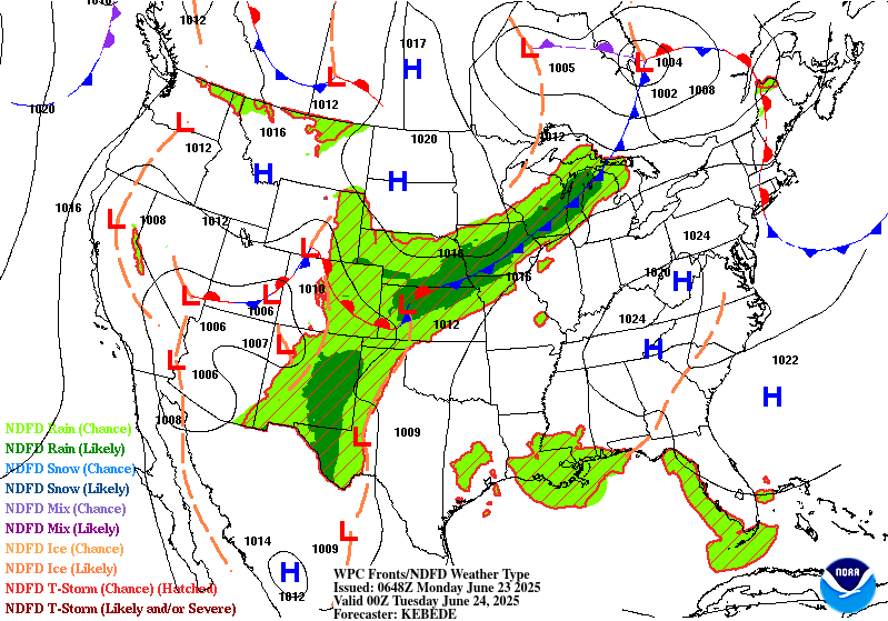
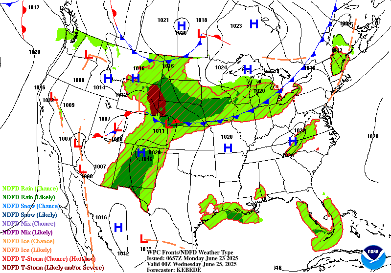
Furthermore, the showers and thunderstorms will produce heavy rain
covering parts of the Upper/Middle Mississippi Valley and Central Plains.
Therefore, the WPC has issued a Slight Risk (level 2/4) of excessive
rainfall over parts of the Upper/Middle Mississippi Valley and Central
Plains from Monday through Tuesday morning. The associated heavy rain
will create mainly localized areas of flash flooding, with urban areas,
roads, small streams, and low-lying areas the most vulnerable.
A second area of heavy rain will develop over parts of the Southern
Rockies and Southern High Plains. Therefore, the WPC has issued a Slight
Risk (level 2/4) of excessive rainfall over parts of the Southern Rockies
and Southern High Plains from Monday through Tuesday morning. The
associated heavy rain will create mainly localized areas of flash
flooding, with urban areas, roads, small streams, and low-lying areas the
most vulnerable.
Moisture and daytime heating will also produce showers and thunderstorms
on Monday over most of the eastern third of the country.
Elsewhere, on Sunday, upper-level energy over the Northern Rockies will
help produce showers and thunderstorms over parts of the Northern
Intermountain Region and Northern Rockies, which will taper off by Monday.
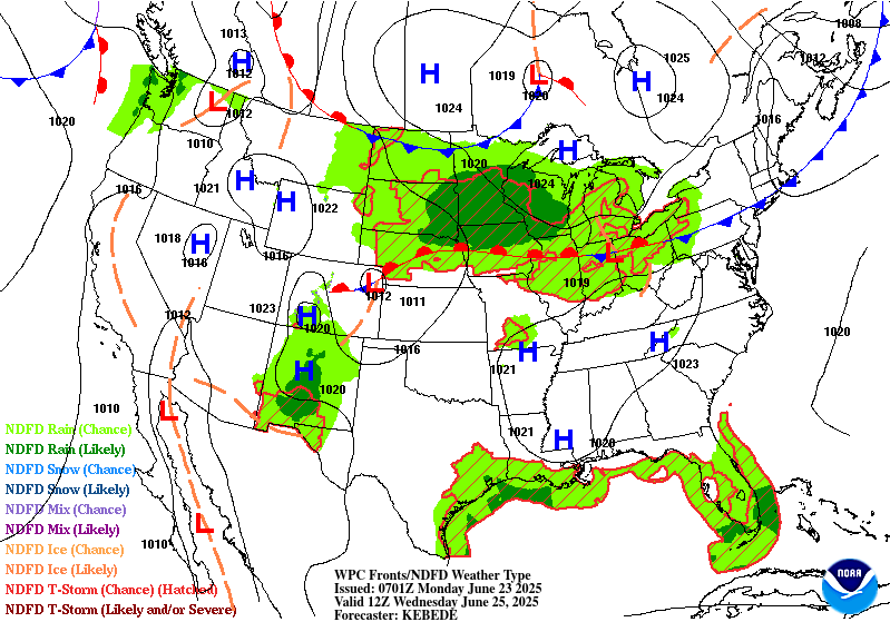
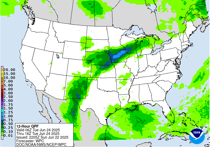
On Tuesday, moisture will continue to stream over the Southern
Rockies/Southern High Plains into the Central Plains/Middle Mississippi
Valley. The moisture and energy will produce showers, thunderstorms, and
heavy rain over the Southern Rockies. Therefore, the WPC has issued a
Moderate Risk (level 3/4) of excessive rainfall over parts of the Southern
Rockies on Tuesday. Numerous flash flooding events are possible. In
addition, many streams may flood, potentially affecting larger rivers.
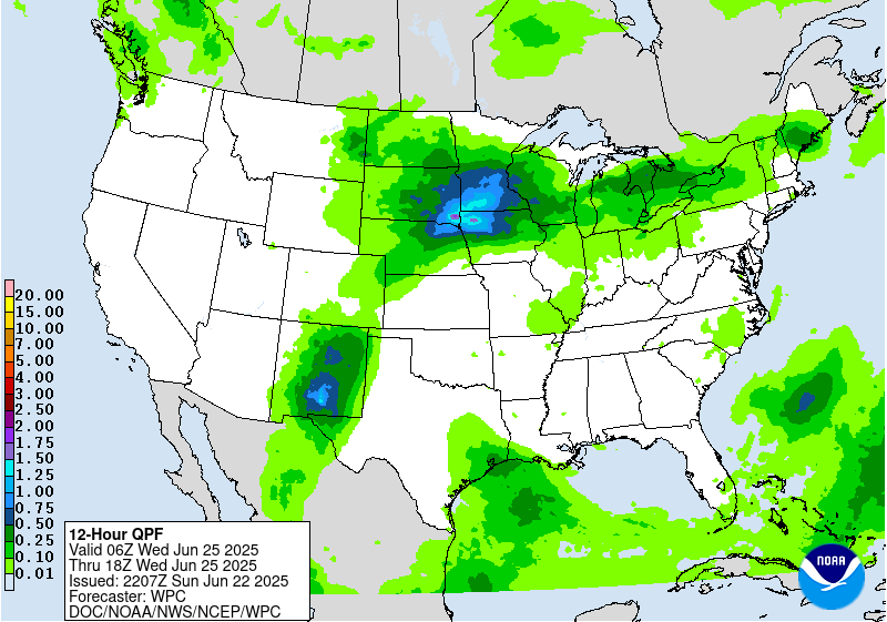
Further, heavy rain will develop river parts of the Northern/Central
Plains and Upper /Middle Mississippi Valley on Tuesday. Therefore, the WPC
has issued a Slight Risk (level 2/4) of excessive rainfall over parts of
the Northern/Central Plains and Upper /Middle Mississippi Valley on
Tuesday. The associated heavy rain will create mainly localized areas of
flash flooding, with urban areas, roads, small streams, and low-lying
areas the most vulnerable.
In addition, showers and severe thunderstorms will develop over parts of
the Central High Plains. Therefore, the SPC has issued a Slight Risk
(level 2/5) of severe thunderstorms over parts of the Central High Plains
on Tuesday. The hazards associated with these thunderstorms are frequent
lightning, severe thunderstorm wind gusts, hail, and a few tornadoes.
Ziegenfelder
Graphics available at
https://www.wpc.ncep.noaa.gov/basicwx/basicwx_ndfd.php


