Excessive Rainfall Discussion
NWS Weather Prediction Center College Park MD
857 PM EDT Wed Jun 25 2025
Day 1
Valid 01Z Thu Jun 26 2025 - 12Z Thu Jun 26 2025
...THERE IS A SLIGHT RISK OF EXCESSIVE RAINFALL OVER PORTIONS OF
NEW MEXICO, CENTRAL PLAINS, AND MIDWEST...
...01Z Update...
With much of the Marginal Risk areas largely driven by diurnal
heating, the areas were shrunken down noticeably in the East and
in on the northern flank of the Marginal Risk area in the Upper
Midwest. The Slight Risk in the Upper Midwest was also trimmed back
on the northern flank as the best instability and forcing now lies
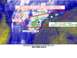
from central Nebraska on east across the Missouri River and into
eastern Iowa. The Slight Risk there was adjusted to account for new
18Z HREF probabilistic guidance, but the meteorological rationale
for supporting the Slight Risk into tonight remains on track. ECMWF
SATs for 06Z tonight show a ribbon of >99.5 climatological
percentile PWATs from the central NE/KS border that extends east
through southern MN and central WI. The Slight Risk area is also
likely to have as much as 1,000 J/kg of MUCAPE at its disposal
as a steadfast 30-40kt LLJ runs parallel to a nearby surface
trough. The Slight Risk was maintained in southern NM and far
western TX given the lingering thunderstorm activity will last a
little longer than the storms in the East. Lingering instability
and anomalous moisture may keep storms deeper into the evening
hours as a result.
---Previous Discussion---
...16Z Update...
Only minor areal modifications were made to better focus the
inherited Slight Risk areas based on the latest 12Z guidance, with
the prior forecast remaining ontrack overall. This included a
westward shift of the Slight Risk over the Upper Midwest where the
greater risk looks to be closer to the Upper Mississippi Valley
rather than eastward towards the Great Lakes. Still expect that the
higher-end threat within the Slight Risk exists in a corridor from
the central Missouri Valley northeastward towards the greater
Minneapolis area, where the greatest chance for rainfall totals of
3-4", locally 5-6", exists and may lead to more widespread
instances of flash flooding. For New Mexico/west Texas, the latest
guidance indicates that the more focused, higher-end threat within
the Slight Risk has concentrated southward over south-central New
Mexico (including the Sacramento Mountains and Ruidoso burn scar)
as well as western Texas from greater El Paso eastward through the
Guadalupe mountains. This covers the region with the greatest
potential for rainfall totals upwards of 2", locally 3".
Putnam
---Overnight Discussion---
...New Mexico...
Despite a bit less areal coverage anticipated for convection
across New Mexico for Wednesday, scattered thunderstorms will still
cause problems after daytime initiation as ample heating during
the prime destabilization window (16-21z) will yield another threat
of heavy rainfall across the terrain and adjacent valleys across
NM. Main jet to the north will lift out of the area allowing for
less of a large scale ascent pattern that could maximize any
convective pattern over the region. Remnant elevated moisture
(PWATs) running between 1-2 standard deviations above normal on
the western flank of our ridge will still be located across the
state leaving an environment capable of heavy rainfall in any
convective cores that develop. Impacts the previous period were
felt over a large portion of the state leading to generally lower
FFG's bisecting much of the area expected to see a chance for
convection today. Latest HREF neighborhood probs for >3" are
running pretty high (50-70%) across places like El Paso and points
north within part of the Sacramento's, an area we have highlighted
the past several days. Modest probs (20-40%) for >3" extend all
the way up into the Sangre de Cristos with some smaller relative
mins mixed into the areal coverage. This is more a testament to the
valley/terrain components littered over the state, so not all areas
will see impactful rainfall with this convective evolution.
The signal is sufficient enough to warrant a broad SLGT risk
within the state extending down through far West TX given the
current CAMs interpretation of scattered heavy convection likely to
impact portions of El Paso and Hudspeth counties through part of
the period. Some strong cells could even develop across the NM
Caprock as inferred by a few hi-res deterministic, likely due to
the favorable instability tongue positioned over the eastern side
of the state behind a vacating surface trough. High end SLGT risk
is favored for areas across Southern NM up through Central portion
of the state with the favored areas likely including the
Sacramento's, Sangre de Cristos, and areas within and surrounding
El Paso.
...Central Plains to Midwest...
Convective pattern across the Plains and Midwest at the end of the
D1 will translate northward into the Upper Mississippi Valley with
organized convection over NE/IA and SD/MN converging along the
propagating warm front leading to a swath of heavy rainfall across
much of the Southern 1/3rd of MN into Western WI. Beginning to see
the CAMs come into better agreement on the anticipated convective
evolution with a dual QPF maxima most likely situated over the area
between Aberdeen, SD to Minneapolis with a consensus on the
heaviest precip along and south of I-94 in MN with a bullseye
generally overhead or very close to Minneapolis proper. The second
maxima is positioned across Northeast NE into Northern IA to the
southern reaches of the MN border where a multi-round convective
impact forecast is being depicted in guidance as the initial round
in the morning will give way to a short break before redevelopment
occurs back along the frontal positioning bisecting the area. A
strong IVT pulse currently aligned from KS up through Eastern NE
has helped push PWATs closer to the 99th percentile around Omaha
this evening with the 00z RAOB out of KOAX depicting a PWAT of
1.94", putting this just below the daily climatological max for the
day (25/00z) and well above the 90th percentile for not just the
period, but even for the sites general historical record. This same
airmass is what's progged to advect northeast into MN and Western
WI by the time we reach tomorrow afternoon, a signal that would
prime any convective impacts to likely provide some prolific heavy
rain cores in stronger cells impacting the region. With the proxy
of the front and the environment in place, there's ample evidence
that some areas across the Midwest will see between 3-6" with the
5-6" range within reason as inferred by modest >5" neighborhood
probs (20-35%) in the latest HREF output. This same signal is
situated over the two defined maxima in guidance with the >3"
signal between 50-80% for both areas.
Considering all of the above factors and relatively good agreement
within the 00z guidance this evening, the previous SLGT risk was
maintained and leans towards a higher end risk with some prospects
of a targeted upgrade in any of those outlined forecast maxima by
the next update. Widespread significant impacts are not
anticipated at this time, but locally considerable flash flooding
is plausible in the setup. SLGT risk extends into the Western Great
Lakes on the eastern flank and down into Southern NE on the
southwest flank of the risk with potentially for widely scattered
flash flood prospects as convection impacts both areas during the
period.
...Mid Atlantic...
The northern fringe of our powerful ridge centered over the Ohio
Valley and Mid Atlantic will begin breaking down through the course
of Wednesday with an increase in PWATs likely to advect over the
area as moisture finally, "rounds the bend" over the Great Lakes
and pushes into the Northeast CONUS. Mean flow will shift more
northwesterly by the time we reach the afternoon hrs with a
significantly buoyant environment in place and generally less
capping as our ridge weakens. A few small mid-level perturbations
analyzed over the Great Lakes currently will sweep southeastward
into PA by morning and eventually cross over the region by peak
diurnal maximum. The combination of a very buoyant environment
with focused ascent will lead to scattered thunderstorm development
across much of PA, Northern WV, and into the Central Mid Atlantic
domain with sights on Southern NJ/MD/Northern VA. MUCAPE between
2500-4000 J/kg across the Central Mid Atlantic and a maxima near
5000 J/kg out in the Central Appalachians will be plentiful to help
boost convective magnitude as cells develop and mature on their
way to the southeast. Cell motion will thankfully be somewhat
progressive leading to a low prospect for training. However, PWATs
running ~2 deviations above normal (1.8-2.1") across much of the
region will certainly benefit heavy rain prospects with hourly
rates likely to settle between 1-2"/hr in any given location with
some stronger cores possibly hitting upwards of 2-3"/hr on average
with higher intra-hour rates. A MRGL risk remains in effect for
much of the Mid Atlantic with the northern periphery of the risk
area as far north as NY state with the southern edge down into
Central VA.
...Southeast...
A migrating TUTT cell off the coast of FL will continue to
propagate westward and provide favorable ascent within the proxy of
the Southeastern CONUS. Unstable airmass and large scale ascent
will aid in scattered thunderstorms developing all across the South
with the highest threat of heavy rainfall centered over Southern NC
down through Central SC into Southern GA where instability (>3000
J/kg of SBCAPE) is forecast to be highest. Heavy rainfall of
2-3"/hr is anticipated in some of the stronger convective cores
leading to isolated flash flood prospects in any urbanized
settings. Given the more focused ascent pattern provided by the
advancing TUTT, the threat sneaks into the lower end of the MRGL
risk threshold, so a broad MRGL was positioned over much of the
Southeast to cover the threat.
Kleebauer
Day 1 threat area:
www.wpc.ncep.noaa.gov/qpf/94epoints.txt
Excessive Rainfall Discussion
NWS Weather Prediction Center College Park MD
449 AM EDT Thu Jun 26 2025
Day 1
Valid 12Z Thu Jun 26 2025 - 12Z Fri Jun 27 2025
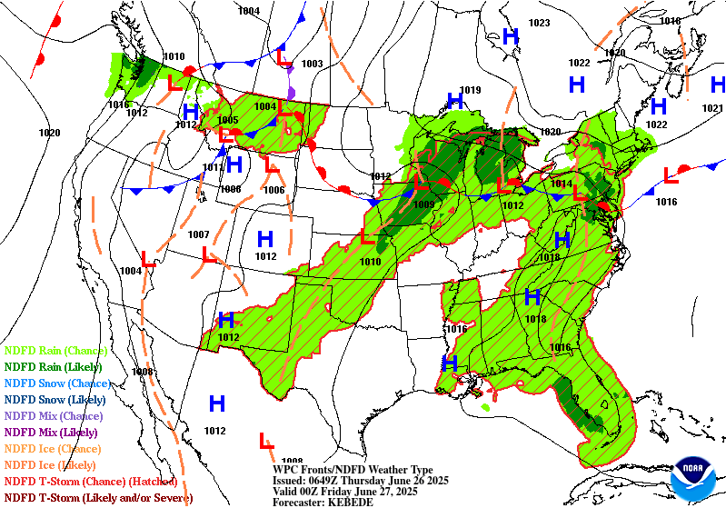
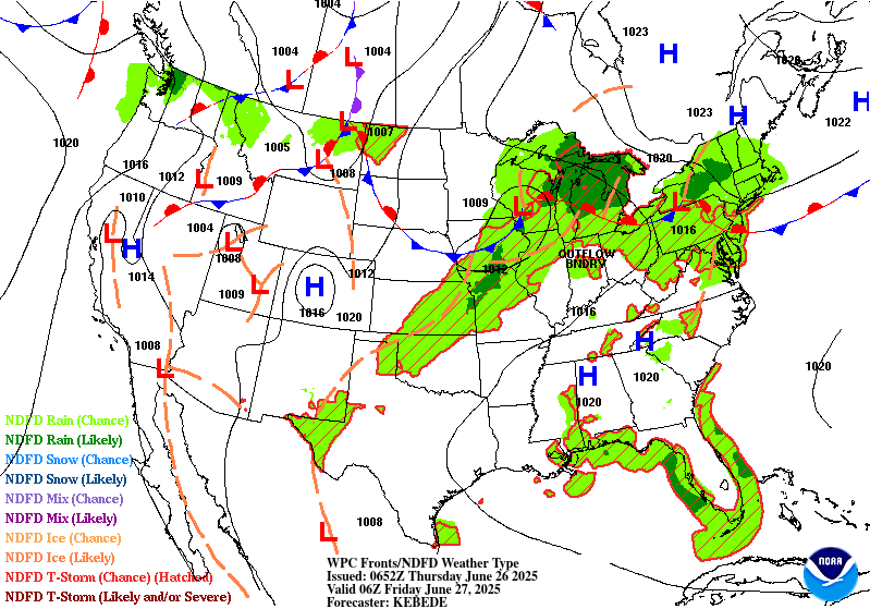
...THERE IS A SLIGHT RISK OF EXCESSIVE RAINFALL ACROSS PARTS OF
THE CENTRAL PLAINS, UPPER MIDWEST, AND UPPER GREAT LAKES, ALONG
WITH NORTHERN PORTIONS OF THE MID ATLANTIC...
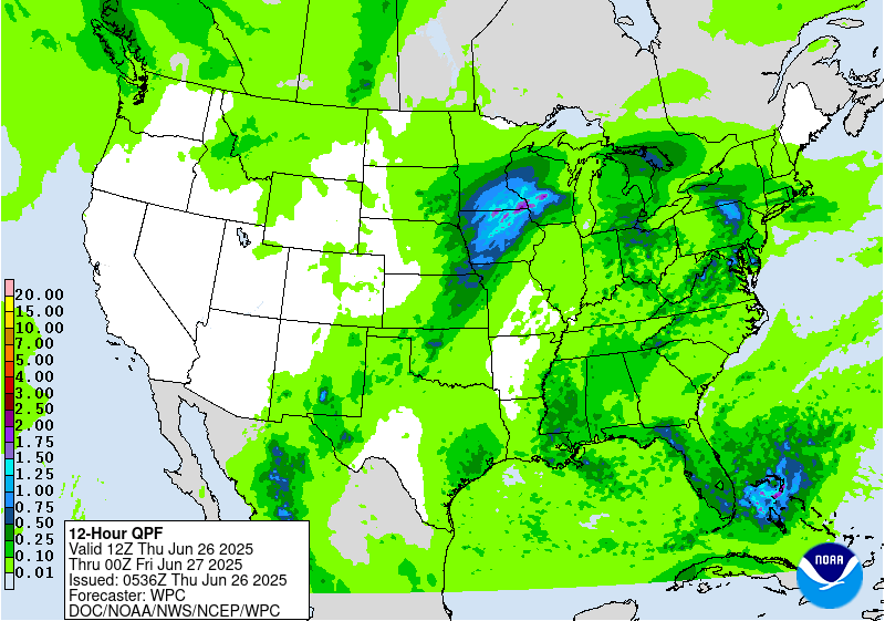
...Central Plains into the Upper Great Lakes...
Upper shortwave trough across the Northern Plains early Thu will
pivot eastward across the Upper MS Valley and Upper Great Lakes
region later Thu and Thu night. Enhancing the deep-layer forcing
will be the curved 90kt upper level jet streak that will be
skirting the U.S.-Canadian border. Ahead of the upper shortwave
trough/surface front -- 850-700 mb moisture flux anomalies are
noteworthy (1.5-2.0 standard deviations above normal), as is the
0-6km bulk shear values (35-45+ kts). This will likely support more
widespread, organized convective line segments later this
afternoon/evening and into the overnight across the elongated
Slight Risk area. Compared to yesterday's Day 2 ERO, based on the
latest guidance trends we did nudge the Slight slightly farther
east across northwest MO and southeast IA. The 00Z CAMs show 24hr
max QPF generally in the 3-5" range within the Slight Risk area,
which is supported by the HREF and RRFS 24hr QPF probabilities.
Multiple CAMs (including the 00Z RRFS) show isolated totals
exceeding 5" across eastern KS.
...Mid Atlantic...
Most of the CAMs show more widespread slow-moving convective
clusters within a newly-hoisted Slight area, initiating along the
lee-side trough and quasi-stationary, backdoor front. Relatively light
(generally 20kt or less) deep-layer shear would suggest pulse-
type durations for the heaviest rains, but nevertheless both the
HREF and RRFS do show pockets of elevated probabilities with >2"/hr
rainfall rates by mid-late afternoon into Thu evening. Therefore
given the favorable thermodynamic profile (1.75-2.00" PWs and max
CAPEs 2000-3000 J/Kg), the likelihood of slow cell motions with the
potential for repetitive convection along these boundaries would
support a low-end Slight Risk across the northern Mid Atlantic
(northern VA into eastern MD and Eastern PA), despite the lack of
strong synoptic/ kinematic support.
...Parts of the Lower MS Valley, TN Valley, and Southeast...
Scattered to widely scattered thunderstorms over much of the
south-central to southeastern CONUS will yield some heavy rainfall
prospects during the day Thursday with a decay in coverage once we
lose diurnal heating. The main areas of interest will lie along
the terrain in the Southern Appalachians and along the Gulf coast
where the remnants of a migrating TUTT cell will maintain a focal
point for heavy convective prospects during the period. Best threat
for any flash flooding will be tied to the complex topography and
urban settings where runoff capabilities are highest. Relatively
modest HREF probs for >3" (40-60%) were noted across portions of
MS/LA and especially along the west coast of the FL Peninsula. For
now the risk appears to be a 'high end' Marginal, i.e. mainly an
isolated flash flood risk, largely due to the pulse/short-fused
nature of the more intense rainfall rates and relatively high FFG
values.
...New Mexico...
Isolated to scattered thunderstorms across the Sacramento's and
adjacent desert will maintain at least some threat for flash
flooding given wet antecedent conditions following previous multi-
day convective impact in prior periods. Coverage and intensity of
convection will be less than previous days as we lose the benefit
of the RER jet dynamics that have assisted in the recent days.
Still, remnant elevated moisture and sufficient buoyancy within
the confines of far West TX up through Southern and Eastern NM will
maintain a posture of diurnally driven thunderstorms with locally
heavy rainfall across the above areas. Heaviest thunderstorms will
be capable of 1-2" with the peak QPF max probably closer to 3" as
noted by modest HREF neighborhood probabilities for >3" with a
decline to 0% for >5". The previous MRGL risk was maintained.
Hurley
Day 1 threat area:
www.wpc.ncep.noaa.gov/qpf/94epoints.txt
Excessive Rainfall Discussion
NWS Weather Prediction Center College Park MD
449 AM EDT Thu Jun 26 2025
Day 2
Valid 12Z Fri Jun 27 2025 - 12Z Sat Jun 28 2025
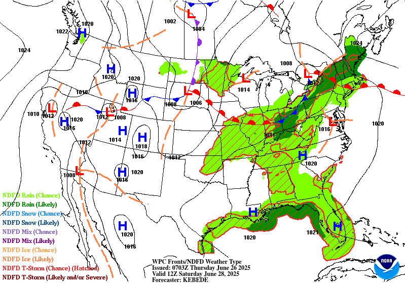
...THERE IS A SLIGHT RISK OF EXCESSIVE RAINFALL OVER PORTIONS OF
NORTHERN NEW YORK AND NORTHERN NEW ENGLAND...
...Northern NY-New England...
The forecast for a focused corridor of heavy rainfall associated
with an MCS and trailing convection crossing from southeastern
Canada into portions of Update New York/northern New England
remains on track. While there are expectedly some variances on the
possible MCS path which add some east-west uncertainty, all
guidance is still in good agreement that the track will clip areas
south of the international border bringing an attendant flash flood
threat. Deterministic guidance indicates the potential of rainfall
totals between 1-3", with ensemble probabilities of 2"+ between
15-25%. A small eastward adjustment of the Slight Risk area was
added based on these latest ensemble probabilities. Elsewhere,
prior forecast has remained consistent.
...Northern Plains...
A quick moving shortwave across the North-Central tier of the CONUS
will lead to scattered thunderstorm activity capable of locally
heavy rainfall and flash flood prospects. The best threat will be
over Northern ND into the Red River area where some urbanized zones
will have a greater threat for flash flooding. A quick 1-3+" is
likely anywhere over Central ND into Northwest MN. This threat is
within the lower end of the MRGL risk threshold and will be
monitored closely to see if the risk is warranted, or needs any
expansion.
...West Texas into New Mexico...
Continued threat of widely scattered thunderstorms across far West
TX into NM will allow for isolated flash flood concerns over areas
that will have seen several days of heavy convective impacts with
compromised FFG's. Local 1-2" is possible in the period with the
highest threat likely over the Sacramento's down through the
Guadalupe Mtns. and adjacent valleys. A MRGL risk was maintained to
cover for the threat.
Day 2 threat area:
www.wpc.ncep.noaa.gov/qpf/98epoints.txt
Excessive Rainfall Discussion
NWS Weather Prediction Center College Park MD
449 AM EDT Thu Jun 26 2025
Day 3
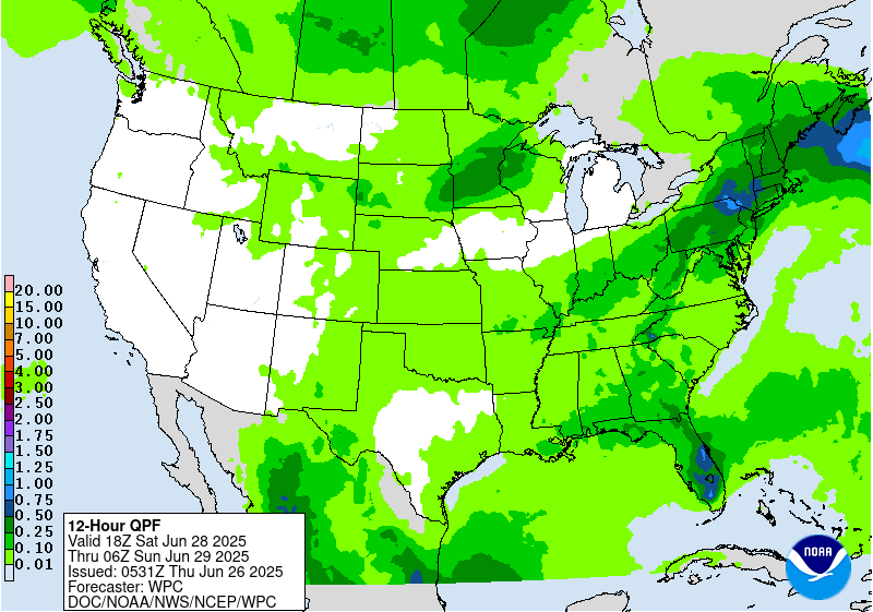
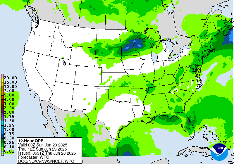
Valid 12Z Sat Jun 28 2025 - 12Z Sun Jun 29 2025
...THERE IS A MARGINAL RISK OF EXCESSIVE RAINFALL ACROSS PORTIONS
OF THE NORTHERN PLAINS AND UPPER MIDWEST, THE NORTHEAST, AND
SOUTH-CENTRAL NEW MEXICO...
...Northern Plains and Upper Midwest...
Next approaching upper shortwave trough, with a 90kt upper level
jet streak on the lee side, will generate a compact area of fairly
robust, transient deep-layer forcing over the outlook area later in
the period (especially Sat night). MUCAPEs are expected to soar
within the warm sector prior to the surface cold frontal passage --
i.e. aoa 4,000 J/Kg per the GFS. This along with PWs getting near
1.75" will lead to more organized, widespread convection by
Saturday night as the activity likely grows upscale with the
increasing pre-frontal low-level inflow (30-40kts at 850 mb). The
00Z guidance indicates significant latitudinal spread in the
heavier QPF, and as a result, have maintained the Marginal Risk
from yesterday's Day 4 ERO. However, the potential for an upgrade
to Slight is certainly plausible given the kinematic and
thermodynamic profile, especially after 00Z Sun when the Corfidi
Vectors decrease to 10kt or less (thereby enhancing the risk for
cell training).
...Northeast...
Upper shortwave trough pushes across the Northeast by late Sat,
then off the coast Sun morning. The bulk of the rainfall will fall
during the first half of the period (during the day Sat),
coinciding with the most favorable pre-frontal deep-layer
instability and moisture (PWs 1.75-2.00+ inches). The 00Z guidance
shows considerable spread with the heaviest QPF, though are fairly
similar with the max totals (1.5-3.0"). Given the spread in the
model QPFs, along with the progression of the front and fairly
quick diminishment in instability after 00Z Sun, for now will
maintain the Marginal Risk.
...New Mexico...
Maintained a targeted Marginal Risk area over/near the Sacramento
Mtns, particularly the burn scar areas from the 2024 fires (Blue 2,
South Fork, and Salt burn scars). QPF trends (coverage, intensity)
are similar to Day 2, with the moist S-SE low-level upslope flow
likely resulting in a concentrated area of heavier rainfall across
the Sacramento Mtns and eastern foothills. The flash flood
potential is expected to remain isolated/localized.
Hurley
Day 3 threat area:
www.wpc.ncep.noaa.gov/qpf/99epoints.txt
Extended Forecast Discussion
NWS Weather Prediction Center College Park MD
259 AM EDT Thu Jun 26 2025
Thunderstorms are likely to form ahead of the broad but shallow
upper trough and a surface frontal boundary in the Upper Midwest to
central Plains Sunday. Global models have already been showing
high instability with MUCAPE 4000-6000 J/kg for this region, so
strong storms are possible, and this will also support heavy rain
rates that could cause flash flooding. A Marginal Risk is in place
in the Upper/Middle Mississippi Valley back into the south-central
Plains for the Day 4/Sunday ERO. By Monday the setup will be
similar, but with the trough and cold front pressing southeast. A
large Marginal Risk is located along and ahead of the front from
the Ohio/Tennessee Valleys, Mid/Lower Mississippi Valley, and the
south-central Plains where storms are likely in the moist and
unstable airmass on Day 5/Wednesday. For both days, further
refinements may be needed in future cycles, including possible
embedded Slight Risks, but model agreement in the specifics remains
low for now. The front will continue to push eastward Tuesday,
leading to a wet day in the Northeast/Mid-Atlantic before drying
out midweek, and southward for thunderstorm chances across the
Southeast Tuesday-Wednesday. Even before the front approaches,
scattered thunderstorms are likely farther south in the broad warm
sector as well. There will be less forcing for organization and
sustaining of storms across the southern tier away from the upper
jet, but instability could allow for heavy rain rates that may
cause nonzero chances of localized flash flooding, but that are
likely dependent on smaller scale boundaries and are less
predictable at this point. One area of focus that the models show
for some heavier rain is across the central to eastern Gulf Coast
region. Will monitor if there will be flash flooding concerns there
but it would have to battle with very high flash flood guidance.
Monsoonal moisture is likely to increase next week in the
Southern/Central Rockies and Plains with southerly flow under the
upper ridge, thus increasing coverage of and rain amounts in
storms. Marginal Risks are in place for the southern High Plains
Day 4/Sunday and stretching north into eastern Colorado Day
5/Monday as the back end of the front nears. Areas like the
Sacramento Mountains, where the steep terrain and burn scars cause
the area to be particularly sensitive to rain, are likely most
vulnerable to rain causing potential flash flooding, especially
with wet antecedent conditions there.
Elsewhere, showers and storms may develop across parts of the
Great Basin Monday and toward the Northern Rockies by Tuesday. Then
depending on a shortwave, rain chances are forecast to increase in
the north-central U.S. by midweek.
Temperatures are forecast to be around 5-10 degrees above average
across the Midwest/Great Lakes early next week, while the southern
half of the Plains to Southeast can expect typical summer heat.
HeatRisk shows some Major (level 3 of 4) areas in these regions,
indicating heat levels that affect anyone without effective cooling
and/or adequate hydration. Temperatures and dewpoints will
decrease behind the cold front as it progresses southeast. Farther
west, building heat is expected next week as an upper ridge takes
hold. Temperatures in the Northwest are likely to be 10-15 (locally
20) degrees above normal, for highs nearing 100F. In the Desert
Southwest, temperatures a few degrees above already high averages
will equate to 100s and 110s. Moderate to Major HeatRisk is shown
for much of the Interior West peaking Monday-Tuesday.
Tate


