Excessive Rainfall Discussion
NWS Weather Prediction Center College Park MD
854 PM EDT Tue Jun 24 2025
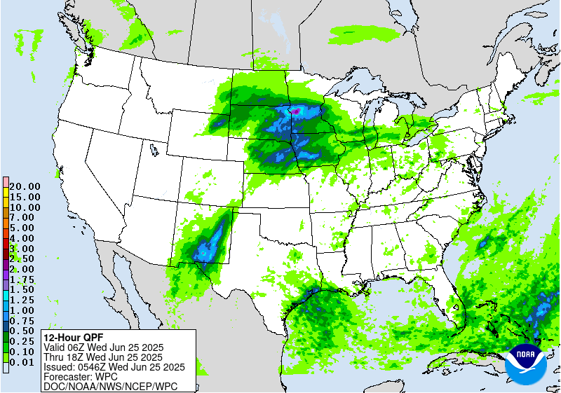
Day 1
Valid 01Z Wed Jun 25 2025 - 12Z Wed Jun 25 2025
...THERE IS A MODERATE RISK OF EXCESSIVE RAINFALL OVER PORTIONS OF
CENTRAL AND SOUTHERN NEW MEXICO...
...New Mexico...
A strong warm core ridge centered over the Ohio Valley and Mid-
Atlantic with its western extent pushing back west beyond the
eastern portions NM. A steady south-north progression within the
mid and upper levels will send numerous smaller shortwave
perturbations through NM. Anomalous moisture ranking in the 99th
percentile via NAEFS and ECENS Climatological percentiles will
remain parked over the region. Morning activity left some southern
areas out of the mix today, but the 18z HREF probabilities of 0.5"+
suggest that this region remains a threat overnight, possibly from
convection moving in from the west. Local topographic effects
within this pattern will yield some significant rainfall potential
over areas that are prone to flash flooding, especially with the
burn scars still present near Ruidoso creating higher runoff
capabilities.
The difference the past 24 hrs. has been the expected influence of
the approaching trough out west providing a reinforcement of the
trailing upper jet with the amplitude of the pattern creating more
room further west for large scale ascent, and moisture advection
back into the western half of NM, even sneaking into Southeast AZ.
The entire evolution has spurred scattered to widespread
thunderstorm activity over the aforementioned regions with cold
pool mergers from storms likely to produce some upscale growth in
the evening as the convergence of cold pools will act to spawn more
multi-cell modes. The flash flood threat will linger through the
overnight time frame before finally settling down closer to
Wednesday AM.
The various risk levels were barely nudged as recent radar
reflectivity trends and 18z HREF probabilities of heavy rainfall at
various threshold indicate that local 2-4" totals remain possible
into early Wednesday.
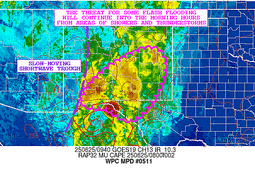
...Central Plains to Midwest...
Thunderstorms are most numerous near the NE/CO border and northwest
MO at this time as a shortwave enhances activity. A ring of fire
type of convective pattern remains from NM through portions of the
High Plains into the Central Plains and Midwest towards the Great
Lakes around the northwest periphery of the warm core ridge.
Activity is along and near a quasi- stationary front bisecting the
areas above. Areas of northeast KS, southwest IA, and northwest MO
are the main focus for flash flood concerns with saturated grounds.
Thunderstorms are likely to carry east and northeast into
Wednesday morning towards the Great Lakes.
A strong 700-900 kg/ms IVT pulse is advecting northeastward into
the Central Plains and Midwest, so the heavy rain threat with
2-3"/hr rates will certainly have potential for basically anywhere
in the Central Plains/Midwest domain. Recent trends suggest that
convection moving across southern NE would be a concern over the
next several hours. The nocturnal LLJ allows the stationary front
to begin lifting north in the form of a warm front tonight, in
theory. The mean layer flow orients more parallel to the front
creating an environment capable for cells to mature and begin
training over areas within proxy to the boundary.
Roth/Kleebauer
Day 1 threat area:
www.wpc.ncep.noaa.gov/qpf/94epoints.txt
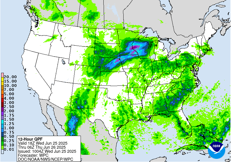
Excessive Rainfall Discussion
NWS Weather Prediction Center College Park MD
347 AM EDT Wed Jun 25 2025
Day 1
Valid 12Z Wed Jun 25 2025 - 12Z Thu Jun 26 2025
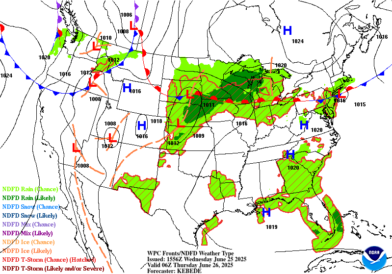
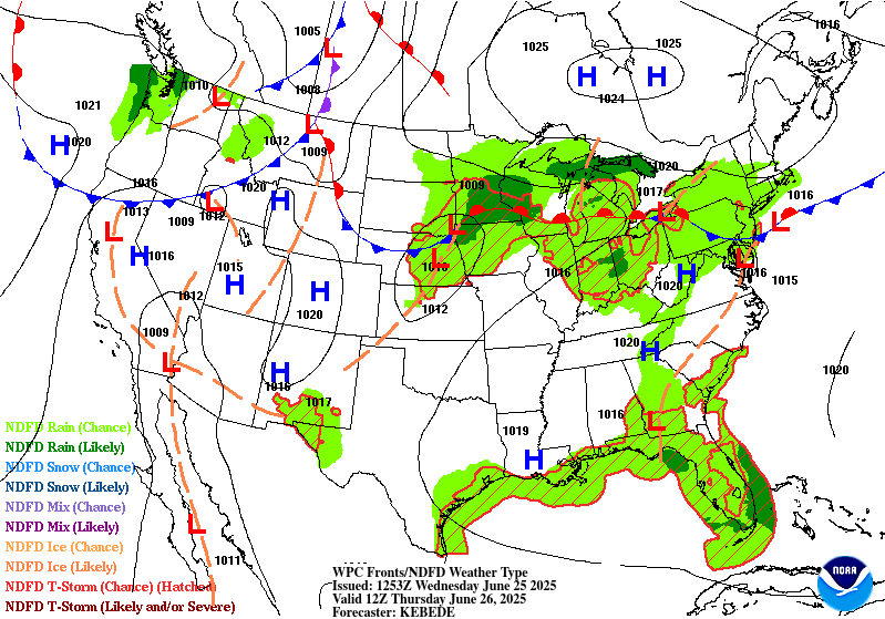
...THERE IS A SLIGHT RISK OF EXCESSIVE RAINFALL OVER PORTIONS OF
NEW MEXICO, CENTRAL PLAINS AND MIDWEST...
...New Mexico...
Despite a bit less areal coverage anticipated for convection
across New Mexico for Wednesday, scattered thunderstorms will still
cause problems after daytime initiation as ample heating during
the prime destabilization window (16-21z) will yield another threat
of heavy rainfall across the terrain and adjacent valleys across
NM. Main jet to the north will lift out of the area allowing for
less of a large scale ascent pattern that could maximize any
convective pattern over the region. Remnant elevated moisture
(PWATs) running between 1-2 standard deviations above normal on
the western flank of our ridge will still be located across the
state leaving an environment capable of heavy rainfall in any
convective cores that develop. Impacts the previous period were
felt over a large portion of the state leading to generally lower
FFG's bisecting much of the area expected to see a chance for
convection today. Latest HREF neighborhood probs for >3" are
running pretty high (50-70%) across places like El Paso and points
north within part of the Sacramento's, an area we have highlighted
the past several days. Modest probs (20-40%) for >3" extend all
the way up into the Sangre de Cristos with some smaller relative
mins mixed into the areal coverage. This is more a testament to the
valley/terrain components littered over the state, so not all areas
will see impactful rainfall with this convective evolution.
The signal is sufficient enough to warrant a broad SLGT risk
within the state extending down through far West TX given the
current CAMs interpretation of scattered heavy convection likely to
impact portions of El Paso and Hudspeth counties through part of
the period. Some strong cells could even develop across the NM
Caprock as inferred by a few hi-res deterministic, likely due to
the favorable instability tongue positioned over the eastern side
of the state behind a vacating surface trough. High end SLGT risk
is favored for areas across Southern NM up through Central portion
of the state with the favored areas likely including the
Sacramento's, Sangre de Cristos, and areas within and surrounding
El Paso.
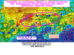
...Central Plains to Midwest...
Convective pattern across the Plains and Midwest at the end of the
D1 will translate northward into the Upper Mississippi Valley with
organized convection over NE/IA and SD/MN converging along the
propagating warm front leading to a swath of heavy rainfall across
much of the Southern 1/3rd of MN into Western WI. Beginning to see
the CAMs come into better agreement on the anticipated convective
evolution with a dual QPF maxima most likely situated over the area
between Aberdeen, SD to Minneapolis with a consensus on the
heaviest precip along and south of I-94 in MN with a bullseye
generally overhead or very close to Minneapolis proper. The second
maxima is positioned across Northeast NE into Northern IA to the
southern reaches of the MN border where a multi-round convective
impact forecast is being depicted in guidance as the initial round
in the morning will give way to a short break before redevelopment
occurs back along the frontal positioning bisecting the area. A
strong IVT pulse currently aligned from KS up through Eastern NE
has helped push PWATs closer to the 99th percentile around Omaha
this evening with the 00z RAOB out of KOAX depicting a PWAT of
1.94", putting this just below the daily climatological max for the
day (25/00z) and well above the 90th percentile for not just the
period, but even for the sites general historical record. This same
airmass is what's progged to advect northeast into MN and Western
WI by the time we reach tomorrow afternoon, a signal that would
prime any convective impacts to likely provide some prolific heavy
rain cores in stronger cells impacting the region. With the proxy
of the front and the environment in place, there's ample evidence
that some areas across the Midwest will see between 3-6" with the
5-6" range within reason as inferred by modest >5" neighborhood
probs (20-35%) in the latest HREF output. This same signal is
situated over the two defined maxima in guidance with the >3"
signal between 50-80% for both areas.
Considering all of the above factors and relatively good agreement
within the 00z guidance this evening, the previous SLGT risk was
maintained and leans towards a higher end risk with some prospects
of a targeted upgrade in any of those outlined forecast maxima by
the next update. Widespread significant impacts are not
anticipated at this time, but locally considerable flash flooding
is plausible in the setup. SLGT risk extends into the Western Great
Lakes on the eastern flank and down into Southern NE on the
southwest flank of the risk with potentially for widely scattered
flash flood prospects as convection impacts both areas during the
period.
...Mid Atlantic...
The northern fringe of our powerful ridge centered over the Ohio
Valley and Mid Atlantic will begin breaking down through the course
of Wednesday with an increase in PWATs likely to advect over the
area as moisture finally, "rounds the bend" over the Great Lakes
and pushes into the Northeast CONUS. Mean flow will shift more
northwesterly by the time we reach the afternoon hrs with a
significantly buoyant environment in place and generally less
capping as our ridge weakens. A few small mid-level perturbations
analyzed over the Great Lakes currently will sweep southeastward
into PA by morning and eventually cross over the region by peak
diurnal maximum. The combination of a very buoyant environment
with focused ascent will lead to scattered thunderstorm development
across much of PA, Northern WV, and into the Central Mid Atlantic
domain with sights on Southern NJ/MD/Northern VA. MUCAPE between
2500-4000 J/kg across the Central Mid Atlantic and a maxima near
5000 J/kg out in the Central Appalachians will be plentiful to help
boost convective magnitude as cells develop and mature on their
way to the southeast. Cell motion will thankfully be somewhat
progressive leading to a low prospect for training. However, PWATs
running ~2 deviations above normal (1.8-2.1") across much of the
region will certainly benefit heavy rain prospects with hourly
rates likely to settle between 1-2"/hr in any given location with
some stronger cores possibly hitting upwards of 2-3"/hr on average
with higher intra-hour rates. A MRGL risk remains in effect for
much of the Mid Atlantic with the northern periphery of the risk
area as far north as NY state with the southern edge down into
Central VA.
...Southeast...
A migrating TUTT cell off the coast of FL will continue to
propagate westward and provide favorable ascent within the proxy of
the Southeastern CONUS. Unstable airmass and large scale ascent
will aid in scattered thunderstorms developing all across the South
with the highest threat of heavy rainfall centered over Southern NC
down through Central SC into Southern GA where instability (>3000
J/kg of SBCAPE) is forecast to be highest. Heavy rainfall of
2-3"/hr is anticipated in some of the stronger convective cores
leading to isolated flash flood prospects in any urbanized
settings. Given the more focused ascent pattern provided by the
advancing TUTT, the threat sneaks into the lower end of the MRGL
risk threshold, so a broad MRGL was positioned over much of the
Southeast to cover the threat.
Kleebauer
Day 1 threat area:
www.wpc.ncep.noaa.gov/qpf/94epoints.txt
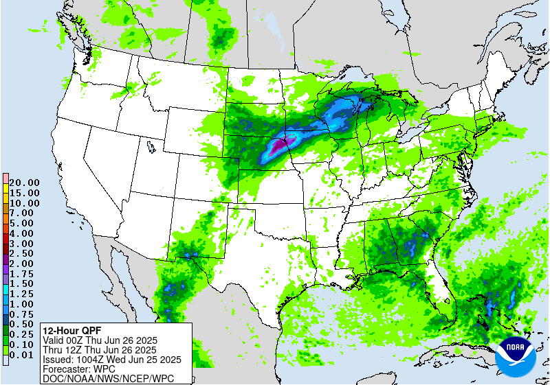
Excessive Rainfall Discussion
NWS Weather Prediction Center College Park MD
347 AM EDT Wed Jun 25 2025
Day 2
Valid 12Z Thu Jun 26 2025 - 12Z Fri Jun 27 2025
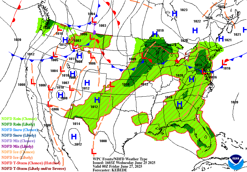
...THERE IS A SLIGHT RISK OF EXCESSIVE RAINFALL OVER PORTIONS OF
THE CENTRAL PLAINS, MIDWEST AND NORTHERN GREAT LAKES...
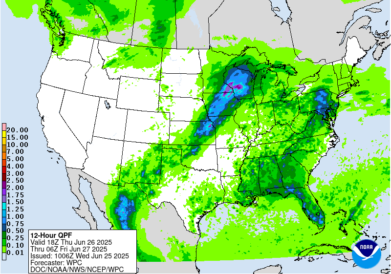
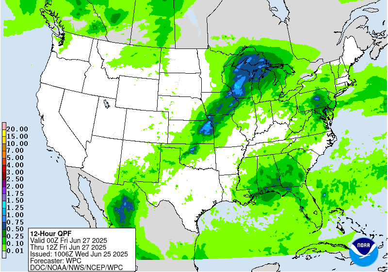
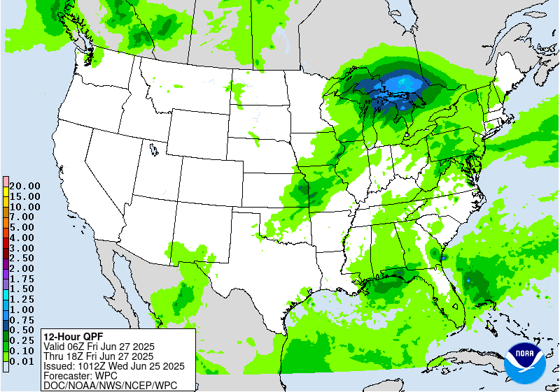
...Central Plains into Great Lakes...
The final shortwave in the progression bleeding over from the
previous D1 time frame will continue pushing northeast before
finally vacating the Upper Midwest later on Thursday. Heavy rain
threat will continue over parts of MN and WI before eventually
impacting the Western U.P. of Michigan before its departure.
Instability across the region will be significantly lower than
previous days with the warm front becoming stationary prior to
reaching the southern shores of Lake Superior. The threat for flash
flooding is most notably in the first 6-12 hr window of the
forecast with a sharp decline in the threat afterwards as the
pattern shifts with the ridge expected to be breaking down. 1-2"
with locally higher amounts (upwards of 4") will allow for flash
flooding in any area from IA up through MN/WI, especially in places
where significant rainfall has occurred in prior periods. A
secondary maxima is forecast across portions of the Central Plains
down around KS/Northwest MO as a surface low over the Northern
Plains migrates eastward and drags a cold front across the Plains
and adjacent Midwestern areas. Guidance has been keying on a
secondary QPF maxima located within that corridor as thunderstorms
form along a defined instability axis with mid-level ascent
availability from a trailing shortwave over the region and some
marginal convergence ahead of the cold front to the north and
northwest. Locally 2-4" are possible in this region, an area that
has had the benefit of multiple heavy rain instances the past
48hrs. A broad SLGT risk remains in place over the Northern Great
Lakes and Upper Midwest, now extending back into parts of the
Central Plains to cover for the additional threat trailing the
surface reflection.
...New Mexico...
Isolated to scattered thunderstorms across the Sacramento's and
adjacent desert will maintain at least some threat for flash
flooding given wet antecedent conditions following previous multi-
day convective impact in prior periods. Coverage and intensity of
convection will be less than previous days as we lose the benefit
of the RER jet dynamics that have assisted in the recent days.
Still, remnant elevated moisture and sufficient buoyancy within
the confines of far West TX up through Southern and Eastern NM will
maintain a posture of diurnally driven thunderstorms with locally
heavy rainfall across the above areas. Heaviest thunderstorms will
be capable of 1-2" with the peak QPF max probably closer to 3" as
noted by modest HREF neighborhood probabilities for >3" with a
decline to 0% for >5". The previous MRGL risk was maintained and
expanded to encompass areas that will be at highest risk for flash
flooding due to the antecedent conditions and potential
thunderstorm activity.
...Mid Atlantic...
Disturbance rounding the northern periphery of our massive ridge
will ultimately slide down through the Mid Atlantic during the
mid to late-afternoon hrs. on Thursday. The combination of strong
diurnal destabilization during the daytime and prominent moisture
lingering over the area will create a very buoyant environment
capable of strong thunderstorm genesis anywhere from NY state down
through the Central Mid Atlantic including; MD/PA/DE/Northern WV
and VA. The key to this setup compared to the D1 period will be a
targeted focus within the confines of cold front pressing southward
out of the Northern Mid Atlantic Thursday afternoon and evening.
High pressure over Northern New England into Quebec will act as a
forcing mechanism to propel the front with a wedged signature
occurring east of the Appalachian front. Concern is for
thunderstorm genesis along the boundary, but a setup conducive for
eventual back-building along the front as it migrates into Northern
VA and will hit a wall in its progression. Guidance has increased
area maximum within the QPF output with some local spots seeing
2-4" over portions of the Central Mid Atlantic, mainly south of the
PA Turnpike down into the Northern Shenandoah and points east,
including the DC/Balt metro. These heavier returns will be more
isolated in coverage, but could still provide locally significant
impacts if over the wrong area. For now, have maintained the MRGL
risk, but a targeted SLGT risk could be added over parts of the
region if the signal becomes more concrete on where the heaviest
precip will align.
...Southeast...
Scattered to widely scattered thunderstorms over much of the
Southeastern CONUS will yield some heavy rainfall prospects during
the day Thursday with a decay in coverage once we lose diurnal
heating. The main areas of interest will lie along the terrain
in the Southern Appalachians and along the Gulf coast where the
remnants of a migrating TUTT cell will maintain a focal point for
heavy convective prospects during the period. Best threat for any
flash flooding will be tied to the complex topography and urban
settings where runoff capabilities are highest. Relatively modest
HREF probs for >3" (20-35%) during the 12-00z time frame on D2 are
littered over the Southeast leading to a broad MRGL risk to cover
for all the local threats. The risk lies within the lower end of
the threshold and some adjustments are possible pending CAMs
conjecture.
Kleebauer
Day 2 threat area:
www.wpc.ncep.noaa.gov/qpf/98epoints.txt
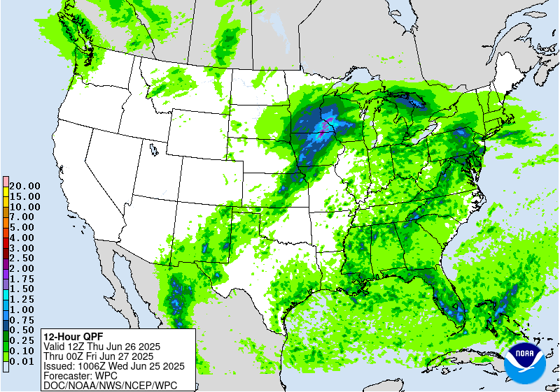
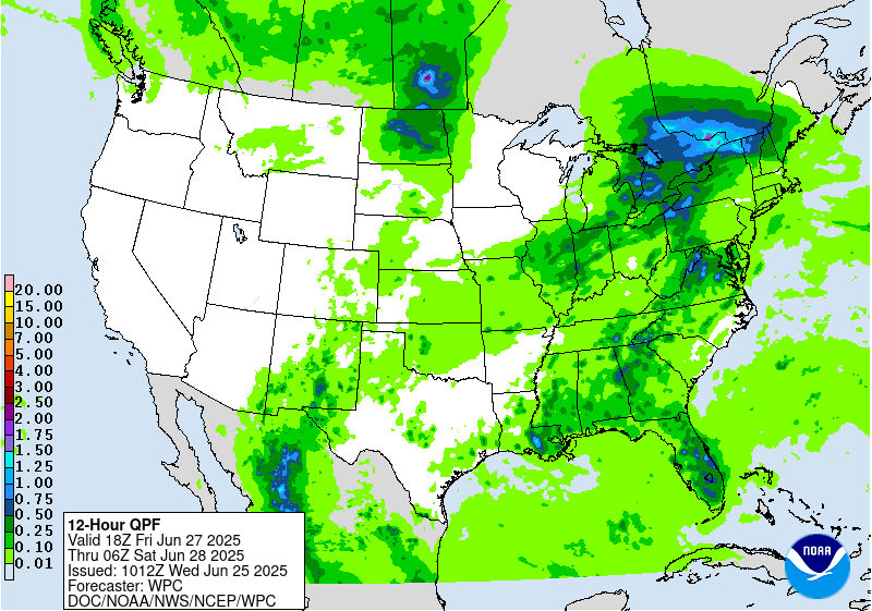
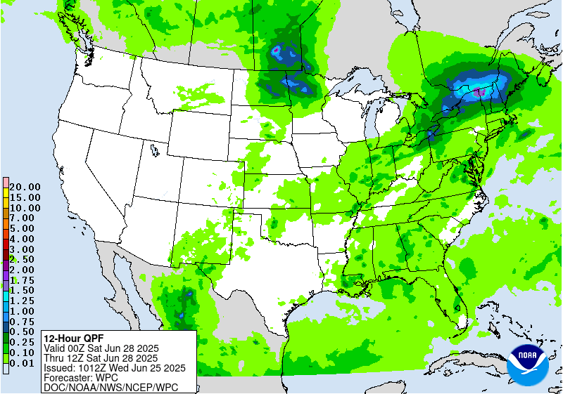
Excessive Rainfall Discussion
NWS Weather Prediction Center College Park MD
347 AM EDT Wed Jun 25 2025
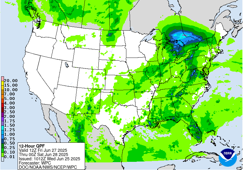
Day 3
Valid 12Z Fri Jun 27 2025 - 12Z Sat Jun 28 2025
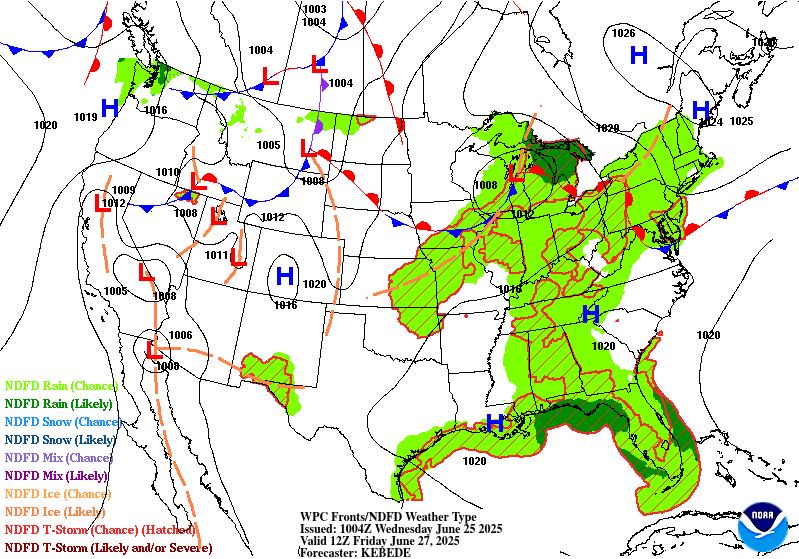
...THERE IS A SLIGHT RISK OF EXCESSIVE RAINFALL OVER PORTIONS OF
NORTHERN NEW ENGLAND...
...Northern New England...
A strong shortwave originating from the Midwest the period prior is
forecast to cross through the Great Lakes and continue migrating
into Southeastern Canada as we enter D3. A surface low will be moving
east-northeast through the Lakes into neighboring Ontario Province
by Friday afternoon which will aid in regional ascent and a
strengthening low level convergence regime tied evolving synoptic
pattern across Canada and the Northeastern U.S. Assessment of the
theta_E field signals a sharp northern gradient within the
instability regime as surface ridging downstream and warm frontal
approach on the lead side of the low will create quite a thermal
gradient across Ontario/Southern Quebec, extending into Northern
New England. This will lay the foundation for an anticipated
development of an MCS upstream over Ontario in conjunction to the
shortwave arrival and aided large scale ascent within the tail end
of a jet streak exiting over Quebec into ME. The progression of
the MCS will be important to discern as the complex will likely
spur a threat of heavy rainfall, and certainly some prospects of
back-building along the flanking side of the disturbance within the
thermal gradient outlined. Models are right on the edge in a
majority of cases for significant rains to impact NY North Country
over into Northern VT as they will be closest the complex on its
progression, and lie right along that thermal gradient in place.
Ensemble bias correction this evening is extremely bullish in its
presentation, a lot likely owed to an aggressive 00z GFS output,
but even other guidance is relatively close with some impressive
totals located along and just north of the border. ECMWF AIFS ML
guidance is right within the median outcome with the heaviest
centered right at the International border with the heaviest precip
just to the north. Given some of the sensitivities in the area over
Northern VT into North Country, and in coordination with the local
Burlington WFO, a small SLGT risk has been added over the
aforementioned area to cover for the threat. If trends for the
heavier precip end up shifting north, a removal is possible, but
considering the potential, the higher risk was added to aid
messaging and correlate with the latest ensemble means.
...Northern Plains...
A quick moving shortwave across the North-Central tier of the CONUS
will lead to scattered thunderstorm activity capable of locally
heavy rainfall and flash flood prospects. The best threat will be
over Northern ND into the Red River area where some urbanized zones
will have a greater threat for flash flooding. A quick 1-3" is
likely anywhere over Central ND into Northwest MN. This threat is
within the lower end of the MRGL risk threshold and will be
monitored closely to see if the risk is warranted, or needs any
expansion.
...West Texas into New Mexico...
Continued threat of widely scattered thunderstorms across far West
TX into NM will allow for isolated flash flood concerns over areas
that will have seen several days of heavy convective impacts with
compromised FFG's. Local 1-2" is possible in the period with the
highest threat likely over the Sacramento's down through the
Guadalupe Mtns. and adjacent valleys. A MRGL risk was maintained to
cover for the threat.
Kleebauer
Day 3 threat area:
www.wpc.ncep.noaa.gov/qpf/99epoints.txt
Extended Forecast Discussion
NWS Weather Prediction Center College Park MD
257 AM EDT Wed Jun 25 2025
An initial shortwave and weak low pressure system along a frontal
boundary could bring locally heavy rain in the Northeast lingering
into Saturday. Ample moisture (PWs likely over the 90th percentile)
and some instability could allow for heavy rain rates and possible
flash flood concerns. Continue to depict a Marginal Risk in the
Day 4/Saturday ERO for this activity. Farther west, thunderstorms
are likely to form ahead of the broader upper trough and the
surface frontal boundary in the northern Plains to Upper Midwest
Saturday. Global models have already been showing high instability
with MUCAPE 4000-6000 J/kg for this region, so severe storms are
likely, and this will also support heavy rain rates that could
cause flash flooding. A similar setup is likely on Sunday, just
with the cold front a bit more progressive southeastward. This
allows for a broad Marginal Risk in the Upper/Middle Mississippi
Valley back into the central Plains for the Day 5/Sunday ERO.
Another concern is the wet antecedent conditions that may be in
place by then, after heavy rain in the short range period.
Refinements may be needed in future cycles since there is
uncertainty in the placement of heaviest rain.
Over the weekend into early next week, scattered thunderstorms are
likely farther south in the broad warm sector as well. There will
be less forcing for organization and sustaining of storms across
the central and southern tier away from the upper jet, but
instability could allow for heavy rain rates that may cause nonzero
chances of localized flash flooding, but that are likely dependent
on smaller scale boundaries and are less predictable at this
point. One area of focus that the models show for some heavier rain
is across the central to eastern Gulf Coast region. Will monitor
if there will be flash flooding concerns there but it would have to
battle with very high flash flood guidance. Into the workweek as
the main cold front continues to press south and east, heavier rain
and thunderstorms could stretch across the south-central Plains
into the Ohio/Tennessee Valleys and into the East.
Monsoonal type moisture is likely to increase over the
southern/central Rockies and Plains where there could be a weakness
in the upper ridge. On Saturday main flash flooding concerns will
be across the Sacramento Mountains, where the steep terrain and
burn scars cause the area to be particularly sensitive to rain, so
WPC is covering this with a small Marginal Risk in the Day 4 ERO.
But moisture levels and thus coverage and rain amounts of storms
should increase into early next week. A Marginal Risk is in place
across eastern New Mexico and far West Texas in the Day 5/Sunday
ERO with this activity. These areas are seeing heavy rain in the
near term, and the wetter antecedent conditions enhance flash
flooding concerns.
By the weekend, heat will be much less extreme than currently, but
above average temperatures by 5-12 degrees are likely across the
north-central U.S., Mississippi Valley, and into southern parts of
the Mid-Atlantic. HeatRisk shows some Major (level 3 of 4) areas in
these regions, indicating heat levels that affect anyone without
effective cooling and/or adequate hydration. Meanwhile the
Northeast will be much cooler behind a backdoor cold front. Into
next week, slightly above average temperatures will shift east
ahead of a cold front and moderate. Farther west, building heat is
expected next week as an upper ridge takes hold. Temperatures in
the Northwest are likely to be 10-15 (locally 20) degrees above
normal, for highs nearing 100F. In the Desert Southwest,
temperatures a few degrees above already high averages will equate
to 100s and 110s. Moderate to Major HeatRisk is shown for much of
the Interior West.
Tate


