Excessive Rainfall Discussion
NWS Weather Prediction Center College Park MD
855 PM EDT Sat Jun 21 2025
Day 1
Valid 01Z Sun Jun 22 2025 - 12Z Sun Jun 22 2025
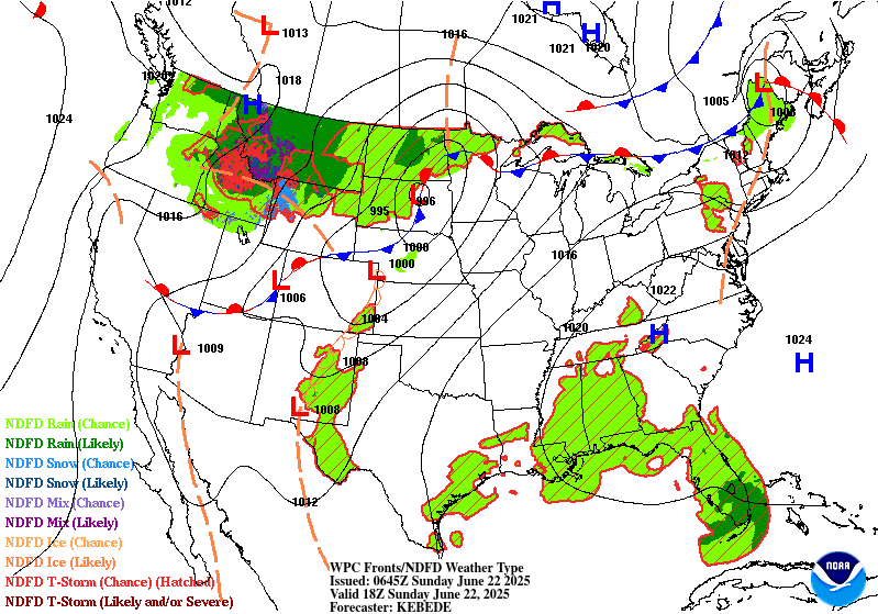
...THERE IS A MARGINAL RISK OF EXCESSIVE RAINFALL FOR PORTIONS OF
THE NORTHERN GREAT LAKES AND THE INTERIOR NORTHEAST...
01Z Update...
With some minor adjustments, Marginal Risk areas were maintained
over portions of northern Michigan, as well as northern New York
and Vermont.
Across northern Michigan, the latest HRRR has shown an uptick in
amounts centered near the Tip of the Mitt and the eastern U.P.,
where storms may develop and lift north from a slow-moving
boundary. While the latest mesoanalysis shows plenty of moisture
(PWs 1.8+ inches) and instability (MUCAPE 3000+ J/kg), it also
shows a fair amount of CIN, which along with a capped environment,
is likely to hinder any widespread development.
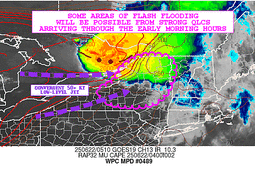
Further to the east, the complex developing over southwestern
Ontario/southern Quebec is expected to move into northern New York
and New England tonight. The latest guidance is not indicating
widespread heavy amounts, however a period of training may
contribute to some localized heavier totals (1-2 inches) and an
isolated flash flood threat.
Pereira
Previous Discussion...
...Northern Great Lakes...
Convection will likely be ongoing at 12z this morning across
portions of the UP of MI. It still looks like the storm mode should
be a progressive squall line, which would limit the duration of
heavy rainfall and flash flood risk. However even the progressive
convection will be capable of heavy rates, with a high likelihood
of some 1"+ per hour totals, and a low chance of 2" per hour. Also
can not rule out some brief backbuilding/training on the southwest
flank of convection as it moves eastward. So while the flash flood
risk should be relatively low, localized hydrologic issues can not
be ruled out this morning. Convective and model trends suggest the
better threat is over the UP of MI, and so we were able to cut
back on the southern extent of the inherited risk area with this
update.
...Northeast...
Not expecting much convection during the day across the Northeast,
however an uptick in activity is possible overnight into early
Sunday. By tonight steeper lapse rates advect into the region,
resulting in what should be a pretty rapid increase in MUCAPE over
western NY into portions of VT and NH. The ongoing MCS over MN and
MI should weaken as it approaches the Northeast this evening as
instability will not have increased yet. However the parent mid
level shortwave will remain upstream and expect an additional area
of organized convection to develop with this over southern Canada.
It is this next round that has a better chance of surviving into
portions of NY/VT/NH by later tonight.
The details of this remain unclear, but there should be enough
instability and low level moisture transport/convergence to
sustain some level of activity into the Northeast. Most indications
from the 00z high res guidance is for a quick moving area of
convection, and thus rainfall totals are not overly impressive.
However given the ingredients in place there does seem to be some
potential for an over performing area of convection with some brief
backbuilding characteristics. The better chance of this would be
along the instability gradient and southwest flank of
activity...probably central/upstate NY and/or portions of VT/NH. A
Marginal risk continues to suffice given the 00z suite of
models...however will need to closely monitor observational and
model trends through the day. Depending on how things evolve later
tonight into early Sunday there is some chance for an embedded
more focused flash flood risk within the broader Marginal, and can
not rule out the eventual need for a Slight risk.
Chenard
Day 1 threat area:
www.wpc.ncep.noaa.gov/qpf/94epoints.txt
Excessive Rainfall Discussion
NWS Weather Prediction Center College Park MD
430 AM EDT Sun Jun 22 2025
Day 1
Valid 12Z Sun Jun 22 2025 - 12Z Mon Jun 23 2025
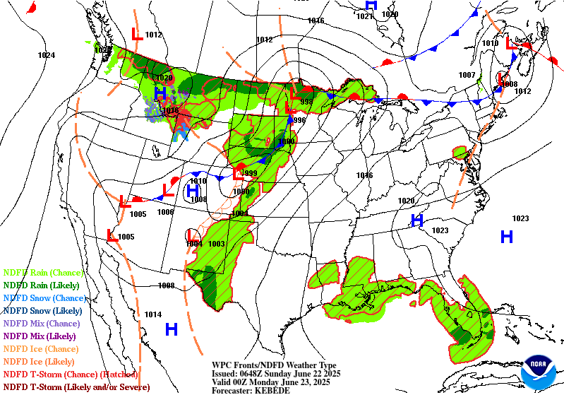
...THERE IS A SLIGHT RISK OF EXCESSIVE RAINFALL ACROSS PORTIONS OF
SOUTHEAST NEW MEXICO AND SOUTHWEST TEXAS...
...New Mexico and Texas...
Today is the beginning of what will be a multi-day period of
excessive rainfall potential over portions of west TX into NM. The
mid/upper level pattern features a near record to record ridge over
the eastern U.S. and a well-defined longwave trough over the west.
Southerly flow in between these features will supply ample
moisture to NM, with a connection all the way to the Caribbean Sea.
The better forcing from the western trough will generally hold of
until Monday and Tuesday (see the day 2 and 3 EROs), but today will
still have enough moisture and instability around for scattered
convective development. In fact PWs should already be getting
towards climatological max values for late June over portions of
southwest TX and immediate adjacent areas of NM. And while the
better forcing arrives Monday, do note broadly divergent flow at
250mb Sunday which could help sustain convection.
The greatest convective coverage is expected to be across portions
of southwest TX, where this is considered a higher end Slight
risk. Deep layer mean flow is weak, suggesting slow cell motions
today. Convection forming on/near terrain will slowly move off the
terrain, with outflows likely allowing for some cell merger
activity. Given this will be occurring within a very high PW
airmass, scattered areas of flash flooding appear likely. Both the
00z HREF and REFS indicate a high likelihood of rainfall locally
exceeding 3", with at least some potential of isolated amounts over
5". A Marginal risk extends across much of eastern NM into
adjacent area of west TX, where storm coverage should be less...but
slow moving cells will still be capable of producing localized
flash flood concerns.
...Eastern Dakotas into Minnesota...
The setup looks favorable for another round of organized
convection this afternoon and evening across the region. Strong
shortwave energy ejecting into the northern Plains, a strengthening
axis of low level moisture transport, and upwards of 4000 j/kg of
MUCAPE will drive the convective threat. The combination of extreme
instability, PWs well over the 90th percentile for late June, and
a warm front focusing convection, all point to a heavy rainfall
threat. Main uncertainty is the longevity of higher rainfall rates
and the exact axis of convection. Cells will generally be moving
along quick enough to preclude much of a flash flood threat,
however some training along the warm front over far northern MN is
possible. Activity may actually get going this morning, with some
additional development by this afternoon. Also seeing a growing
signal for convective development by this evening over southeast SD
as convergence increases along the cold front. This activity
should move northeast along the axis of the front across MN
tonight. While this activity should be quick moving, heavy
rainfall rates could still pose an isolated flash flood risk.
...Northeast...
An area of organized convection is diving southeast across
portions of NY as of 08z this morning. The evolution of this
activity after 12z this morning remains a bit unclear, however
some backbuilding/training potential may persist on the
west/southwest flank of convection. While the motion of the
complex should continue off to the southeast with the deep layer
mean flow, upwind propagation vectors are off the southwest, a
favorable sign for backbuilding. There will be plenty of upstream
instability advecting in to sustain convection...however low level
convergence should be on the decrease after 12z, and continued
warm advection aloft will increase capping. Thus the degree of
maintenance beyond 12z remains a question...but seeing enough of a
threat for at least some backbuilding/training to justify a
Marginal risk in the new day 1 ERO. PWs are certainly high enough
to support at least a localized flash flood risk with any
convection that is able to train/backbuild this morning.
Chenard
Day 1 threat area:
www.wpc.ncep.noaa.gov/qpf/94epoints.txt
Excessive Rainfall Discussion
NWS Weather Prediction Center College Park MD
430 AM EDT Sun Jun 22 2025
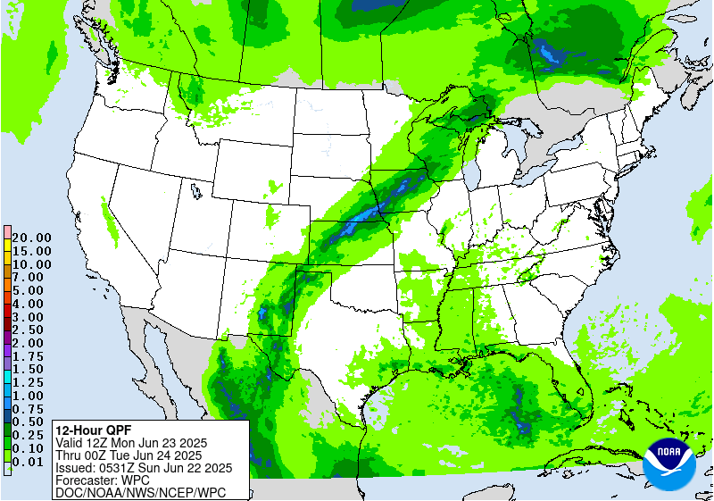
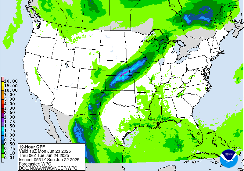
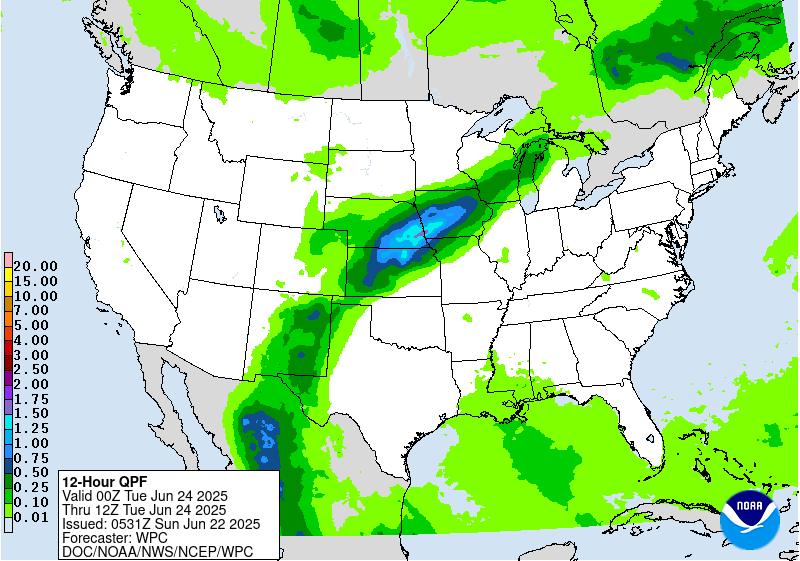
Day 2
Valid 12Z Mon Jun 23 2025 - 12Z Tue Jun 24 2025
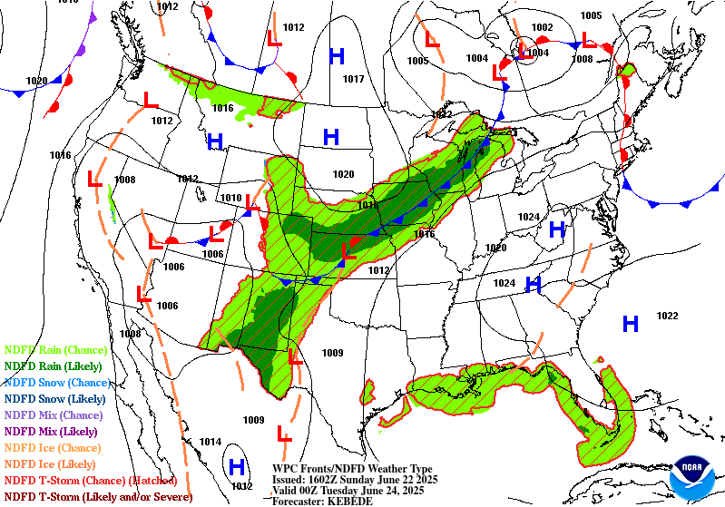
...THERE IS A SLIGHT RISK OF EXCESSIVE RAINFALL ACROSS PORTIONS OF
NEW MEXICO AND WEST TEXAS, AND FROM KANSAS INTO IOWA...
...Southwest...
The overall pattern over the Southwest described in the day 1
discussion will persist into the day 2 period. By Monday forcing,
moisture, and instability should all be on the increase across NM,
and thus expect convective coverage and flash flood risk to be on
the rise as well. The gradual approach of the west coast trough
will bring the right entrance region of the upper jet closer, and
continued moisture advection in between the trough and the east
coast ridge will push PWs well above the climatological 90th
percentile and towards late June record levels. Instability is a
bit of a question as cloud cover debris from Sundays activity could
play a role...however the model consensus is averaging 1000-2000
j/kg over much of eastern NM into far west TX. Not a ton of deep
layer flow, so convection forming on/near terrain should slowly
move off the terrain and allow for some cell merger activity. The
expected convective coverage should eventually erode instability
enough that activity trends down by overnight...but not before what
should be a more widespread scattered flash flood risk over
eastern NM and west TX where a Slight risk remains.
Far southeast NM into southwest TX looks to be a focus for more
organized slow moving convection, with the 00z RRFS, GEM Reg and
ECMWF all focusing higher totals over this area. In fact the RRFS
and Gem Reg indicate localized amounts over 3" are likely, with a
few spots over 5" possible. Another area of focus will be the
sensitive burn scar areas of the Sacramento Mountains. High res
guidance indicates a likelihood of strong convective development
over the terrain here Monday afternoon, with high rainfall rates
leading to what could be a locally significant flash flood risk.
...Central Plains to MS Valley...
A Slight risk remains from portions of central KS into southeast
NE and much of central and northern IA where convection along a
stationary front poses an isolated to scattered flash flood risk.
Model guidance indicates convective development along/near this
front Monday afternoon, with some persistence and/or upscale
development possible Monday evening as low level moisture
transport increases. Corfidi vectors over this area are divergent,
indicating a favorable environment for slow moving/backbuilding
convection near this front. PWs should be well over the 90th
percentile for late June along this front, as the same plume of
moisture over the Southwest will be in place here as well. Thus
any training of convection will pose a flash flood risk.
Maintenance of instability is probably the main question mark, as
the pool of forecast instability is not overly impressive and
neither is the magnitude of the low level jet...so the extent of
convective persistence into the overnight is a bit unclear. However
do note some upward trend in instability, so while this convection
should eventually erode the instability and weaken, we should
still be able to realize several hours of possible training
convection.
The highest probabilities of excessive rainfall are likely across
portions of north central KS into far southeast NE and far
southwest IA. It is here along the southwest flank of the
convection where we should have the strongest uptick in convergence
Monday evening, and also the better upstream instability pool. As
mentioned above, upwind propagation vectors are favorable for
backbuilding and training along this axis. Do consider this a
higher end Slight risk over this corridor, as the high PWs combined
with training convection supports a scattered flash flood risk. In
fact FFG exceedance may support MDT risk probs (40%), but given
dry antecedent soil conditions and the narrow nature of the
expected rainfall axis..will keep the risk at a higher end Slight
level for now.
Chenard
Day 2 threat area:
www.wpc.ncep.noaa.gov/qpf/98epoints.txt
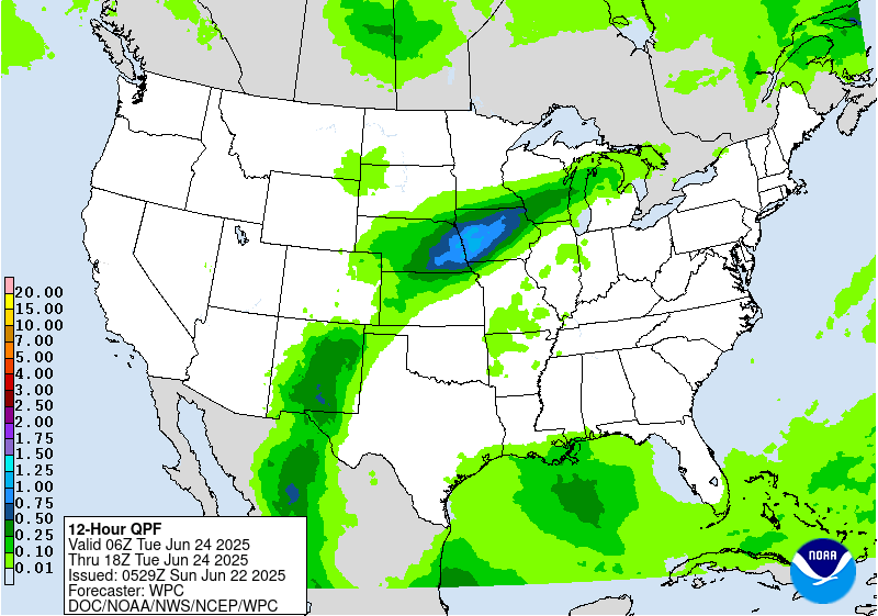
Excessive Rainfall Discussion
NWS Weather Prediction Center College Park MD
430 AM EDT Sun Jun 22 2025
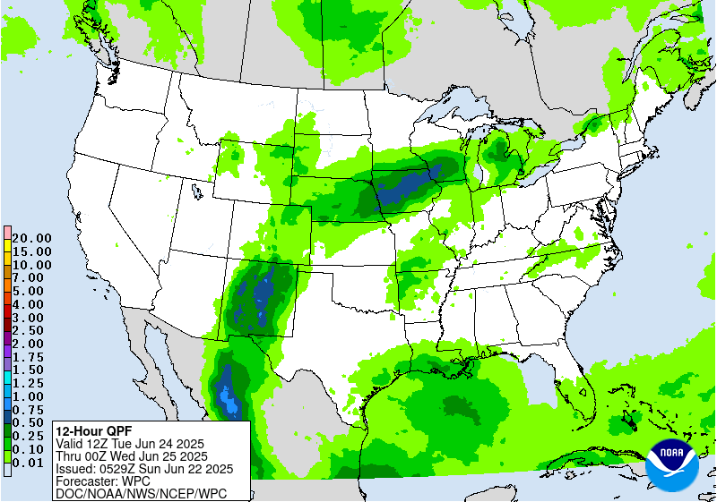
Day 3
Valid 12Z Tue Jun 24 2025 - 12Z Wed Jun 25 2025
...THERE IS A MODERATE RISK OF EXCESSIVE RAINFALL OVER PORTIONS OF
CENTRAL NEW MEXICO...
...New Mexico...
Very similar setup as was described in the day 2 discussion
continues into Tuesday. The moisture axis will shift a bit farther
west by Tuesday, and with the upper trough getting closer large
scale forcing will be slightly stronger. So should be another day
of widespread convection over NM, with deterministic and ensemble
guidance suggesting this will be the day of highest areal averaged
rainfall. Flash flooding over this part of the country is heavily
driven by rainfall rates...and whenever you see a widespread heavy
QPF signal such as this you do wonder about the degree of
instability that will be present. We have seen before where these
more widespread rainfall days end up under performing flash flood
wise, as cloud cover limits instability and keeps rainfall rates
lower. So while that is something to keep in mind...all other
factors suggest Tuesday will be a day with scattered to numerous
instances of flash flooding over NM. It seems more likely that the
modest westward shift and increase in the moisture axis/forcing
will support areas or organized heavy rainfall rates.
Central NM seems most likely to see more numerous impacts and thus
a MDT risk was maintained across this area. Some of this MDT risk
area will also have likely seen heavy rainfall Monday, thus
hydrologic conditions over some of this area will likely be more
sensitive by Tuesday, adding to the flash flood risk. This MDT
risk area includes the sensitive burn scar areas of the Sacramento
Mountains. While much of NM will see a flash flood risk Tuesday,
the MDT risk area has the greatest risk of seeing more numerous
and higher end impacts. Some rainfall totals over 3" appear
probable, and would again not be surprised to see totals locally
exceed 5" where convection persists the longest.
...NE/SD/IA and vicinity...
A broad Slight risk was maintained across portions of NE/SD east
into IA, southern MN and southern WI. Some convection will likely
be ongoing across this area Tuesday morning, although would
generally expect this to be of a weakening nature. By afternoon we
should see additional development both the near the stationary
front and over the High Plains. Convective details by this lead
time become murky, and thus confidence on the details remain low.
The ingredients (high PWs, instability, stationary front) will
remain favorable for an area of excessive rainfall...and rainfall
on preceding days may make hydrologic conditions more sensitive
over portions of this area by this time. Ensemble probabilities and
recent runs of the AIFS highlight northeast NE into northern IA as
having the greatest heavy rainfall risk, and thus this portion of
the Slight risk is considered higher end. This is where the best
chance of scattered flash flooding seems to exist, especially if
this additional rain overlaps any areas of heavy rainfall from
Monday.
Chenard
Day 3 threat area:
www.wpc.ncep.noaa.gov/qpf/99epoints.txt
Extended Forecast Discussion
NWS Weather Prediction Center College Park MD
258 AM EDT Sun Jun 22 2025
On Wednesday, the upper trough in the Interior West will be
gradually weakening, lessening upper jet right entrance region
support and slightly lessening moisture anomalies in the southern
Rockies/High Plains compared to what's now the short range period.
However, some heavy rain could still be a concern centered around
New Mexico, especially considering the wet antecedent conditions by
then. A Slight Risk is delineated in the Sacramento Mountains and
vicinity for the Day 4/Wednesday ERO, where orographic support
could enhance rainfall totals and where burn scars and steep
terrain make the area sensitive to heavy rain. Rain amounts should
continue to gradually decrease there into later week. Will show a
Marginal Risk on Day 5/Thursday for southern portions of New Mexico
including the Sacramento Mountains for another potential round of
moderate to locally heavy rain.
The plume of subtropical/tropical moisture will arc northeastward
into the north-central Plains and Upper Midwest/Corn Belt where the
additional lift around the frontal boundary and potential training
will favor areas of heavier rainfall and some flash flooding
potential. For the Day 4/Wednesday ERO, continue to show a Slight
Risk (with embedded probabilities on the higher end of the Slight
range) for these areas. The Slight generally covers some model
spread from an eastern Nebraska focus to areas farther northeast.
The details in the heavy rainfall placement remain uncertain south
due to the sensitivity to day-to-day rainfall patterns and
mesoscale boundaries. A weak surface low embedded along the front
may track somewhat east by Thursday, pushing the heaviest rain
totals across much of Wisconsin and possibly the U.P. of Michigan.
Thus for the initial Day 5/Thursday ERO, will show a Slight Risk
there, given potential for 2 to 4 inches to accumulate despite
continued spread in the exact positioning. For both Wednesday and
Thursday, some convection with locally heavy rain could traverse
the northern side of the ridge farther east into New York State and
the northern Mid-Atlantic, so will show Marginal Risks there. The
Northeast may see increasing rain amounts by Friday, while another
round of rain is possible in the north-central U.S. late week as
well.
Farther south, there is some uncertainty with how much convection
may occur under the upper ridge across the Gulf Coast and
southeastern U.S. as surface-based instability likely battles with
subsidence aloft. In general, scattered thunderstorms may increase
in coverage as the week progresses as the upper high gradually
weakens.
The strong upper high/ridge stretching across the south-central to
eastern U.S. will allow for well above average temperatures that
could approach or exceed daily records at a few dozen locations
through Wednesday, with more widespread coverage of record warm
morning lows if those numbers hold through the calendar day. This
translates into highs well into the 90s into the low 100s, with
heat indices to near 110F as dew points will be in the 60s to
low/mid-70s. Overnight lows will only drop into the low/mid 70s for
many areas, and even may stay around 80-83F in the urban centers
like Washington, D.C., Baltimore, Philadelphia, and New York City.
This will bring little relief from the heat and exacerbate
potential impacts. Thus, HeatRisk values will be Major to Extreme
for portions of the Midwest and Ohio Valley to Eastern states --
levels 3 and 4 on a scale from 1 to 4 (4 being Extreme). This
indicates an intensity and duration of heat that is extremely
dangerous to anyone without adequate cooling or hydration. Extreme
heat is the number 1 weather-related killer -- please take
precautions if you are outside during the hottest part of the day
and seek cooling if you are without adequate means. Temperatures
will remain above average, though a few degrees lower and with
fewer records possible, across much of the Ohio Valley/Mid-
Atlantic/Southeast into the latter part of next week. But the
Northeast should see moderating temperatures after a cold frontal
passage. Meanwhile, temperatures (particularly highs) are forecast
to be below average by a few degrees in the High Plains into
midweek, but the West should gradually warm to a bit above average
as the week progresses.
Tate


