


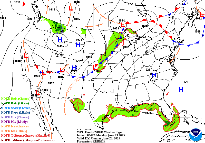
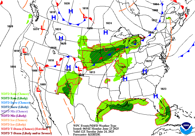
Valid Mon Jun 23, 2025
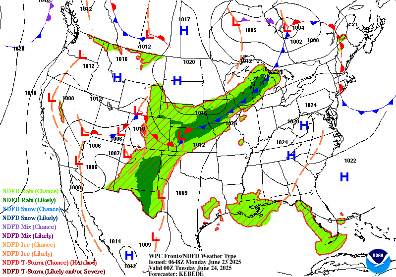
Valid Tue Jun 24, 2025
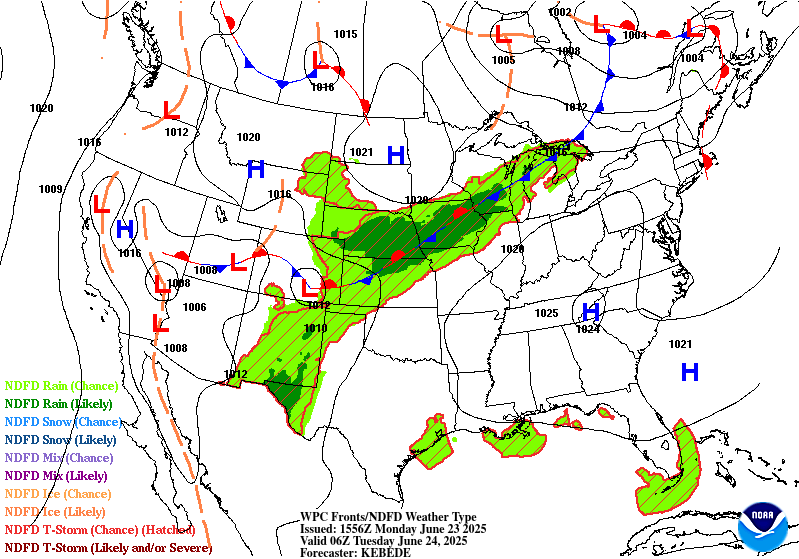
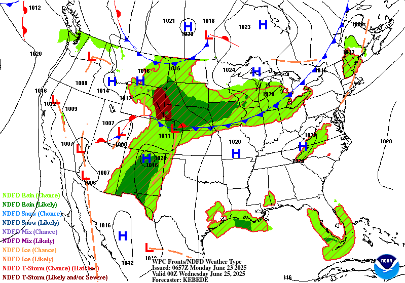
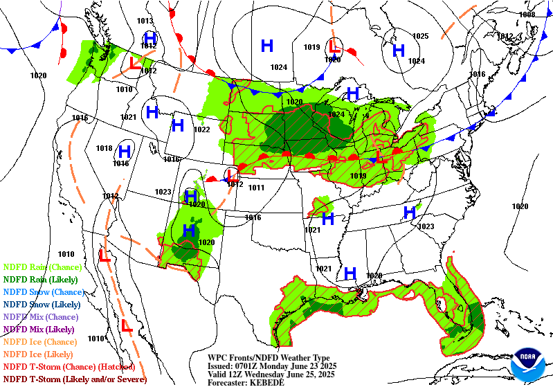
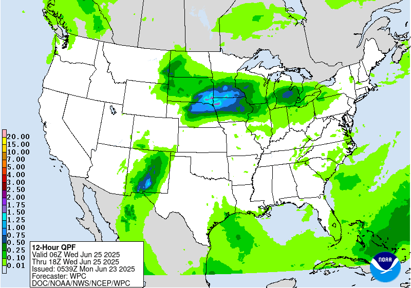
Valid Wed Jun 25, 2025


+ Additional Links
- » Description of the National Forecast Chart
- » Product Archives
- » Download hazards in KML or shapefile format or GeoJSON format


NWS Weather Prediction Center College Park MD
351 AM EDT Mon Jun 23 2025
Valid 12Z Mon Jun 23 2025 - 12Z Wed Jun 25 2025
...Extremely dangerous heat persists from Midwest to the East Coast this
week...
...Excessive Rainfall and Severe Weather concerns across portions of the
Central U.S....
A strong upper-level ridge parked over the eastern half of the country
will continue to generate an extremely dangerous heat wave this week.
Extreme HeatRisk impacts will expand from the Midwest into the
Mid-Atlantic today. This level of HeatRisk is known for being rare and/or
long duration with little to no overnight relief, and affects anyone
without effective cooling and/or adequate hydration. High temperatures in
the 90s to 100s and lows in the 70s to low 80s will break numerous records
over the next several days. Dense urban centers like: Columbus, OH;
Washington, DC; and Philadelphia, PA will experience especially
significant heat impacts. Heat related illnesses increase significantly
during extreme heat. Wear lightweight and loose fitting clothing. Take
action when you see symptoms of heat exhaustion and heat stroke.
Elsewhere, a slow moving upper trough and quasi-stationary surface fronts
will produce rounds of thunderstorms across the Central U.S. over the next
few days. SPC issued a slight risk (level 2/5) of severe thunderstorms for
a swath extending from northern Kansas to northern Michigan/the U.P. today
followed by another slight risk over the Front Range on Tuesday. Wind
gusts and hail will be the primary threats for both areas, while a tornado
or two could materialize over the Front Range on Tuesday. There will also
be excessive rainfall/flash flooding concerns along the front draped
across the Central Plains/Upper Midwest. A slight risk (at least 15%) of
excessive rainfall is in effect for parts of central Kansas to
southwestern Wisconsin today followed by another one over parts of
southeastern South Dakota, eastern Nebraska, northeastern Kansas, northern
Missouri, Iowa, southern Wisconsin, northern Illinois and southern
Minnesota on Tuesday.
Anomalous moisture over the Southern High Plains will likely interact with
a surface trough/dryline and produce scattered to isolated storms over the
next few days. There's a slight risk of excessive rainfall over parts of
eastern New Mexico and western Texas where a couple inches of rain could
fall. Conditions worsen while moisture anomalies increase and shift
westward a bit on Tuesday. Afternoon/evening storms could produce several
inches of rain over much of New Mexico and into southern Colorado. A
moderate risk (at least 40%) of excessive rainfall leading to flash
flooding over parts of central New Mexico, where some overlap in heavy
rainfall from the previous day may occur. Burn scar areas within the
Sacramento Mountains are at particular risk of flash flooding. Meanwhile,
temperatures remain below average in the West beneath an amplified upper
trough. Temps begin to rebound on Tuesday.
Kebede
Graphics available at
https://www.wpc.ncep.noaa.gov/basicwx/basicwx_ndfd.php
NWS Weather Prediction Center College Park MD
259 AM EDT Mon Jun 23 2025
Valid 12Z Thu Jun 26 2025 - 12Z Mon Jun 30 2025
...Record heat is less likely by later week, but dangerous heat
continues for the Ohio/Tennessee Valleys and
Mid-Atlantic/Southeast...
...Heavy rain and flash flooding possible in the Upper
Midwest/Great Lakes late week...
...Overview...
Into the latter part of the the week, the peak of the significant
and extremely dangerous heat wave will have waned. However,
temperatures will remain quite hot across the Ohio and Tennessee
Valleys into the Mid-Atlantic and Southeast, and the long duration
of the heat wave could cause exacerbated impacts, maintaining Major
to Extreme HeatRisk in some areas into late week.
Tropical/subtropical
moisture will advect north across New Mexico and then east around
the southeastern U.S. upper ridge in a "ring of fire" setup. The
moisture should interact with a wavy frontal boundary and promote
potentially heavy rain and flash flooding in the Midwest and Great
Lakes regions late week. Additional rounds of scattered
thunderstorms are possible across much of the central and eastern
U.S. into the weekend.
...Guidance/Predictability Assessment...
Model agreement is rather good at the start of the medium range
period, with guidance showing for multiple days that the upper high
will be weakening by Thursday. A trough across the interior West
will also be decaying at that point, while models are now showing
an upper low coming across Florida while weakening as well. Overall
the pattern will become more zonal by late week into the weekend.
This is shown well by the models, but as a result shortwaves are
the primary driver of sensible weather like frontal positions, and
these smaller scale features are more uncertain. The first
shortwave in a northern stream wave train will cross the Great
Lakes/southern Canada Thursday-Friday and support a surface
low/frontal system and the potentially heavy QPF. There is some
spread in the depth and timing of this shortwave and thus the
surface features. The 18Z GFS was unfavorable with a stronger
surface low farther north of the better consensus. Behind this a
broader, but not very amplified, trough is forecast to move through
the Northwest Friday and continue across the north-central U.S.
over the weekend and the Great Lakes by next Monday. The 12Z GFS
was on the slower side with this trough, but other models lined up
well. There is good agreement for a ridge behind that trough, and
then will monitor a northeast Pacific upper low to potentially
impact the pattern early next week, while some weak southern stream
troughing sets up near the West Coast.
The WPC forecast was based on a multi-model blend early in the
medium range, and introduced and gradually increased the GEFS and
EC ensemble means to half by Day 7 to lessen the influence of
individual model variability.
...Weather/Hazards Highlights...
On Thursday, some anomalously high tropical/subtropical moisture
should still be filtering into New Mexico. However, with the upper
trough in the Interior West weakening, there will be less upper
level support for widespread convection compared to the short range
period. Regardless, heavy rain could still be a concern in New
Mexico, especially considering the wet antecedent conditions by
then. Will maintain Marginal Risks in the Days 4/5
(Thursday/Friday) EROs with a particular focus on the Sacramento
Mountains, where orographic support could enhance rainfall totals
and where burn scars and steep terrain make the area sensitive to
heavy rain. Some showers and storms are possible there into the
weekend.
The plume of moisture will arc northeastward into the Upper
Midwest/Great Lakes region, where the additional lift around a weak
surface low and frontal boundary in the vicinity and potential
training will favor areas of heavier rainfall and some flash
flooding potential. For the Day 4/Thursday ERO, continue to show a
Slight Risk across the Upper Midwest/much of Wisconsin and the U.P.
of Michigan, given potential for 2 to 4 inches to accumulate
despite continued spread in the exact positioning. Some convection
with locally heavy rain could traverse the northern side of the
ridge farther east into New York State and the northern Mid-
Atlantic, and have captured these areas within the Marginal Risk on
Thursday. By Friday the surface low/frontal system will continue
to track east, bringing some potentially enhanced rain amounts to
the Lower Great Lakes region and Interior Northeast. There is some
spread in the models' positioning of the heaviest QPF, including
some models showing the heaviest rain staying in Canada, so will
start with a Marginal Risk in the Day 5/Friday ERO rather than
showing a Slight Risk at this point. But will continue to monitor
trends especially because some areas like the terrain there can be
sensitive to heavy rainfall. Meanwhile, another shortwave may move
through the north-central U.S. while instability is likely to be
high (MUCAPE of 3000-5000 J/kg already shown by the global models).
Have a Marginal Risk delineated in parts of the Dakotas to
Minnesota since locally heavy rain rates are likely in this
unstable atmosphere.
Scattered showers and thunderstorms will become more widespread
across much of the eastern third of the country through the period.
A weak upper low may track across Florida and vicinity on
Thursday- Friday and provide additional support for convection.
Plan to wait and see if model agreement gets better for heavy
amounts and their placement before showing any ERO risks. Scattered
convection is also likely across the Appalachians and into the
Eastern Seaboard each day as the heat creates an unstable airmass.
The strong upper high/ridge stretching across the south-central to
eastern U.S. will weaken somewhat into late week, but remain
generally in place, maintaining hot temperatures albeit slightly
moderated from the short range period and less likely to break
records. Nevertheless, temperatures will be well into the 90s in
many central and eastern areas, while dewpoints in the 70s will
raise heat indices into the 100s. Overnight lows will only drop
into the low/mid 70s for many areas, bringing little relief from
the heat and exacerbating potential impacts. Especially after the
extreme heat in the short range, through late week HeatRisk values
will be Major to Extreme for portions of the Midwest and Ohio
Valley to Eastern states -- levels 3 and 4 on a scale from 1 to 4
(4 being Extreme). This indicates an intensity and duration of heat
that is extremely dangerous to anyone without adequate cooling or
hydration. Extreme heat is the number 1 weather-related killer --
please take precautions if you are outside during the hottest part
of the day and seek cooling if you are without adequate means.
Temperatures may continue to slowly moderate into the weekend for
closer to normal summer heat. Elsewhere, the Northeast should see
relief from the heat by the medium range period behind a backdoor
front. The north-central U.S. can expect warmer than average
temperatures by 5 to 10 degrees around Friday-Saturday and then
cool behind a cold front. Temperatures in the Northwest will warm
by early next week under an upper ridge. The Desert Southwest can
expect typical summer heat with temperatures in the 100s and 110s.
Tate
Additional 3-7 Day Hazard information can be found on the WPC
medium range hazards outlook chart at:
https://www.wpc.ncep.noaa.gov/threats/threats.php
WPC medium range 500mb heights, surface systems, weather grids,
quantitative precipitation forecast (QPF), excessive rainfall
outlook (ERO), winter weather outlook (WWO) probabilities, heat
indices, and Key Messages can be accessed from:
https://www.wpc.ncep.noaa.gov/medr/5dayfcst500_wbg.gif
https://www.wpc.ncep.noaa.gov/medr/5dayfcst_wbg_conus.gif
https://www.wpc.ncep.noaa.gov/5km_grids/5km_gridsbody.html
https://www.wpc.ncep.noaa.gov/qpf/day4-7.shtml
https://www.wpc.ncep.noaa.gov/#page=ero
https://www.wpc.ncep.noaa.gov/wwd/pwpf_d47/pwpf_medr.php?day=4
https://www.wpc.ncep.noaa.gov/heat_index.shtml
https://www.wpc.ncep.noaa.gov/#page=ovw
Hawaii Extended Forecast Discussion
NWS Weather Prediction Center College Park MD
345 AM EDT Mon Jun 23 2025
Valid 00Z Tue 24 Jun 2025 - 00Z Tue 01 Jul 2025
Easterly trade winds will be breezy on Monday under the influence
of a tight pressure gradient from a surface high centered
northeast of Hawaii. This high will weaken gradually and winds
should return to moderate to locally breezy levels by midweek and
continue through late week and the weekend. Meanwhile aloft, a
weak upper trough will retrograde across the state and may allow
for a raised inversion while waves of higher moisture move
through. This should lead to a comparatively wetter trade wind
pattern through much of the week, especially for Kauai and
vicinity where enhanced moisture lingers the longest. By the
weekend a mid/upper high may sneak into at least the eastern
islands and suppress some potential showers.
Tate


» Extreme Precipitation Monitor
+ Additional Links
- » Product Verification
- » Product Archive
- » Product Info
- » Additional formats of QPF: GRIB 2 | Shapefiles | KML
- » Other QPF Products


+ Forecast Discussion
Excessive Rainfall Discussion
NWS Weather Prediction Center College Park MD
850 PM EDT Sun Jun 22 2025
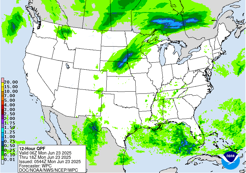
Day 1
Valid 01Z Mon Jun 23 2025 - 12Z Mon Jun 23 2025
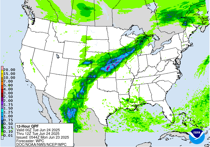
...THERE IS A SLIGHT RISK OF EXCESSIVE RAINFALL ACROSS PORTIONS OF
SOUTHEAST NEW MEXICO AND WEST TEXAS...
01Z Update...
Although an isolated storm cannot be ruled out, the environment
will continue to remain unfavorable for widespread storm
redevelopment overnight across the Northeast. Therefore, the
Marginal and Slight Risk areas were removed from region.
Elsewhere, based on current observation trends and recent hi-res
guidance, minor adjustments were made to the previous outlook
areas over the central U.S. Recent runs of the HRRR and the 18Z
HREF continue to show a notable signal for heavy amounts and
potential flash flooding centered over West Texas to the New Mexico
border, with the heaviest amounts centered from the western Big
Bend Region into the Davis Mountains. HREF neighborhood
probabilities indicate that localized amounts over 2 inches are
likely in this area.
Pereira
16Z Excessive Rainfall Discussion...
New Mexico and Texas...
12Z upper air showed precipitable water values in excess of 2
inches continued to be drawn northward into West Texas...on par
with the 2 to 3 standardized anomaly precipitable water forecast
from the overnight numerical guidance. With the large scale forcing
largely in place...there were few changes needed here.
The Dakotas/Nebraska to Minnesota...
Made a few adjustments to the northern portion of the Marginal Risk
area given convective behavior earlier this morning...while a
southward expansion into northern Nebraska was based largely on a
consistent signal for convective development during the afternoon
farther south and west than indicated by the 00Z/06Z numerical guidance.
This area of convection looks to be progressive...but locally
intense rates are possible given the precipitable water values
which exceed 1.75 inches by early evening.
Bann
...New Mexico and Texas...
Today is the beginning of what will be a multi-day period of
excessive rainfall potential over portions of west TX into NM. The
mid/upper level pattern features a near record to record ridge over
the eastern U.S. and a well-defined longwave trough over the west.
Southerly flow in between these features will supply ample
moisture to NM, with a connection all the way to the Caribbean Sea.
The better forcing from the western trough will generally hold of
until Monday and Tuesday (see the day 2 and 3 EROs), but today will
still have enough moisture and instability around for scattered
convective development. In fact PWs should already be getting
towards climatological max values for late June over portions of
southwest TX and immediate adjacent areas of NM. And while the
better forcing arrives Monday, do note broadly divergent flow at
250mb Sunday which could help sustain convection.
The greatest convective coverage is expected to be across portions
of southwest TX, where this is considered a higher end Slight
risk. Deep layer mean flow is weak, suggesting slow cell motions
today. Convection forming on/near terrain will slowly move off the
terrain, with outflows likely allowing for some cell merger
activity. Given this will be occurring within a very high PW
airmass, scattered areas of flash flooding appear likely. Both the
00z HREF and REFS indicate a high likelihood of rainfall locally
exceeding 3", with at least some potential of isolated amounts
over 5". A Marginal risk extends across much of eastern NM into
adjacent area of west TX, where storm coverage should be less...but
slow moving cells will still be capable of producing localized
flash flood concerns.
...Eastern Dakotas into Minnesota...
The setup looks favorable for another round of organized
convection this afternoon and evening across the region. Strong
shortwave energy ejecting into the northern Plains, a strengthening
axis of low level moisture transport, and upwards of 4000 j/kg of
MUCAPE will drive the convective threat. The combination of extreme
instability, PWs well over the 90th percentile for late June, and
a warm front focusing convection, all point to a heavy rainfall
threat. Main uncertainty is the longevity of higher rainfall rates
and the exact axis of convection. Cells will generally be moving
along quick enough to preclude much of a flash flood threat,
however some training along the warm front over far northern MN is
possible. Activity may actually get going this morning, with some
additional development by this afternoon. Also seeing a growing
signal for convective development by this evening over southeast SD
as convergence increases along the cold front. This activity
should move northeast along the axis of the front across MN
tonight. While this activity should be quick moving, heavy
rainfall rates could still pose an isolated flash flood risk.
Chenard
Day 1 threat area: www.wpc.ncep.noaa.gov/qpf/94epoints.txt
Excessive Rainfall Discussion
NWS Weather Prediction Center College Park MD
404 AM EDT Mon Jun 23 2025
Day 1
Valid 12Z Mon Jun 23 2025 - 12Z Tue Jun 24 2025
...THERE IS A SLIGHT RISK OF EXCESSIVE RAINFALL ACROSS PORTIONS OF
NEW MEXICO AND WEST TEXAS, AND FROM KANSAS INTO SOUTHWEST WISCONSIN...
...New Mexico into West Texas...
A general pattern of persistence will maintain a relevant posture
for scattered to widespread convective impacts across Southwestern
TX up through the eastern half of NM with the highest potential
impacts aligned within the terrain. Ample moisture advection
provided by prevailing southerly-oriented flow within the sfc-500mb
layer will correlate with an environment capable of locally heavy
rainfall within any cell maturation across the above areas. The
proxy of the deep layer moisture and RER jet dynamics from the mean
trough situated to the west will create an accumulated risk of
showers and storms propagating over the same areas leading to
increasingly compromised soils, or even interacting with the
already prevalent burn scars situated over the Sacramento Mtns.
Storm motions will likely be fairly weak as noted by the forecast
Corfidi vectors residing between 5-15kts on average within the
confines of the entire Southwest TX and Southeast NM domains. This
will allow for modest training concerns that will ultimately cause
problems if they fall within any of the urban centers along the
Upper Trans Pecos out into the complex topography located in the
region. The best chance for flash flooding will likely be within
those burn scar locations where hydrophobic soils are still a
problem and can promote a formidable runoff regime that could cause
significant problems locally if a heavy cell forms overhead. Areas
within the Pecos river are also notorious for flash flooding
capabilities due to the limited drainage structures prevalent
within town limits. Considering the HREF neighborhood probs for >2"
are running between 50-90% over a large area extending from the
Davis Mtns up through the Eastern NM Caprock, the previous SLGT
risk was upheld with wording of a higher end SLGT considering the
environment in place.
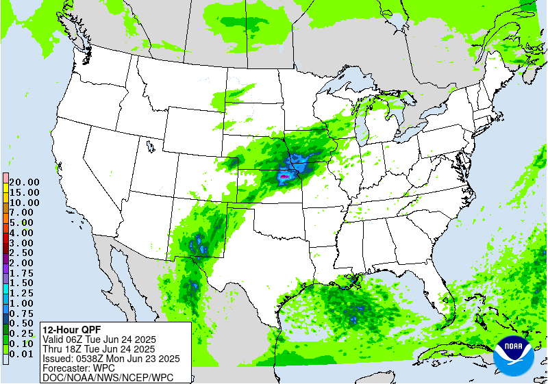
...Central Plains to Midwest...
The Central Plains through the Midwest continues to lie within the
northern and northwest periphery of a broad ridge extension
centered over the Mid Atlantic. The proxy of the ridge has allowed
for a persistent south to southwesterly mean flow within the
column leading to steady moisture advection within the boundary
layer up to around 500mb. Current PWATs from 00z RAOB analysis
across the Plains and Mississippi Valley denote moisture anomalies
that are approaching +2 deviations, something that has also been
reflected in the last several days of NAEFS anomalies within the
ensemble suite. The relevant moisture pooling across the zone
extending from KS up into the Midwest will lead to a formidable
widespread convective initiation scheme that will develop due to
increased convergence along and ahead of a slow-moving cold front
nosing down through the Northern Plains. The interaction of the
cold front with a very buoyant environment (MUCAPE 2500-4000 J/kg)
located across the Central Plains up into the Upper Mississippi
Valley will create a broad axis of heavy convection with the
heaviest precip likely correlated with the 2+" PWAT domain located
from North-Central KS and points northeast into IA.
There's a general consensus within the latest CAMs suite of
significant totals between 2-4" forecast located within the
aforementioned zone, including some deterministic output and lower
neighborhood prob correlation for some places exceeding 5". The
prospects for those types of totals stems from not only the
favorable deep moist convective pattern, but also the mean layer
flow and surface convergence regime along the front creating a
favorable environment for back-building convection and training
cell prospects. This is fairly well-documented when assessing
forecast Corfidi Vectors continuing this divergent storm motion
setup within the upshear and downshear calculations given the
forecast wind field(s). A strong RER jet dynamic will only aid in
a blossoming QPF field and maintenance as the mean flow takes the
convective pattern off to the northeast. This pattern will carry
through Monday evening into early Tuesday morning with some
weakening of the convective field anticipated due to loss of
diurnal destabilization. In any case, this setup is capable of
widespread 1-2" totals with the hardest hit locations likely seeing
2-4" with locally higher as noted in the latest CAMs. The saving
grace, at least initially for D1, are the drier soils centered over
the Central Plains into parts of Southeast NE and Southwest IA
leading to higher FFG indices that will need some priming in order
to likely reflect a more significant flash flood response.
The change from the previous forecast was an adjustment to the
south with the overall SLGT risk as guidance reflects a bit of a
faster frontal progression than anticipated. This places a higher
risk a bit south over Northeast KS to points northeast. The threat
for locally heavy rainfall is also forecast across Southwest KS
with cells ejecting out of the High Plains of CO/NM, but CAMs are
less defined due to the lack of a boundary layer focus
comparatively. The MRGL exists in at particular area, but if CAMs
come into agreement on a local max centered near or southwest of
DDC, then the SLGT risk may be extended further to the southwest to
account for the prospect.
Kleebauer
Day 1 threat area: www.wpc.ncep.noaa.gov/qpf/94epoints.txt
Excessive Rainfall Discussion
NWS Weather Prediction Center College Park MD
404 AM EDT Mon Jun 23 2025
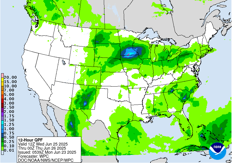
Day 2
Valid 12Z Tue Jun 24 2025 - 12Z Wed Jun 25 2025
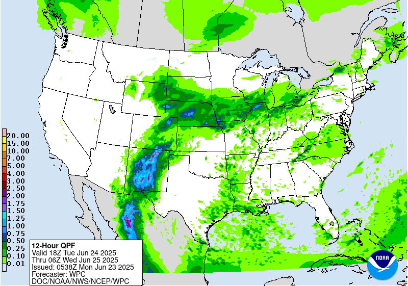
...THERE IS A MODERATE RISK OF EXCESSIVE RAINFALL OVER PORTIONS OF
CENTRAL NEW MEXICO...
...New Mexico...
Upper level pattern will be in a short transitory phase, but one
that will ultimately lead to a threat of prolonged heavy rainfall
from training convection across much of the terrain in Southern and
Central NM. The massive ridge to the east will flex further as we
head into Tuesday with the higher heights on the western fringes
pushing back west beyond the eastern portions NM. A steady north-
south progression within the mid and upper levels will send
numerous smaller shortwave perturbations poleward with anticipated
motions into the Sacramento's, eventually north into the Sangre de
Cristos by the late-afternoon and evening period on Tuesday.
Moisture remaining parked over the region coupled with the focused
ascent and narrow upslope proxy within the Sacramento Mtns. will
lead to a corridor of heavy convection remaining situated in-of
the terrain. There's a growing consensus within all deterministic
that local topographic effects within this pattern will yield some
significant rainfall potential over areas that are prone to flash
flooding, especially with the burn scars still present near Ruidoso
creating higher runoff capabilities. 00z HREF depicted between 2-3"
of rainfall in just the 12-hr period between 12-00z on Tue/Wed with
precip continuing at the end of the run. Ensemble mean forecast
within the NWP suite was up around 3" for multiple locations with a
large areal coverage of at least 2" within the mean output. These
are generally signals that favor not only flash flooding prospects,
but widespread flash flood concerns with more significant impacts
possible.
The signal for heavy rainfall continues all the way up into the
Sangre de Cristos where the afternoon and evening time frames call
for widespread heavy thunderstorm activity aligned with the ridges
of the southern Rockies. These areas also have burn scar prevalence
that could exacerbate flash flood risks as runoff capabilities are
maximized. Considering the anticipated threat bleeding further
north within the guidance this evening, the previous MDT risk was
expanded northward to encompass those areas within the Sangre de
Cristos and neighboring valleys. The threat for a targeted higher
risk over the Sacramento's is plausible if this signal remains for
another forecast cycle or two. As of now, it is deemed closer to a
high-end MDT risk with the area across the northern Sacramento's
the most susceptible to significant impact potential.
...Central Plains to Midwest...
The pattern across the Plains and Midwest that will bring heavy
rainfall to those areas Monday night into Tuesday morning will
bleed over into the D2 period with ongoing precip likely across
Northeast KS into adjacent areas of NE/MO/IA. Flash flooding
concerns will be ongoing at this time and recent CAMs output is
signaling more rainfall through at least 18z will continue to
plague those same areas. 00z HREF neighborhood probs over the 12hr
period between 12-00z Tue/Wed denote a 40-60% chance of exceeding
2" over areas that will have already seen significant (2-4+")
rainfall the period prior. Rates ~1"/hr are modest within the hi-
res ensemble probability fields as well, a testament to the
persistence in the heavy convective setup in place. There will
finally be less of a concern late in the afternoon as the frontal
progression migrates north the second half of the period, so the
threat will likely be more focused in that area the first half of
the forecast. Still, this is enough for a continued SLGT risk with
higher end risk potential given the period overlap.
The setup the following evening becomes trickier as the entire
evolution comes down to the handling of the mid-level energy riding
northeast out of the Southern Plains into the Central Plains and
Upper Midwest after nightfall. Surface front from the prior period
will eventually hit a roadblock on its southern progression and
flip back to a warm front as it migrates back to the north under
the guide of a potent LLJ generation across the Plains. The
interaction between the front and the energy will create a
secondary convective enhancement that will impact areas further
north than the previous 36 hrs. The lack of overlap may inhibit
significant impacts, however the training threat within the
confines of the boundary may be enough to warrant some higher risk
of flash flooding. The setup is depicted by guidance in the 00-12z
period Wednesday, but position of the heaviest precip is seemingly
all over the place. The threat is certainly there for 2-4" with
locally higher, but specifics still remain sort of muddled. The
SLGT risk prior was adjusted to reflect the ensemble mean QPF
distribution with a heavy precip footprint still located over far
Southeast SD into Southern MN for the period. How far north the
front migrates and handling of the shortwave ejection will
determine exactly where the heaviest precip will occur. Right now,
anywhere within the SLGT risk is fair game, so it's a time frame to
monitor closely.
Kleebauer
Day 2 threat area: www.wpc.ncep.noaa.gov/qpf/98epoints.txt
Excessive Rainfall Discussion
NWS Weather Prediction Center College Park MD
404 AM EDT Mon Jun 23 2025
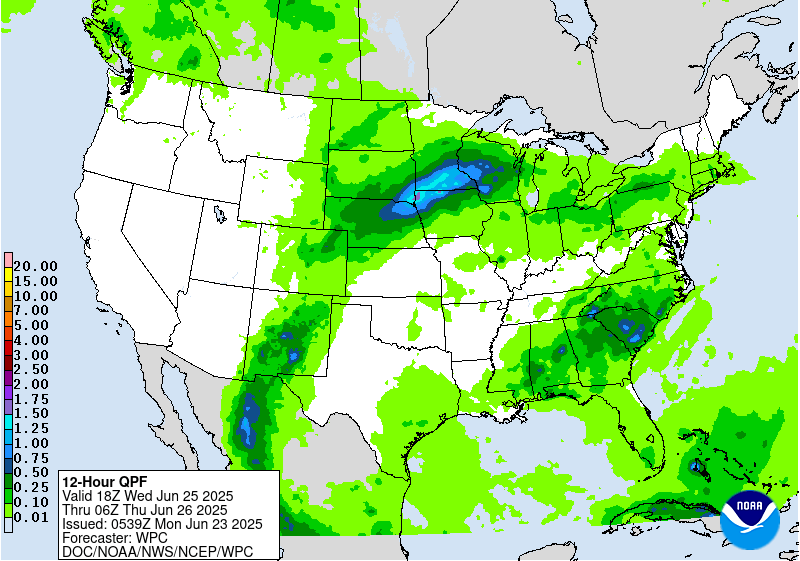
Day 3
Valid 12Z Wed Jun 25 2025 - 12Z Thu Jun 26 2025
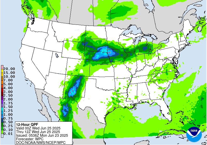
...THERE IS A SLIGHT RISK OF EXCESSIVE RAINFALL OVER PORTIONS OF
NEW MEXICO, CENTRAL PLAINS AND MIDWEST...
...New Mexico...
Unlike the prior periods, the D3 is finally the downward trend to
the incessant nature of scattered to numerous thunderstorms that
will plague the state, especially across the Sacramento's and
Sangre de Cristos. Despite the lower coverage anticipated,
scattered thunderstorms are still plausible in the afternoon as
ample heating during prime destabilization window (16-21z) will
yield another threat of thunderstorms across the terrain and
adjacent valleys. Current signals are nowhere near as robust as the
D1/D2 time frames, but with potentially significant impacts prior,
there's a greater threat of truly compromised FFG's leading in
allowing for the bar to be very low for flash flooding. As of now,
the ensemble mean is still highlighting the Sacramento's up into
the I-40 corridor as the main areas of concern. A SLGT risk was
maintained and expanded a bit to encompass the zones of greatest
risk for flash flooding. A targeted higher risk is not out of the
question for the Sacramento's, but will assess in later forecasts
as we monitor how everything evolves leading into the D3.
...Central Plains to Midwest...
Unlike the prior period where there is some uncertainty in the
handling of shortwave energy and frontal positioning, there's a
pretty good consensus brewing on the pattern converging in-of the
Upper Midwest with sights on MN into Western WI as the evolution in
D2 carries over into D3. Mean QPF output via ensembles is running
between 2-4" for an areal average with the maxima positioned across
Southern MN back into adjacent areas of SD/NE to the southwest. Not
one, but two waves of convection will encroach the area with some
spots potentially seeing some significant rainfall (>2") in both
waves which will likely lead to scattered, bordering widespread
flash flood prospects due to the compounding rainfall forecast. NBM
90th percentile QPF is well over 2" across much of the
aforementioned region with some higher totals even extending back
through NE. As of now, it's still a bit early for the higher risks
due to some uncertainty the day prior which could shift the
forecast a bit in either direction (north or south). For now,
maintained a higher end SLGT across a large portion of the Upper
Midwest with the eastern extension pushing all the way out into
Northern WI. A targeted higher risk is certainly in the cards if
this signal remains and consensus grows on the evolution of the
synoptic details.
Kleebauer
Day 3 threat area: www.wpc.ncep.noaa.gov/qpf/99epoints.txt
NWS Weather Prediction Center College Park MD
259 AM EDT Mon Jun 23 2025
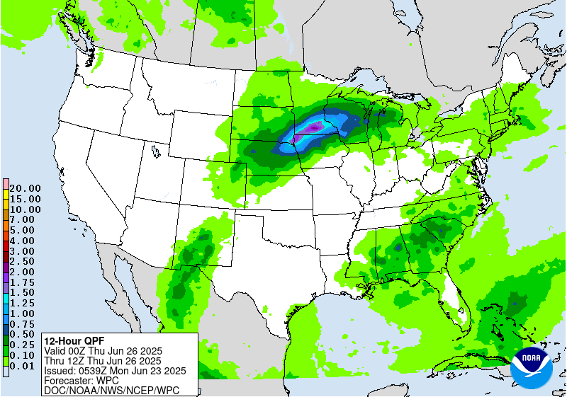
On Thursday, some anomalously high tropical/subtropical moisture
should still be filtering into New Mexico. However, with the upper
trough in the Interior West weakening, there will be less upper
level support for widespread convection compared to the short range
period. Regardless, heavy rain could still be a concern in New
Mexico, especially considering the wet antecedent conditions by
then. Will maintain Marginal Risks in the Days 4/5
(Thursday/Friday) EROs with a particular focus on the Sacramento
Mountains, where orographic support could enhance rainfall totals
and where burn scars and steep terrain make the area sensitive to
heavy rain. Some showers and storms are possible there into the
weekend.
The plume of moisture will arc northeastward into the Upper
Midwest/Great Lakes region, where the additional lift around a weak
surface low and frontal boundary in the vicinity and potential
training will favor areas of heavier rainfall and some flash
flooding potential. For the Day 4/Thursday ERO, continue to show a
Slight Risk across the Upper Midwest/much of Wisconsin and the U.P.
of Michigan, given potential for 2 to 4 inches to accumulate
despite continued spread in the exact positioning. Some convection
with locally heavy rain could traverse the northern side of the
ridge farther east into New York State and the northern Mid-
Atlantic, and have captured these areas within the Marginal Risk on
Thursday. By Friday the surface low/frontal system will continue
to track east, bringing some potentially enhanced rain amounts to
the Lower Great Lakes region and Interior Northeast. There is some
spread in the models' positioning of the heaviest QPF, including
some models showing the heaviest rain staying in Canada, so will
start with a Marginal Risk in the Day 5/Friday ERO rather than
showing a Slight Risk at this point. But will continue to monitor
trends especially because some areas like the terrain there can be
sensitive to heavy rainfall. Meanwhile, another shortwave may move
through the north-central U.S. while instability is likely to be
high (MUCAPE of 3000-5000 J/kg already shown by the global models).
Have a Marginal Risk delineated in parts of the Dakotas to
Minnesota since locally heavy rain rates are likely in this
unstable atmosphere.
Scattered showers and thunderstorms will become more widespread
across much of the eastern third of the country through the period.
A weak upper low may track across Florida and vicinity on
Thursday- Friday and provide additional support for convection.
Plan to wait and see if model agreement gets better for heavy
amounts and their placement before showing any ERO risks. Scattered
convection is also likely across the Appalachians and into the
Eastern Seaboard each day as the heat creates an unstable airmass.
The strong upper high/ridge stretching across the south-central to
eastern U.S. will weaken somewhat into late week, but remain
generally in place, maintaining hot temperatures albeit slightly
moderated from the short range period and less likely to break
records. Nevertheless, temperatures will be well into the 90s in
many central and eastern areas, while dewpoints in the 70s will
raise heat indices into the 100s. Overnight lows will only drop
into the low/mid 70s for many areas, bringing little relief from
the heat and exacerbating potential impacts. Especially after the
extreme heat in the short range, through late week HeatRisk values
will be Major to Extreme for portions of the Midwest and Ohio
Valley to Eastern states -- levels 3 and 4 on a scale from 1 to 4
(4 being Extreme). This indicates an intensity and duration of heat
that is extremely dangerous to anyone without adequate cooling or
hydration. Extreme heat is the number 1 weather-related killer --
please take precautions if you are outside during the hottest part
of the day and seek cooling if you are without adequate means.
Temperatures may continue to slowly moderate into the weekend for
closer to normal summer heat. Elsewhere, the Northeast should see
relief from the heat by the medium range period behind a backdoor
front. The north-central U.S. can expect warmer than average
temperatures by 5 to 10 degrees around Friday-Saturday and then
cool behind a cold front. Temperatures in the Northwest will warm
by early next week under an upper ridge. The Desert Southwest can
expect typical summer heat with temperatures in the 100s and 110s.
Tate
NWS Weather Prediction Center College Park MD
259 AM EDT Mon Jun 23 2025
On Thursday, some anomalously high tropical/subtropical moisture
should still be filtering into New Mexico. However, with the upper
trough in the Interior West weakening, there will be less upper
level support for widespread convection compared to the short range
period. Regardless, heavy rain could still be a concern in New
Mexico, especially considering the wet antecedent conditions by
then. Will maintain Marginal Risks in the Days 4/5
(Thursday/Friday) EROs with a particular focus on the Sacramento
Mountains, where orographic support could enhance rainfall totals
and where burn scars and steep terrain make the area sensitive to
heavy rain. Some showers and storms are possible there into the
weekend.
The plume of moisture will arc northeastward into the Upper
Midwest/Great Lakes region, where the additional lift around a weak
surface low and frontal boundary in the vicinity and potential
training will favor areas of heavier rainfall and some flash
flooding potential. For the Day 4/Thursday ERO, continue to show a
Slight Risk across the Upper Midwest/much of Wisconsin and the U.P.
of Michigan, given potential for 2 to 4 inches to accumulate
despite continued spread in the exact positioning. Some convection
with locally heavy rain could traverse the northern side of the
ridge farther east into New York State and the northern Mid-
Atlantic, and have captured these areas within the Marginal Risk on
Thursday. By Friday the surface low/frontal system will continue
to track east, bringing some potentially enhanced rain amounts to
the Lower Great Lakes region and Interior Northeast. There is some
spread in the models' positioning of the heaviest QPF, including
some models showing the heaviest rain staying in Canada, so will
start with a Marginal Risk in the Day 5/Friday ERO rather than
showing a Slight Risk at this point. But will continue to monitor
trends especially because some areas like the terrain there can be
sensitive to heavy rainfall. Meanwhile, another shortwave may move
through the north-central U.S. while instability is likely to be
high (MUCAPE of 3000-5000 J/kg already shown by the global models).
Have a Marginal Risk delineated in parts of the Dakotas to
Minnesota since locally heavy rain rates are likely in this
unstable atmosphere.
Scattered showers and thunderstorms will become more widespread
across much of the eastern third of the country through the period.
A weak upper low may track across Florida and vicinity on
Thursday- Friday and provide additional support for convection.
Plan to wait and see if model agreement gets better for heavy
amounts and their placement before showing any ERO risks. Scattered
convection is also likely across the Appalachians and into the
Eastern Seaboard each day as the heat creates an unstable airmass.
The strong upper high/ridge stretching across the south-central to
eastern U.S. will weaken somewhat into late week, but remain
generally in place, maintaining hot temperatures albeit slightly
moderated from the short range period and less likely to break
records. Nevertheless, temperatures will be well into the 90s in
many central and eastern areas, while dewpoints in the 70s will
raise heat indices into the 100s. Overnight lows will only drop
into the low/mid 70s for many areas, bringing little relief from
the heat and exacerbating potential impacts. Especially after the
extreme heat in the short range, through late week HeatRisk values
will be Major to Extreme for portions of the Midwest and Ohio
Valley to Eastern states -- levels 3 and 4 on a scale from 1 to 4
(4 being Extreme). This indicates an intensity and duration of heat
that is extremely dangerous to anyone without adequate cooling or
hydration. Extreme heat is the number 1 weather-related killer --
please take precautions if you are outside during the hottest part
of the day and seek cooling if you are without adequate means.
Temperatures may continue to slowly moderate into the weekend for
closer to normal summer heat. Elsewhere, the Northeast should see
relief from the heat by the medium range period behind a backdoor
front. The north-central U.S. can expect warmer than average
temperatures by 5 to 10 degrees around Friday-Saturday and then
cool behind a cold front. Temperatures in the Northwest will warm
by early next week under an upper ridge. The Desert Southwest can
expect typical summer heat with temperatures in the 100s and 110s.
Tate


» Interactive Winter Weather Map (Day 4-7)
» Winter Storm Severity Index
» Experimental Probabilistic Precipitation Portal
+ Forecast Discussion (Day 1-3)
Probabilistic Heavy Snow and Icing Discussion
NWS Weather Prediction Center College Park MD
214 PM EDT Wed May 7 2025
Valid 00Z Thu May 08 2025 - 00Z Sun May 11 2025
...Colorado...
Day 1...
Lingering vorticity on the western side of the departing upper low
will still trigger some light snow over the San Juans this evening
before tapering off tonight/early Thursday. WPC probabilities for
at least an additional 4 inches of snow after 00Z are low (10-40%)
above 11,000ft.
For days 2-3, the probability of at least 4 inches of snow is less
than 10%.
The probability of significant freezing rain across the CONUS is
less than 10%.
Note - this is the last regularly scheduled discussion (QPFHSD)
for the 2024-2025 winter season. Unless a significant winter
weather threat emerges, this discussion will next be updated on or
about September 25, 2025.
Fracasso


NWS Weather Prediction Center College Park MD
259 AM EDT Mon Jun 23 2025
Valid 12Z Thu Jun 26 2025 - 12Z Mon Jun 30 2025
...Record heat is less likely by later week, but dangerous heat
continues for the Ohio/Tennessee Valleys and
Mid-Atlantic/Southeast...
...Heavy rain and flash flooding possible in the Upper
Midwest/Great Lakes late week...
...Overview...
Into the latter part of the the week, the peak of the significant
and extremely dangerous heat wave will have waned. However,
temperatures will remain quite hot across the Ohio and Tennessee
Valleys into the Mid-Atlantic and Southeast, and the long duration
of the heat wave could cause exacerbated impacts, maintaining Major
to Extreme HeatRisk in some areas into late week.
Tropical/subtropical
moisture will advect north across New Mexico and then east around
the southeastern U.S. upper ridge in a "ring of fire" setup. The
moisture should interact with a wavy frontal boundary and promote
potentially heavy rain and flash flooding in the Midwest and Great
Lakes regions late week. Additional rounds of scattered
thunderstorms are possible across much of the central and eastern
U.S. into the weekend.
...Guidance/Predictability Assessment...
Model agreement is rather good at the start of the medium range
period, with guidance showing for multiple days that the upper high
will be weakening by Thursday. A trough across the interior West
will also be decaying at that point, while models are now showing
an upper low coming across Florida while weakening as well. Overall
the pattern will become more zonal by late week into the weekend.
This is shown well by the models, but as a result shortwaves are
the primary driver of sensible weather like frontal positions, and
these smaller scale features are more uncertain. The first
shortwave in a northern stream wave train will cross the Great
Lakes/southern Canada Thursday-Friday and support a surface
low/frontal system and the potentially heavy QPF. There is some
spread in the depth and timing of this shortwave and thus the
surface features. The 18Z GFS was unfavorable with a stronger
surface low farther north of the better consensus. Behind this a
broader, but not very amplified, trough is forecast to move through
the Northwest Friday and continue across the north-central U.S.
over the weekend and the Great Lakes by next Monday. The 12Z GFS
was on the slower side with this trough, but other models lined up
well. There is good agreement for a ridge behind that trough, and
then will monitor a northeast Pacific upper low to potentially
impact the pattern early next week, while some weak southern stream
troughing sets up near the West Coast.
The WPC forecast was based on a multi-model blend early in the
medium range, and introduced and gradually increased the GEFS and
EC ensemble means to half by Day 7 to lessen the influence of
individual model variability.
...Weather/Hazards Highlights...
On Thursday, some anomalously high tropical/subtropical moisture
should still be filtering into New Mexico. However, with the upper
trough in the Interior West weakening, there will be less upper
level support for widespread convection compared to the short range
period. Regardless, heavy rain could still be a concern in New
Mexico, especially considering the wet antecedent conditions by
then. Will maintain Marginal Risks in the Days 4/5
(Thursday/Friday) EROs with a particular focus on the Sacramento
Mountains, where orographic support could enhance rainfall totals
and where burn scars and steep terrain make the area sensitive to
heavy rain. Some showers and storms are possible there into the
weekend.
The plume of moisture will arc northeastward into the Upper
Midwest/Great Lakes region, where the additional lift around a weak
surface low and frontal boundary in the vicinity and potential
training will favor areas of heavier rainfall and some flash
flooding potential. For the Day 4/Thursday ERO, continue to show a
Slight Risk across the Upper Midwest/much of Wisconsin and the U.P.
of Michigan, given potential for 2 to 4 inches to accumulate
despite continued spread in the exact positioning. Some convection
with locally heavy rain could traverse the northern side of the
ridge farther east into New York State and the northern Mid-
Atlantic, and have captured these areas within the Marginal Risk on
Thursday. By Friday the surface low/frontal system will continue
to track east, bringing some potentially enhanced rain amounts to
the Lower Great Lakes region and Interior Northeast. There is some
spread in the models' positioning of the heaviest QPF, including
some models showing the heaviest rain staying in Canada, so will
start with a Marginal Risk in the Day 5/Friday ERO rather than
showing a Slight Risk at this point. But will continue to monitor
trends especially because some areas like the terrain there can be
sensitive to heavy rainfall. Meanwhile, another shortwave may move
through the north-central U.S. while instability is likely to be
high (MUCAPE of 3000-5000 J/kg already shown by the global models).
Have a Marginal Risk delineated in parts of the Dakotas to
Minnesota since locally heavy rain rates are likely in this
unstable atmosphere.
Scattered showers and thunderstorms will become more widespread
across much of the eastern third of the country through the period.
A weak upper low may track across Florida and vicinity on
Thursday- Friday and provide additional support for convection.
Plan to wait and see if model agreement gets better for heavy
amounts and their placement before showing any ERO risks. Scattered
convection is also likely across the Appalachians and into the
Eastern Seaboard each day as the heat creates an unstable airmass.
The strong upper high/ridge stretching across the south-central to
eastern U.S. will weaken somewhat into late week, but remain
generally in place, maintaining hot temperatures albeit slightly
moderated from the short range period and less likely to break
records. Nevertheless, temperatures will be well into the 90s in
many central and eastern areas, while dewpoints in the 70s will
raise heat indices into the 100s. Overnight lows will only drop
into the low/mid 70s for many areas, bringing little relief from
the heat and exacerbating potential impacts. Especially after the
extreme heat in the short range, through late week HeatRisk values
will be Major to Extreme for portions of the Midwest and Ohio
Valley to Eastern states -- levels 3 and 4 on a scale from 1 to 4
(4 being Extreme). This indicates an intensity and duration of heat
that is extremely dangerous to anyone without adequate cooling or
hydration. Extreme heat is the number 1 weather-related killer --
please take precautions if you are outside during the hottest part
of the day and seek cooling if you are without adequate means.
Temperatures may continue to slowly moderate into the weekend for
closer to normal summer heat. Elsewhere, the Northeast should see
relief from the heat by the medium range period behind a backdoor
front. The north-central U.S. can expect warmer than average
temperatures by 5 to 10 degrees around Friday-Saturday and then
cool behind a cold front. Temperatures in the Northwest will warm
by early next week under an upper ridge. The Desert Southwest can
expect typical summer heat with temperatures in the 100s and 110s.
Tate
Additional 3-7 Day Hazard information can be found on the WPC
medium range hazards outlook chart at:
https://www.wpc.ncep.noaa.gov/threats/threats.php
WPC medium range 500mb heights, surface systems, weather grids,
quantitative precipitation forecast (QPF), excessive rainfall
outlook (ERO), winter weather outlook (WWO) probabilities, heat
indices, and Key Messages can be accessed from:
https://www.wpc.ncep.noaa.gov/medr/5dayfcst500_wbg.gif
https://www.wpc.ncep.noaa.gov/medr/5dayfcst_wbg_conus.gif
https://www.wpc.ncep.noaa.gov/5km_grids/5km_gridsbody.html
https://www.wpc.ncep.noaa.gov/qpf/day4-7.shtml
https://www.wpc.ncep.noaa.gov/#page=ero
https://www.wpc.ncep.noaa.gov/wwd/pwpf_d47/pwpf_medr.php?day=4
https://www.wpc.ncep.noaa.gov/heat_index.shtml
https://www.wpc.ncep.noaa.gov/#page=ovw

Displays flood and flash flood reports as well as intense rainfall observations for user-selectable time ranges and customizable geographic regions. Includes ability to download reports and associated metadata in csv format.

Interface for specialized WPC Excessive Rainfall Outlook Maps for NWS County Warning Areas and States.

Custom plots of Local Storm Reports across the Contiguous United States. Reports include rain, snow, ice, and severe weather, as well as other significant information from storm spotters.

Displays the climatological significance of precipitation forecast by WPC. The climatological significance is represented by Average Recurrence Intervals (ARIs) of precipitation estimates from NOAA Atlas-14 and Atlas2.

An interactive situational awareness table that displays anomalies, percentiles, and return intervals from the GEFS, NAEFS, and ECMWF Ensembles (login required to view ECMWF data).
*Please note that there is currently an issue where only users on a NOAA network can access this page. We are actively working to resolve this problem.

Interactive display of where temperatures could approach or exceed records within the contiguous U.S. (based on NDFD temperature forecasts)

Displays Days 1-7 NDFD maximum and minimum temperatures, along with their respective departures from climatology.
Contains 4 different tools to track precipitation objects (heavy rain and snowfall) from short-range high-resolution deterministic and ensemble guidance.

Displays forecast information and its climatological context to quickly alert a forecaster when a record or neear-record breaking event is possible. This tool is available for both CONUS and Alaska.

Displays 0-72 hour cyclone forecast positions from global ensemble and deterministic model guidance.

Change in weather parameters (temperature, dewpoint, surface pressure, etc) over the last 1/3/6/24 hours. Data is provided from the Real-Time Mesoscale Analysis (RTMA) or the Rapid Refresh (RAP).

The experimental National Weather Service (NWS) HeatRisk is a color-numeric-based index that provides a forecast of the potential level of risk for heat-related impacts to occur over a 24-hour period, with forecasts available out through 7 days.


Analog guidance that uses an objective approach to find historical events that are similar to the upcoming forecast.

Nationally consistent and skillful suite of calibrated forecast guidance based on a blend of both NWS and non-NWS numerical weather prediction model data and post-processed model guidance.


