Excessive Rainfall Discussion
NWS Weather Prediction Center College Park MD
854 PM EDT Tue Jun 24 2025
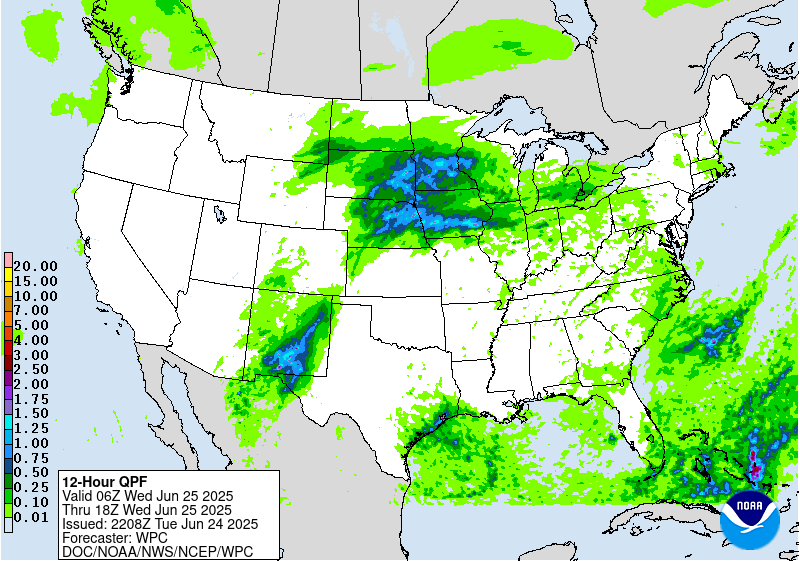
Day 1
Valid 01Z Wed Jun 25 2025 - 12Z Wed Jun 25 2025
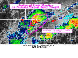
...THERE IS A MODERATE RISK OF EXCESSIVE RAINFALL OVER PORTIONS OF
CENTRAL AND SOUTHERN NEW MEXICO...
...New Mexico...
A strong warm core ridge centered over the Ohio Valley and Mid-
Atlantic with its western extent pushing back west beyond the
eastern portions NM. A steady south-north progression within the
mid and upper levels will send numerous smaller shortwave
perturbations through NM. Anomalous moisture ranking in the 99th
percentile via NAEFS and ECENS Climatological percentiles will
remain parked over the region. Morning activity left some southern
areas out of the mix today, but the 18z HREF probabilities of 0.5"+
suggest that this region remains a threat overnight, possibly from
convection moving in from the west. Local topographic effects
within this pattern will yield some significant rainfall potential
over areas that are prone to flash flooding, especially with the
burn scars still present near Ruidoso creating higher runoff
capabilities.
The difference the past 24 hrs. has been the expected influence of
the approaching trough out west providing a reinforcement of the
trailing upper jet with the amplitude of the pattern creating more
room further west for large scale ascent, and moisture advection
back into the western half of NM, even sneaking into Southeast AZ.
The entire evolution has spurred scattered to widespread
thunderstorm activity over the aforementioned regions with cold
pool mergers from storms likely to produce some upscale growth in
the evening as the convergence of cold pools will act to spawn more
multi-cell modes. The flash flood threat will linger through the
overnight time frame before finally settling down closer to
Wednesday AM.
The various risk levels were barely nudged as recent radar
reflectivity trends and 18z HREF probabilities of heavy rainfall at
various threshold indicate that local 2-4" totals remain possible
into early Wednesday.
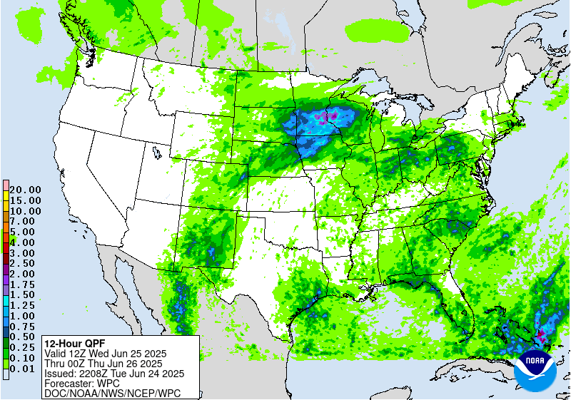
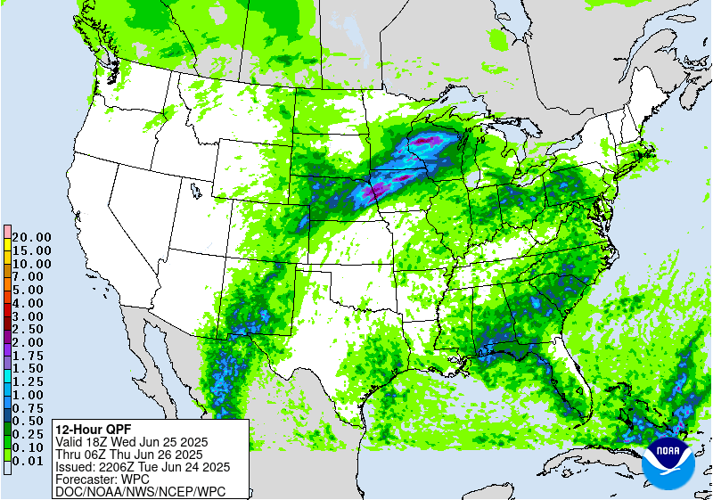
...Central Plains to Midwest...
Thunderstorms are most numerous near the NE/CO border and northwest
MO at this time as a shortwave enhances activity. A ring of fire
type of convective pattern remains from NM through portions of the
High Plains into the Central Plains and Midwest towards the Great
Lakes around the northwest periphery of the warm core ridge.
Activity is along and near a quasi- stationary front bisecting the
areas above. Areas of northeast KS, southwest IA, and northwest MO
are the main focus for flash flood concerns with saturated grounds.
Thunderstorms are likely to carry east and northeast into
Wednesday morning towards the Great Lakes.
A strong 700-900 kg/ms IVT pulse is advecting northeastward into
the Central Plains and Midwest, so the heavy rain threat with
2-3"/hr rates will certainly have potential for basically anywhere
in the Central Plains/Midwest domain. Recent trends suggest that
convection moving across southern NE would be a concern over the
next several hours. The nocturnal LLJ allows the stationary front
to begin lifting north in the form of a warm front tonight, in
theory. The mean layer flow orients more parallel to the front
creating an environment capable for cells to mature and begin
training over areas within proxy to the boundary.
Roth/Kleebauer
Day 1 threat area:
www.wpc.ncep.noaa.gov/qpf/94epoints.txt
Excessive Rainfall Discussion
NWS Weather Prediction Center College Park MD
854 PM EDT Tue Jun 24 2025
Day 2
Valid 12Z Wed Jun 25 2025 - 12Z Thu Jun 26 2025
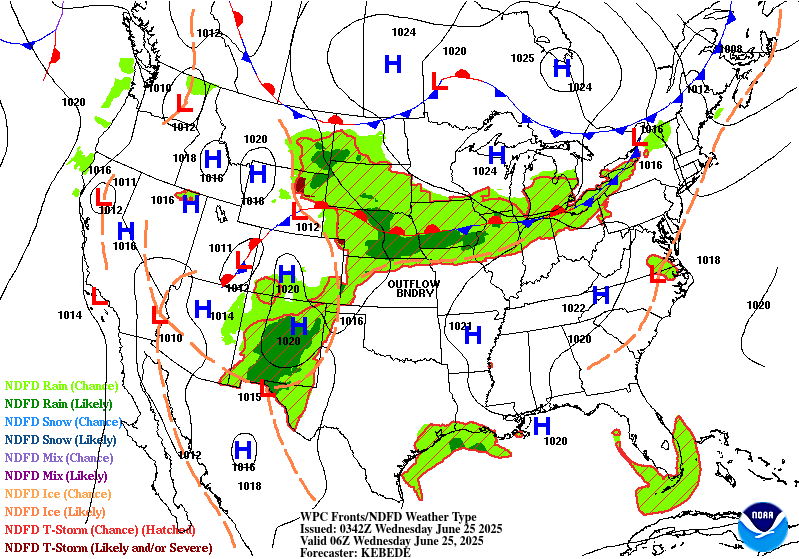
...THERE IS A SLIGHT RISK OF EXCESSIVE RAINFALL OVER PORTIONS OF
NEW MEXICO, CENTRAL PLAINS AND MIDWEST...
...2030Z Update...
Following a similar trend to the Day 1 update, the main adjustment
to New Mexico and Texas includes a Southward extension of the
Slight Risk area to the International Border based on HREF and REFS
EAS probabilities of 1-2". Coverage of rainfall is still expected
to diminish compared to yesterday, although additional significant
flash flooding is possible in light of ongoing activity. Depending
on overlap of rainfall, a Moderate Risk is still on the table for
future updates.
In the Upper-Midwest, the Slight Risk was expanded northeastward
based on a consensus amongst the HREF and REFS suite. Neighborhood
probabilities suggests rainfall amounts of 3-5" are possible as
thunderstorms develop and train along an east-west oriented front
amid highly anomalous precipitable water values around 2" (in the
99th percentile per the NAEFS). As this moist plume advects
eastward, diurnal heating along the front should spur scattered
thunderstorm development across the Northeast and Mid-Atlantic.
While weak wind profiles should limit overall storm organization
compared to further west, brief very heavy rainfall rates could
drive isolated flash flooding issues atop saturated soils in the
region and sensitive urban areas.
A Marginal Risk was also introduced over the eastern Gulf Coast as
a retrograding upper-low begins to slow down over the region.
Activity should remain fairly disorganized beneath this feature,
although isolated flash flooding is possible with saturated soils
in the region.
Asherman
...Previous Discussion...
...New Mexico...
Despite a smaller areal coverage anticipated for convection across
New Mexico for Wednesday, scattered thunderstorms will still
cause problems during afternoon initiation as ample heating during
the prime destabilization window (16-21z) will yield another
threat of heavy rainfall across the terrain and adjacent valleys in
Central and Southern NM. Current signals are nowhere near as
robust as the D1 time frame, but with forecasted significant
impacts the period prior, there's a greater threat of truly
compromised FFG's leading in, allowing for the bar to be very low
for flash flooding over areas that will see significant rainfall in
the areas referenced above. Hi-res ensemble blended mean QPF is now
solidly within the 1-2" range with locally higher totals across the
Sacramento's. Areal average 0.5-1" of rainfall is forecast over
much of South-Central NM and over the Sangre de Cristos with totals
potentially up to 2" in stronger convective cores. The overlap with
the previous period allows for at least a SLGT risk with a higher
end SLGT progged over the Sacramento's where convective initiation
is likely. A targeted upgrade is plausible within the two main
mountain areas in the state, especially when you factor in the
antecedent conditions for the period in question. If CAMs come in
more robust, or impacts during the D1 are severe enough to fully
compromise soils to where any convective threat could be deemed
significant.
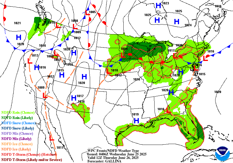
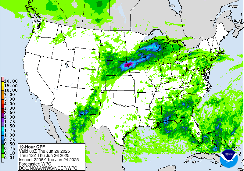
...Central Plains to Midwest...
Convective pattern across the Plains and Midwest at the end of the
D1 will translate northward into the Upper Mississippi Valley with
organized convection over NE/IA and SD/MN converging along the
propagating warm front leading to a swath of heavy rainfall across
much of the Southern 1/3rd of MN. All guidance is in agreement on a
pretty significant QPF shield moving through the area encompassing
Southern MN up through Northwest WI with some back-building
potential along the front as it migrates north and begins to slow
its momentum. Areal average of 1-2" with locally up to 4" totals
are forecast across that portion of the Upper Midwest, reflected
well within the NBM 90th percentile QPF signature, as well as
within the 12-00z time frame covered by the end of the 00z HREF
blended mean. This is just round 1 of what will be yet another
secondary convective initiation come Wednesday evening when another
strong shortwave and attendant IVT pulse comes pushing back over
Eastern NE, Western IA and points north. Additional heavy rainfall
will intersect many areas that will have seen significant totals
earlier in the period and the second half of the D1. The
compounding impacts will lead to scattered to widespread flash
flood instances as FFG's will be notably lower comparatively to
the before the previous rounds. Ensemble bias corrected mean is now
between 3-4" over a large area encompassing Southern MN into
Northwest WI with 2-3" positioned just to the southwest of MN. EC
AIFS output is in agreement with the positioning of the QPF maxima
anticipated, something that has not been the case over the past few
days, so we seem to be moving into a greater consensus. As a
result, there is a large high-end SLGT risk positioned from
Northeast NE up through MN into the western portion of WI. An
upgrade within anywhere in that zone is plausible in the coming
updates as multi-day impacts could spur some locally significant
flash flood prospects.
Kleebauer
Day 2 threat area:
www.wpc.ncep.noaa.gov/qpf/98epoints.txt
Excessive Rainfall Discussion
NWS Weather Prediction Center College Park MD
854 PM EDT Tue Jun 24 2025
Day 3
Valid 12Z Thu Jun 26 2025 - 12Z Fri Jun 27 2025
...THERE IS A SLIGHT RISK OF EXCESSIVE RAINFALL OVER PORTIONS OF
THE MIDWEST AND NORTHERN GREAT LAKES...
...2030 Update...
A Marginal Risk was also added over parts of the eastern Gulf Coast
as the aforementioned upper-low lingers overhead and overlaps with
rainfall from the day before. Otherwise, generally minor
adjustments overall to the overnight thinking. Could see the need
for targeted upgrades in the Midwest and Northeast/Mid-Atlantic
depending on overlap from Day 2, so stay tuned as high-resolution
guidance comes into range in subsequent updates.
Asherman
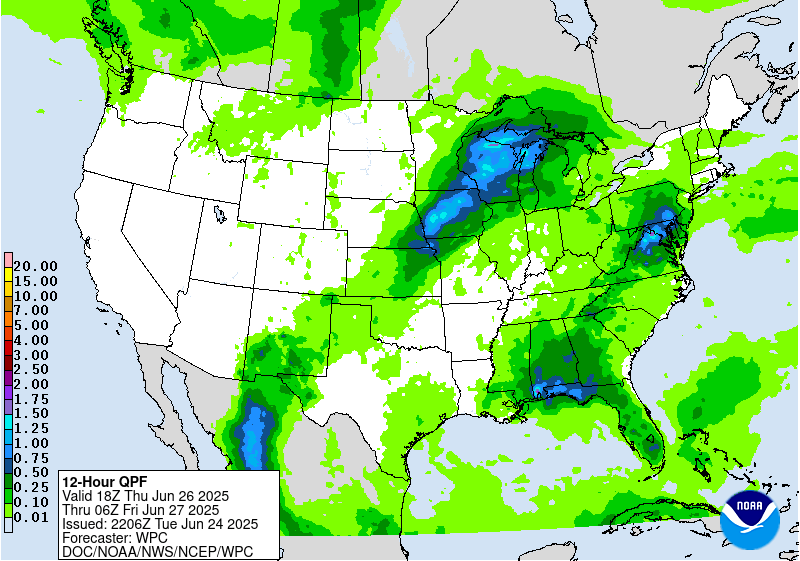
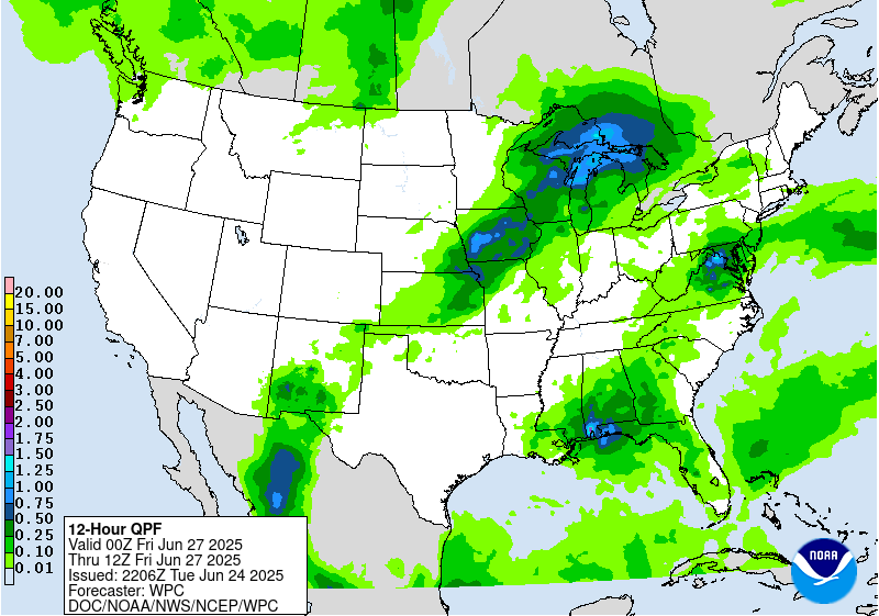
...Midwest...
The final shortwave in the progression bleeding over from the
previous D2 time frame will continue pushing northeast before
finally vacating the Upper Midwest later on Thursday. Heavy rain
threat will continue over parts of MN and WI before eventually
impacting the Western U.P. of Michigan before its departure.
Instability across the region will be significantly lower than
previous days with the warm front becoming stationary prior to
reaching the southern shores of Lake Superior. The threat for flash
flooding is most notably in the first 6-12 hr window of the
forecast with a sharp decline in the threat afterwards as the
pattern shifts with the ridge expected to be breaking down. 1-2"
with locally higher amounts will allow for flash flooding in any
area from IA up through MN/WI, especially in places where
significant rainfall has occurred in prior periods. A broad SLGT
risk remains in place over the Northern Great Lakes and Upper
Midwest with the biggest change being the extension down through
Central IA as trailing thunderstorms are forecast within the
frontal orientation Thursday afternoon and evening.
...New Mexico...
Isolated to scattered thunderstorms across the Sacramento's and
adjacent desert will maintain at least some threat for flash
flooding given expected wet antecedent conditions following
previous multi-day convective impact. Coverage and magnitude will
be lower than previous periods, but still enough of a threat and
coverage to warrant a MRGL continuation.
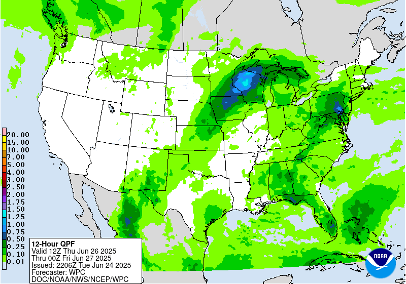
...Mid Atlantic...
Disturbance rounding the northern periphery of our massive ridge
will ultimately slide down through the Mid Atlantic during the
mid to late-afternoon hrs. on Thursday. The combination of strong
diurnal destabilization during the daytime and prominent moisture
lingering over the area will create a very buoyant environment
capable of strong thunderstorm genesis anywhere from NY state down
through the Central Mid Atlantic including; MD/PA/DE/Northern WV
and VA. Current projection of QPF is fairly isolated in the heavier
convective outputs with some deterministic depicting totals as
high as 2-3" in spots. Initial assessment of the setup leads
towards a low end MRGL risk for now, but will assess how models
handle the shortwave disturbance and proposed ascent pattern within
a fairly unstable environment over the next few days.
Kleebauer
Day 3 threat area:
www.wpc.ncep.noaa.gov/qpf/99epoints.txt
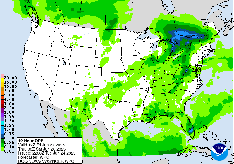
Extended Forecast Discussion
NWS Weather Prediction Center College Park MD
327 PM EDT Tue Jun 24 2025
Moisture advection around the southeastern U.S. upper ridge
combined with shortwaves aloft and a wavy frontal boundary will
provide a favorable environment for convection for portions of the
northern tier Friday/Saturday. An initial wave moving across the
Lower Great Lakes and Northeast Friday-Saturday will allow for some
possibly heavy rain in the Interior Northeast on the cusp of the
instability gradient and where a weak surface low tracks along the
front. A Marginal Risk remains in effect for Days 4 and 5 over
portions of the Northeast (and the central Appalachians for Day 4).
High QPF maxes on Friday may allow an upgrade at some point.
delineated in the Day 4/Friday and Day 5/Saturday EROs for
localized flash flooding with this activity.
Another shallow upper trough and frontal system will push through
the north-central U.S. Friday night into Sunday, providing forcing
for thunderstorms. Instability is likely to be high (MUCAPE of
3000-5000 J/kg already shown by the global models. The Day 4
Marginal Risk is maintained for ND/MN with more east-west expansion
to the Day 4 Marginal Risk from SD into the U.P. of Michigan based
on convergence along a frontal zone. Convection is forecast to
shift southeast across the Midwest and central Plains/Middle
Mississippi Valley early next week ahead of the trough and front.
Ring of fire moisture advection over the southern Rockies/adjacent
high plains continues with elevated moisture through Saturday. Day
4 and 5 Marginal Risks are now in effect for the Sacramento
Mountains for diurnally driven isolated flash flooding. Monsoonal
moisture looks to increase early next week, bringing rain and
thunderstorm chances to the southern and central Rockies and High
Plains.
The central Gulf Coast may see a few days of more focused
convection, with heavier amounts possible early next week (after
the ERO period, and would have to battle against high flash flood
guidance to see flooding concerns there).
Weakening/suppression of the east-central ridge Friday into
Saturday will allow moderation of temperatures with a backdoor cold
front over much of the Mid-Atlantic Friday, though warming is
expected early next week. The north-central U.S. can expect
temperatures to be 5-10 degrees above average Friday- Saturday and
then cool behind a cold front. Temperatures in the interior
Northwest
will warm by early next week under an upper ridge and north of the
trough along the Coast. The Desert Southwest can expect a return to
above normal temperatures starting Sunday from advection east of
the West Coast trough.
Jackson


