Excessive Rainfall Discussion
NWS Weather Prediction Center College Park MD
849 PM EDT Thu Jun 26 2025
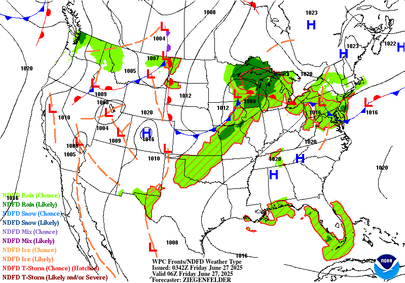
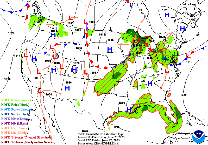
Day 1
Valid 01Z Fri Jun 27 2025 - 12Z Fri Jun 27 2025
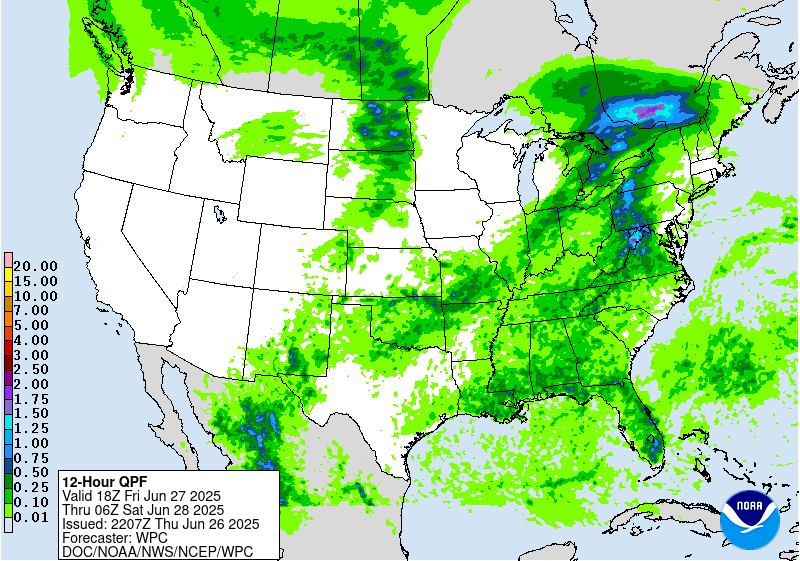
...THERE IS A SLIGHT RISK OF EXCESSIVE RAINFALL ACROSS PARTS OF
THE CENTRAL PLAINS, MIDWEST, & GREAT LAKES...
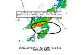
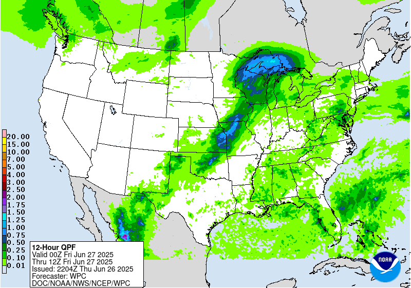
An upper level trough will pivot eastward across the Upper MS
Valley and Upper Great Lakes region Thursday night into early
Friday. Enhancing the deep-layer forcing will be the curved 90kt
upper level jet streak that will be skirting the U.S.-Canadian
border. Ahead of the upper shortwave trough/surface front --
850-700 mb moisture flux anomalies are noteworthy (1.5-2.0 standard
deviations above normal), as is the 0-6km bulk shear values
(35-45+ kts). This will likely continue to support more widespread,
organized convective line segments into the overnight across the
elongated Slight Risk area, with embedded mesocyclones possible.
When compared to continuity, cleared the former western portions of
the risk areas based on radar reflectivity trends and 18z HREF
output.
...Mid Atlantic & Upper Ohio Valley...
Relatively light (generally 20kt or less) deep-layer shear with
a near upper level high overhead between a retrograding TUTT cell
in the Southeast and Westerlies to the north has caused a Florida-
like situation to unfold today, with outflow boundaries moving in
from many directions of the compass, which has caused CIN to set in
across much of the region. The most interesting aspect has been a
synoptically enhanced sea breeze, a possible cold front that
cleared portions of the Eastern Shore this afternoon and evening
and has led to patches of stratus in its wake over portions of NJ
& DE. The 18z HREF has significantly overforecast early evening
convection in the DC area in the hours leading up to this
discussion's issuance. With convective coverage becoming more
isolated due to the broad CIN development, dropped the risk in the
region to Marginal. The 18z HREF indicates that the threat of heavy
rainfall on an isolated basis should end by midnight, holding on
the longest across portions southern PA, the Virginias, and near
the shores of Chesapeake Bay.
...New Mexico...
Isolated to scattered thunderstorms across the Southern High Plains
and the Texas Big Bend should maintain at least some threat for
flash flooding given wet antecedent conditions following a wet
multi-day convective period. Remaining elevated moisture and
sufficient buoyancy will maintain the diurnally driven
thunderstorms through roughly 05z, based on the 18z HREF output.
Heaviest thunderstorms will be capable of 1-2" with the peak QPF
max probably closer to 3". The previous MRGL risk was maintained,
but trimmed on its western side per radar trends and the 18z HREF
output.
Roth/Hurley
Day 1 threat area:
www.wpc.ncep.noaa.gov/qpf/94epoints.txt
Excessive Rainfall Discussion
NWS Weather Prediction Center College Park MD
849 PM EDT Thu Jun 26 2025
Day 2
Valid 12Z Fri Jun 27 2025 - 12Z Sat Jun 28 2025
...THERE IS A SLIGHT RISK OF EXCESSIVE RAINFALL OVER PORTIONS OF
NORTHERN NEW YORK AND NORTHERN NEW ENGLAND...
...Northern NY-New England...
21Z update... the latest guidance maintains the scenario described
below with similar QPF amounts, particularly from northeast New
York to northern Vermont, therefore the Marginal and Slight Risk
areas were maintained as is.
Campbell
The forecast for a focused corridor of heavy rainfall associated
with an MCS and trailing convection crossing from southeastern
Canada into portions of Update New York/northern New England
remains on track. While there are expectedly some variances on the
possible MCS path which add some east-west uncertainty, all
guidance is still in good agreement that the track will clip areas
south of the international border bringing an attendant flash flood
threat. Deterministic guidance indicates the potential of rainfall
totals between 1-3", with ensemble probabilities of 2"+ between
15-25%. A small eastward adjustment of the Slight Risk area was
added based on these latest ensemble probabilities. Elsewhere,
prior forecast has remained consistent.
...Northern Plains...
21Z update... The progressive nature of the expected shortwave will
help limit the severity of any local flooding that arises. The
Marginal Risk currently in place remains without any changes at
this time.
Campbell
A quick moving shortwave across the North-Central tier of the CONUS
will lead to scattered thunderstorm activity capable of locally
heavy rainfall and flash flood prospects. The best threat will be
over Northern ND into the Red River area where some urbanized zones
will have a greater threat for flash flooding. A quick 1-3+" is
likely anywhere over Central ND into Northwest MN. This threat is
within the lower end of the MRGL risk threshold and will be
monitored closely to see if the risk is warranted, or needs any
expansion.
...West Texas into New Mexico...
21Z update... The threat for localized heavy rainfall remains
spotty across the area given the pattern. The Marginal Risk area
continues to highlight the locations that may have local flash
flooding during this period.
Campbell
Continued threat of widely scattered thunderstorms across far West
TX into NM will allow for isolated flash flood concerns over areas
that will have seen several days of heavy convective impacts with
compromised FFG's. Local 1-2" is possible in the period with the
highest threat likely over the Sacramento's down through the
Guadalupe Mtns. and adjacent valleys. A MRGL risk was maintained to
cover for the threat.
Day 2 threat area:
www.wpc.ncep.noaa.gov/qpf/98epoints.txt
Excessive Rainfall Discussion
NWS Weather Prediction Center College Park MD
849 PM EDT Thu Jun 26 2025
Day 3
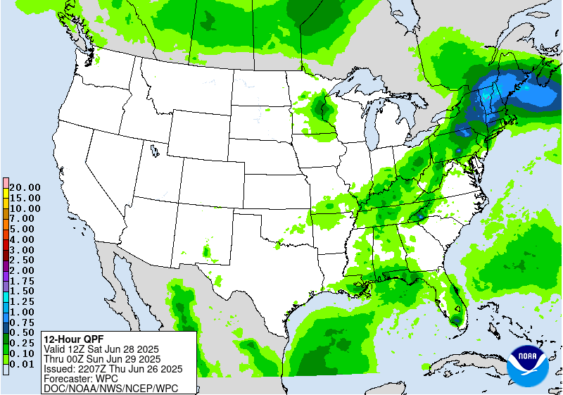
Valid 12Z Sat Jun 28 2025 - 12Z Sun Jun 29 2025
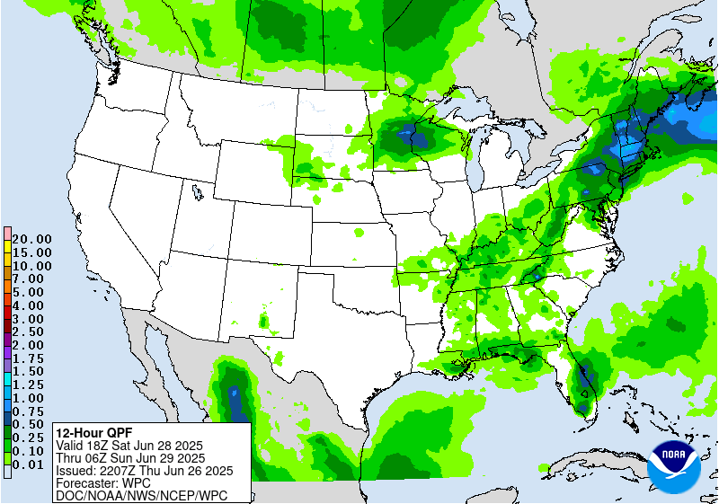
...THERE IS A MARGINAL RISK OF EXCESSIVE RAINFALL ACROSS PORTIONS
OF THE NORTHERN PLAINS AND UPPER MIDWEST, THE NORTHEAST, AND
SOUTH-CENTRAL NEW MEXICO...
...Northern Plains and Upper Midwest...
21Z update... The latest guidance continues to signal the highest
QPF amounts to be over central Minnesota into western/northern
Wisconsin with areal averages of 1 to 3 inches with locally higher
amounts still possible. The environment looks to remain favorable
for repeating cells, thus maintaining an elevated threat for
localized flash flooding.
Campbell
Next approaching upper shortwave trough, with a 90kt upper level
jet streak on the lee side, will generate a compact area of fairly
robust, transient deep-layer forcing over the outlook area later in
the period (especially Sat night). MUCAPEs are expected to soar
within the warm sector prior to the surface cold frontal passage --
i.e. aoa 4,000 J/Kg per the GFS. This along with PWs getting near
1.75" will lead to more organized, widespread convection by
Saturday night as the activity likely grows upscale with the
increasing pre-frontal low-level inflow (30-40kts at 850 mb). The
00Z guidance indicates significant latitudinal spread in the
heavier QPF, and as a result, have maintained the Marginal Risk
from yesterday's Day 4 ERO. However, the potential for an upgrade
to Slight is certainly plausible given the kinematic and
thermodynamic profile, especially after 00Z Sun when the Corfidi
Vectors decrease to 10kt or less (thereby enhancing the risk for
cell training).
...Northeast...
21Z update... There is an increasing potential for heavy rainfall
to develop across western Pennsylvania and surrounding areas as
the frontal boundary sags southward and taps into the pooled PW
values of 1.5-2". The latest model guidance are showing local
maximums upwards of 2 inches possible and the ERO first guess
supports expanding the Marginal Risk from eastern Pennsylvania
further west into eastern Ohio, West Virginia and western Maryland.
Campbell
Upper shortwave trough pushes across the Northeast by late Sat,
then off the coast Sun morning. The bulk of the rainfall will fall
during the first half of the period (during the day Sat),
coinciding with the most favorable pre-frontal deep-layer
instability and moisture (PWs 1.75-2.00+ inches). The 00Z guidance
shows considerable spread with the heaviest QPF, though are fairly
similar with the max totals (1.5-3.0"). Given the spread in the
model QPFs, along with the progression of the front and fairly
quick diminishment in instability after 00Z Sun, for now will
maintain the Marginal Risk.
...New Mexico...
21Z update... No changes were made to the Marginal Risk area.
Campbell
Maintained a targeted Marginal Risk area over/near the Sacramento
Mtns, particularly the burn scar areas from the 2024 fires (Blue 2,
South Fork, and Salt burn scars). QPF trends (coverage, intensity)
are similar to Day 2, with the moist S-SE low-level upslope flow
likely resulting in a concentrated area of heavier rainfall across
the Sacramento Mtns and eastern foothills. The flash flood
potential is expected to remain isolated/localized.
Hurley
Day 3 threat area:
www.wpc.ncep.noaa.gov/qpf/99epoints.txt
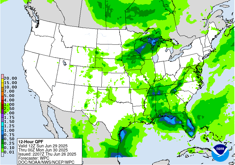
Extended Forecast Discussion
NWS Weather Prediction Center College Park MD
227 PM EDT Thu Jun 26 2025
Thunderstorms are likely to form ahead of the broad but shallow
upper trough and a surface frontal boundary in the Upper Midwest to
central Plains Sunday. Global models have already been showing
high instability with MUCAPE 4000-6000 J/kg for this region, so
strong storms are possible, and this will also support heavy rain
rates that could cause flash flooding. A Marginal Risk is in place
in the Upper/Middle Mississippi Valley back into the south-central
Plains for the Day 4/Sunday ERO. By Monday the setup will be
similar, but with the trough and cold front pressing southeast. A
large Marginal Risk is located along and ahead of the front from
the Ohio/Tennessee Valleys, Mid/Lower Mississippi Valley, and the
south-central Plains where storms are likely in the moist and
unstable airmass on Day 5/Wednesday. For both days, further
refinements may be needed in future cycles, including possible
embedded Slight Risks, but model agreement in the specifics remains
low for now. The front will continue to push eastward Tuesday,
leading to a wet day in the Northeast/Mid-Atlantic before drying
out midweek, and southward for thunderstorm chances across the
Southeast Tuesday-Wednesday. Even before the front approaches,
scattered thunderstorms are likely farther south in the broad warm
sector as well. There will be less forcing for organization and
sustaining of storms across the southern tier away from the upper
jet, but instability could allow for heavy rain rates that may
cause non-zero chances of localized flash flooding, but that are
likely dependent on smaller scale boundaries and are less
predictable at this point. One area of focus that the models show
for some heavier rain is across the central to eastern Gulf Coast
region. Will monitor if there will be flash flooding concerns there
but it would have to battle with very high flash flood guidance.
Monsoonal moisture is likely to increase next week in the
Southern/Central Rockies and Plains with southerly flow under the
upper ridge, thus increasing coverage of and rain amounts in
storms. Marginal Risks are in place for the southern High Plains
Day 4/Sunday and stretching north into eastern Colorado Day
5/Monday as the back end of the front nears. Areas like the
Sacramento Mountains, where the steep terrain and burn scars cause
the area to be particularly sensitive to rain, are likely most
vulnerable to rain causing potential flash flooding, especially
with wet antecedent conditions there.
Elsewhere, showers and storms may develop across parts of the
Great Basin Monday and toward the Northern Rockies by Tuesday. Then
depending on a shortwave, rain chances are forecast to increase in
the north-central U.S. by midweek.
Temperatures are forecast to be around 5-10 degrees above average
across the Midwest/Great Lakes early next week, while the southern
half of the Plains to Southeast can expect typical summer heat.
HeatRisk shows some Major (level 3 of 4) areas in these regions,
indicating heat levels that affect anyone without effective cooling
and/or adequate hydration. Temperatures and dewpoints will
decrease behind the cold front as it progresses southeast. Farther
west, building heat is expected next week as an upper ridge takes
hold. Temperatures in the Northwest are likely to be 10-15 (locally
20) degrees above normal, for highs nearing 100F. In the Desert
Southwest, temperatures a few degrees above already high averages
will equate to 100s and 110s. Moderate to Major HeatRisk is shown
for much of the Interior West peaking Monday-Tuesday.
Fracasso/Tate


