Excessive Rainfall Discussion
NWS Weather Prediction Center College Park MD
1143 AM EDT Tue Jul 1 2025
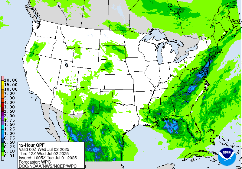
Day 1
Valid 16Z Tue Jul 01 2025 - 12Z Wed Jul 02 2025
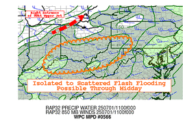
..THERE IS A MODERATE RISK OF EXCESSIVE RAINFALL OVER NORTHERN
PORTIONS OF THE MID-ATLANTIC REGION...
...Northeast through Ohio Valley...
16Z Update: The threat for the Mid Atlantic remains locked in for
the D1 with the MDT risk maintained over the previous areas, but
allowed for an expansion on the northeast flank to encompass all of
the Philadelphia metro, including adjacent areas of Southern NJ.
12z KIAD sounding has come in with a robust 2.07" PWAT, a daily
record for 7/1. The wet bulb zero height is also a daily record
indicating a particularly deep warm-cloud layer situated within the
lower troposphere. This type of environment along with a well-
defined tall, skinny CAPE signature is representative of a strong
prospect for not only heavy rainfall, but significant rate driven
rain cores (2-3+"/hr) that can efficiently drop several inches of
rain in a short span of time. The area encompassing the Central Mid
Atlantic has a variety of factors for enhancing the potential
(urbanization, antecedent moist grounds), but enhanced rates
increase the threat by a respectable margin and historically points
to a higher flash flood threat in both coverage and magnitude for
a period. Recent CAMs are very much depicting several small QPF
maxima littered over the Mid Atlantic with the highest signals
positioned over Northern VA up through the MD Piedmont and points
east-northeast. The alignment of the heavier QPF situated over
Southeast PA into Northern DE and Southern NJ is likely in part to
a targeted convective initiation and training point within a narrow
sheared surface trough situated over the region as noted via the
latest visible sat channels. The assessment this morning only
provided greater credence to the threat with the previous
discussion still well in-play in the overall outline of an elevated
risk for flash flooding. Given some of the latest trends within the
QPF and mesoscale evolution this morning, the MDT risk expansion
through more of Southeast PA into Southern and Central NJ was
generated.
Higher end SLGT risk is now forecast across much of WV as locally
heavy rainfall with potential for up to 2-2.5"/hr rates will likely
cause problems within the complex terrain as funneling effects
tend to exacerbate any convective threat in the state. This threat
extends into far Southwest PA with focus around the periphery of
an advancing MCV currently migrating through Southern OH.
Kleebauer
..Previous Discussion..
Per collaboration with WFOs CTP, PHI, and LWX, we have included a
Moderate Risk to the Day 1 ERO across parts of the northern Mid
Atlantic Region to include NoVa and the DC-Balt metro regions,
northern DE and into southeast PA.
Longwave upper trough over the Upper Great Lakes/Midwest early
this morning will pivot eastward Tue-Tue night, pushing east of the
Appalachians Wed morning. Embedded within the longwave trough is a
shortwave, currently along the IA/IL/MO tri- state area, which
will track across the OH Valley later this afternoon and across the
Mid Atlantic later this evening and overnight. This shortwave
should enhance the broad- scale across the Mid Atlantic region
(especially), while low-level frontogenesis also gets a boost south
of the 90-100kt upper jet streak in the lee of the large-scale
trough.
0-6km bulk shear values increasing to 25+ kts within the inherited
broad Slight Risk area (30-40+ knots over the northern Mid Atlantic
into the Northeast) will support the formation of
widespread/multi-cluster line segments ahead of the upper
trough/surface cold front during peak diurnal instability hours
this afternoon into the evening. MUCAPEs peak between 2000-3000
J/Kg, while TPWs remain around 2 standard deviations above normal
for early July (between 2.00-2.25" within the non-convective
environment across much of the Mid Atlantic into southern New
England). The concern over the Slight and especially Moderate Risk
areas will be with upwind propagation and cell training, as the
pre-frontal southwesterly low-level flow (20-25 kts at 850 mb
becomes nearly parallel and of similar magnitude as the mean
850-300 mb flow. 00Z HREF and RRFS probabilities of 24hr QPF
exceeding 3" climb above 60% within much of the Moderate Risk
area (highest with the RRFS), while probs exceeding 5" within the
24hr period reach 40-60% in spots per the RRFS (though 20-25% tops
per the HREF). Given the favorable thermodynamic profile (high
CAPE/PW environment) along with the broad-scale forcing, anticipate
areas of 2 to 3+ inch/hr rainfall rates this afternoon and evening.
The Moderate Risk area also encompasses areas recently hit by
heavier rainfall, evidenced by the lower FFGs (in some areas, 1 hr
FFGs 1.00" or less). This includes areas SE PA including the
Middletown/Lancaster/Lebanon/Redding areas that received 4-7" of
rain on Monday.
Hurley
...West Texas into New Mexico...
16Z Update: The current SLGT risk was generally maintained with
only a minor expansion to the east to include more of the Western
Rolling Plains adjacent to the Concho Valley. Quasi-stationary
front will be the focal point later this afternoon and evening with
typical diurnal heat flux providing greater buoyancy with the
regional environment allowing for several thunderstorms to develop
in proxy to the boundary. 12z KMAF sounding was right up against
the daily record for PWATs and well beyond the 90th percentile for
the date meaning the environment is ripe for locally heavy precip
potential once the convective regime initiates. 12z HREF probs are
robust for both the neighborhood >2" indicator and the >1" EAS
field which notes a "bullseye" of up to 50% located over parts
of the Upper Trans Pecos into the adjacent Guadalupe Mtns. The
other area of concern will lie within that quasi-stationary front
with a elevated signature for >2" situated from the NM/TX border,
east across the Northern Permian Basin. Enhanced hourly rates will
be the primary threat for the period with 1-2"/hr rates very likely
in any strong convective cores. Look for scattered flash flood
signals within the above zones with the greatest threat positioned
over Southeast NM and adjacent TX Caprock as noted in the QPF/prob
fields.
Kleebauer
..Previous Discussion..
Farther south/west along the stalled frontal boundary...convection
is expected to be develop within a region of decent CAPE and
precipitable water values in excess of 2 standard deviations above
climatology. This area will also benefit from weak upper level
vorticity/shear axis within the broad-scale ridge, with tropical
moisture feeding in per the low-mid layer southeasterly flow.
850-700 mb moisture transport is pretty solid across the outlook
areas, but especially within the Slight Risk region across parts of
West TX into southeast NM where the 850-700 mb moisture flux
standardized anomalies peak between 3-4 standard deviations above
normal per the 00Z SREF and GEFS. Given the relatively healthy
low-level flow compared to the overall weaker mean flow, areas of
heavy, possibly excessive rainfall are anticipated, especially
within the Slight Risk area, considering the uptick in upwind
propagation and thus chances for cell training.
Hurley
...South Texas...
16Z Update: Only minor adjustments necessary for the SLGT risk
across Deep South TX as the previous forecast remains on track.
Little deviation in the prob fields from overnight allowed for a
continuation of the SLGT risk with emphasis on greatest threat
likely over the Lower RGV, including the cities of Brownsville and
McAllen.
Kleebauer
..Previous Discussion..
An influx of abnormally high TPW from the remnants of Tropical
Cyclone Barry (2.2 to 2.4", which is close to 3 standard
deviations above normal for early July) will combine with a
modestly unstable environment (MUCAPEs increasing to 1500-2500
J/Kg) in producing very heavy short-term rainfall rates later this
afternoon/evening and potentially later into the overnight period.
Both the HREF and RRFS ensembles show high probabilities (>50%) of
3+ inch rainfall, with 30-40% probs of exceeding 5 inches.
Therefore expect more than a localized risk of flash flooding
(i.e. Slight vs Marginal) across portions of South Texas from
Corpus Christi south through Brownsville and the RGV.
Hurley
Day 1 threat area:
www.wpc.ncep.noaa.gov/qpf/94epoints.txt
Excessive Rainfall Discussion
NWS Weather Prediction Center College Park MD
1143 AM EDT Tue Jul 1 2025
Day 2
Valid 12Z Wed Jul 02 2025 - 12Z Thu Jul 03 2025
...THERE IS A SLIGHT RISK OF EXCESSIVE RAINFALL ACROSS PORTIONS OF
SOUTHEAST VIRGINIA AND NORTHEAST NORTH CAROLINA...
...Lower Mid Atlantic and Southeast...
Pre-frontal convection will likely be ongoing across the Mid
Atlantic and Southeastern Seaboard Wednesday morning, with
additional line segments upstream as well prior to the passage of
the surface front and upper trough axis later in the day. Along the
axis of 2.25"+ TPWs, by early afternoon (17-18Z), both the HREF
and RRFS ensembles show an uptick in >2"/hr rainfall rates across
southeast VA and northeast NC, particularly the RRFS (25-50%).
Available high-res CAM guidance (NAM Nest, FV3, and RRFS) all show
pockets of 3-5+ inch totals within the Slight Risk area. Elsewhere
within the Marginal Risk area stretching through much of the
Southeast, anticipate the flash flood threat to be more
isolated/localized as 0-6 km bulk shear values remain aob 20kt
(implying more pulse/less organized convection).
...West Texas into parts of the Southwest...
Continued moist, southeasterly low-level flow (850-700 moisture
transport/flux standardized anomalies +3 to +4 again from West TX
into NM) will set the stage for numerous showers and storms again,
especially during peak heating hours Wed afternoon and evening.
Strong low-level inflow is in some areas double the mean 850-300 mb
flow, thus resulting in Corfidi vectors opposing the low-level
wind. This will likely lead to cell training, especially where the
southeasterly low-level flow leads to more upslope enhancement.
Right now, the guidance (including the CAMs that go out through
Day 2) show considerable spread with the heavier QPF. Therefore for
now will maintain a more isolated (Marginal) flash flood risk, as
later shifts will evaluate once the period (Wed-Wed night) gets
within the remainder of the high-res CAM windows.
Hurley
Day 2 threat area:
www.wpc.ncep.noaa.gov/qpf/98epoints.txt
Excessive Rainfall Discussion
NWS Weather Prediction Center College Park MD
1143 AM EDT Tue Jul 1 2025
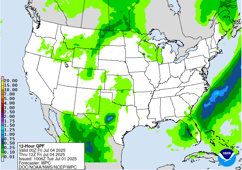
Day 3
Valid 12Z Thu Jul 03 2025 - 12Z Fri Jul 04 2025
...THERE IS A SLIGHT RISK OF EXCESSIVE RAINFALL ACROSS WESTERN
PORTIONS OF THE FLORIDA PENINSULA...
...Southern Georgia through northern and central Florida...
Subtle changes were made to the Slight and Marginal Risk areas
inherited from yesterday's Day 4 ERO. Southern periphery of the
longwave upper trough crosses the area Thu-Thu night, with the
guidance showing embedded shortwaves (possibly convectively-
enhanced) reaching South FL toward the end of the period (12Z Fri).
Ahead of the nearly stationary surface front, onshore west to
southwest low-level inflow from the eastern Gulf will likely lead
to a more focused area of low-level moisture transport/flux
convergence over much of the west coast of FL, especially north of
Ft. Myers to include the Tampa-St. Pete area, where 0-6km bulk
shear values do approach 25 kts (allowing for more
organized/widespread convective clusters). The RRFS is most
particularly robust with the QPF within the Slight Risk area (areas
of 3-6+ inches), which considering the thermodynamic
environment/deep subtropical moisture (TPW values 2.25 to 2.50"),
is certainly plausible. Especially considering the onshore low-
level inflow will likely exceed (perhaps double) the mean 850-300
mb wind), enhancing the potential for cell training. Even with a
more limited (tall/skinny) CAPE profile, sub-hourly rainfall rates
of 2.5-3.0+ inches within this environment will be possible,
especially within the Slight Risk area.
Elsewhere, few changes were made to the inherited Marginal Risk
area across the Northern Plains-Upper MS Valley and again across
West TX into the Southwest (including southern-central Rockies).
Guidance at this point shows considerable spread to support
anything more than a Marginal.
Hurley
Day 3 threat area:
www.wpc.ncep.noaa.gov/qpf/99epoints.txt


