Excessive Rainfall Discussion
NWS Weather Prediction Center College Park MD
800 PM EDT Fri Jul 4 2025
Day 1
Valid 01Z Sat Jul 05 2025 - 12Z Sat Jul 05 2025
...THERE IS A SLIGHT RISK OF EXCESSIVE RAINFALL IN AND NEAR
NORTHERN MINNESOTA & SOUTH-CENTRAL TEXAS...
...Central Texas...
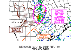
The mid-level remains of Barry saw significant rejuvenation from
the convective event on Friday morning and early afternoon, which
has ramped up the effective bulk shear available when compared to
this time last night. The combination of this mid- level
circulation, precipitable water values of 2-2.25" (+3 std dev above
normal), and areas of 2000+ J/kg of ML CAPE should lead to another
overnight maximum for the warm core circulation. The 18z HREF
isn't as emphatic with the signal for heavy rainfall, but the
environment continues to support hourly amounts to 3" with local
maximum of 6", assuming no long term backbuilding or training
occurs. The primary threat appears to be overnight during the usual
06z onward convective maximum for such a system with an upper
level high overhead. Shifted the 18z HREF footprint a little more
southward to better fit the southeast drift seen in water vapor
imagery with the mid-level circulation.
...Northern/Central Plains to the Upper Midwest...
Moderate to heavy amounts associated with training storms are still
expected early on across northern MN before the whole convective
area becomes progressive to the southeast. The various risk areas
were pared back on their west and north sides to accommodate
convective progression thus far and the signal in the 18z HREF.
Hourly rain amounts up to 2.5" remain possible where cell training
occurs this evening/tonight in northern MN.
...Western Florida...
Deep moisture pooling just east of a weak surface low offshore
Tampa and an upper low will continue to support an environment
conducive to heavy rainfall through the evening and overnight hours.
Hourly rain amounts up to 2.5" are possible where short, training
convective bands occur off the Gulf overnight.
...Northern Intermountain West/Rockies...
While most of the activity is expected fade after sunset,
convection is expected to hold on the longest across portions of
MT. Pared back the risk areas per convective progression thus far
and the signal in the 18z HREF.
Roth
Day 1 threat area:
www.wpc.ncep.noaa.gov/qpf/94epoints.txt
Excessive Rainfall Discussion
NWS Weather Prediction Center College Park MD
410 AM EDT Sat Jul 5 2025
Day 1
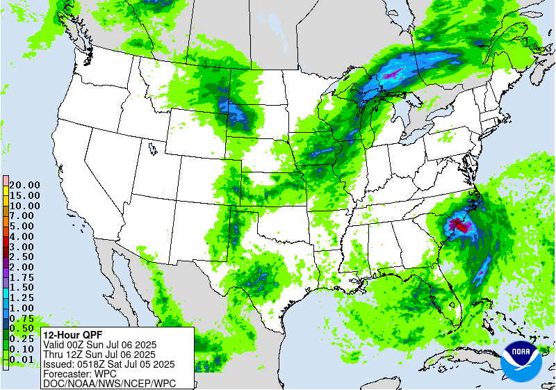
Valid 12Z Sat Jul 05 2025 - 12Z Sun Jul 06 2025
...THERE IS A SLIGHT RISK OF EXCESSIVE RAINFALL FOR A PORTION OF
CENTRAL TEXAS AND THE COASTAL CAROLINAS...
...Central Texas...
Concerns remain for additional heavy rain and flooding across
portions of South-Central Texas and the Hill Country. Overnight
guidance shows another surge of deeper moisture pushing north
across central Texas, with PWs at or above 2 inches bisecting the
state today. Many of the hi-res members show scattered storms
developing along this axis this afternoon. Fortunately, most depict
these storms initiating outside of those areas hardest hit by
yesterday's rains. However, there is some indication that storms
may drift west back into those areas and there is some overlap
between those inundated areas and where the new HREF is showing
high neighborhood probabilities for additional accumulations
exceeding 3 inches.
...Southeast...
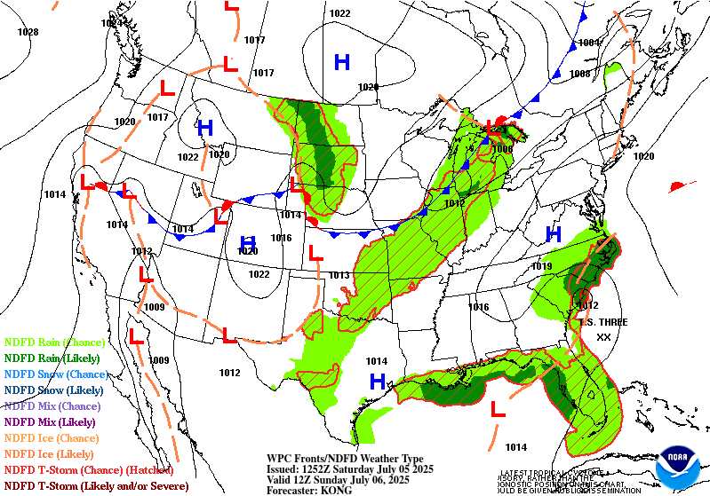
Tropical Depression Three is expected to intensify some as it
moves northwest and is expected to make landfall along the central
South Carolina coast near the end of the period. The potential for
efficient, heavy rainfall producing bands will increase as onshore
flow ahead of system pushes PWs above 2.25 inches along portions of
the South and North Carolina coasts. This moisture along with deep,
warm cloud layers will support periods of heavy rain, with locally
heavy amounts. The forecast track and general consensus of the
guidance shows the greatest threat for heavy amounts centering from
the Grand Strand toward Cape Fear. HREF neighborhood probabilities
for amounts over 3 inches are highest in this region. A small
targeted Slight Risk was placed over this area, with the greatest
threat for flash flooding expected to focus over urbanized and
poor drainage areas.
Further to the south, a trailing boundary and axis of deep moisture
will support showers and storms with locally heavy amounts across
central Florida.
...Northern High Plains...
A well-defined shortwave trough will move from the Northwest into
the northern High Plains. The associated large-scale forcing,
along with increasing moisture, supported by low level
southeasterly flow, will encourage shower and thunderstorm
development. PWs are expected to increase to ~1 to 1.25 inches (1
to 1.5 std dev above normal), with the deeper moisture and greater
anomalies centering from southeastern Montana into the Black Hills
region. While a widespread heavy rainfall event is not expected,
heavy rainfall rates and some potential for redeveloping storms may
produce locally heavy amounts (greater than an inch) and isolated
runoff concerns.
...Upper Midwest to the lower Missouri Valley...
A shortwave trough will continue to advance east out of the
northern Plains and across the Upper Midwest/Great Lakes. This will
push the associated cold front further south and east, with low
level southeasterly flow supporting a deep moisture pool (PWs ~2
inches). This will support widespread shower and thunderstorm
development across the region. While some southwest to northeast
training may elevate the potential for heavy amounts and flooding
concerns, storms are expected to be generally progressive. One area
where a potential upgrade may be necessary is across portions of
central and eastern Iowa, where some of the hi-res guidance shows
an initial round of storms developing along a prefrontal trough,
followed by a second round along the front. HREF neighborhood
probabilities indicate that totals in excess of 2 inches are
likely, with some potential amounts over 3 inches across this area.
Pereira
Day 1 threat area:
www.wpc.ncep.noaa.gov/qpf/94epoints.txt
Excessive Rainfall Discussion
NWS Weather Prediction Center College Park MD
410 AM EDT Sat Jul 5 2025
Day 2
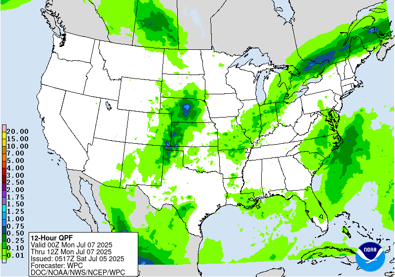
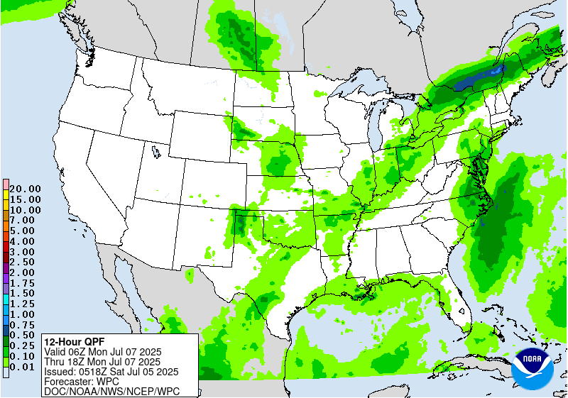
Valid 12Z Sun Jul 06 2025 - 12Z Mon Jul 07 2025
...THERE IS A MARGINAL RISK OF EXCESSIVE RAINFALL FROM THE GREAT
LAKES TO THE MID MISSISSIPPI VALLEY/OZARKS, PORTIONS OF THE
CENTRAL AND SOUTHERN HIGH PLAINS, AND ACROSS THE CENTRAL AND
EASTERN CAROLINAS...
...Central Texas...
While PWs are expected to come down, moisture will remain
sufficient for storm development and the potential for additional
locally heavy amounts. The overnight model consensus places the
greater threat further west than the greater Day 1 threat, however
there remains some overlap with this and the recently inundated
areas in the Hill Country. Coverage and forecast confidence are
not high enough to warrant a Slight Risk, but will continue to
monitor this area for potential upgrades.
...Carolinas...
Tropical Cyclone Three is expected to move inland and quickly
begin to weaken. May continue to see additional heavy rainfall
worthy of an upgrade to a Slight Risk, especially across portions
of the South Carolina Pee Dee Region and southeastern North
Carolina. However, the overall threat for heavy rain is expected to
decrease during the period.
...Central to the Southern High Plains...
Low level upslope will support increasing moisture, which along
with ample instability, and mid-level forcing, will support shower
and thunderstorm development. There is some indication that
organized storm development, producing locally heavy amounts will
occur across portions of the central High Plains, which may result
in isolated flooding concerns. Further to the south, storm
development is expected to be less organized, but may occur across
the more sensitive portions of eastern New Mexico.
...Great Lakes to the Mid Mississippi Valley/Ozark Region...
A cold front and its associated pool of deeper moisture will
continue to push farther south and east, focusing showers and
thunderstorms and the threat for locally heavy amounts and isolated
flooding concerns.
Pereira
Day 2 threat area:
www.wpc.ncep.noaa.gov/qpf/98epoints.txt
Excessive Rainfall Discussion
NWS Weather Prediction Center College Park MD
410 AM EDT Sat Jul 5 2025
Day 3
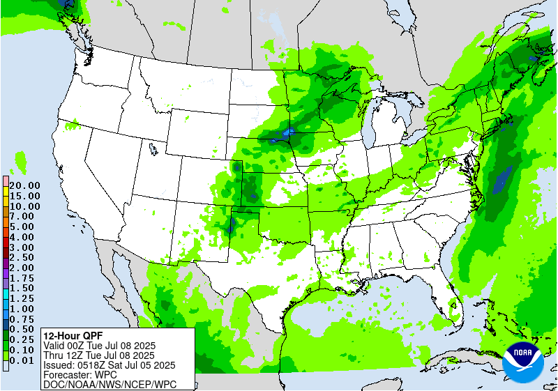
Valid 12Z Mon Jul 07 2025 - 12Z Tue Jul 08 2025
...THERE IS A MARGINAL RISK OF EXCESSIVE RAINFALL FROM THE UPPER
MIDWEST TO THE SOUTHWEST, THE NORTHEAST TO THE OZARK REGION,
PORTIONS OF CENTRAL TEXAS, AND EASTERN NORTH CAROLINA TO
SOUTHEASTERN VIRGINIA...
...Eastern North Carolina and Southeastern Virginia...
The threat for heavy rainfall will continue to decrease, however
some additional heavy amounts are possible as Tropical Cyclone
Three is expected to dissipate over eastern North Carolina.
...Northeast to the Ozark Region...
The previously noted cold front will push across the Northeast
while lingering back across the Ohio into the mid Mississippi
Valley. Overnight models indicate a greater threat for heavy
amounts will focus along with some right-entrance region upper jet
forcing and greater moisture anomalies across northern New England.
However, sufficient moisture is expected to remain in place ahead
of the boundary to support at least localized heavy amounts and an
isolated flooding threat further southeast along and ahead of the
boundary.
...Northern Plains and Upper Midwest...
Models show a well-defined shortwave moving across the region this
period. With plenty of differences in the details, models indicate
some potential for organized heavy rains developing ahead of this
wave as it interacts with an influx of deeper moisture.
...Central Plains to the Southern High Plains/Rockies...
Similar to the previous day, the models are presenting a notable
signal for showers and storms, supported by moist low level inflow,
to develop over High Plains, with some potential for locally heavy
amounts to occur as they move east.
Meanwhile, the coverage of storms and potential flooding concerns
is expected to expand across New Mexico as the monsoon pattern
builds, with moisture increasing across the region.
Pereira
Day 3 threat area:
www.wpc.ncep.noaa.gov/qpf/99epoints.txt
Extended Forecast Discussion
NWS Weather Prediction Center College Park MD
243 AM EDT Sat Jul 5 2025
Showers and thunderstorms are expected to be focused in proximity
to progressive cold fronts, stalled boundaries and round the upper
high in the Southern Rockies. The wavy front into the eastern U.S.
may be a focus for heavier rain and thunderstorms. This includes
areas from the Corn Belt into the Midwest and Ohio Valley,
Appalachians, Mid-Atlantic, and Northeast. There are Marginal Risks
in place (level 1 of 4) for the Southwest, Central Plains/Midwest
to the Upper Mississippi Valley/Upper Great Lakes region and
portions of the Northeast for Day 4 and for the Mid-Mississippi
Valley/Midwest for Day 5.
Heights across the Northeast and Mid-Atlantic regions will
gradually lower as troughing moves in. With the higher heights
shifting southward the heat will increase as well as begin to build
to the west as the upper high strengthens over the Southwest. Many
locations will have daily maximums climbing well into the 100s at
lower elevations which will greatly limit rain except for perhaps
far southeastern AZ into NM early in the week. Experimental
HeatRisk values may rise to Major or Extreme levels (3 out of 4 or
4 out of 4) from the California deserts into southern Nevada, Utah,
and Arizona.
Campbell/Fracasso


