Excessive Rainfall Discussion
NWS Weather Prediction Center College Park MD
855 PM EDT Sun Jun 29 2025
Day 1
Valid 01Z Mon Jun 30 2025 - 12Z Mon Jun 30 2025
...THERE IS A SLIGHT RISK OF EXCESSIVE RAINFALL ACROSS PARTS OF THE
CENTRAL PLAINS AND MIDDLE MISSISSIPPI VALLEY...
01Z Update...
Adjustments made to the previous outlook areas were based largely
on current observations and radar trends. This included the Slight
Risk area over the central Plains, which was shifted a little
further south and pulled west back into portions of northeastern
Oklahoma and eastern Kansas. Radar shows convection developing
along the western flank of the outflow associated with convection
the developed earlier over Missouri. High instability and deep
moisture, supported by southerly flow into the boundary may support
a growing heavy rainfall threat that is not well advertised by the
guidance. This may become the greater heavy rainfall/flash flood
threat, at least in the near term, as guidance does not provide a
strong indication that convection developing over the High Plains
this evening will propagate east back into the same areas over
eastern Kansas and Missouri impacted earlier by heavy rainfall.
Pereira
Previous Discussion...
Late-June weather pattern remains in place
with widely scattered showers/storms and isolated chances for flash
flooding within the warm and humid airmass spanning from the
central U.S. to the Southeast and Mid-Atlantic. Showers and
thunderstorms are expected both along and well- ahead of a cold
front sinking southeastward across the central Plains and Midwest,
a stationary boundary extending from the Mid-Atlantic to the Great
Lakes, as well as associated with diurnal monsoon activity across
the southern Rockies and adjacent High Plains.
Current radar and satellite imagery shows continued thunderstorm
activity from overnight across the eastern central Plains and into
the Mid-Mississippi Valley, producing mostly isolated flooding
concerns and Flash Flood Warnings ongoing across central MO. With
models showing renewed convection later today and tonight across
western Missouri/eastern Kansas that extends northward into
portions if Iowa...the Slight Risk was maintained. This renewed
convection is forecast to be driven by a sinking cold front and
diving upper trough over the north-central U.S.. Precipitable
water values approaching 2" and near the 90th climatological
percentile will provide the opportunity for intense rainfall rates
scattered 2-4" rainfall totals between parts of KS, MO, southern NE
and southern IA. However, given this event is within 12 hours
there remains rather large uncertainty within CAMs on convective
initiation and some may be picking up on morning convection laying
an outflow boundary farther south and limiting northward
development this evening across NE and southern IA or potentially
delaying it until late tonight. Either way, where heavy rain does
overlap with recently saturated soils, scattered flash flooding is
possible.
Elsewhere within the warm sector across the Mid-South, Mid-
Atlantic, Southeast, and Southern Rockies/High Plains, typical
summer thunderstorms exhibiting scattered and a pulse mode are
likely. These storms may contain briefly very intense rainfall
rates, but see updrafts collapse quickly and become outflow
dependent. Where convective clusters merge or linger near a
stationary front draped across the Mid-Atlantic and sensitive
terrain of the central Appalachians, isolated flash flooding is
possible. As always, should these intense and hard to pinpoint
tropical downpours occur over highly urbanized areas, flooding
impacts could become more impactful.
Snell
Day 1 threat area:
www.wpc.ncep.noaa.gov/qpf/94epoints.txt
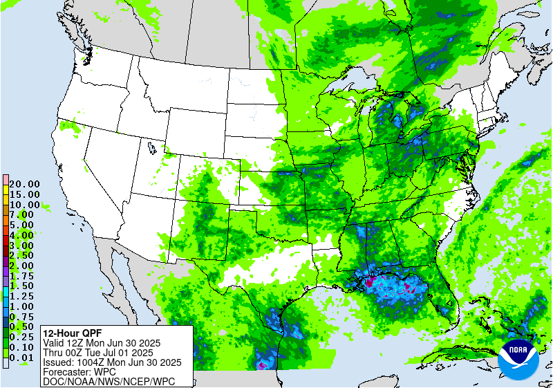
Excessive Rainfall Discussion
NWS Weather Prediction Center College Park MD
428 AM EDT Mon Jun 30 2025
Day 1
Valid 12Z Mon Jun 30 2025 - 12Z Tue Jul 01 2025
...THERE IS A SLIGHT RISK OF EXCESSIVE RAINFALL ACROSS PORTIONS OF
THE CENTRAL/SOUTHERN PLAINS AND THE NEW MEXICO AND WESTERN
TEXAS...
A Slight Risk was maintained across New Mexico and into western
Texas given the presence of a front dropping southward into the
Southern Plains and Southern Rockies...with moist easterly flow
into the complex terrain of the southern Rockies and provide
greater coverage of thunderstorms by the afternoon due to diurnal
heating, increasing lapse rates and instability. Precipitable water
values of 1 inch to 1.5 inches are forecast and will near the 90th
climatological percentile and support rainfall rates of 1-2 inches
per hour. Additionally, widespread coverage of thunderstorm
activity over parts of the Central and High Plains overnight was
accounted for by the introduction of a Slight Risk mainly from
Kansas into Oklahoma this morning before another round of
convection forms over the Southern High Plains along the associated
frontal boundary within an area of very weak mid- level flow later
today. Storms will likely be slow- moving across western Texas and
eastern New Mexico before becoming outflow dependent unless a
large enough cold pool can organize a larger thunderstorm complex.
Elsewhere...convection is expected to develop within a region of
decent CAPE and precipitable water values in excess of 2 standard
deviations above climatology. Except for some mid-level westerly
flow around the Great Lakes to provide some shear there...the flow
farther south should be fairly meager (but offset by steeper low-
level lapse rates). This sets up the potential for some local
rainfall rates in excess of 1 inch per hour that results in
excessive rainfall from the southern Plains east/northeastward into
the Ohio Valley and parts of the Mid- Atlantic region today and
tonight.
Some details are coming into focus, which includes the
likelihood of overnight convection lingering into the early-morning
hours across parts of the central Plains and Mid- Mississippi
Valley. Meanwhile, an upper trough lingering across the Southeast
will continue to foster an area of convergence on the
southern/southwestern periphery which could lead to locally heavy
rainfall along the eastern Gulf Coast and much of the northern
Florida Gulf Coast. There is some potential for extremely heavy
rainfall within this tropical airmass and precipitable water values
between 2.25 inches and 2.5 inches, but the signal from the
numerical guidance is that most rainfall to occur over the Gulf
waters at this time.
Farther north into the Ohio Valley, Appalachians and Northeast, a
weakening surface boundary will help focus some of the threat for
heavier rainfall with its placement remaining quite uncertain. The
synoptic setup with a stationary/warm front stretching across
southern PA and an approaching cold front from the west should help
foster greater coverage in showers/storms within a moist
environment, but storm motions within a mean column wind of 30kts
could limit the flooding threat even though this area remains
sensitive to intense rainfall.
Snell/Bann
Day 1 threat area:
www.wpc.ncep.noaa.gov/qpf/94epoints.txt
Excessive Rainfall Discussion
NWS Weather Prediction Center College Park MD
428 AM EDT Mon Jun 30 2025
Day 2
Valid 12Z Tue Jul 01 2025 - 12Z Wed Jul 02 2025
...THERE IS A SLIGHT RISK OF EXCESSIVE RAINFALL OVER A PORTION OF
THE MID ATLANTIC...
The boundary that helps focus some of the threat for heavy to
potentially excessive rainfall on Day 1 will continue to shift
eastward and provide the focus for another round on Day 2. The
flow aloft becomes more supportive over the Northeast US as
divergence aloft increases in response to a digging trough in the
upper level while convergence is focused at the low-levels
convergence increases along the boundary. Portions of the Mid-
Atlantic have suppressed Flash Flood Guidance from a period of
above normal rainfall making that area a bit more susceptible to
excessive rainfall...while faster cell motions should generally
preclude more than isolated instances of flash flooding across the
Northeast US. The inherited Slight Risk was nudged a bit to the
west of its placement in the previous outlook towards a region of
better overlap between the deterministic QPF and the lower flash
flood guidance. The surrounding Marginal Risk area was changed
little from the previous outlook.
Farther south/west along the boundary...convection is expected to
be develop within a region of decent CAPE and precipitable water
values in excess of 2 standard deviations above climatology. With
weaker flow aloft...locally heavy rainfall totals could result in
isolated instances of excessive rainfall. A stronger push of
moisture is expected into the Four Corners by Tuesday in response
to tropical moisture pushing northwestward across Mexico and
lifting to the east of a closed low churning near the California
coast. This could lead to greater thunderstorm coverage across the
Southwest/Four Corners on Tuesday and a broader isolated flash
flooding threat.
Bann/Snell
Day 2 threat area:
www.wpc.ncep.noaa.gov/qpf/98epoints.txt
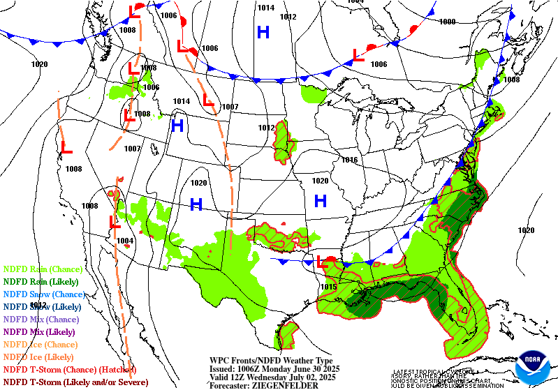
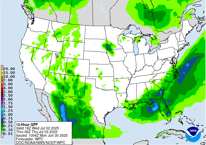
Excessive Rainfall Discussion
NWS Weather Prediction Center College Park MD
428 AM EDT Mon Jun 30 2025
Day 3
Valid 12Z Wed Jul 02 2025 - 12Z Thu Jul 03 2025
...THERE IS A MARGINAL RISK OF EXCESSIVE RAINFALL OVER PORTIONS OF
THE SOUTHEAST US AND ACROSS PARTS OF THE SOUTHERN HIGH PLAINS AND
NEARBY SOUTHERN ROCKIES...
Eastern US...
Drier air sweeping in behind the cold front over the eastern United
States should lead to decreasing coverage of excessive rainfall
potential on Wednesday. Prior to frontal passage...precipitable
water values in excess of 1.75 inches will still be in place and
the atmosphere will be capable of supporting locally intense
rainfall rates. The coastal; portions of the Carolinas and Georgia
will be the last to see the risk taper off.
To the west...a Marginal Risk area was maintained over portions of
the Southern Rockies and adjacent High Plains as deeper moisture
lingers over the area and 850-700 mb flow continues to draw Gulf
moisture northward into West Texas on Wednesday with shortwave
energy embedded within the broad south to southeast flow.
Bann
Day 3 threat area:
www.wpc.ncep.noaa.gov/qpf/99epoints.txt
Extended Forecast Discussion
NWS Weather Prediction Center College Park MD
308 AM EDT Mon Jun 30 2025
Thunderstorms with deep moisture/instability will bring heavy
convective downpours ahead of a upper trough and surface front into
late week for the far Southeast U.S./Florida where WPC Excessive
Rainfall Outlook (ERO) Marginal Risk areas exist Day 4/Thursday
and Day 5/Friday. A focus for multi-day heavy rains may work to
Gulf coastal central Florida where a Slight Risk area continues for
Day 4/Thursday and Day 5/Friday given precursor rains and heavy
rainfall potential given initial right entrance region upper jet
support and anomalous Gulf tropical moisture. Focus may shift
slowly southward over Florida over the weekend.
Monsoonal moisture with some connection to eastern Pacific (T.S.
Flossie) and Bay of Campeche (T.D. Barry) tropical features is
likely to increase coverage and potential of rain amounts into
later this week into the Southwest and southern Rockies/High
Plains on the western periphery of a warming central U.S. upper
ridge. A ERO Marginal Risk area is in place there for Day
4/Thursday, slowly shifting focus to the far southern High Plains
Day 5/Friday. Areas like the Sacramento Mountains, where the steep
terrain and burn scars cause the area to be particularly sensitive
to rain and most vulnerable to potential flash flooding, especially
with wet antecedent conditions there.
Elsewhere, periodic afternoon and nocturnal strong to severe
storms/MCS activity offer heavy rain/runoff potential to focus over
the north-central Plains and Upper Midwest late week into Saturday
as upper trough/impulse energies work over the northern periphery
of the main central U.S. upper ridge as moisture/instability pools
near wavy passing and draping fronts. WPC ERO Marginal Risk areas
have been introduced for Day 4/Thursday and Day 5/Friday. Weekend
to early next week activity with upper system/frontal progressions
then work over the central Midwest/Great Lakes and the Northeast.
Schichtel


