Excessive Rainfall Discussion
NWS Weather Prediction Center College Park MD
855 PM EDT Tue Jul 1 2025
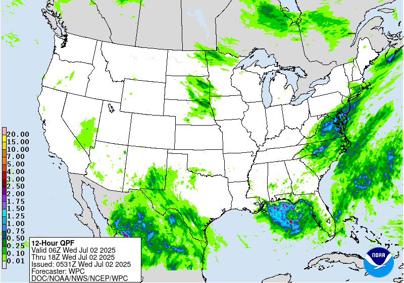
Day 1
Valid 01Z Wed Jul 02 2025 - 12Z Wed Jul 02 2025
..THERE IS A SLIGHT RISK OF EXCESSIVE RAINFALL OVER NORTHERN
PORTIONS OF THE SOUTHEAST AND MID ATLANTIC...
...01Z Update...
With the heaviest rainfall having exited much of the northern Mid-
Atlantic, the Moderate Risk was dropped as of this update. However,
there remain no shortage of rich moisture aloft and modest
instability from the Deep South on north to the Mid-Atlantic
coast. The Slight Risk remains in place for these areas through
tonight. Rainfall gradually tapers off first in the more northern
and western portions of the Marginal and Slight Risk areas this
evening, followed by the more southern and eastern periphery of the
threat areas later tonight. Elsewhere, the Slight Risk in South
Texas was dropped given most hourly rainfall rates are coming in
less than 1"/hr. That said, RAP mesoanalysis still shows a large
area of 2.2-2.4" PWATs throughout South Texas, so opted to maintain
the Marginal Risk given any potential thunderstorms could possibly
muster up >2"/hr rainfall rates. The Marginal Risk was also trimmed
back in parts of southern GA and FL where the localized flash
flood threat is subsiding. Aside from some subtle adjustments via
radar trends and latest 18Z HREF guidance, the Marginal and Slight
Risks in portions of the Southwest and southern High Plains remain
in effect.
Mullinax
---Previous Discussion---
...Northeast through Ohio Valley...
16Z Update: The threat for the Mid Atlantic remains locked in for
the D1 with the MDT risk maintained over the previous areas, but
allowed for an expansion on the northeast flank to encompass all of
the Philadelphia metro, including adjacent areas of Southern NJ.
12z KIAD sounding has come in with a robust 2.07" PWAT, a daily
record for 7/1. The wet bulb zero height is also a daily record
indicating a particularly deep warm-cloud layer situated within the
lower troposphere. This type of environment along with a well-
defined tall, skinny CAPE signature is representative of a strong
prospect for not only heavy rainfall, but significant rate driven
rain cores (2-3+"/hr) that can efficiently drop several inches of
rain in a short span of time. The area encompassing the Central Mid
Atlantic has a variety of factors for enhancing the potential
(urbanization, antecedent moist grounds), but enhanced rates
increase the threat by a respectable margin and historically points
to a higher flash flood threat in both coverage and magnitude for
a period. Recent CAMs are very much depicting several small QPF
maxima littered over the Mid Atlantic with the highest signals
positioned over Northern VA up through the MD Piedmont and points
east-northeast. The alignment of the heavier QPF situated over
Southeast PA into Northern DE and Southern NJ is likely in part to
a targeted convective initiation and training point within a narrow
sheared surface trough situated over the region as noted via the
latest visible sat channels. The assessment this morning only
provided greater credence to the threat with the previous
discussion still well in-play in the overall outline of an elevated
risk for flash flooding. Given some of the latest trends within the
QPF and mesoscale evolution this morning, the MDT risk expansion
through more of Southeast PA into Southern and Central NJ was
generated.
Higher end SLGT risk is now forecast across much of WV as locally
heavy rainfall with potential for up to 2-2.5"/hr rates will likely
cause problems within the complex terrain as funneling effects
tend to exacerbate any convective threat in the state. This threat
extends into far Southwest PA with focus around the periphery of
an advancing MCV currently migrating through Southern OH.
Kleebauer
..Previous Discussion..
Per collaboration with WFOs CTP, PHI, and LWX, we have included a
Moderate Risk to the Day 1 ERO across parts of the northern Mid
Atlantic Region to include NoVa and the DC-Balt metro regions,
northern DE and into southeast PA.
Longwave upper trough over the Upper Great Lakes/Midwest early
this morning will pivot eastward Tue-Tue night, pushing east of the
Appalachians Wed morning. Embedded within the longwave trough is a
shortwave, currently along the IA/IL/MO tri- state area, which
will track across the OH Valley later this afternoon and across the
Mid Atlantic later this evening and overnight. This shortwave
should enhance the broad- scale across the Mid Atlantic region
(especially), while low-level frontogenesis also gets a boost south
of the 90-100kt upper jet streak in the lee of the large-scale
trough.
0-6km bulk shear values increasing to 25+ kts within the inherited
broad Slight Risk area (30-40+ knots over the northern Mid Atlantic
into the Northeast) will support the formation of
widespread/multi-cluster line segments ahead of the upper
trough/surface cold front during peak diurnal instability hours
this afternoon into the evening. MUCAPEs peak between 2000-3000
J/Kg, while TPWs remain around 2 standard deviations above normal
for early July (between 2.00-2.25" within the non-convective
environment across much of the Mid Atlantic into southern New
England). The concern over the Slight and especially Moderate Risk
areas will be with upwind propagation and cell training, as the
pre-frontal southwesterly low-level flow (20-25 kts at 850 mb
becomes nearly parallel and of similar magnitude as the mean
850-300 mb flow. 00Z HREF and RRFS probabilities of 24hr QPF
exceeding 3" climb above 60% within much of the Moderate Risk
area (highest with the RRFS), while probs exceeding 5" within the
24hr period reach 40-60% in spots per the RRFS (though 20-25% tops
per the HREF). Given the favorable thermodynamic profile (high
CAPE/PW environment) along with the broad-scale forcing, anticipate
areas of 2 to 3+ inch/hr rainfall rates this afternoon and evening.
The Moderate Risk area also encompasses areas recently hit by
heavier rainfall, evidenced by the lower FFGs (in some areas, 1 hr
FFGs 1.00" or less). This includes areas SE PA including the
Middletown/Lancaster/Lebanon/Redding areas that received 4-7" of
rain on Monday.
Hurley
...West Texas into New Mexico...
16Z Update: The current SLGT risk was generally maintained with
only a minor expansion to the east to include more of the Western
Rolling Plains adjacent to the Concho Valley. Quasi-stationary
front will be the focal point later this afternoon and evening with
typical diurnal heat flux providing greater buoyancy with the
regional environment allowing for several thunderstorms to develop
in proxy to the boundary. 12z KMAF sounding was right up against
the daily record for PWATs and well beyond the 90th percentile for
the date meaning the environment is ripe for locally heavy precip
potential once the convective regime initiates. 12z HREF probs are
robust for both the neighborhood >2" indicator and the >1" EAS
field which notes a "bullseye" of up to 50% located over parts
of the Upper Trans Pecos into the adjacent Guadalupe Mtns. The
other area of concern will lie within that quasi-stationary front
with a elevated signature for >2" situated from the NM/TX border,
east across the Northern Permian Basin. Enhanced hourly rates will
be the primary threat for the period with 1-2"/hr rates very likely
in any strong convective cores. Look for scattered flash flood
signals within the above zones with the greatest threat positioned
over Southeast NM and adjacent TX Caprock as noted in the QPF/prob
fields.
Kleebauer
..Previous Discussion..
Farther south/west along the stalled frontal boundary...convection
is expected to be develop within a region of decent CAPE and
precipitable water values in excess of 2 standard deviations above
climatology. This area will also benefit from weak upper level
vorticity/shear axis within the broad-scale ridge, with tropical
moisture feeding in per the low-mid layer southeasterly flow.
850-700 mb moisture transport is pretty solid across the outlook
areas, but especially within the Slight Risk region across parts of
West TX into southeast NM where the 850-700 mb moisture flux
standardized anomalies peak between 3-4 standard deviations above
normal per the 00Z SREF and GEFS. Given the relatively healthy
low-level flow compared to the overall weaker mean flow, areas of
heavy, possibly excessive rainfall are anticipated, especially
within the Slight Risk area, considering the uptick in upwind
propagation and thus chances for cell training.
Hurley
...South Texas...
16Z Update: Only minor adjustments necessary for the SLGT risk
across Deep South TX as the previous forecast remains on track.
Little deviation in the prob fields from overnight allowed for a
continuation of the SLGT risk with emphasis on greatest threat
likely over the Lower RGV, including the cities of Brownsville and
McAllen.
Kleebauer
..Previous Discussion..
An influx of abnormally high TPW from the remnants of Tropical
Cyclone Barry (2.2 to 2.4", which is close to 3 standard
deviations above normal for early July) will combine with a
modestly unstable environment (MUCAPEs increasing to 1500-2500
J/Kg) in producing very heavy short-term rainfall rates later this
afternoon/evening and potentially later into the overnight period.
Both the HREF and RRFS ensembles show high probabilities (>50%) of
3+ inch rainfall, with 30-40% probs of exceeding 5 inches.
Therefore expect more than a localized risk of flash flooding
(i.e. Slight vs Marginal) across portions of South Texas from
Corpus Christi south through Brownsville and the RGV.
Hurley
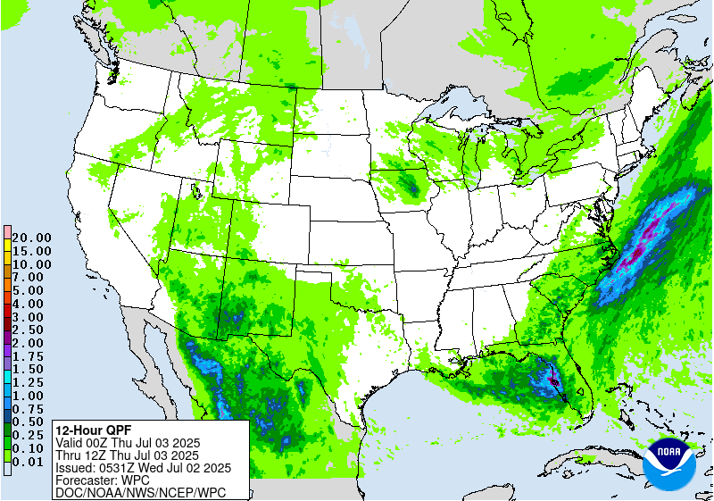
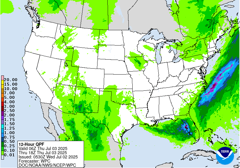
Day 1 threat area:
www.wpc.ncep.noaa.gov/qpf/94epoints.txt
Excessive Rainfall Discussion
NWS Weather Prediction Center College Park MD
855 PM EDT Tue Jul 1 2025
Day 2
Valid 12Z Wed Jul 02 2025 - 12Z Thu Jul 03 2025
...THERE IS A SLIGHT RISK OF EXCESSIVE RAINFALL ACROSS PORTIONS OF
SOUTHEAST VIRGINIA AND NORTHEAST NORTH CAROLINA, WESTERN FLORIDA
COAST, AND THE SOUTHWESTERN U.S...
...Lower Mid Atlantic and Southeast...
20Z Update: The combination of elevated moisture on the order of
+1 to +2 deviation PWATs, relevant buoyancy, modest shear, and the
progression of a cold front from the northwest will aid in
sufficient convergence in-of the VA Tidewater down through Eastern
NC on Wednesday. PWATs encroaching 2.2-2.4" across the above region
will setup an environment capable of not only heavy rainfall, but
efficient warm rain processes that should maximize QPF in any
convective cores that materialize. 12z CAMs continue to depict
forecast soundings over the Southeast Mid Atlantic coast that
exhibit textbook tall, skinny CAPE signatures with a deep moisture
layer sampled from the surface to tropopause. 12z HREF neighborhood
probs for >3" were running between 70-90% over the area extending
from Williamsburg, VA down through Morehead City, NC with >5"
probs hovering between 25-40% with a bullseye of 50-60% over the
Hampton Roads area of Southeast VA. These signals are indicative of
locally heavy rainfall likely with an areal average of 1-2", at
the very least within the ensemble means. This allowed for a
general maintenance of the SLGT risk inherited with some minor
expansions to cover for the latest HREF blended mean QPF footprint.
Scattered heavy convection will also be forecast away from the
above area with the main threat likely more urbanized flash flood
concerns within any heavier cells as the environment is ripe for
locally heavy rainfall from the Central Gulf coast to points north
and northeast.
...Southwest...
20Z Update: Synoptic progression across the Southwestern CONUS
coupled with a deep, moist advection pattern further inland from
the southeast will lead to widespread convective development across
West TX, extending westward through the terrain of NM and AZ. A
stagnant upper trough/ULL centered off the CA coast will meander
over the next 24 hrs to the east before finally pushing further
inland and opening up into quite a prolific trough providing large
scale ascent to much of the Desert Southwest east of the Colorado
river basin. Presence of monsoonal moisture will be amplified
moving into Wednesday as the amplified flow from the approaching
trough and ridge positioning over the Four Corners will create the
textbook funneling affect of deeper moisture poleward through West
TX to points north and northwest. The highest PWAT anomalies will
be centered over Southeast NM, Southern NM, and the Mogollon Rim
creating a generally buoyant environment over the aforementioned
areas. With MUCAPE between 1000-2500 J/kg and PWAT anomalies ~2
deviations above normal as depicted via the ECENS and NAEFS
outputs, expectation is for scattered heavy convective cores
capable of hourly rates approaching 1"/hr with generally slow cell
motions leading to some training concerns across the terrain. 12z
HREF 24hr ARI exceedance probabilities are between 40-70% for
exceeding 10yr intervals and 10-30% for even some 100yr ARI
threats, a testament to the expected magnitude of precip falling
during the period. Locally 1-2" of rainfall within the area is
plenty to cause significant flash flood issues in any one area
across the Sacramento's through the terrain west and northwest.
There is enough evidence given the expected environment and
widespread convective regime for a broad SLGT risk positioned
across El Paso, Southern NM, Southeast AZ, and the Mogollon Rim
across Central AZ.
...Western Florida Coast...
20Z Update: The combination of a slow-moving frontal progression
and potential for weak surface reflection over the Eastern Gulf
will create a period of unsettled weather in-of the Western FL
Peninsula. The prospects for heavy rainfall capable of widespread
flash flood concerns is still on the lower end with the best threat
relegated to the urban zones along the coast with the best threat
likely over western Pasco and Hillsborough counties, along with
Pinellas county where the Tampa metro is the center of where the
threat lies. When assessing the hi-res guidance today, you would
think there's a chance of 10+ inches of rainfall along the coast,
but a lot of that precip stems from the CAMs struggling with the
surface reflection and likely enhancing the baroclinicity along the
front, an issue that has cropped up in the past. Other
deterministic members within the global suite are closer to 4-7"
for maxima with ensemble depiction closer to the lower end of the
range. This is subjective to a multitude of factors ranging from
frontal positioning, surface convergence, location of the low
proxy, and other finer mesoscale details. At the current look, the
threat is still within the threshold of higher risk, but low to
medium confidence considering some of the finer details. At this
juncture, with the PWATs and focal point necessary for locally
enhanced rainfall potential with rates pushing 3-5"/hr in stronger
cells in any location, and the urbanization concerns where the
heaviest rain will fall, a SLGT risk was added to the three
counties inferred above with the Tampa/Clearwater/St. Petersburg
metro the area of greatest concern. Will be a period to monitor for
shifts in the risk level, whether downgrade or upgrade.
Kleebauer
Day 2 threat area:
www.wpc.ncep.noaa.gov/qpf/98epoints.txt
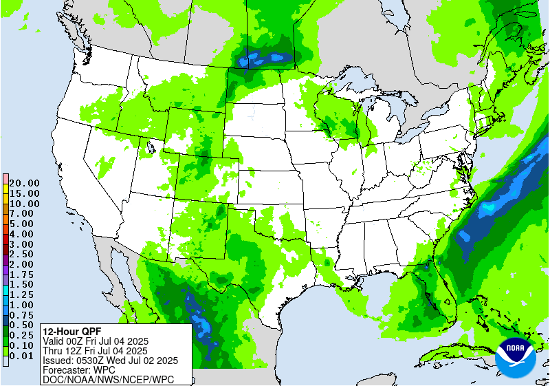
Excessive Rainfall Discussion
NWS Weather Prediction Center College Park MD
855 PM EDT Tue Jul 1 2025
Day 3
Valid 12Z Thu Jul 03 2025 - 12Z Fri Jul 04 2025
...THERE IS A SLIGHT RISK OF EXCESSIVE RAINFALL ACROSS WESTERN
PORTIONS OF THE FLORIDA PENINSULA...
...Florida and Georgia...
20Z Update: Little changes was necessary for the SLGT risk across
the western FL coast as the previous forecast remains on track.
This period has the best consistency in the positioning and
magnitude of the heavy precip threat among the deterministic. As of
now, the risk is lower in terms of magnitude compared to what could
transpire in the D2, so the threat could be downgraded if the
previous periods doesn't materialize. However, overlap if the
threat D2 transpires would ultimately create a greater threat, so
some of the threat could be contingent on the evolution. ML is
consistent in its interpretation of the heavier rain positioned
between Clearwater down to Ft. Myers, so it's worth noting we have
a good signal for the location. It will be worth monitoring in the
coming days with plenty of time for any adjustments.
Kleebauer
..Previous Discussion..
Subtle changes were made to the Slight and Marginal Risk areas
inherited from yesterday's Day 4 ERO. Southern periphery of the
longwave upper trough crosses the area Thu-Thu night, with the
guidance showing embedded shortwaves (possibly convectively-
enhanced) reaching South FL toward the end of the period (12Z Fri).
Ahead of the nearly stationary surface front, onshore west to
southwest low-level inflow from the eastern Gulf will likely lead
to a more focused area of low-level moisture transport/flux
convergence over much of the west coast of FL, especially north of
Ft. Myers to include the Tampa-St. Pete area, where 0-6km bulk
shear values do approach 25 kts (allowing for more
organized/widespread convective clusters). The RRFS is most
particularly robust with the QPF within the Slight Risk area (areas
of 3-6+ inches), which considering the thermodynamic
environment/deep subtropical moisture (TPW values 2.25 to 2.50"),
is certainly plausible. Especially considering the onshore low-
level inflow will likely exceed (perhaps double) the mean 850-300
mb wind), enhancing the potential for cell training. Even with a
more limited (tall/skinny) CAPE profile, sub-hourly rainfall rates
of 2.5-3.0+ inches within this environment will be possible,
especially within the Slight Risk area.
Hurley
...Southern Plains to Southwest...
Continued deep moist advective pattern will lead to scattered or
even widespread thunderstorm activity over much of West TX up
through the Central Rockies as the upstream synoptic evolution of
the ejecting trough will create a pretty robust large scale ascent
signature across much of the CONUS west of the 100W marker. Still
some discrepancy on the eastern expansion of the heavier convective
threat with some guidance inferring the Concho Valley, others the
Permian Basin and Trans Pecos, and others as far west as Southwest
TX. Too much spread in the deterministic with the ensemble means
relatively modest in magnitude. As we move into CAMs range, expect
the signal to ramp up in the magnitude with a more defined axis of
heavy precip likely to allow for a targeted SLGT risk. Areas within
the Central Rockies will be evaluated in the coming days as well
with the core of the shortwave energy ejecting out of the
Southwest likely to motion overhead. This could be a target for
heavy rain prospects along the Southern Laramie Range down through
the Foothills of CO Rockies with some guidance depicting 2-3" of
rainfall in the period, something that could also spur an upgrade
in the risk with the environment in place. For now, a broad MRGL
risk encompasses much of the Southwest, Southern Plains, and
Central Rockies.
Kleebauer
Day 3 threat area:
www.wpc.ncep.noaa.gov/qpf/99epoints.txt
Extended Forecast Discussion
NWS Weather Prediction Center College Park MD
259 PM EDT Tue Jul 1 2025
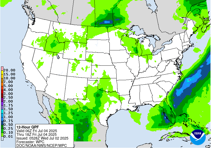
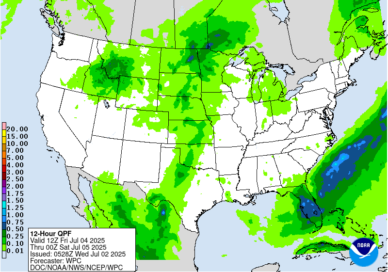
Thunderstorms within deep tropical moisture and instability will
support heavy convective downpours along/south of a lingering and
slow-to-dissipate front across Florida through the upcoming holiday
weekend. WPC Excessive Rainfall Outlook (ERO) Marginal Risk areas
are in place for Day 4/Friday and Day 5/Saturday in a region across
west-central Florida Peninsula preceded by heavy rains and
anomalous Gulf tropical moisture. Latest guidance has continued to
back off on explicit QPF amounts despite a favorable pattern
feeding off the eastern Gulf where the NHC has been monitoring for
the potential of tropical cyclone formation.
Monsoonal moisture with some connection to current eastern Pacific
Hurricane Flossie and some Gulf moisture from recent Barry may
boost rain potential that may linger into Friday over the Big
Bend and vicinity. Model guidance has generally backed off on
the QPF amounts.
Periodic afternoon and nocturnal strong to severe storms/MCS
activity offer heavy rain/runoff potential to focus from the
north-central Plains to the upper Midwest late week into Saturday
as upper trough/impulse energies work over the northern periphery
of the main central U.S. upper ridge where moisture/instability
tends to be lifted near a wavy draping front. WPC ERO Marginal
Risk areas have been maintained for Day 4/Friday and Day
5/Saturday. From the weekend to early next week, showers and
embedded thunderstorms could refire across the north-central states
where ejection of upper-level shortwaves from the northern Rockies
will interact with the wavy frontal zone which could lead to
locally enhanced rainfall in portions of the northern High Plains
to the northern Plains. Meanwhile, a wave of heat and humidity
is expected to spread from west to east across the northern tier
states including the Ohio Valley and mid-Atlantic through the
holiday weekend around the upper ridge.
Kong/Schichtel
Extended Forecast Discussion
NWS Weather Prediction Center College Park MD
259 PM EDT Tue Jul 1 2025
Thunderstorms within deep tropical moisture and instability will
support heavy convective downpours along/south of a lingering and
slow-to-dissipate front across Florida through the upcoming holiday
weekend. WPC Excessive Rainfall Outlook (ERO) Marginal Risk areas
are in place for Day 4/Friday and Day 5/Saturday in a region across
west-central Florida Peninsula preceded by heavy rains and
anomalous Gulf tropical moisture. Latest guidance has continued to
back off on explicit QPF amounts despite a favorable pattern
feeding off the eastern Gulf where the NHC has been monitoring for
the potential of tropical cyclone formation.
Monsoonal moisture with some connection to current eastern Pacific
Hurricane Flossie and some Gulf moisture from recent Barry may
boost rain potential that may linger into Friday over the Big
Bend and vicinity. Model guidance has generally backed off on
the QPF amounts.
Periodic afternoon and nocturnal strong to severe storms/MCS
activity offer heavy rain/runoff potential to focus from the
north-central Plains to the upper Midwest late week into Saturday
as upper trough/impulse energies work over the northern periphery
of the main central U.S. upper ridge where moisture/instability
tends to be lifted near a wavy draping front. WPC ERO Marginal
Risk areas have been maintained for Day 4/Friday and Day
5/Saturday. From the weekend to early next week, showers and
embedded thunderstorms could refire across the north-central states
where ejection of upper-level shortwaves from the northern Rockies
will interact with the wavy frontal zone which could lead to
locally enhanced rainfall in portions of the northern High Plains
to the northern Plains. Meanwhile, a wave of heat and humidity
is expected to spread from west to east across the northern tier
states including the Ohio Valley and mid-Atlantic through the
holiday weekend around the upper ridge.
Kong/Schichtel


