Excessive Rainfall Discussion
NWS Weather Prediction Center College Park MD
857 PM EDT Sat Jun 28 2025
Day 1
Valid 01Z Sun Jun 29 2025 - 12Z Sun Jun 29 2025
...THERE IS A SLIGHT RISK OF EXCESSIVE RAINFALL ACROSS PORTIONS OF
SOUTH-CENTRAL MISSOURI AND NORTH-CENTRAL ARKANSAS...
01Z Update...
Maintained outlooks in all four areas, with some adjustments based
on radar trends and recent hi-res guidance. The biggest adjustment
was to expand the Marginal Risk area over the southern High Plains
farther north and east to include ongoing convection along the
southeastern NM/northwestern TX border. Otherwise, made only minor
adjustments to the previous outlook areas, including the Slight
Risk centered over southern Missouri and northern Arkansas.
Pereira
Previous Discussion...
...Middle/Lower Mississippi Valley and adjacent southern
Plains, Ohio and Tennessee valleys...
Firmly in the warm sector and within a moist airmass containing
widespread PWATs of 1.8-2.2" (near the 90th climatological
percentile), isolated to scattered flash flooding is possible
today with a potentially higher focus across parts of southern MO
and northern AR tonight, where a Slight Risk of Excessive Rainfall
was introduced in the 16z update. An MCV evident on morning radar
and satellite imagery has already prompted a few FFWs across
eastern OK and KS while gradually pushing eastward. This feature
will aid in sparking widely scattered slow- moving thunderstorms
throughout the afternoon while instability levels rise due to
diurnal heating. Pulse thunderstorms within weak steering flow and
an unstable/moist environment are also likely through much of the
Ohio and Tennessee valleys today, with smaller scale scattered
flash flooding possible. Current trends are for the aforementioned
MCV to make it into the vicinity of southeast MO by late tonight
and influence a sharp mid-level trough ahead of increasing warm air
advection throughout the Plains due to a crossing shortwave in the
north- central U.S. and the nighttime low- level jet. CAMs still
differ somewhat in the exact location of a potential northwest-
southeast oriented band of slow-moving storms, but generally
converge on south-central MO and don't really develop until around
09z tonight. The 12z HREF has increased 24-hr probs (12z Sat-12z
Sun) for greater than 5" of rain to 30-45% within the Slight Risk
outline. Additionally, this part of the country also has relatively
saturated soils already (70-100% 0-40 cm below ground relative
soil moisture percentiles per NASA SPoRT) not including the
likelihood of scattered thunderstorms and potentially overlapping
heavy rainfall this afternoon.
...Northern Plains and Upper Midwest...
Showers and thunderstorms capable of producing locally heavy
rainfall rates and heavy rainfall totals have the potential to
produce flash flooding as the next upper shortwave trough
approaches the north-central United States. Aided by a 90kt upper
level jet streak on the lee side...the upper trough will generate a
compact area of fairly robust, transient deep-layer forcing over
the outlook area later today and tonight. MUCAPEs are expected to
soar within the warm sector prior to the surface cold frontal
passage late tonight. Given precipitable water values getting near
1.75 inches...storms which form within the unstable airmass will
be capable of producing rainfall rates in excess 1.5"/hr and areal
average rainfall amounts of 1 to 3 inches...especially once low-
level inflow accelerates to between 30 kts and 40kts at 850 mb
ahead of the approaching front. The storm/mesoscale nature of the
threat leads to uncertainty of a more focused corridor of higher
risk, but a Slight Risk was considered in central MN where forward
propagation of storms may begin slow this evening and is reinforced
by the highest 12z HREF probs (20-30%) for exceeding 3" in 6 hours.
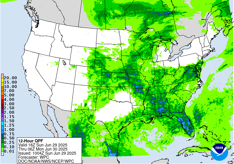
...Central Appalachians to the Northeast...
There continues to be a concern for heavy to potentially excessive
rainfall to develop across western Pennsylvania and surrounding
areas as the frontal boundary sags southward and taps into the
pooled PW values of 1.5-2". 12z CAMs are not a robust with rainfall
amounts in the central Appalachians and keep things moving along in
the Northeast to limit any flash flooding to isolated instances.
However, the environment remains unstable and moist, so any slow-
moving storms could lead to forming mesoscale boundaries that
create locally intense rainfall. Farther north, the Marginal Risk
was removed across northern New England given unimpressive radar
trends this morning and a more progressive patter. Still, 1-1.5" of
rainfall could lead to very isolated and more nuisance flooding.
...Southeast and central Florida Peninsula...
Scattered pulse thunderstorms are expected across a broad warm
sector and near an upper trough lingering over the region as
seasonable instability develops with daytime heating. A greater
focus for intense rainfall also overlaps with higher FFG across
the central Gulf Coast and Florida Peninsula, where rainfall rates
of 2-3"/hr are possible but should weaken quickly before
convection is driven off outflow from numerous other pop-up storms.
...New Mexico...
Yet another day of thunderstorms is expected across portions of
southern New Mexico and west Texas with locally heavy rainfall
(1-2") possible. QPF trends (coverage, intensity) are more isolated
compared prior days with the moist south to southeast low-level
upslope flow likely resulting in more localized areas of heavier
rainfall focused across the Sacramento and Guadalupe Mtns south
through the Trans-Pecos. The flash flood potential is expected to
remain isolated.
Snell
Day 1 threat area:
www.wpc.ncep.noaa.gov/qpf/94epoints.txt
Excessive Rainfall Discussion
NWS Weather Prediction Center College Park MD
428 AM EDT Sun Jun 29 2025
Day 1
Valid 12Z Sun Jun 29 2025 - 12Z Mon Jun 30 2025
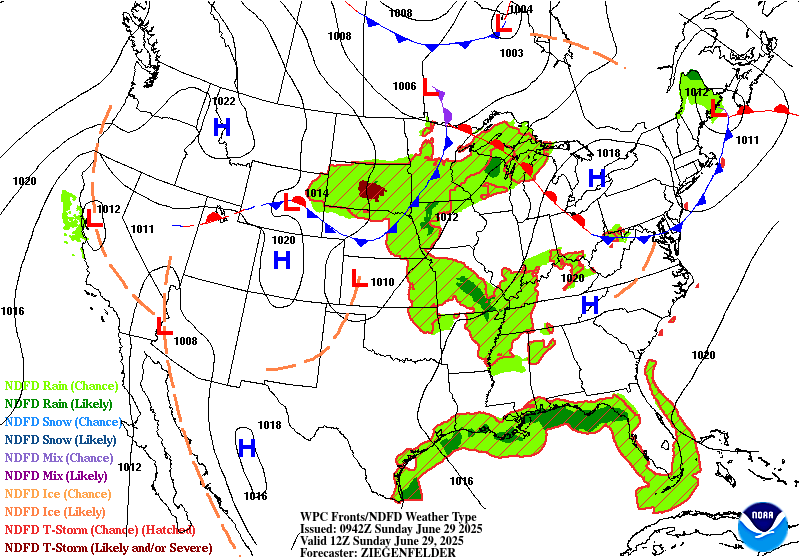
...THERE IS A MARGINAL RISK OF EXCESSIVE RAINFALL EXTENDING FROM
PORTIONS OF THE CENTRAL UNITED STATES TO THE CENTRAL GULF COAST AND
MID-ATLANTIC...
Late-June weather pattern remains in place on Sunday with widely
scattered showers/storms and isolated chances for flash flooding
within the warm and humid airmass spanning from the central U.S. to
the Southeast and Mid-Atlantic. Showers and thunderstorms are
expected both along and well- ahead of a cold front sinking
southeastward across the central Plains and Midwest, as well as
associated with diurnal monsoon activity across the southern
Rockies and adjacent High Plains.
As Day 1 begins, late-night convection lingering across parts of
Missouri should be about to fade with the weakening of a low level
jet. With models showing renewed convection later today and tonight
across western Missouri/eastern Kansas that extends northward into
portions if Iowa...did introduce a Slight Risk area to the
outlook where organized convection from overnight approached the
area from the north. Precipitable water values approaching 2" and
near the 90th climatological percentile will provide the
opportunity for intense rainfall rates scattered 2-4" rainfall
totals between parts of KS, MO, and southern IA.
Elsewhere within the warm sector across the Mid-South, Mid-
Atlantic, Southeast, and Southern Rockies/High Plains, typical
summer thunderstorms exhibiting scattered and a pulse mode are
likely. These storms may contain briefly very intense rainfall
rates, but see updrafts collapse quickly and become outflow
dependent. Where convective clusters merge or linger near a
stationary front draped across the Mid-Atlantic and central
Appalachians, isolated flash flooding is possible.
Bann/Snell
Day 1 threat area:
www.wpc.ncep.noaa.gov/qpf/94epoints.txt
Excessive Rainfall Discussion
NWS Weather Prediction Center College Park MD
428 AM EDT Sun Jun 29 2025
Day 2
Valid 12Z Mon Jun 30 2025 - 12Z Tue Jul 01 2025
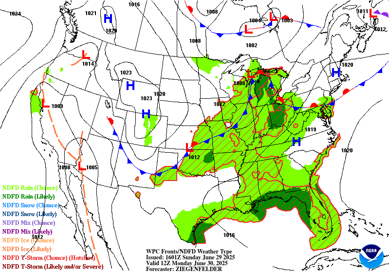
...THERE IS A MARGINAL RISK OF EXCESSIVE RAINFALL ACROSS PORTIONS
OF THE SOUTHERN ROCKIES EASTWARD INTO THE MID ATLANTIC...
Similar to today...convection is expected to develop within a
region of decent CAPE and precipitable water values in excess of 2
standard deviations above climatology. Except for some mid-level
westerly flow around the Great Lakes to provide some shear
there...the flow farther south should be fairly meager (but offset
by steeper low-level lapse rates). This sets up the potential for
some local rainfall rates in excess of 1 inch per hour that results
in excessive rainfall from the Southern Rockies/Western High
Plains east/northeastward into the Ohio Valley and parts of the
Mid-Atlantic region on Monday and Monday night.
A weakening surface boundary will help focus some of the threat
for heavier rainfall but its placement remains quite uncertain.
One area that is still being monitored for a potential upgrade to a
Slight Risk are parts of the Upper Ohio Valley and central
Appalachians (centered over western PA). The synoptic setup with a
stationary/warm front stretching across southern PA and an
approaching cold front from the west should help foster greater
coverage in showers/storms within a moist environment, but storm
motions within a mean column wind of 30kts could limit the flooding
threat even though this area remains sensitive to intense
rainfall. Therefore, a Marginal Risk was maintained to highlight
the threat for isolated flash flooding.
Snell/Bann
Day 2 threat area:
www.wpc.ncep.noaa.gov/qpf/98epoints.txt
Excessive Rainfall Discussion
NWS Weather Prediction Center College Park MD
428 AM EDT Sun Jun 29 2025
Day 3
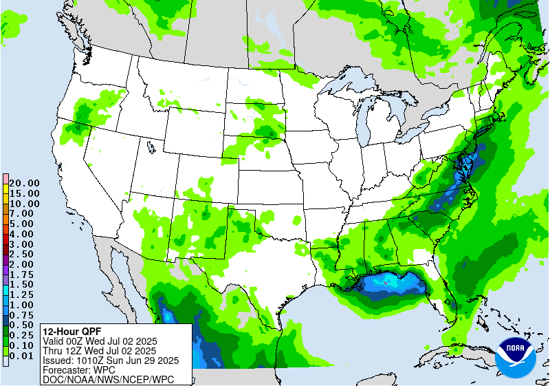
Valid 12Z Tue Jul 01 2025 - 12Z Wed Jul 02 2025
...THERE IS A SLIGHT RISK OF EXCESSIVE RAINFALL OVER A PORTION OF
THE MID ATLANTIC...
The boundary that helps focus some of the threat for heavy to
potentially excessive rainfall on Day 2 will continue to shift
eastward and provide the focus for another round on Day 3.
The flow aloft becomes more supportive over the Northeast US as
divergence aloft increases in response to a digging trough aloft
and low level convergence increases along the boundary. Portions
of the Mid-Atlatic have suppressed Flash Flood Guidance from a
period of above normal rainfall making that area a bit more
susceptible to excessive rainfall...while faster cell motions
should preclude more than isolated instances of flash flooding
across the Northeast US.
Farther south/west along the boundary...convection is expected to
be develop within a region of decent CAPE and precipitable water
values in excess of 2 standard deviations above climatology. With
weaker flow aloft...locally heavy rainfall totals could result in
isolated instances of excessive rainfall.
Bann
Day 3 threat area:
www.wpc.ncep.noaa.gov/qpf/99epoints.txt


