Excessive Rainfall Discussion
NWS Weather Prediction Center College Park MD
427 PM EDT Mon Jun 30 2025
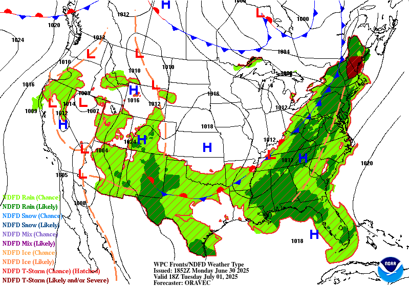
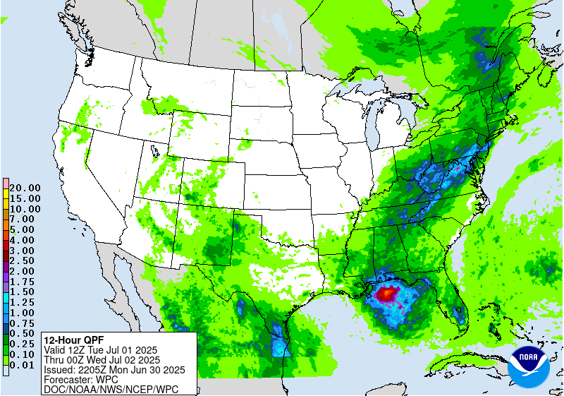
Day 1
Valid 16Z Mon Jun 30 2025 - 12Z Tue Jul 01 2025
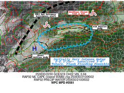
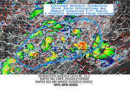
...16Z Update...
Main changes to the overnight forecast include the introduction of a
Slight Risk over portions of the eastern Ohio Valley, Central
Appalachians, and Upper Mid-Atlantic. 12Z sounding data across the
region highlights a very moist and unstable airmass (PWATS at or
above the daily max for PIT and IAD) in the vicinity of a slow
moving warm front. Showers and thunderstorms are forecast to expand
in coverage today with continued heating, which will be capable of
very efficient subhourly rainfall rates which could breach flash
flood guidance in spite of generally progressive storm motions.
Otherwise, the Slight Risk was trimmed in the Central/Southern
Plains in the wake of an overnight MCS which has sent a strong cold
pool southward. The main area of concern will focus along this
boundary later today, over portions of Central Oklahoma and Eastern
Arkansas into the Red River.
Asherman
...THERE IS A SLIGHT RISK OF EXCESSIVE RAINFALL ACROSS PORTIONS OF
THE CENTRAL/SOUTHERN PLAINS AND THE NEW MEXICO AND WESTERN
TEXAS...
A Slight Risk was maintained across New Mexico and into western
Texas given the presence of a front dropping southward into the
Southern Plains and Southern Rockies...with moist easterly flow
into the complex terrain of the southern Rockies and provide
greater coverage of thunderstorms by the afternoon due to diurnal
heating, increasing lapse rates and instability. Precipitable water
values of 1 inch to 1.5 inches are forecast and will near the 90th
climatological percentile and support rainfall rates of 1-2 inches
per hour. Additionally, widespread coverage of thunderstorm
activity over parts of the Central and High Plains overnight was
accounted for by the introduction of a Slight Risk mainly from
Kansas into Oklahoma this morning before another round of
convection forms over the Southern High Plains along the associated
frontal boundary within an area of very weak mid- level flow later
today. Storms will likely be slow- moving across western Texas and
eastern New Mexico before becoming outflow dependent unless a
large enough cold pool can organize a larger thunderstorm complex.
Elsewhere...convection is expected to develop within a region of
decent CAPE and precipitable water values in excess of 2 standard
deviations above climatology. Except for some mid-level westerly
flow around the Great Lakes to provide some shear there...the flow
farther south should be fairly meager (but offset by steeper low-
level lapse rates). This sets up the potential for some local
rainfall rates in excess of 1 inch per hour that results in
excessive rainfall from the southern Plains east/northeastward into
the Ohio Valley and parts of the Mid- Atlantic region today and
tonight.
Some details are coming into focus, which includes the
likelihood of overnight convection lingering into the early-morning
hours across parts of the central Plains and Mid- Mississippi
Valley. Meanwhile, an upper trough lingering across the Southeast
will continue to foster an area of convergence on the
southern/southwestern periphery which could lead to locally heavy
rainfall along the eastern Gulf Coast and much of the northern
Florida Gulf Coast. There is some potential for extremely heavy
rainfall within this tropical airmass and precipitable water values
between 2.25 inches and 2.5 inches, but the signal from the
numerical guidance is that most rainfall to occur over the Gulf
waters at this time.
Farther north into the Ohio Valley, Appalachians and Northeast, a
weakening surface boundary will help focus some of the threat for
heavier rainfall with its placement remaining quite uncertain. The
synoptic setup with a stationary/warm front stretching across
southern PA and an approaching cold front from the west should help
foster greater coverage in showers/storms within a moist
environment, but storm motions within a mean column wind of 30kts
could limit the flooding threat even though this area remains
sensitive to intense rainfall.
Snell/Bann
Day 1 threat area:
www.wpc.ncep.noaa.gov/qpf/94epoints.txt
Excessive Rainfall Discussion
NWS Weather Prediction Center College Park MD
427 PM EDT Mon Jun 30 2025
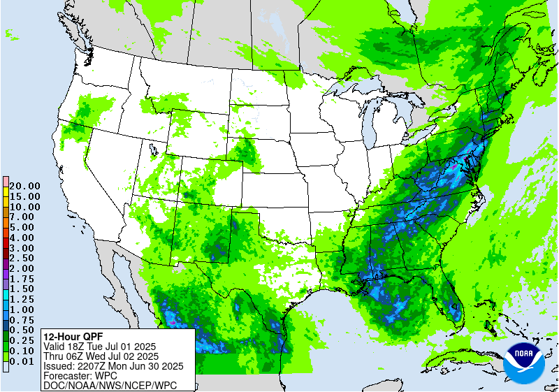
Day 2
Valid 12Z Tue Jul 01 2025 - 12Z Wed Jul 02 2025
...THERE IS A SLIGHT RISK OF EXCESSIVE RAINFALL OVER A PORTION OF
THE MID ATLANTIC AND NORTHEAST...
...2030Z Update...
The Slight Risk was expanded across the Mid-Atlantic and Northeast
ahead of the cold front. Thunderstorms across the region today are
expected to "prime" soils across the region, which are already well
above average according to NASA SPoRT 0-40 cm soil moisture
percentiles. By early tomorrow afternoon, slow moving cold front
and right entrance region ascent are forecast to drive widespread
thunderstorms within an airmass characterized by PWAT values in the
97-99th percentile per the NAEFS. While individual cell motions
will likely be progressive (15-30 kts), steering flow oriented
parallel to the forcing should favor periods of cell training and
repeating ahead of the cold front. Both the 12Z HREF and REFS
neighborhood probabilities highlight a high (60-90%) chance of 24
hour QPF exceeding three inches across the area, with embedded 30-40%
maxima of at least five inches noted. Considerable to locally
significant flash flooding is possible tomorrow within sensitive
urban areas along the I-95 corridor, and over complex terrain in
the Appalachians.
Asherman
...PREVIOUS DISCUSSION...
The boundary that helps focus some of the threat for heavy to
potentially excessive rainfall on Day 1 will continue to shift
eastward and provide the focus for another round on Day 2. The
flow aloft becomes more supportive over the Northeast US as
divergence aloft increases in response to a digging trough in the
upper level while convergence is focused at the low-levels
convergence increases along the boundary. Portions of the Mid-
Atlantic have suppressed Flash Flood Guidance from a period of
above normal rainfall making that area a bit more susceptible to
excessive rainfall...while faster cell motions should generally
preclude more than isolated instances of flash flooding across the
Northeast US. The inherited Slight Risk was nudged a bit to the
west of its placement in the previous outlook towards a region of
better overlap between the deterministic QPF and the lower flash
flood guidance. The surrounding Marginal Risk area was changed
little from the previous outlook.
Farther south/west along the boundary...convection is expected to
be develop within a region of decent CAPE and precipitable water
values in excess of 2 standard deviations above climatology. With
weaker flow aloft...locally heavy rainfall totals could result in
isolated instances of excessive rainfall. A stronger push of
moisture is expected into the Four Corners by Tuesday in response
to tropical moisture pushing northwestward across Mexico and
lifting to the east of a closed low churning near the California
coast. This could lead to greater thunderstorm coverage across the
Southwest/Four Corners on Tuesday and a broader isolated flash
flooding threat.
Bann/Snell
Day 2 threat area:
www.wpc.ncep.noaa.gov/qpf/98epoints.txt
Excessive Rainfall Discussion
NWS Weather Prediction Center College Park MD
427 PM EDT Mon Jun 30 2025
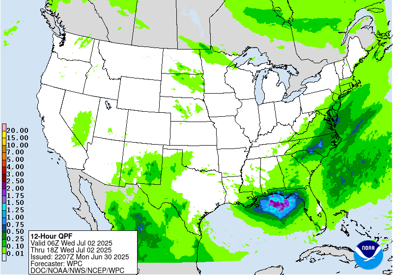
Day 3
Valid 12Z Wed Jul 02 2025 - 12Z Thu Jul 03 2025
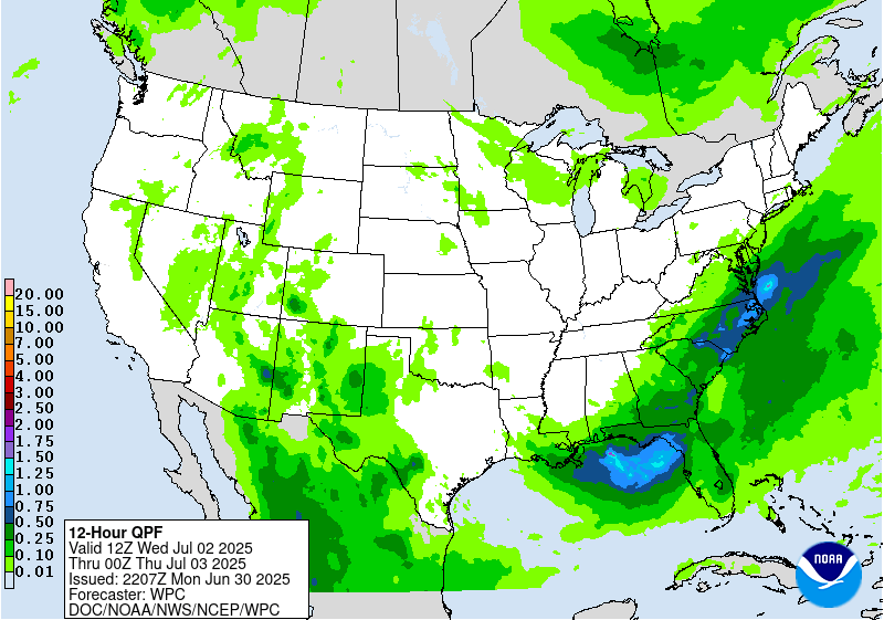
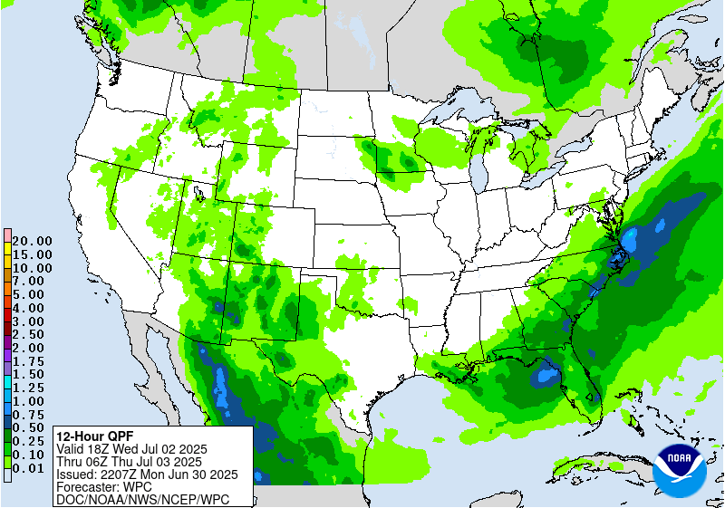
...THERE IS A MARGINAL RISK OF EXCESSIVE RAINFALL OVER PORTIONS OF
THE SOUTHEAST US AND ACROSS PARTS OF THE SOUTHERN HIGH PLAINS AND
NEARBY SOUTHERN ROCKIES...
...2030Z Update...
Generally minor adjustments made to the overnight forecast,
including an expansion of the Marginal Risk into parts of the Mid-
Atlantic. Lingering heavy rainfall potential will remain as the
front slowly presses southeastward, driving additional showers and
thunderstorms with 90th percentile PWATs which could overlap with
heavy rainfall from days 1-2.
The Marginal was also expanded in the Southern Rockies based on the
uptick in QPF as an upper-trough approaches from the west, while
southeasterly flow ushers in 97th-99th percentile PWATs into the
region.
Asherman/Bann
Day 3 threat area:
www.wpc.ncep.noaa.gov/qpf/99epoints.txt
Extended Forecast Discussion
NWS Weather Prediction Center College Park MD
244 PM EDT Mon Jun 30 2025
Thunderstorms with deep moisture/instability will bring heavy
convective downpours ahead of a upper trough and surface front into
late week for the far Southeast U.S./Florida where WPC Excessive
Rainfall Outlook (ERO) Marginal Risk areas exist Day 4/Thursday
and Day 5/Friday. A focus for multi-day heavy rains may work to
Gulf coastal central Florida where a Slight Risk area continues for
Day 4/Thursday and Day 5/Friday given precursor rains and heavy
rainfall potential given initial right entrance region upper jet
support and anomalous Gulf tropical moisture. Focus may shift
slowly southward over Florida over the weekend.
Monsoonal moisture with some connection to eastern Pacific (T.S.
Flossie) and Bay of Campeche (T.D. Barry) tropical features is
anticipated to increase spatially which in turn should boost
potential rain amounts across the Southwest, Southern
Rockies/adjacent High Plains and locations along the western
periphery of a warming central U.S. upper ridge.
An ERO Marginal Risk area was maintained there for Day 4/Thursday,
slowly shifting focus to the far southern High Plains Day
5/Friday. Areas like the Sacramento Mountains, where the steep
terrain and burn scars cause the area to be particularly sensitive
to rain and most vulnerable to potential flash flooding, especially
with wet antecedent conditions there.
Elsewhere, periodic afternoon and nocturnal strong to severe
storms/MCS activity offer heavy rain/runoff potential to focus over
the north-central Plains and Upper Midwest late week into Saturday
as upper trough/impulse energies work over the northern periphery
of the main central U.S. upper ridge as moisture/instability pools
near wavy passing and draping fronts. WPC ERO Marginal Risk areas
have been introduced for Day 4/Thursday and Day 5/Friday. Weekend
to early next week activity with upper system/frontal progressions
then work over the central Midwest/Great Lakes and the Northeast.
Campbell/Schichtel


