Excessive Rainfall Discussion
NWS Weather Prediction Center College Park MD
1155 AM EDT Thu Jul 3 2025
Day 1
Valid 16Z Thu Jul 03 2025 - 12Z Fri Jul 04 2025
...THERE IS A SLIGHT RISK OF EXCESSIVE RAINFALL ACROSS WESTERN
PORTIONS WEST TEXAS AND NEW MEXICO...
...Southwest to the Southern Plains...
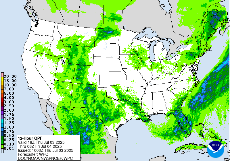
16Z Update: The threat for heavy rainfall across much of West TX
and New Mexico remains with ongoing flash flood threats extending
from the Permian Basin over into Southwest TX. The threat will grow
across areas of TX east of the Permian Basin with the Concho Valley
and adjacent Hill Country getting more into the mix as we move
later in the day and overnight hours. The SLGT risk was adjusted a
bit more to the east to account for trends in the heavier QPF
signals via CAMs. Coincidentally, the CAMs are now in agreement
with the heavy rain axis noted via ECMWF AIFS ML and other ML tools
allowing for a greater confidence in the threat. This was enough
for the small adjustment and general maintenance for the threat.
Look for pockets of 2-4" with locally up to 6" possible over any
area encompassed by the SLGT risk from Southeast NM over into West
TX.
New Mexico will see less in terms of maxima, but still looks like
conditions will improve with diurnal heating this afternoon
allowing for another round of convection to fire in-of the terrain
between the Sacramento's up into the southern portion of the Sangre
de Cristos. Greatest threat for flash flooding will occur within
the remnant burn scars and adjacent valley towns that are impacted
by heavy thunderstorms. This threat will begin to dissipate
overnight with decoupling processes, but any outflow generation
could maintain convection a little longer over Eastern NM before it
completely ceases. The SLGT risk was maintained over the area with
no changes from previous forecast.
Kleebauer
..Previous Discussion..
A mid-to-upper level shortwave moving into southern
California this morning will move into the Four Corners region by
this evening and then the central and southern Rockies overnight.
The large scale lift associated with the wave, along with ample
moisture remaining in place, are expected to produce widespread
showers and thunderstorms across Arizona and New Mexico. A Slight
Risk was maintained across the eastern New Mexico and West Texas
mountains into the High Plains, where additional storms are
expected to develop across the same areas that have received
several rounds of storms and periods of flash flooding over the
past several days. A Marginal Risk was maintained farther to the
north into the central Rockies, extending into parts of southern
Wyoming, where the overnight guidance continues to indicate the
potential for localized heavy amounts as the deeper moisture is
drawn northward ahead of the advancing shortwave.
While differing in the details, the models continue to show a
notable signal for more widespread heavy amounts developing further
east into parts of central Texas. Continued to extend the Slight
Risk from eastern New Mexico and West Texas out into parts of
Northwest Texas and the Hill Country. Persistent southerly flow
will support a widespread area of PWs AOA 2 inches (+3 std dev),
supporting the potential for heavy amounts. The Slight Risk was
drawn to include areas where the 00Z HREF showed high neighborhood
probabilities for amounts of over 2 inches, with notable
probabilities for amounts of 3 inches as well.
Pereira
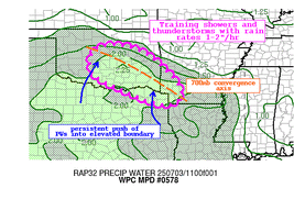
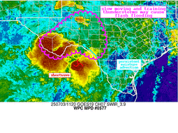
...Eastern Oklahoma to central Louisiana...
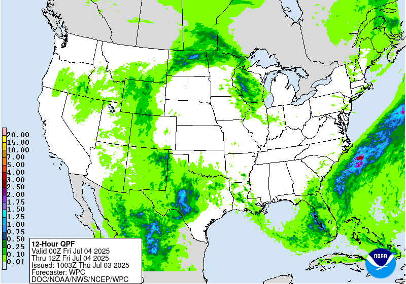
16Z Update: Multiple flash flood warnings were issued this AM for
the threat as a focused area of convergence within the boundary
referenced in previous discussion allowed for a pocket of
training/redevelopment over parts of Eastern OK. Rainfall rates
were noted ~3"/hr at times which coincides with the anomalous
moisture presence (12z KOUN sounding depicted 2.01" PWATs), so any
stronger convective cores will be capable of locally enhanced rates
and flash flood concerns. The boundary slopes southeastward into
Northern LA with the cu field bubbling over the area and other
cells pulsing up near the ArkLaTex. The threat will linger through
the afternoon with the activity waning after sunset with
traditional diurnal heat loss. Until this occurs, isolated flash
flood prospects will remain with the best threat likely over
Southeast OK through the ArkLaTex towards I-20 in Northern LA. The
MRGL risk was maintained with no deviation from previous forecast.
Kleebauer
..Previous Discussion..
A slow-moving returning boundary is expected to become the focus
for deeper moisture (PWs ~2 inches), which along with daytime
heating and modest mid-to-upper level forcing, is expected to
produce a swath of slow-moving storms later today, capable of
producing heavy rainfall rates and accumulations. The overnight
HREF shows a decent signal for some locally heavy amounts,
especially from central/southeastern Oklahoma through the ArkLaTex
into central Louisiana. Neighborhood probabilities for amounts
over 2 inches are above 50 percent across this region. Given the
relatively high FFGs covering much of this area, opted to introduce
just a Marginal Risk area at this time.
Pereira
...Southeast...
The previous SLGT risk was removed in this update as trends for
scattered to widespread coverage of heavy rainfall have all but
deteriorated on the latest guidance across FL. Latest ASCAT pass
across the Gulf signaled very little in the way of an organized
area of low pressure meaning the entire setup is being driven by
frontal convergence and mean troughing positioned across the
Northeastern Gulf. The best signal of convergence remains over
Southwest FL leading to some amounts exceeding 1-2" over places
like Ft. Myers down into Naples. The rates are still lacking
however, as the expected convergent pattern is just not sufficient
for those enhanced rates that were expected previously and
necessary for flash flood concerns in this part of the CONUS. There
are still inferences within the CAMs on pockets of heavier rainfall
materializing through the period, but the coverage is less than
optimal for a higher risk. 12z KTBW sounding came with a solid warm
cloud layer and PWATs running ~2.2" meaning the environment is
capable, but missing that ascent pattern necessary to access the
potential. Still, any convective cores will be capable of 2-3"/hr
rates with the best threat over any urbanized zones.
The threat for isolated flash flooding extends up the GA/SC coastal
areas where elevated PWATs and differential heating will likely
spark another round of slow-moving convection capable of locally
heavy rainfall and isolated flash flooding with 2-4" of rain
plausible in any stronger cell development. The MRGL risk was
maintained for these areas, along with the extension into the
Southeast FL metro.
Kleebauer
...North Dakota/Northwest Minnesota...
16Z Update: The setup for strong nocturnal thunderstorms to impact
ND into Northwest MN remains with a consistent signature of heavy
rain encroaching Northwest ND with cell propagation to the
northeast as we move through the period. This threat remains within
the lower threshold for the MRGL risk, however the anomalous
moisture presence allows for a bit of a better threat locally
compared to normal. HREF neighborhood probs are privy to at least
1" falling over the area north of Bismarck with upwards of 2" still
within reason. The signals were basically similar to last nights
update, so didn't feel a need to change course, so maintained
general continuity in the MRGL risk.
Kleebauer
..Previous Discussion..
Storms are expected to develop later this evening across North
Dakota along a slow-moving warm front and ahead of a subtle
shortwave moving into the High Plains. Southerly flow is expected
to support an uptick in PWs (~1.5 inches). While widespread heavy
amounts are not expected, models do show some potential for locally
heavy amounts, bolstered by a period of slow-movement followed by
training cells. A Marginal Risk was introduced for the area where
the HREF showed high neighborhood probabilities for amounts over an
inch. The HREF indicates the greater threat for heavier amounts
centers over northwestern North Dakota, where slow-moving storms at
the onset may produce locally heavy amounts. The HREF shows some
modest probabilities for amounts over 2 inches across this area.
Pereira
...Wisconsin...
16Z Update: The overall synoptic pattern and general convective
expectation has not changed since the previous forecast. The one
shift was the orientation of the heavier QPF a bit more to the
southwest when assessing the differences fields in the CAMs. The
HREF blended mean shifted approx 25-50 miles further west and
southwest from the 00z suite, so the adjustment was made to reflect
the change. Otherwise, the probability signals are actually more
robust for >2" with the 12z HREF neighborhood probs now upwards of
50-80% extending from Eau Claire down through the Milwaukee metro.
This is more than enough confidence to maintain the risk area in
place with only that minor adjustment necessary to reflect the
latest QPF alignment.
Kleebauer
..Previous Discussion..
A Marginal Risk was also added over portions of Wisconsin, where a
downstream portion of the previously noted front will become a
focus for deeper moisture and slow-moving storms tonight. The
signal for heavy amounts and potential flash flooding is a little
greater across this area. Amplifying southwesterly low level inflow
will support PWs climbing to ~1.5-1.75 inches, which along with a
weak shortwave moving across the top of an upper ridge, will
support storm development. Guidance indicates slow storm movement,
with some backbuilding, supporting the potential for locally heavy
amounts. The HREF shows neighborhood probabilities as high as 50
percent for amounts over 2 inches centered over northwestern
Wisconsin.
Pereira
Day 1 threat area:
www.wpc.ncep.noaa.gov/qpf/94epoints.txt
Excessive Rainfall Discussion
NWS Weather Prediction Center College Park MD
1155 AM EDT Thu Jul 3 2025
Day 2
Valid 12Z Fri Jul 04 2025 - 12Z Sat Jul 05 2025
...THERE IS A SLIGHT RISK OF EXCESSIVE RAINFALL ACROSS PORTIONS OF
EASTERN NORTH DAKOTA AND NORTHWESTERN MINNESOTA...
...Northern/Central Plains and Upper Midwest...
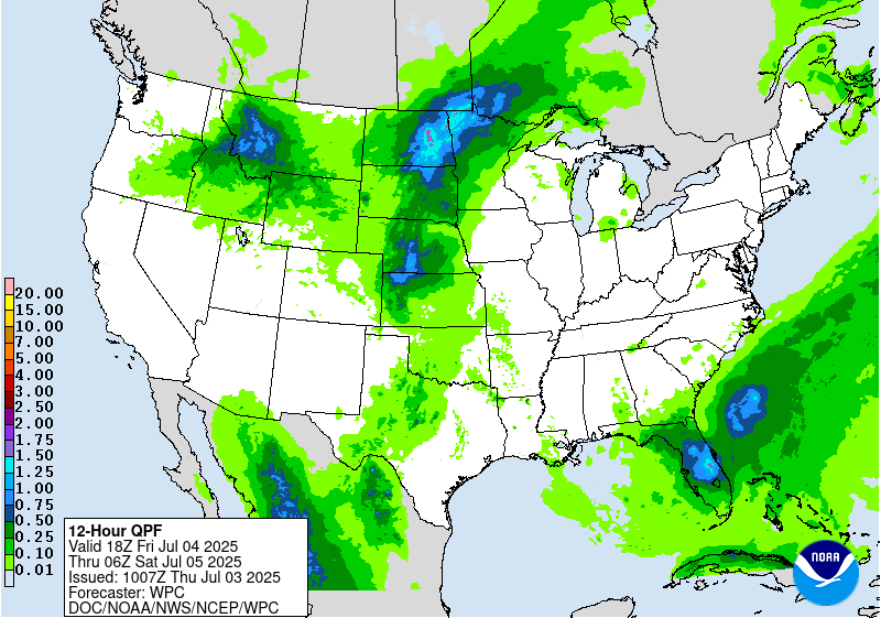
A much stronger signal for heavy amounts and possible flash
flooding is expected to unfold across parts of eastern North Dakota
and northwestern Minnesota late Friday into early Saturday.
Southerly winds ahead of a shortwave trough lifting northeast into
the Northern Plains will support PWs climbing to ~2 inches (+2 to
3 std dev). Storms are expected to develop by late afternoon and
train southwest to northeast ahead of a slowly advancing cold
front. With the HREF indicating that 12-hr amounts (ending 00Z Sat)
are likely to exceed 2 inches in some locations, a Slight Risk was
introduced across parts of eastern North Dakota and northwestern
Minnesota. A Marginal Risk was maintained farther to the south into
parts of the Central Plains where convection developing over the
High Plains during the afternoon is expected to advance more
steadily east, limiting the heavy rainfall/flooding threat.
...Southern Plains...
While the better forcing is expected to lift to the north, plenty
of moisture will remain (PWs ~2 inches), fueling the potential for
additional storms and heavy amounts. A Marginal Risk was introduced
across portions of Northwest Texas into Southwest Oklahoma -
centered where some the guidance shows at least locally heavy
amounts.
...Northern Rockies...
A Marginal Risk was maintained across parts of Idaho, western
Montana, and northwestern Wyoming, where widespread light to
moderate, with embedded locally heavy amounts are expected. A well-
defined shortwave trough along with fairly anomalous PWs (+1 to 2
std dev) are expected to support locally heavy amounts and an
isolated flash flooding threat.
...Florida...
The environment will remain favorable for widespread rain and at
least locally heavy amounts across much of the peninsula, with some
areas possibly seeing additional amounts over 3 inches. While an
upgrade to a Slight Risk may be forthcoming, model spread remains
fairly significant, and therefore maintained just a Marginal Risk
for now.
Pereira
Day 2 threat area:
www.wpc.ncep.noaa.gov/qpf/98epoints.txt


