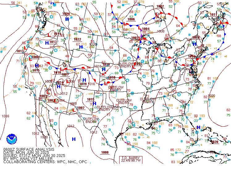
Excessive Rainfall Discussion
NWS Weather Prediction Center College Park MD
850 PM EDT Mon Jun 30 2025
Day 1
Valid 01Z Tue Jul 01 2025 - 12Z Tue Jul 01 2025
...THERE IS A SLIGHT RISK OF EXCESSIVE RAINFALL ACROSS PORTIONS OF
THE CENTRAL/SOUTHERN PLAINS AND THE NEW MEXICO AND WESTERN
TEXAS...
...01Z Update...
Biggest adjustment at 01Z was to shift the Slight Risk area
further south across the Southern Plains. Recent runs of the HRRR
and the 18Z HREF generally agree that convection will continue
along a southwest-northeast axis from the Permian Basin in western
Texas to the Ouachita Mountains in southeastern Oklahoma and
western Arkansas. Neighborhood probabilities from the 18Z HREF
indicate that localized amounts of 2-3 inches are likely along this
axis during the remainder of the evening and overnight. Further to
the north, the Marginal Risk was removed from the Central Plains.
Elsewhere, made mostly minor adjustments based on radar trends and
recent hi-res guidance.
Pereira
...16Z Update...
Main changes to the overnight forecast include the introduction of
a Slight Risk over portions of the eastern Ohio Valley, Central
Appalachians, and Upper Mid-Atlantic. 12Z sounding data across the
region highlights a very moist and unstable airmass (PWATS at or
above the daily max for PIT and IAD) in the vicinity of a slow
moving warm front. Showers and thunderstorms are forecast to expand
in coverage today with continued heating, which will be capable of
very efficient subhourly rainfall rates which could breach flash
flood guidance in spite of generally progressive storm motions.
Otherwise, the Slight Risk was trimmed in the Central/Southern
Plains in the wake of an overnight MCS which has sent a strong cold
pool southward. The main area of concern will focus along this
boundary later today, over portions of Central Oklahoma and Eastern
Arkansas into the Red River.
Asherman
Previous Discussion...
A Slight Risk was maintained across New Mexico and into western
Texas given the presence of a front dropping southward into the
Southern Plains and Southern Rockies...with moist easterly flow
into the complex terrain of the southern Rockies and provide
greater coverage of thunderstorms by the afternoon due to diurnal
heating, increasing lapse rates and instability. Precipitable water
values of 1 inch to 1.5 inches are forecast and will near the 90th
climatological percentile and support rainfall rates of 1-2 inches
per hour. Additionally, widespread coverage of thunderstorm
activity over parts of the Central and High Plains overnight was
accounted for by the introduction of a Slight Risk mainly from
Kansas into Oklahoma this morning before another round of
convection forms over the Southern High Plains along the associated
frontal boundary within an area of very weak mid- level flow later
today. Storms will likely be slow- moving across western Texas and
eastern New Mexico before becoming outflow dependent unless a
large enough cold pool can organize a larger thunderstorm complex.
Elsewhere...convection is expected to develop within a region of
decent CAPE and precipitable water values in excess of 2 standard
deviations above climatology. Except for some mid-level westerly
flow around the Great Lakes to provide some shear there...the flow
farther south should be fairly meager (but offset by steeper low-
level lapse rates). This sets up the potential for some local
rainfall rates in excess of 1 inch per hour that results in
excessive rainfall from the southern Plains east/northeastward into
the Ohio Valley and parts of the Mid- Atlantic region today and
tonight.
Some details are coming into focus, which includes the
likelihood of overnight convection lingering into the early-morning
hours across parts of the central Plains and Mid- Mississippi
Valley. Meanwhile, an upper trough lingering across the Southeast
will continue to foster an area of convergence on the
southern/southwestern periphery which could lead to locally heavy
rainfall along the eastern Gulf Coast and much of the northern
Florida Gulf Coast. There is some potential for extremely heavy
rainfall within this tropical airmass and precipitable water values
between 2.25 inches and 2.5 inches, but the signal from the
numerical guidance is that most rainfall to occur over the Gulf
waters at this time.
Farther north into the Ohio Valley, Appalachians and Northeast, a
weakening surface boundary will help focus some of the threat for
heavier rainfall with its placement remaining quite uncertain. The
synoptic setup with a stationary/warm front stretching across
southern PA and an approaching cold front from the west should help
foster greater coverage in showers/storms within a moist
environment, but storm motions within a mean column wind of 30kts
could limit the flooding threat even though this area remains
sensitive to intense rainfall.
Snell/Bann
Day 1 threat area:
www.wpc.ncep.noaa.gov/qpf/94epoints.txt
Excessive Rainfall Discussion
NWS Weather Prediction Center College Park MD
426 AM EDT Tue Jul 1 2025
Day 1
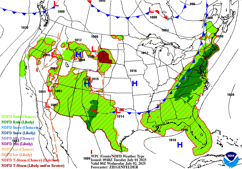
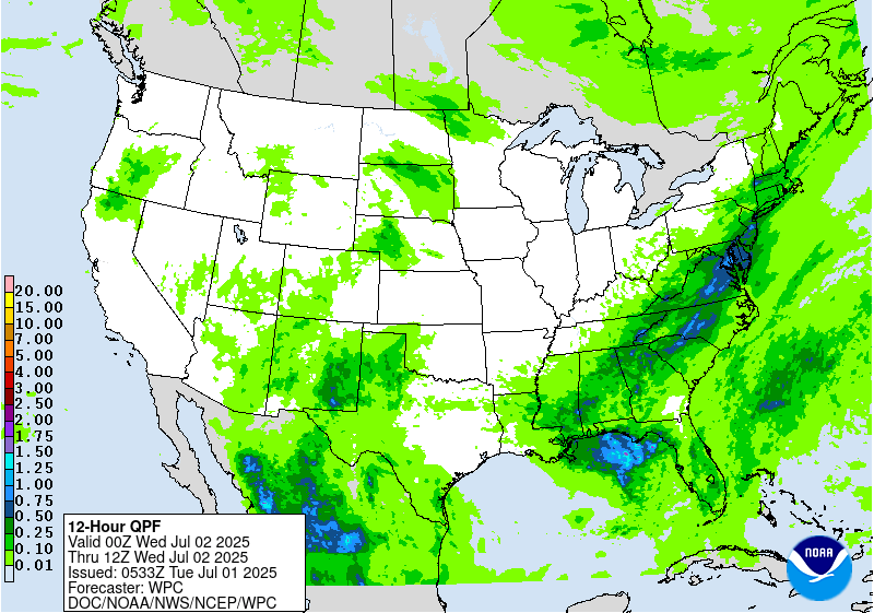
Valid 12Z Tue Jul 01 2025 - 12Z Wed Jul 02 2025
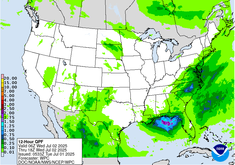
..THERE IS A MODERATE RISK OF EXCESSIVE RAINFALL OVER NORTHERN
PORTIONS OF THE MID-ATLANTIC REGION...
...Eastern Seaboard...
Per collaboration with WFOs CTP, PHI, and LWX, we have included a
Moderate Risk to the Day 1 ERO across parts of the northern Mid
Atlantic Region to include NoVa and the DC-Balt metro regions,
northern DE and into southeast PA.
Longwave upper trough over the Upper Great Lakes/Midwest early
this morning will pivot eastward Tue-Tue night, pushing east of the
Appalachians Wed morning. Embedded within the longwave trough is a
shortwave, currently along the IA/IL/MO tri- state area, which
will track across the OH Valley later this afternoon and across the
Mid Atlantic later this evening and overnight. This shortwave
should enhance the broad- scale across the Mid Atlantic region
(especially), while low-level frontogenesis also gets a boost south
of the 90-100kt upper jet streak in the lee of the large-scale
trough.
0-6km bulk shear values increasing to 25+ kts within the inherited
broad Slight Risk area (30-40+ knots over the northern Mid Atlantic
into the Northeast) will support the formation of
widespread/multi-cluster line segments ahead of the upper
trough/surface cold front during peak diurnal instability hours
this afternoon into the evening. MUCAPEs peak between 2000-3000
J/Kg, while TPWs remain around 2 standard deviations above normal
for early July (between 2.00-2.25" within the non-convective
environment across much of the Mid Atlantic into southern New
England). The concern over the Slight and especially Moderate Risk
areas will be with upwind propagation and cell training, as the
pre-frontal southwesterly low-level flow (20-25 kts at 850 mb
becomes nearly parallel and of similar magnitude as the mean
850-300 mb flow. 00Z HREF and RRFS probabilities of 24hr QPF
exceeding 3" climb above 60% within much of the Moderate Risk
area (highest with the RRFS), while probs exceeding 5" within the
24hr period reach 40-60% in spots per the RRFS (though 20-25% tops
per the HREF). Given the favorable thermodynamic profile (high
CAPE/PW environment) along with the broad-scale forcing, anticipate
areas of 2 to 3+ inch/hr rainfall rates this afternoon and evening.
The Moderate Risk area also encompasses areas recently hit by
heavier rainfall, evidenced by the lower FFGs (in some areas, 1 hr
FFGs 1.00" or less). This includes areas SE PA including the
Middletown/Lancaster/Lebanon/Redding areas that received 4-7" of
rain on Monday.
...West Texas into New Mexico...
Farther south/west along the stalled frontal boundary...convection
is expected to be develop within a region of decent CAPE and
precipitable water values in excess of 2 standard deviations above
climatology. This area will also benefit from weak upper level
vorticity/shear axis within the broad-scale ridge, with tropical
moisture feeding in per the low-mid layer southeasterly flow.
850-700 mb moisture transport is pretty solid across the outlook
areas, but especially within the Slight Risk region across parts of
West TX into southeast NM where the 850-700 mb moisture flux
standardized anomalies peak between 3-4 standard deviations above
normal per the 00Z SREF and GEFS. Given the relatively healthy
low-level flow compared to the overall weaker mean flow, areas of
heavy, possibly excessive rainfall are anticipated, especially
within the Slight Risk area, considering the uptick in upwind
propagation and thus chances for cell training.
...South Texas...
An influx of abnormally high TPW from the remnants of Tropical
Cyclone Barry (2.2 to 2.4", which is close to 3 standard
deviations above normal for early July) will combine with a
modestly unstable environment (MUCAPEs increasing to 1500-2500
J/Kg) in producing very heavy short-term rainfall rates later this
afternoon/evening and potentially later into the overnight period.
Both the HREF and RRFS ensembles show high probabilities (>50%) of
3+ inch rainfall, with 30-40% probs of exceeding 5 inches.
Therefore expect more than a localized risk of flash flooding
(i.e. Slight vs Marginal) across portions of South Texas from
Corpus Christi south through Brownsville and the RGV.
Hurley
Day 1 threat area:
www.wpc.ncep.noaa.gov/qpf/94epoints.txt
Excessive Rainfall Discussion
NWS Weather Prediction Center College Park MD
426 AM EDT Tue Jul 1 2025
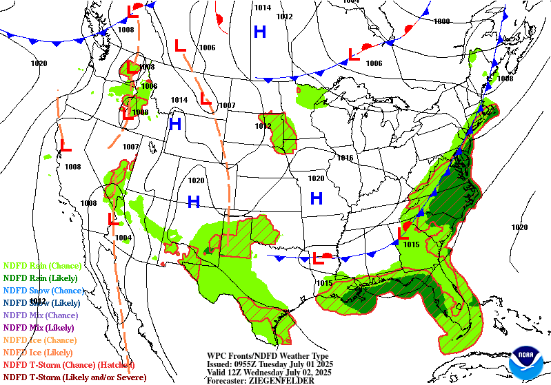
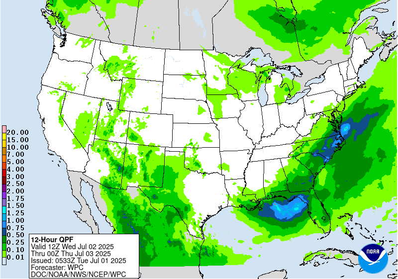
Day 2
Valid 12Z Wed Jul 02 2025 - 12Z Thu Jul 03 2025
...THERE IS A SLIGHT RISK OF EXCESSIVE RAINFALL ACROSS PORTIONS OF
SOUTHEAST VIRGINIA AND NORTHEAST NORTH CAROLINA...
...Lower Mid Atlantic and Southeast...
Pre-frontal convection will likely be ongoing across the Mid
Atlantic and Southeastern Seaboard Wednesday morning, with
additional line segments upstream as well prior to the passage of
the surface front and upper trough axis later in the day. Along the
axis of 2.25"+ TPWs, by early afternoon (17-18Z), both the HREF
and RRFS ensembles show an uptick in >2"/hr rainfall rates across
southeast VA and northeast NC, particularly the RRFS (25-50%).
Available high-res CAM guidance (NAM Nest, FV3, and RRFS) all show
pockets of 3-5+ inch totals within the Slight Risk area. Elsewhere
within the Marginal Risk area stretching through much of the
Southeast, anticipate the flash flood threat to be more
isolated/localized as 0-6 km bulk shear values remain aob 20kt
(implying more pulse/less organized convection).
...West Texas into parts of the Southwest...
Continued moist, southeasterly low-level flow (850-700 moisture
transport/flux standardized anomalies +3 to +4 again from West TX
into NM) will set the stage for numerous showers and storms again,
especially during peak heating hours Wed afternoon and evening.
Strong low-level inflow is in some areas double the mean 850-300 mb
flow, thus resulting in Corfidi vectors opposing the low-level
wind. This will likely lead to cell training, especially where the
southeasterly low-level flow leads to more upslope enhancement.
Right now, the guidance (including the CAMs that go out through
Day 2) show considerable spread with the heavier QPF. Therefore for
now will maintain a more isolated (Marginal) flash flood risk, as
later shifts will evaluate once the period (Wed-Wed night) gets
within the remainder of the high-res CAM windows.
Hurley
Day 2 threat area:
www.wpc.ncep.noaa.gov/qpf/98epoints.txt
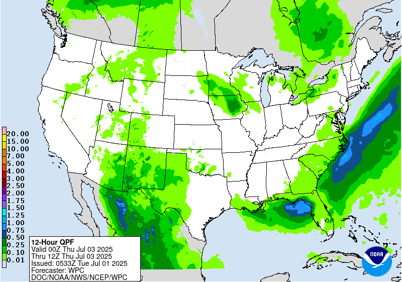
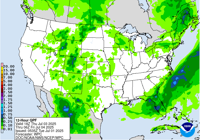
Excessive Rainfall Discussion
NWS Weather Prediction Center College Park MD
426 AM EDT Tue Jul 1 2025
Day 3
Valid 12Z Thu Jul 03 2025 - 12Z Fri Jul 04 2025
...THERE IS A SLIGHT RISK OF EXCESSIVE RAINFALL ACROSS WESTERN
PORTIONS OF THE FLORIDA PENINSULA...
...Southern Georgia through northern and central Florida...
Subtle changes were made to the Slight and Marginal Risk areas
inherited from yesterday's Day 4 ERO. Southern periphery of the
longwave upper trough crosses the area Thu-Thu night, with the
guidance showing embedded shortwaves (possibly convectively-
enhanced) reaching South FL toward the end of the period (12Z Fri).
Ahead of the nearly stationary surface front, onshore west to
southwest low-level inflow from the eastern Gulf will likely lead
to a more focused area of low-level moisture transport/flux
convergence over much of the west coast of FL, especially north of
Ft. Myers to include the Tampa-St. Pete area, where 0-6km bulk
shear values do approach 25 kts (allowing for more
organized/widespread convective clusters). The RRFS is most
particularly robust with the QPF within the Slight Risk area (areas
of 3-6+ inches), which considering the thermodynamic
environment/deep subtropical moisture (TPW values 2.25 to 2.50"),
is certainly plausible. Especially considering the onshore low-
level inflow will likely exceed (perhaps double) the mean 850-300
mb wind), enhancing the potential for cell training. Even with a
more limited (tall/skinny) CAPE profile, sub-hourly rainfall rates
of 2.5-3.0+ inches within this environment will be possible,
especially within the Slight Risk area.
Elsewhere, few changes were made to the inherited Marginal Risk
area across the Northern Plains-Upper MS Valley and again across
West TX into the Southwest (including southern-central Rockies).
Guidance at this point shows considerable spread to support
anything more than a Marginal.
Hurley
Day 3 threat area:
www.wpc.ncep.noaa.gov/qpf/99epoints.txt
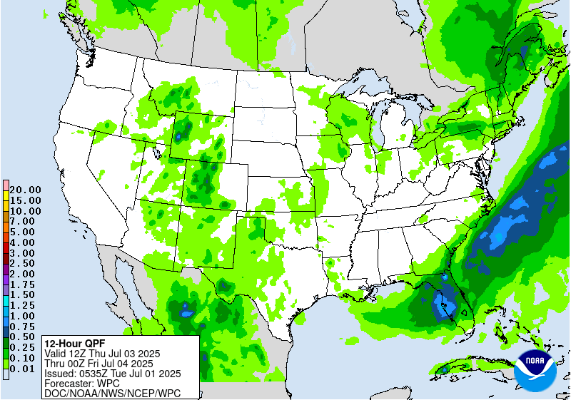
Extended Forecast Discussion
NWS Weather Prediction Center College Park MD
237 AM EDT Tue Jul 1 2025
Thunderstorms with deep moisture and instability will support heavy
convective downpours along/south of a lingering Florida front into
the weekend. WPC Excessive Rainfall Outlook (ERO) Marginal Risk
areas are in place for Day 4/Friday and Day 5/Saturday in a region
with precursor heavy rains and anomalous Gulf tropical moisture.
Latest guidance has backed off on explicit QPF despite a favorable
pattern feeding off the eastern Gulf as being looks at by the NHC.
Monsoonal moisture with some connection to current eastern Pacific
Hurricane Flossie and some Gulf moisture from recent Barry may
boost rain potential that may linger into Friday over the Big
Bend and vicinity where an ERO Marginal Risk area is depicted.
Periodic afternoon and nocturnal strong to severe storms/MCS
activity offer heavy rain/runoff potential to focus over the north-
central Plains and Upper Midwest late week into Saturday as upper
trough/impulse energies work over the northern periphery of the
main central U.S. upper ridge as moisture/instability pools near
wavy passing and draping fronts. WPC ERO Marginal Risk areas have
been introduced for Day 4/Friday and Day 5/Saturday. Weekend to
early next week activity with upper system/frontal progressions
then works over the central Midwest/Great Lakes and the Northeast
while continued activity refires back to the north-central states
near the trailing and wavy frontal zone with uncertain local focus.
Schichtel


