Excessive Rainfall Discussion
NWS Weather Prediction Center College Park MD
851 PM EDT Wed Jul 2 2025
Day 1
Valid 01Z Thu Jul 03 2025 - 12Z Thu Jul 03 2025
...THERE IS A SLIGHT RISK OF EXCESSIVE RAINFALL ACROSS PORTIONS OF
THE WESTERN FLORIDA PENINSULA AND THE SOUTHWESTERN U.S...
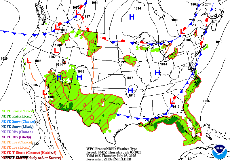
...01Z Update...
The Slight Risk over portions of southeast VA and eastern NC has
been dropped now that the heaviest rainfall threat has concluded.
The northern extent of the Marginal Risk across the Southeast was
scaled back as well, with the strongest thunderstorms activity now
concentrated from southern NC on south to the Gulf Coast and the FL
Peninsula. The Slight Risk along the western shores of the FL
Peninsula remains in place given 18Z HREF probabilistic guidance
still shows moderate-to-high chances (50-70%) for additional
rainfall totals >3" between now and 12Z Thursday AM. The higher end
of this probabilistic range is also located over the Tampa/St.
Petersburg metro area. In the Southwest, the Marginal and Slight
Risk areas were tweaked based on newest 18Z HREF guidance and radar
trends, but otherwise these threat areas remain in place through
tonight.
Mullinax
---Previous Discussion---
...Lower Mid Atlantic and Southeast...
16Z Update: Main adjustments for the region were to remove places
where the front has progressed through with a dry air advection
regime taking shape, ending the threat for convection. The rest of
the forecast remains on track as pre-frontal areas will remain
solidly within an environment capable of locally heavy rain of
convective origin. 12z HREF blended mean QPF footprint continues to
signal the heaviest precip focused across the Hampton Roads area of
the VA Tidewater down through Eastern NC where PWATs ~2" and MUCAPE
signals of 2000-2500 J/kg are adequate for elevated hourly rates
capable of flash flooding in more urbanized zones. With consistency
in the forecast, there was no reason to deviate from previous SLGT
risk issuance, so continuity was maintained.
Kleebauer
..Previous Discussion..
Longwave upper trough and embedded shortwave energy will push
slowly eastward today, finally pushing off the Mid Atlantic coast
this evening. At the surface, the associated cold front will too
exhibit gradual eastward progression, likely not pushing off the
coast until sometime Thursday. The very favorable deep-layer
thermodynamic environment ahead of the upper trough/surface front
will be characterized by PWATs between 2.2-2.4" (~2 standard
deviations above normal) along with MUCAPEs of 1000-2000 J/Kg.
Based on the 00Z guidance and trends, only minor adjustments were
made to the Slight Risk area across eastern NC and southeast VA.
00Z HREF neighborhood probs for >3" were still running between
70-90% over the Slight Risk area, with >5" probs peaking between
40-50%.
Scattered heavy convection will also be forecast away from the
above area with the main threat likely more urbanized flash flood
concerns within any heavier cells as the environment is ripe for
locally heavy rainfall from the Central Gulf coast to points north
and northeast.
Hurley
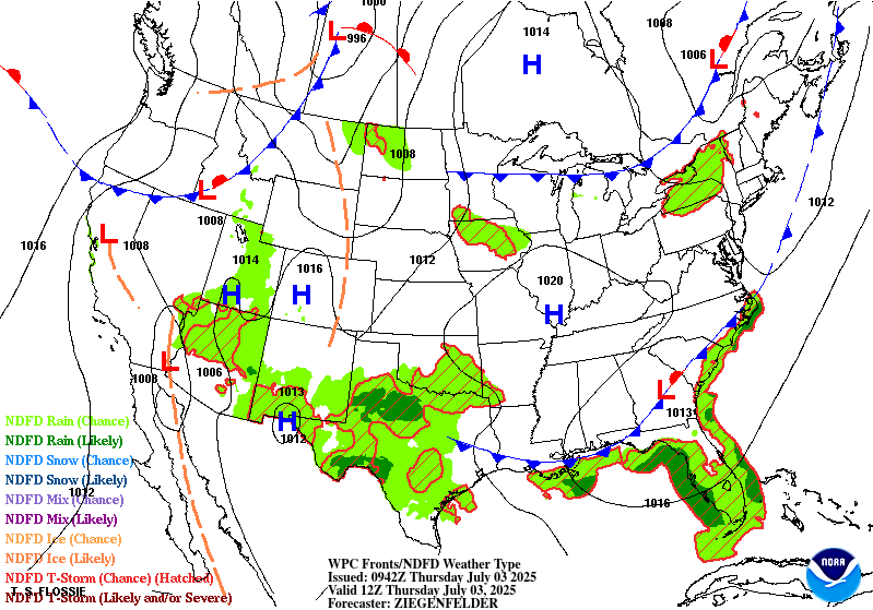
...Southwest...
16Z Update: The SLGT was nudged a bit further south to include more
of the Davis Mtns. across Southwest TX where 12z CAMs were more
bullish on coverage in the terrain. This was reflected within the
neighborhood prob fields on the latest HREF output embedding a
modest signal over that specific area. A small extension to the
east was also made to include more of the Pecos river valley out near
Roswell, NM. Otherwise, the forecast remains on track with the
best signal for flash flooding across the terrain of Southern NM,
Southeast AZ, and much of the Mogollon Rim.
Kleebauer
..Previous Discussion..
Modest eastward expansion across southeast NM and West TX was made
to the Slight Risk area inherited from yesterday's Day 2 ERO. This
based on the latest guidance trends; not just with the bump in
deterministic QPF (especially ensemble of CAMs), but also with the
rise in QPF exceedance probabilities per both latest HREF and RRFS.
Synoptic progression across the Southwestern CONUS coupled with a
deep, moist advection pattern further inland from the southeast
will lead to widespread convective development across West TX,
extending westward through the terrain of NM and AZ. A stagnant
upper trough/ULL slowly migrate across far southern CA later today
and Wed night. This will push the region of favorable upper level
diffluence/large scale ascent to much of the Desert Southwest east
of the Colorado river basin. Presence of monsoonal moisture will be
amplified moving into Wednesday as the amplified flow from the
approaching trough and ridge positioning over the Four Corners will
create the textbook funneling affect of deeper moisture poleward
through West TX to points north and northwest.
PWAT anomalies between 2-3 standard deviations above normal are
again noted across West TX into southern and central NM-AZ, which
with MUCAPEs between 1000-2000+ J/Kg, will create a generally
buoyant environment over the aforementioned areas. The expectation
is for scattered heavy convective cores capable of hourly rates
approaching 1"/hr with generally slow cell motions leading to some
training concerns across the terrain. 00Z HREF 24hr ARI exceedance
probabilities for exceeding 10yr intervals peak between 40-70%
across southern MN, with even spotty 10-30% probs of exceeding
the 100yr ARI, a testament to the expected magnitude of precip
falling during the period. Locally 2-3+" of rainfall within the
area is plenty to cause significant flash flood issues in any one
area across the Sacramento's through the terrain west and
northwest.
Hurley/Kleebauer
...Western Florida Coast...
16Z Update: There was not any change to the previous SLGT risk
situated across the Western FL coast with the primary area of
concern remaining the western portions of Pasco and Hillsborough
counties, along with all of Pinellas county where the Tampa metro
is centered. The threat remains conditional on the evolution on an
area of low pressure centered over the Eastern Gulf at the tail end
of a cold front migrating slowly into the region. There's
discrepancy on exactly how close the low is to the coastal area by
this evening with some guidance inferring a further offshore SLP
that would likely inhibit a stronger convective pattern moving
inland. Other guidance is centered closer to the coast with a more
defined coastal convergence regime along the western FL Peninsula
which would generate a swath of heavier rainfall embedded in a
fairly tropical airmass (2.2-2.4" PWATs) as noted via forecast
soundings and GOES- East derived products. 12z HREF probs were
lower compared to the overnight forecast output, but still
respectable for both the >3" (50-80%) and >5" (20-40%). The issue
becomes the general positioning is right at the coast with a sharp
delineation as you move further inland. Considering the setup and
potential, the SLGT risk was maintained to account for the threat,
even if conditional. If there is activity, it will likely be heavy
rain with rates between 2-4"/hr considering the deep warm cloud
layer presence, as well as a focused convergence regime on the
eastern flank of any low that develops.
Kleebauer
Day 1 threat area:
www.wpc.ncep.noaa.gov/qpf/94epoints.txt
Excessive Rainfall Discussion
NWS Weather Prediction Center College Park MD
851 PM EDT Wed Jul 2 2025
Day 2
Valid 12Z Thu Jul 03 2025 - 12Z Fri Jul 04 2025
...THERE IS A SLIGHT RISK OF EXCESSIVE RAINFALL ACROSS WESTERN
PORTIONS OF THE FLORIDA PENINSULA, WEST TEXAS, AND NEW MEXICO...
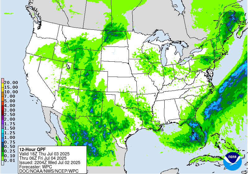
...Florida...
20Z Update: The pattern will remain active for the FL Peninsula
with much of the guidance in agreement on a threat of heavy
rainfall across the Western coast of the state. HREF neighborhood
probs from 12z paint a very wet picture for the immediate Tampa/St.
Pete metro down towards Ft. Myers with >5" probs running between
40-70% with some low end (20-30%) probs for even greater than 8"
for the time frame. Tropical airmass in place will allow for very
efficient warm rain processes to be the driver for the threat with
forecast soundings off the latest CAMs signaling wet bulb zero
heights approaching 15000ft MSL. These are the environments capable
of significant rainfall rates and the ability to accumulate rapidly
when they occur. With the threat of 3-6" on top of what comes to
fruition on D1, flash flooding could become closer to reality for
many areas along the stretch extending from Clearwater down into
Ft. Myers and the I-75/275 corridor. The SLGT risk remains with a
potential for a higher end SLGT focused over the area, pending how
D1 evolves.
Kleebauer
..Previous Discussion..
Subtle changes were made to the Slight and Marginal Risk areas
inherited from yesterday's Day 3 ERO. Southern periphery of the
longwave upper trough crosses the area Thu-Thu night, with the
guidance showing embedded shortwaves (possibly convectively-
enhanced) reaching South FL toward the end of the period (Thursday
night). Ahead of the nearly stationary surface front, onshore west
to southwest low-level inflow from the eastern Gulf will likely
lead to a more focused area of low-level moisture transport/flux
convergence over much of the west coast of FL, especially north of
Ft. Myers to include the Tampa-St. Pete area, where 0-6km bulk
shear values do approach 25 kts (allowing for more
organized/widespread convective clusters). The RRFS is most
particularly robust with the QPF within the Slight Risk area (areas
of 3-6+ inches), which considering the thermodynamic
environment/deep subtropical moisture (TPW values 2.25 to 2.50"),
is certainly plausible. Especially considering the onshore low-
level inflow will likely exceed (perhaps double) the mean 850-300
mb wind), enhancing the potential for cell training. Even with a
more limited (tall/skinny) CAPE profile, sub-hourly rainfall rates
again of of 2.5-3.0+ inches within this environment will be
possible underneath the strongest cells, especially within the
Slight Risk area.
Hurley
...Southern Plains to Southwest...
Continued deep moist advective pattern will lead to scattered or
even widespread thunderstorm activity over much of West TX up
through the Central Rockies as the upstream synoptic evolution of
the ejecting trough will create a pretty robust large scale ascent
signature across much of the CONUS west of the 100W marker. The
setup for Thursday has come into better agreement within the 12z
NWP suite leading to not only greater consensus in the where, but
also an upgrade in the magnitude, or "how much" rainfall could
occur with the setup. The driver of the pattern is the combination
of broad ridging to the east and the approaching trough from the
west creating a defined meridional push of warm moist air poleward
allowing PWATs to surge between +2 to +3 deviations above normal.
These types of anomalies are coincident with deeper moist columns
and higher wet bulb zero heights contributing to more efficient
rainfall processes and higher rates. NASA SPoRT outlines a large
area of above average soil moisture with the top layer exhibiting
closer to the 90th percentile in moisture which would likely cause
a higher threat for runoff if rates are sufficient.
The greatest area of concern lies within the Eastern Permian Basin
up through the Concho Valley and adjacent areas within Hill
Country. This area encompasses a vast amount of low-water crossings
and hillier terrain capable of runoff and funneling water towards
areas more prone to flooding. 12z HREF EAS probs for at least 1" is
pretty high (40-60%) near the San Angelo area up through the
Southeast Permian Basin. Even some low-end 2" probs within the EAS
are situated in that zone, a testament to consistency in the signal
and the prospects for more widespread 2-4" totals during the
threat. Rates between 1-2"/hr will be on the common side for the
area with some intra-hour rates possibly exceeding 3"/hr at times
during the strongest convective cores. The question was always the
specifics of, "where?" for the setup. Now that models are in
agreement on the spatial aspects of the convective threat, but in
tandem with an elevated magnitude spurred an addition of a higher
risk with a SLGT risk now in place across a good portion of West
TX.
As for areas of NM, the moisture anomalies are still present, but
not as significant compared to areas to the southwest. That said,
the area around the Upper Trans Pecos, Sacramento Mtns., and NM
Caprock have been impacted by periods of flash flooding from
convection for several days the past 2 weeks. This setup only acts
to add to the incessant nature of the pattern and contribute to the
potential. The poleward expansion of the elevated moisture
signatures extend as far north as the Central Rockies with the
highest moisture signals south of I-40. Considering the better
probs for even >2" of rainfall potential in the state, the SLGT
risk was expanded from TX through much of NM with the focus lying
within the 3 areas referenced above.
Kleebauer
Day 2 threat area:
www.wpc.ncep.noaa.gov/qpf/98epoints.txt
Excessive Rainfall Discussion
NWS Weather Prediction Center College Park MD
851 PM EDT Wed Jul 2 2025
Day 3
Valid 12Z Fri Jul 04 2025 - 12Z Sat Jul 05 2025
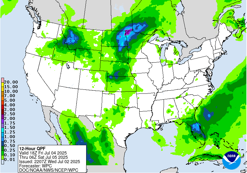
...THERE ARE MARGINAL RISKS OF EXCESSIVE RAINFALL ACROSS PARTS OF
THE NORTHERN ROCKIES, NORTHERN AND CENTRAL PLAINS, UPPER
MISSISSIPPI VALLEY, AND THE FLORIDA PENINSULA...
20Z Update: The previous forecasts remain on track with only some
minor differences in the orientation and magnitude of expected
heavy rainfall for the 3 areas of interest. Will note the prospects
for a targeted SLGT risk are certainly plausible in-of portions of
the Northern Plains and Upper Midwest with the area of greatest
concern likely to lie within the zone encompassing Northeast SD,
Southeast ND, and Western MN where local FFG's are lowest due to
previous convective episodes that compromised soils enough to
promote targeted lower flash flood indices. With some of the
ensembles and ML output signaling perhaps an adjustment in the
heaviest rainfall further south as we move closer to the time
frame, maintain MRGL risk posture, but will assess the trends
carefully to see if an upgrade would be necessary in any area
outlined.
Kleebauer
..Previous Discussions..
...Florida Peninsula...
Lingering upper level shortwave energy along with a surface
reflection (surface low along west coast and associated frontal
boundaries) will again maintain a favorable environment for more
organized (widespread) convection, particularly during peak
diurnal heating. Not surprising given the lead time (day 3
forecast), spread with the current model QPFs is fairly high. As a
result, have maintained the Marginal Risk area inherited from
yesterday's Day 4 ERO, as the favorable thermodynamic environment
will support at least localized instances of flash flooding per the
isolated 24hr maxima of 4-7+ inches per the 00Z Regional GEM and
RRFS.
...Idaho into Montana and Northwest Wyoming...
Have hoisted a fairly broad Marginal Risk area across much of ID
and MT along with northwest WY based on the converging guidance
trends (QPF especially). Models show the longwave upper trough and
embedded shortwave energy becoming more negatively tilted as the
trough pivots across the Northwestern CONUS. Robust QG forcing is
noted as a result, with the deep-layer lift coinciding with a
favorable thermodynamic environment (PWATs 1-2 standard deviations
above normal and MUCAPEs ~500-1000 J/Kg would favor areas of
locally heavy rainfall, up to 3-4" per the CMC and 1.5-3" per the
ECMWF, GFS, and NAM. Given the terrain considerations and flashy
runoff and streamflow response within this region, have for now
hoisted a Marginal Risk area in anticipation of an isolated flash
flood threat.
...Eastern Portions of the Missouri Valley into the Upper
Midwest...
Expanded the Marginal Risk area from yesterday's Day 4 ERO to
include parts of eastern NE and northern KS. Deep-layer QG forcing
becomes more favorable by late Fri as the upper trough axis pushes
east. Meanwhile, SSW to SW LLJ will increase to 30-40 kts at 850 mb
Fri night, aligning parallel to and approaching the same magnitude
of the mean 850-300 mb wind. This results in a diminishment of the
Corfidi Vectors by Fri night, eventually becoming northerly and
opposing the low-level inflow. Given the degree of upwind
propagation expected, cell mergers and training will become more
likely by Fri night ahead of the approaching surface boundary.
However, the big uncertainty will be the degree of elevated deep-
layer destabilization, as at least for now much of the global
guidance is not overly bullish (MUCAPEs generally <1000 J/Kg north
of KS-southern NE). Given this along with the considerable spread
in model QPFs, for now have maintained a Marginal Risk ERO.
Hurley
Day 3 threat area:
www.wpc.ncep.noaa.gov/qpf/99epoints.txt
Extended Forecast Discussion
NWS Weather Prediction Center College Park MD
256 PM EDT Wed Jul 2 2025
Tropical moisture and instability will support heavy convective
downpours along/south of a lingering front across Florida through
the upcoming holiday weekend. WPC Excessive Rainfall Outlook (ERO)
Marginal Risk areas are shown for Day 4/Saturday and Day 5/Sunday
for west-central Florida as preceded by heavy rainfall.
Additionally, a Marginal Risk has been added for portions of the
South Carolina Low Country and into the greater Savannah metro area
for Day 4 given the increased moisture and rainfall potential
associated with the low pressure area that NHC is monitoring.
Periodic strong to severe storms/MCSs will offer periodic heavy
rain/runoff threats to focus from the north-central U.S. to the
Midwest this weekend as upper trough/impulse energies work on the
northern periphery of the main central U.S. upper ridge where
moisture/instability tends to be lifted near a wavy draping front.
WPC ERO Marginal Risk areas are depicted for Day 4/Saturday and
downstream for Day 5/Sunday. Into early-mid next week, showers and
embedded thunderstorms will focus near the slow moving front into
the Northeast/Mid-Atlantic, but also refire back across the north-
central states where ejecting upper-level waves will interact with
moisture and instability pooling frontal zones.
Meanwhile, a broadening upper ridge will spread a hazardous heat
and humidity threat from the Midwest this holiday weekend to the
Mid-Atlantic/Northeast into next week as a hot summer airmass
lingers broadly over the South and builds up across the West.
Schichtel


