Excessive Rainfall Discussion
NWS Weather Prediction Center College Park MD
852 PM EDT Sat Jul 5 2025
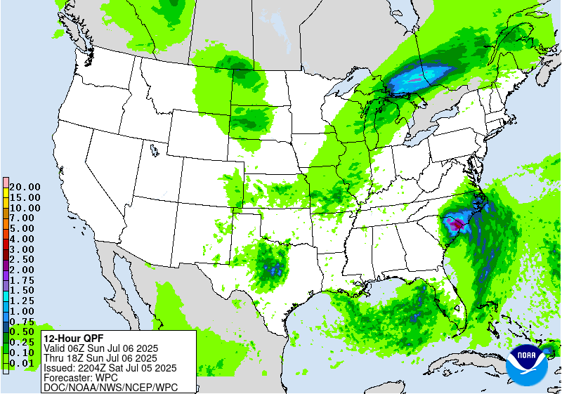
Day 1
Valid 01Z Sun Jul 06 2025 - 12Z Sun Jul 06 2025
...THERE IS A MODERATE RISK OF EXCESSIVE RAINFALL FOR A PORTION OF
CENTRAL TEXAS...
...Central Texas...
A new Moderate Risk area is out for a portion of central Texas.
The remains of Barry aloft and resultant "new" 850 hPa cyclone are
parting ways in a sheared environment, with the 850 hPa low moving
west while the mid-level trough moves east. Normally the night
after this happens is the last night/subsequent morning of heavy
rain potential. Effective bulk shear due to the opposing low-level
and upper-level flow is sufficient for organized convection and
cells being stuck in place. There's an instability gradient near
29.5N latitude, seen on SPC mesoanalyses, that's creeping north and
likely to be the better focus for heavy rainfall this period as
low-level inflow intercepts it -- used this as the southern bound
of the risk areas. The retrograding upper low is also a possible
spot for such...used its track as the northern bound of the risk
area. Some retrograding convection is possible on its west side as
outflow boundaries try to instigate new convection on that side of
the 850 hPa circulation/trough. Precipitable water values remain
near and above 2.25". ML CAPE south of the instability gradient is
2000+ J/kg. Convective environments with this much moisture in
northeast shear since 2016 (August 2016 convective low in Louisiana
and Imelda in 2019) have favored the wetter mesoscale guidance, so
leaned a bit on the high- resolution NAM, HRRR, and RRFS. Hourly
rain amounts to 4", with local amounts to 8", appear the best bet.
This on its own is problematic, but the heavy rains could also fall
on already saturated ground. Coordination with the TX forecast
offices -- SJT/San Angelo, EWX/New Braunfels, and FWD/Fort Worth --
as well as the National Water Center led to the new Moderate Risk
area. As a side note, the remains of Barry are the 20th tropical
cyclone or remnant since 1913 to produce 15"+ across interior
portions of Texas.
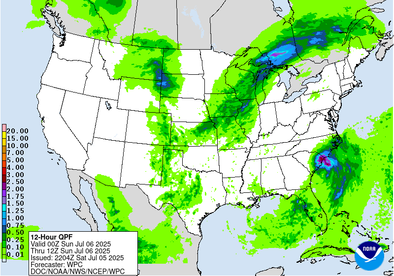
...Carolinas/T.S. Chantal...
Much of the high resolution guidance for Chantal keeps the focus of
heavy rainfall into the early morning hours Sunday near the NC/SC
border. The guidance has had a westward bias thus far, and radar
trends show that what passes as a CDO/Central Dense Overcast keeps
moving north more towards NC. Both the HREF/RRFS insist on a
northwest turn with an occluded look overnight, which would be
something and not befit a tropical cyclone that's supposed to be in
a less sheared environment. Tightened up the western gradient of
the risk areas as a precaution -- the SC portion of the risk areas
remains the most uncertain.
...Midwest...
Trimmed the area per radar reflectivity trends and HREF output.
Activity should forward propagate and fade overnight.
...Northern High Plains...
A well-defined shortwave moving into the northern High Plains is
leading to widely scattered thunderstorms. Forecast PWs are
expected of 1 to 1.25 inches (1 to 1.5 std dev above normal) are
high enough to imply saturation in the High Plains, implying
rainfall efficiency. While a widespread heavy rainfall event is
not expected, heavy rainfall rates and some potential for
redeveloping storms may produce locally heavy amounts (greater than
an inch) and isolated runoff concerns.
...Southeast Arizona...
See Mesoscale Precipitation Discussion #598 for more details.
...Western Florida...
Pared back the Marginal Risk area to western FL per radar
reflectivity trends and 18z HREF output. Convection should fade
and/or move westward into the Gulf.
Roth
Day 1 threat area:
www.wpc.ncep.noaa.gov/qpf/94epoints.txt
Excessive Rainfall Discussion
NWS Weather Prediction Center College Park MD
852 PM EDT Sat Jul 5 2025
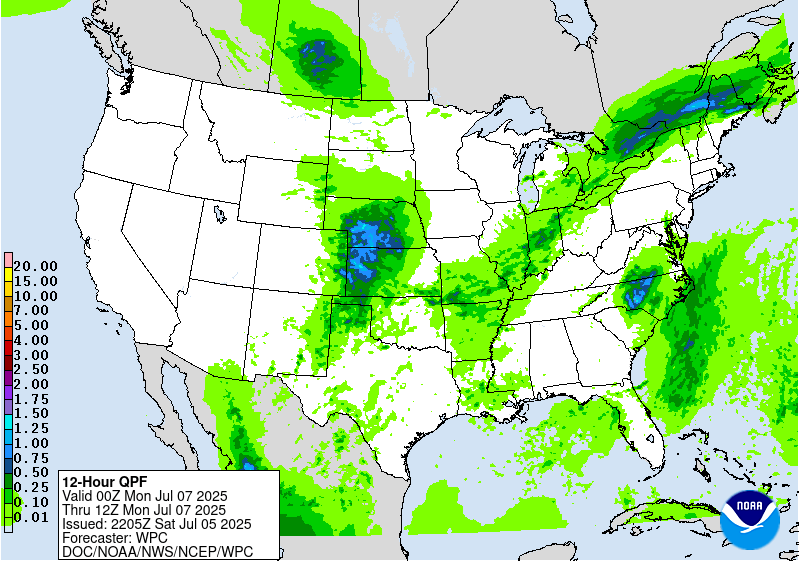
Day 2
Valid 12Z Sun Jul 06 2025 - 12Z Mon Jul 07 2025
...THERE IS A SLIGHT RISK OF EXCESSIVE RAINFALL FOR PORTIONS OF
CENTRAL TEXAS AS WELL AS FOR PORTIONS OF THE CAROLINAS...
...2030Z Update...
...Central Texas...
In coordination with SJT/San Angelo, TX and FWD/Fort Worth, TX
forecast offices, a Slight Risk upgrade was introduced with this
update for portions of central Texas. While moisture amounts and
advection will both be waning by Sunday, especially as compared
with previous days, there will certainly still be enough moisture
and forcing to allow for a renewed round of slow-moving showers and
thunderstorms to affect this area. The biggest contributing factor
to the upgrade is the ongoing flooding and its associated impacts.
Thus, even lesser amounts of rain, as forecast on Sunday, will
have outsized impacts given the vulnerabilities in that area. The
storms should taper off by sunset across central Texas, ushering in
a prolonged period of much drier weather.
...Carolinas/TS Chantal...
With the guidance better handling TS Chantal and its track through
the Carolinas, and a bit stronger storm forecast to make landfall
in South Carolina tonight, by Sunday the storm will be rapidly
weakening. However, its associated rainfall and abundant moisture
will persist well inland from the landfall point. Most of the
guidance is in very good agreement on where the swath of heaviest
rainfall will occur on Sunday, namely from north-central South
Carolina through central North Carolina. For now...the consensus
keeps the rainfall shield just east of Charlotte, but may impact
Greensboro, and perhaps Raleigh and Winston-Salem. Forecast
rainfall has increased markedly, with the swath of rainfall now
featuring amounts exceeding 3 inches in 24 hours (of course local
rainfall amounts will be higher). Despite antecedent dry soil
conditions, the potential for very heavy rainfall with Chantal's
remnants are very likely overcome the initially dry soils in that
area, resulting in flash flooding. However, the dry antecedent
conditions should at least delay any flooding, and of course take a
little off the top of any flooding's severity. Thus, have
introduced a Slight Risk for north-central South Carolina and
portions of central North Carolina, with an area from Greensboro
south into northern South Carolina in a higher-end Slight Risk.
Any slowing of the storm or a better signal for heavy rainfall over
a bigger urban center would require a targeted Moderate Risk
upgrade with future updates.
...Central Gulf Coast...
Widely scattered showers and thunderstorms across southern
Louisiana will have ample Gulf moisture to feed upon Sunday
afternoon. With the potential for any of those storms moving over a
sensitive urban area such as New Orleans or Baton Rouge, a Marginal
Risk was introduced with this update.
Wegman
Day 2 threat area:
www.wpc.ncep.noaa.gov/qpf/98epoints.txt
Excessive Rainfall Discussion
NWS Weather Prediction Center College Park MD
852 PM EDT Sat Jul 5 2025
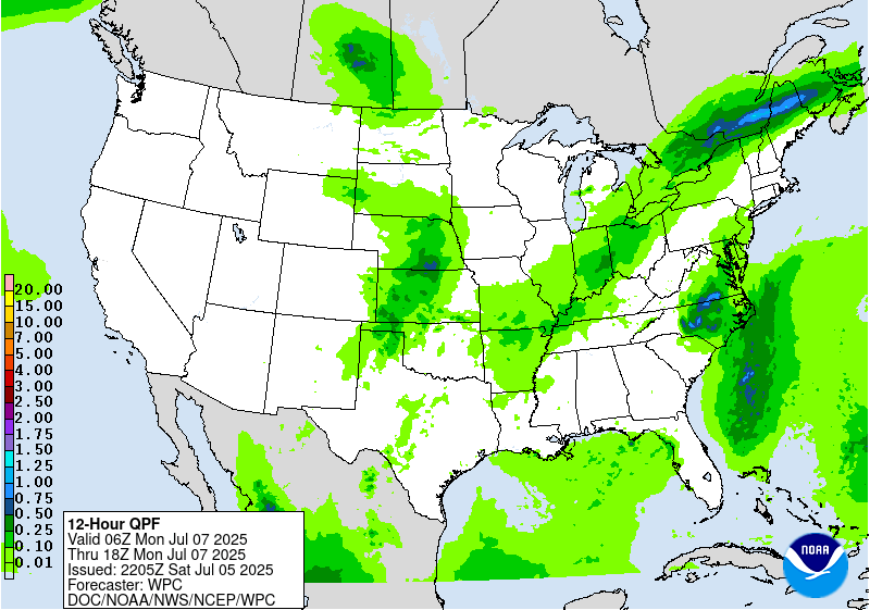
Day 3
Valid 12Z Mon Jul 07 2025 - 12Z Tue Jul 08 2025
...THERE IS A MARGINAL RISK OF EXCESSIVE RAINFALL FROM THE UPPER
MIDWEST TO THE SOUTHWEST, THE NORTHEAST TO THE OZARK REGION,
PORTIONS OF CENTRAL TEXAS, AND EASTERN NORTH CAROLINA TO
THE DELMARVA...
...2030Z Update...
...Eastern North Carolina and Southeastern Virginia...
The threat for heavy rainfall will continue to decrease, however
some additional heavy amounts are possible as Tropical Storm
Chantal moves over eastern North Carolina and southeast Virginia.
The inherited Marginal Risk was expanded north across much of the
Delmarva and the DC and Baltimore metros with this update for the
potential for widely scattered storms capable of very heavy rain.
While the heavy rain threat will be greater towards the Delmarva,
given the sensitivity of the DC and Baltimore metros to heavy rain,
opted to include them for that limited heavy rain potential.
...Northeast to the Ozark Region...
The previously noted cold front will push across the Northeast
while lingering back across the Ohio into the mid Mississippi
Valley. Overnight models indicate a greater threat for heavy
amounts will focus along with some right-entrance region upper jet
forcing and greater moisture anomalies across northern New England.
However, sufficient moisture is expected to remain in place ahead
of the boundary to support at least localized heavy amounts and an
isolated flooding threat further southeast along and ahead of the
boundary.
...Northern Plains and Upper Midwest...
Models show a well-defined shortwave moving across the region this
period. With plenty of differences in the details, models indicate
some potential for organized heavy rains developing ahead of this
wave as it interacts with an influx of deeper moisture.
...Central Plains to the Southern High Plains/Rockies...
Similar to the previous day, the models are presenting a notable
signal for showers and storms, supported by moist low level inflow,
to develop over High Plains, with some potential for locally heavy
amounts to occur as they move east. Besides minor model
differences, the only big changes was to carve out the Nebraska
Sand Hills from the Marginal Risk with this update.
Meanwhile, the coverage of storms and potential flooding concerns
is expected to expand across New Mexico as the monsoon pattern
builds, with moisture increasing across the region.
Pereira/Wegman
Day 3 threat area:
www.wpc.ncep.noaa.gov/qpf/99epoints.txt
Extended Forecast Discussion
NWS Weather Prediction Center College Park MD
248 PM EDT Sat Jul 5 2025
Showers and thunderstorms are expected to be focused in proximity
to progressive cold fronts, stalled boundaries and round the upper
high in the Southern Rockies. The wavy front into the eastern U.S.
may be a focus for heavier rain and thunderstorms. This includes
areas from the Corn Belt into the Midwest and Ohio Valley,
Appalachians, Mid-Atlantic, and Northeast. There are Marginal Risks
in place (level 1 of 4) for the Southwest, Central Plains/Midwest
to the Upper Mississippi Valley/Upper Great Lakes region and
portions of the Northeast for Day 4, and for the Mid-Mississippi
Valley/Midwest and portions of the Mid-Atlantic for Day 5 for an
axis of heavier rainfall possible south of a frontal boundary.
Heights across the Northeast and Mid-Atlantic regions will
gradually lower as troughing moves in. With the higher heights
shifting southward the heat will increase as well as begin to build
to the west as the upper high strengthens over the Southwest. Many
locations will have daily maximums climbing well into the 100s at
lower elevations which will greatly limit rain except for perhaps
far southeastern AZ into NM early in the week. Experimental
HeatRisk values may rise to Major or Extreme levels (3 out of 4 or
4 out of 4) from the California deserts into southern Nevada, Utah,
and Arizona.
Campbell/Fracasso


