Excessive Rainfall Discussion
NWS Weather Prediction Center College Park MD
156 AM EDT Thu Jul 10 2025
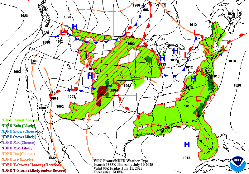
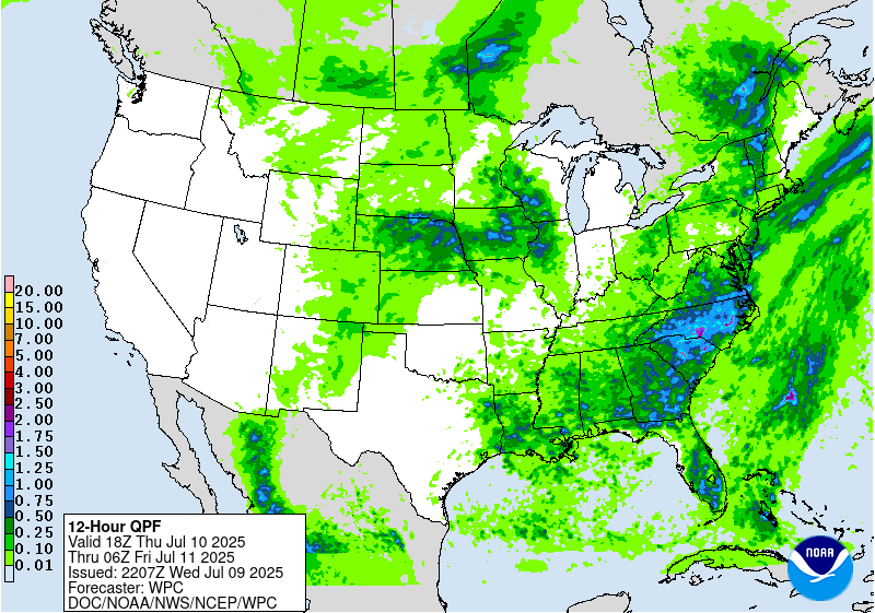
Day 1
Valid 0553Z Thu Jul 10 2025 - 12Z Fri Jul 11 2025
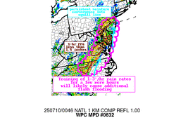
...THERE IS A SLIGHT RISK OF EXCESSIVE RAINFALL FOR PORTIONS OF
SOUTHERN NEW ENGLAND...
Special update based on radar trends and new 00z CAM guidance to
introduce a SLGT risk for portions of southern New England. See
upcoming MPD #633 for more detailed information.
Elsewhere, maintained MRGL risk areas for where some lingering
rainfall is still ongoing across portions of the Mid-Atlantic
(though convection continues to rapidly wane). The MRGL in place
for portions of the Central/Northern Plains was shifted east a bit
based on observational trends.
Churchill
Day 1 threat area:
www.wpc.ncep.noaa.gov/qpf/94epoints.txt
Excessive Rainfall Discussion
NWS Weather Prediction Center College Park MD
156 AM EDT Thu Jul 10 2025
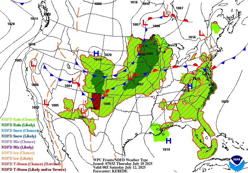
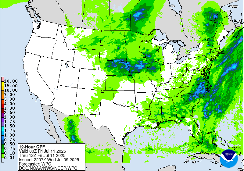
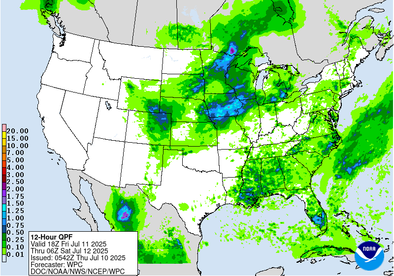
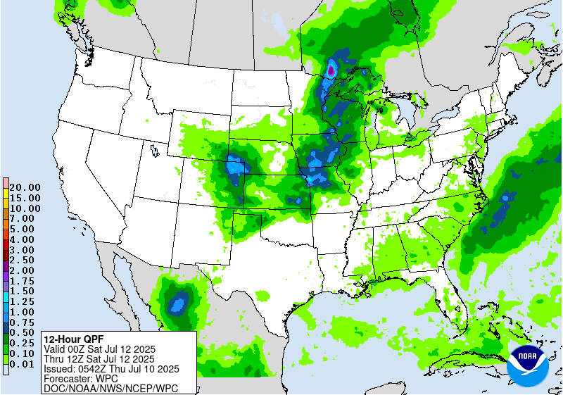
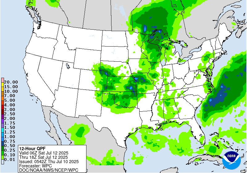
Day 2
Valid 12Z Fri Jul 11 2025 - 12Z Sat Jul 12 2025
...THERE IS A SLIGHT RISK OF EXCESSIVE RAINFALL FOR PORTIONS OF THE
MID ATLANTIC AND SOUTHEAST...
...Mid Atlantic and Southeast...
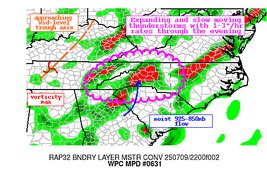
20Z Update: Conditionally unstable airmass will remain situated
across the Eastern Seaboard with a general instability maxima and
deep moist layer situated over the Southern Mid Atlantic through
SC/GA. A lee trough over the Piedmont of VA down through SC will
align with a formidable theta_E axis outlining an area of focus for
diurnally driven convection as we break into Thursday afternoon.
Forcing will be weak in the grand scheme, so the loss of sufficient
kinematics will mute the threat compared to Wednesday, but a
fairly buoyant environment and strong diurnal heat flux will remedy
the lack of large scale forcing and initiate a scattered to
widespread convective regime mostly driven via thermodynamic
processes and focused convergence within the lee trough center. 12z
HREF blended mean QPF depicted a smattering of maxima with 2-4"
signals extending over Eastern GA up through the Carolina Piedmont
into VA. Northern periphery of the best convective threat aligns
with the Potomac Basin as drier above 600mb advects through the
Central Mid Atlantic curbing some of the greater potential as you
move into MD/PA, so the prospects of heavier rainfall will lie
south of the shifting environment. Maintain general continuity from
previous SLGT issuance, but extended the SLGT further south and
west to account for the favorable convective regime through the
period with stronger convective cores still capable of local
2-3"/hr rates causing concern within any compromised areas from
prior periods, and urbanized settings where run off capabilities
are highest.
Kleebauer
...Northern and Central Plains into the Upper Midwest...
20Z Update: The synoptic evolution over the Plains and Midwest is
still very much advertised for late-Thursday afternoon through
early Friday morning with a likely organized convective window
transpiring downstream of an approaching shortwave trough.
Strongest signal within the CAMs remains parked over IA with some
expansion westward into Eastern NE where the organized multi-cell
pattern will likely occur after cells initiate upstream across the
Sandhills and High Plains of NE. 12z HREF EAS is actually
relatively robust across Central IA where CAMs are in excellent
agreement on a regional maxima positioned near Des Moines overnight
Thursday into Friday. This is coincident with the progression of
nocturnal complex expected to materialize over NE with the mean
flow likely to orient the complex on a west to east trajectory
near/over I-80. LLJ introduction will aid in supplemental low-level
moisture advection maintaining suitable MCS maintenance for a time
before the system collapses as it exits IA into IL. Pending forward
propagation speed, it's plausible the complex can reach North-
Central IL by the time the period ends with some remnant heavy rain
cores moving into the I-39 corridor. This potential evolution has
merit within the 12z EC AIFS Ensemble with a low-end prob for
heavier QPF output to the west of the Chicago metro. In this case,
the previous SLGT risk was modified a bit more to the east to cover
for higher probabilities for >2 and >3" outputs via the HREF and to
account for the AIFS ensemble depiction which has a pretty solid
track record with handling convectively driven disturbances inside
48hrs.
Kleebauer
..Previous Discussion..
By Thursday the persistent ridge aloft over the Southwest U.S.
begins to break down, as an upper-low off the northern CA coast
opens up into a shortwave trough on Wednesday and ejects eastward
ahead of a digging longwave trough over western Canada. These two
features look to interact over the Northern and Central Plains, but
there are still substantial differences between models in how
these features evolve and interact. PWs of 1.5"+ are expected
(near the 90th percentile for the region) with ample instability
and dynamics for organized convection and subsequent high rainfall
rates (as this shortwave trough looks much more potent relative to
the expected shortwave on Day 1). Maintained an inherited Slight
risk area that was adjusted based on the new consensus guidance.
Churchill
Day 2 threat area:
www.wpc.ncep.noaa.gov/qpf/98epoints.txt
Excessive Rainfall Discussion
NWS Weather Prediction Center College Park MD
156 AM EDT Thu Jul 10 2025
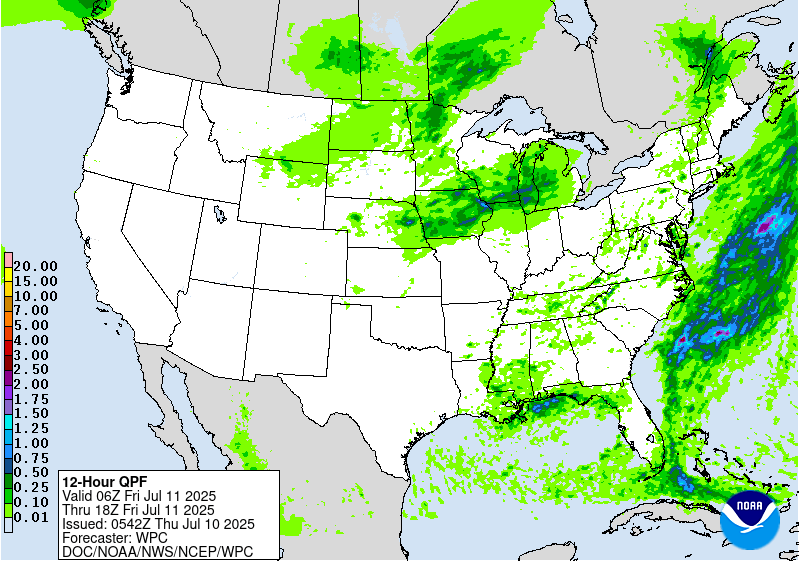
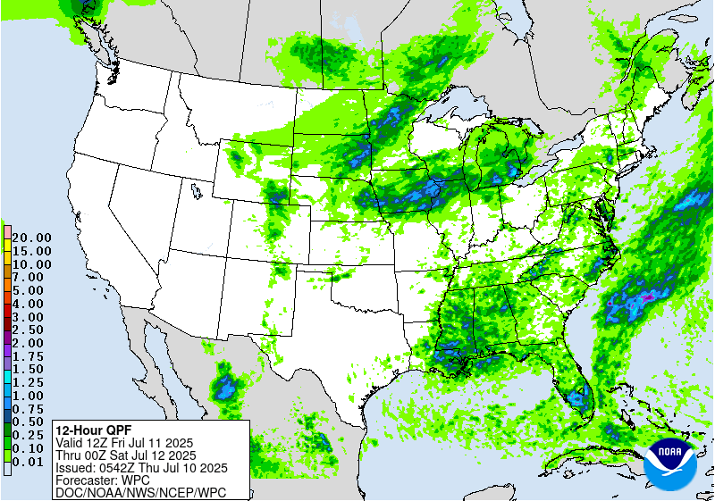
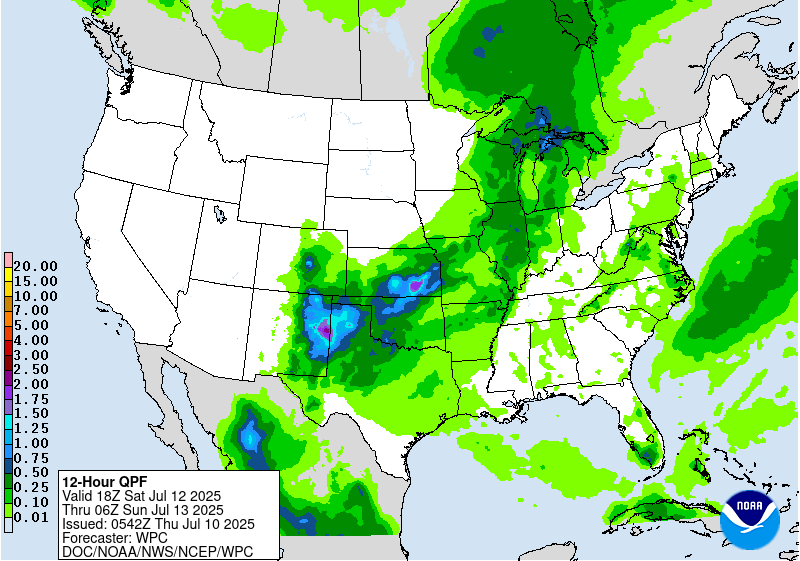
Day 3
Valid 12Z Sat Jul 12 2025 - 12Z Sun Jul 13 2025
...THERE IS A SLIGHT RISK OF EXCESSIVE RAINFALL OVER PORTIONS OF
THE MIDWEST...
...Midwest into Mid-Mississippi Valley...
20Z Update: Secondary vorticity maxima migrating through a
relatively low amplitude portion of the mid-level regime will eject
eastward in a similar path to the previous disturbance, only this
time encountering a more suitable environment with a deeper IVT
pulse being advected poleward ahead of the mean trough. A stronger
shortwave will also be digging south of out Canada allowing for a
better meridional push of deep layer moisture into the Upper
Midwest while also creating a more defined RER jet dynamic thanks
to a strengthening 250mb jet streak ~110kts positioned over the
Dakotas to Northern MN. Models have come into agreement on a west-
southwest to east-northeast oriented heavy convection regime with
some multi-cellular organization likely given increasing shear and
large scale forcing instigating the pattern. Totals between 2-4"
are being forecast already within the global deterministic with the
ensemble mean QPF firmly between 1-2" over a large area
encompassing Eastern NE, much of IA, Southern MN, and Western WI.
This correlates well with the forecast alignment of the stronger
IVT advection being pumped into the area due to the increasing
meridional state of the synoptic field. This setup has a pretty
robust indication via ML output as well, so the confidence has
grown enough to warrant a broad SLGT as the threat could be in
overlap of some hard hit areas the period prior. This will be an
evolving threat and the positioning of the risk could change in the
coming days, but wanted to align with consensus on initial
thinking.
Further south, a bit more complexity in the potential with less
agreement within the deterministic suite on potential heavy
convection across portions of MO/IL to the south of the pattern
evolving over the Midwest. Instability will be suitable overall,
but could be missing some elements to help push this threat to a
higher risk. Still, a fairly robust PWAT forecast and solid
thermodynamic structure should provide some modest risk for
isolated flash flooding, at a minimum. Maintained continuity of a
MRGL in the area to account for the potential and will be monitored
for targeted upgrade opportunities if the signal increases in
magnitude and/or coverage.
Kleebauer
...Mid-Atlantic and Southeast...
20Z Update: No changes necessary to the previous forecast as the
pattern remains favorable for isolated heavy rainfall across much
of the Southeast into the Southern Mid Atlantic.
Kleebauer
..Previous Discussion..
As mid-level troughing becomes more established in the Northern
Plains into Day 3, ridging builds in response downstream and may
finally begin to suppress convection more significantly across the
northern Mid-Atlantic into the Northeast. While there are no clear
signs of significant convective organization at this juncture into
the Southeast and southern Mid-Atlantic, convective initiation with
scattered convection and locally high rainfall rates appears likely
(where ridging will be insufficient to fully suppress convection).
Churchill
...Rockies into the Central and Southern High Plains...
20Z Update: A slightly better signal is being depicted across the
Front Range on Friday with a chance for a stronger convective
complex to initiate off the WY/CO Front Range and migrate east-
southeast along as the 850-300mb mean flow orients out of the
west-northwest in-lieu of a digging trough dropping out of Canada
to the north. A cold front trailing a surface low maturation over
the Central Plains would only entice a focal area for not only
heavy rainfall, but increasing prospects for back-building and
training behind any complex. The environment for locally enhanced
rainfall from any diurnally driven convection within a narrow lee
trough across the Southern High Plains and anticipated cold front
approach from the north will also lead to isolated flash flood
prospects from Southwest KS down into the Upper Trans Pecos. This
threat is on the lower end of the MRGL threshold, but still has
credence when assessing the overall environment. The MRGL will
remain in place from previous forecast, but will be keeping an eye
on perhaps a targeted upgrade in-of the migrating complex
anticipated off the Front Range.
Kleebauer
..Previous Discussion..
As the Southwest ridge continues to break down for a second day,
the global guidance signal for more substantial convective
initiation within the terrain of the Rockies increases into Friday
(and particularly so farther north into the northern/central
Rockies of WY/CO). Localized 1-2" totals (as indicated by both
downscaled deterministic GFS/ECMWF solutions and ensemble 1"
exceedance probabilities) in the sensitive terrain may lead to
localized flash flooding concerns, and more substantial convective
organization in association with shortwaves/vorticity maxima
rounding the ridge and coming off the terrain may allow for more
organized convection into the evening/overnight in the Central and
Southern High Plains.
Churchill
Day 3 threat area:
www.wpc.ncep.noaa.gov/qpf/99epoints.txt
Extended Forecast Discussion
NWS Weather Prediction Center College Park MD
313 PM EDT Wed Jul 9 2025
A frontal system will push through the Midwest and trail across
the south-central Plains this weekend. Convection is likely ahead
of it where moisture and instability pool, and a large Day
4/Saturday Marginal Risk covers the potential for isolated flash
flooding in these areas. Relatively greater chances of flash
flooding are centered over Oklahoma or so, where an MCS is likely
to develop and train. Model guidance shows spread in where this
will set up. AI models have been favoring a southeastern position
closer to the Red River, and the 00/12Z ECMWF and the 12Z CMC are
trending in this southerly direction. Thus started to lean toward
this by broadening the Slight southward across the Red River
compared to the previous issuance. Much the same meteorological
setup is likely on Sunday, but with the front progressing eastward
across the Great Lakes. Thus show a Marginal Risk along and ahead
of the front on Sunday as well. Compared to the previous Day 5 ERO,
expanded the Marginal north into the Lower Great Lakes region
where the best forcing and still sufficient instability is, and
expanded west through the southern Rockies/High Plains with a
particular nod toward the sensitive burn scars there. Will continue
to hold off on any Slight Risks without any consensus in heavy
amounts and their position.
Farther south, above normal moisture is forecast to move into
Florida along with ample instability underneath the broad
subtropical ridge. A Marginal Risk remains in place for Day
5/Sunday for much of the peninsula for the low end flash flooding
threat. This looks to last into at least Monday, and convection may
increase in the southeastern states by Tuesday as a front moves
closer.
The next front coming into the north-central U.S. Monday-Tuesday
is likely to cause additional rain there Monday and especially into
Tuesday. Details in placement and amounts will vary depending on
the eventual evolution of the trough, so stay tuned for further
details.
Temperature-wise, the western U.S. can expect above normal
temperatures as upper ridging mostly sets up to the west of rounds
of troughing. This puts highs well into the 100s and 110s for the
Desert Southwest, and nearing/exceeding 100F farther north in
interior/lower elevation areas of the Great Basin. Temperatures
could be a few degrees cooler than average especially for highs for
the south-central U.S. this weekend as clouds and rain hold
temperatures down. The Southeast should be near normal to a few
degrees above, for typical summer heat and humidity. Temperatures
will generally be 5-10 degrees above normal in the Great Lakes to
Northeast. Into next week, depending on the evolution of the north-
central U.S. trough, temperatures may cool notably, with highs
perhaps only in the 70s through the north-central Plains for
Tuesday/Wednesday.
Tate


