Excessive Rainfall Discussion
NWS Weather Prediction Center College Park MD
1153 AM EDT Fri Jul 11 2025
Day 1
Valid 16Z Fri Jul 11 2025 - 12Z Sat Jul 12 2025
...THERE IS A SLIGHT RISK OF EXCESSIVE RAINFALL FOR PORTIONS OF THE
MID AND UPPER MISSISSIPPI VALLEY AS WELL AS FOR PORTIONS OF THE
CENTRAL HIGH PLAINS...
...Mid and Upper Mississippi Valley...
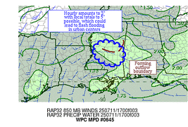
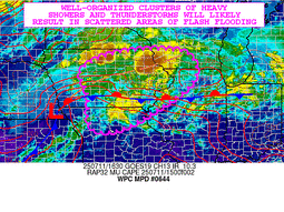
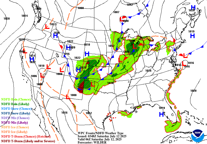
16Z Update: The overall evolution and anticipated flash flood
concerns were slightly changed from the previous forecast, but the
threat remains over much of the area outlined. There was some
shift in the heavier precip focus a bit further north into WI, a
lot to do with how the shortwave progression and a developing MCV
are handled as CAMs indicate a east-northeast motion out of IA this
evening leading to the primary vorticity exiting into southern WI
overnight. The proximity of the disturbance will play a critical
role in the strongest low-level convergence regime and flanking
convective development, so this is something that will need to be
monitored closely for near term adjustments. From a dynamical
standpoint, the setup makes sense as the regional amplification
expected can lead to disturbances gaining a bit more latitude,
thus shifting the focus a bit further north, at least on the
northern periphery of a shortwave. 12z HREF blended mean output
still puts the relative QPF maxima in-of the Quad Cities area of IA
with a strong consensus for heavy rain throughout much of WFO
Davenport's CWA as everything materializes. This is evident with
assessment of the latest HREF EAS prob fields for >2" signaling a
widespread 30-60% signal within the CWA bounds, so the threat for
elevated flash flooding prospects and a higher-end SLGT is
certainly in play over Eastern IA.
Neighborhood probabilities for >2 and >3" have increased across
southern WI, especially southwest WI along the US151 corridor from
the Mississippi river up near Madison. This adjustment is also
reflected into the Milwaukee metro, but not as pronounced compared
to area further south and west. As we move north, there's a growing
consensus for any meso-low or defined SLP center to occlude by the
end of the forecast cycle and shift focus for heavy precip along
the northern and northwest flank of the circulation. 12z CAMs were
pretty much in agreement on that type of evolution which can be a
sneaky way of getting a secondary maxima to crop up in the short
term. HREF prob fields are all over the threat as well with modest
(20-35%) probs for exceeding 3 and 6hr FFG intervals. Compared to
<10% for either probability in the 00z forecast, this is a pretty
stark shift in the potential, one that has enough merit to warrant
an expansion of the SLGT further north through WI where
probabilities are highest.
Further south into MO, trailing cold front will shift eastward with
the progression likely forming a broad area of deep layer flow
becoming increasingly uni-directional in-of the MO/KS border down
into northeastern OK. This was very well depicted in the RAP
925-700mb wind vectors with forecasted convection likely initiating
and situating southwest to northeast with cell motion along a
similar path. This could manufacture another area of locally heavy
rainfall capable of flash flooding. The greatest threat is likely
over southeast KS, southwest MO into northeast OK where the mean
wind is aligned best over an area where convection is expected
overnight. HREF neighborhood probs for >3" is now upwards of
25-45% with >2" probs over 60% across the aforementioned area. This
was enough to expand the previous SLGT risk further south to
account for the threat.
Kleebauer
..Previous Discussion..
A robust southwesterly low level jet streaming from the Plains into
the Mid-Mississippi Valley will provide a steady supply of Gulf
moisture into the region today. Meanwhile, a potent upper level
shortwave trough will approach this area from the west. The
combination of abundant moisture, instability, and forcing from the
shortwave will lead to numerous thunderstorms from northern
Missouri through eastern Iowa, northern Illinois, and far southern
Wisconsin, including the Chicagoland area. An MCS moving across
Iowa this morning will weaken in the morning daylight hours in
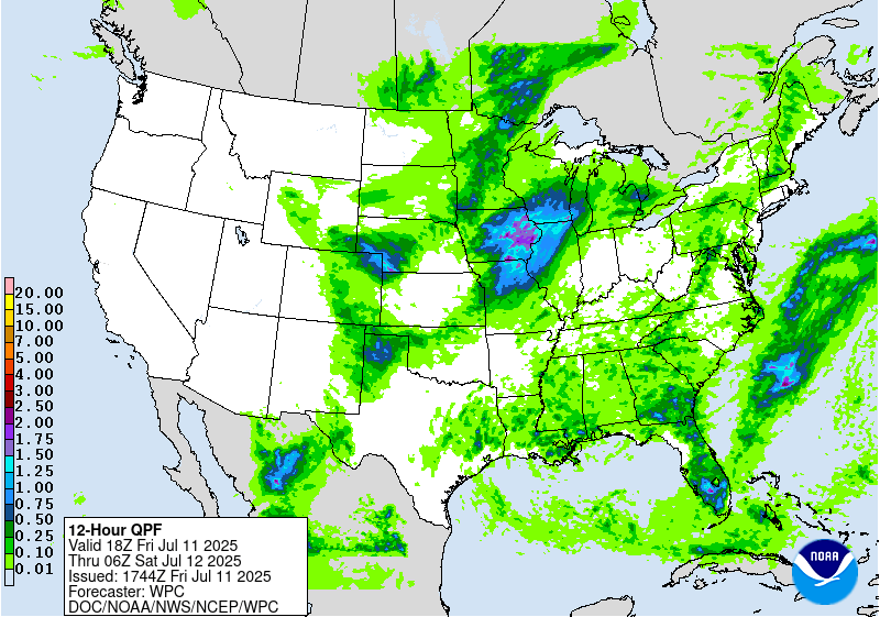
typical behavior for MCSs. Rainfall totals yesterday in the area
ranged from 1-4 inches, with the highest amounts across northern
Illinois west of Chicago. This rainfall has likely contributed to
saturating the soils in this area. Thus, the additional rainfall
forecast for this area should result in widely scattered flash
flooding. A higher-end Slight remains in place with only minor
changes from inherited, namely to trim up the southern end of the
Slight along the Kansas/Missouri border.
Showers and thunderstorms are likely to develop over central Iowa
as early as early this afternoon. As additional storms from in
northern Missouri, and track northeastward along the Mississippi
River, the potential for training storms will increase as the line
of showers and storms moves into northern Illinois. Backbuilding
may continue supporting additional thunderstorm formation as far
south as St. Louis this evening. This will likely allow the
potential for training storms to persist, increasing the flash
flooding threat.
Wegman
...Central High Plains...
16Z Update: Signal for locally heavy rainfall in-of an advancing
MCS out of the Front Range still remains elevated between the
triangle of Cheyenne/North Platte/Goodland with the best
probabilities for >2" positioning in the middle of these 3
population centers. Rates between 1-2"/hr for multiple hrs will
have the capability of localized flash flooding in the vicinity of
this region within the High Plains. 3 and 6hr FFG exceedance
probabilities remain steadily between 40-60% over the expected path
of the complex, enough to maintain general continuity of the
previous SLGT risk with only minor adjustments on the edges.
Kleebauer
..Previous Discussion..
As a strong shortwave trough digs southeastward across the northern
Plains, divergence at the base of the trough will increase the
lift, supporting storms across northeastern Colorado this afternoon
and evening. Meanwhile, typical leeside troughing will support
thunderstorm formation immediately downwind of the Front Range,
generally between Cheyenne and Denver along I-25. Storms may
initially form as early as 22Z/4pm MDT. As the storms move east off
the Front Range, they will encounter increasingly favorable lift
from the shortwave, as well as some Gulf moisture tracking
northward up the Plains. This will allow the storms to organize and
grow upscale in coverage and heavy rain potential. It is in this
region near the Colorado/Nebraska/Kansas tripoint which will have
the greatest threat for flash flooding with some limited potential
for training. With very low FFGs, especially across northeastern
Colorado (1-1.5 in/hr), a Slight Risk upgrade was hoisted with this
update. Some of the guidance suggests the storms will persist well
into tonight generally across far northwestern Kansas, so the
Slight Risk area includes that area as well.
Wegman
Day 1 threat area:
www.wpc.ncep.noaa.gov/qpf/94epoints.txt
Excessive Rainfall Discussion
NWS Weather Prediction Center College Park MD
1153 AM EDT Fri Jul 11 2025
Day 2
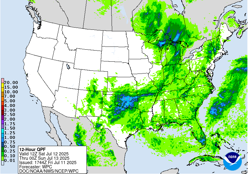
Valid 12Z Sat Jul 12 2025 - 12Z Sun Jul 13 2025
...THERE IS A SLIGHT RISK OF EXCESSIVE RAINFALL FOR PORTIONS OF THE
SOUTHERN PLAINS...
As the northern stream shortwave that will bring heavy rainfall to
portions of the Midwest Friday pushes into the Great Lakes, the
southern end of that shortwave trough will get hung up across the
southern Plains. The trough will be supported by convection on the
nose of a potent LLJ transporting abundant Gulf moisture across
much of Texas and Oklahoma. This will allow a secondary shortwave
to develop, only moving very slowly across north Texas and Oklahoma
on Saturday. Early morning convection may be ongoing in the area at
the start of the period, which will likely weaken through the
morning. New convection will develop with typical peak afternoon
heating across north Texas and Oklahoma. Coverage and intensity
will peak across the area Saturday afternoon. Light and variable
steering flow will cause numerous storm interactions as clusters of
storms move in differing directions, greatly increasing the
likelihood for interactions between storms. Variability in the
placement of the storms is high in general, but there is some
agreement that by the overnight hours, the focus will be in far
northern Texas/southern Panhandle. This will likely keep the focus
of heaviest rain in the Childress/Wichita Falls area, generally
east of Lubbock and southwest of Oklahoma City. This area is in a
higher-end Slight, with considerable potential for a possible
Moderate Risk upgrade in the coming days, as this includes some
hard-hit areas from recent heavy rains.
There is considerable uncertainty as to exactly where the heaviest
and most persistent storms will form, but the general consensus is
to keep most of the rain north of the hardest hit areas of Kerr
County. That said, there are at least a few of the high-resolution
models suggesting heavy rain will get that far south, so the area
remains in a Marginal to Slight risk. Residents and first
responders should keep a close eye on the forecast over the next 24
hours.
Wegman
Day 2 threat area:
www.wpc.ncep.noaa.gov/qpf/98epoints.txt
Excessive Rainfall Discussion
NWS Weather Prediction Center College Park MD
1153 AM EDT Fri Jul 11 2025
Day 3
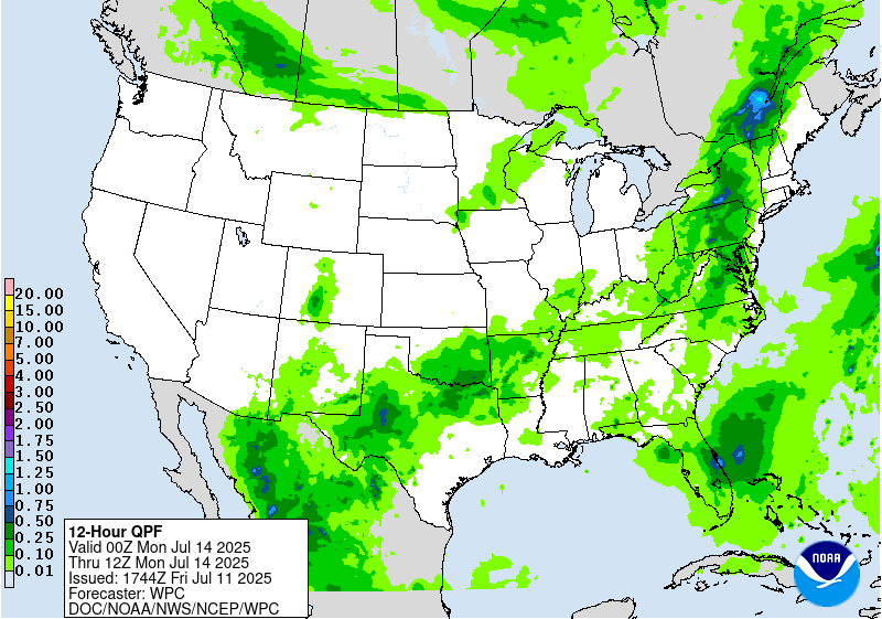
Valid 12Z Sun Jul 13 2025 - 12Z Mon Jul 14 2025
...THERE IS A SLIGHT RISK OF EXCESSIVE RAINFALL FOR PORTIONS OF THE
SOUTHERN PLAINS AS WELL AS FOR PORTIONS OF THE MID-ATLANTIC...
...Southern Plains...
A Slight Risk of excessive rainfall is in effect for many of the
same areas highlighted in the Day 2/Saturday ERO, for much of
northern Texas and Oklahoma. For now, rainfall amounts come down
quite a bit on Sunday as compared to Saturday. Thus, the flooding
potential will be significantly dependent on how the forecast
rainfall compares with Saturday, as well as how much rain actually
falls in the Slight Risk area on Saturday. Thus, for now, a Slight
Risk upgrade was introduced due to the likelihood for additional
strong thunderstorms in this area. Atmospheric moisture amounts
will increase on Sunday as compared with Saturday. The upper level
shortwave that forced the storms on Saturday will likely get left
behind and cutoff from the primary jet flow on Sunday. This slow
moving drift of the forcing should allow the storms to also remain
slow moving, and with increased moisture, the heavy rain potential
will very much still be in place on Sunday. Thus, there is some
expectation that forecast rainfall amounts in this area will
increase with time. Should this continue to be in the same area as
Saturday's storms, then it's likely additional upgrades will be
needed with future updates.
...Mid-Atlantic...
The shortwave that brought heavy rains across the Midwest on Friday
and Saturday will continue into the Mid-Atlantic and Northeast on
Sunday. By Sunday the shortwave will be lifting northeastward and
becoming more negatively tilted. This will increase the associated
divergence and lift. Meanwhile, plentiful Gulf/Atlantic moisture
will stream northward ahead of the shortwave, as PWATs in some
areas exceed 2 inches. This very high level of atmospheric moisture
will support a renewed round of heavy rain from strong
thunderstorms from the DMV north across much of Pennsylvania and
upstate New York. For New York, being both at the nose of the low
level jet and in the area of greatest upper level forcing will
further increase the likelihood for training heavy thunderstorms.
Meanwhile in the DMV, while overall coverage of storms will be
lesser, given the recent storms (and likely isolated to widely
scattered coverage both Friday and Saturday), a Slight Risk was
introduced for this portion of the Mid-Atlantic. The greatest flash
flooding potential will be up towards the eastern Finger
Lakes/Central New York, and additional upgrades in this area appear
likely, especially with low FFGs already in place.
Wegman
Day 3 threat area:
www.wpc.ncep.noaa.gov/qpf/99epoints.txt


