Excessive Rainfall Discussion
NWS Weather Prediction Center College Park MD
900 PM EDT Thu Jul 10 2025
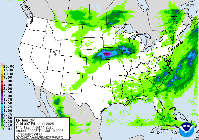
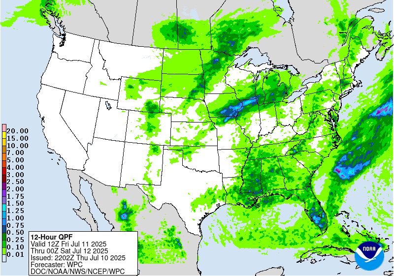
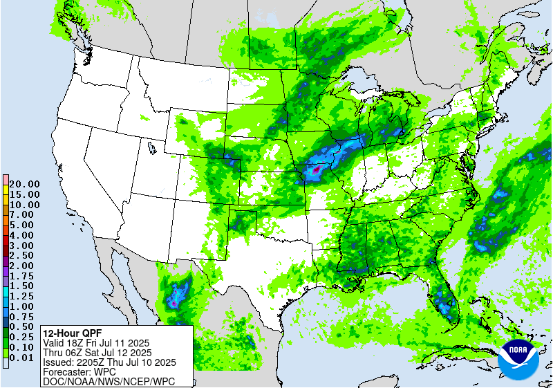
Day 1
Valid 01Z Fri Jul 11 2025 - 12Z Fri Jul 11 2025
...THERE IS A SLIGHT RISK OF EXCESSIVE RAINFALL FOR PORTIONS OF NEW
ENGLAND, THE MID ATLANTIC, AND THE CENTRAL PLAINS INTO THE
MIDWEST...
01Z Excessive Rainfall Discussion...
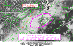
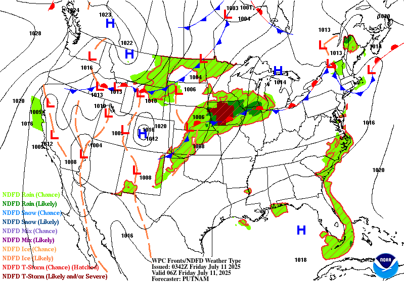
Focus will be across portions of the Upper Midwest and Northern
Plains for excessive rainfall during the overnight hours. Loosely
organized convection over Nebraska this evening is expected to
build into an MCS across the eastern part of the state as mid-level
height falls make their way out over the plains from the
Rockies...and as a low level jet develops in the conveyor belt east
of a low pressure center over western/central Nebraska. This
precipitable water values climb into the 1.8- and 2.1 and draws
deeper moisture into the region overnight. The environment should
foster maximum rainfall rates of 1 to 2 inches per hour with
isolated maximum rainfall amounts through 12Z approaching 3 to 5
inches. This would be in addition to how much rainfall that a
leading shortwave trough can generate/support ahead of the system
in Nebraska.
Maintained a small Slight Risk area in a portion of eastern
Carolina mainly through the late evening where precipitable water
values linger at or above 2 inches and convection was approaching
from the southwest in association with a weak shortwave seen in
satellite imagery.
Trends in short-term satellite and radar imagery supported removal
of the Marginal and Slight risk areas elsewhere.
Bann
Previous Excessive Rainfall Discussion...
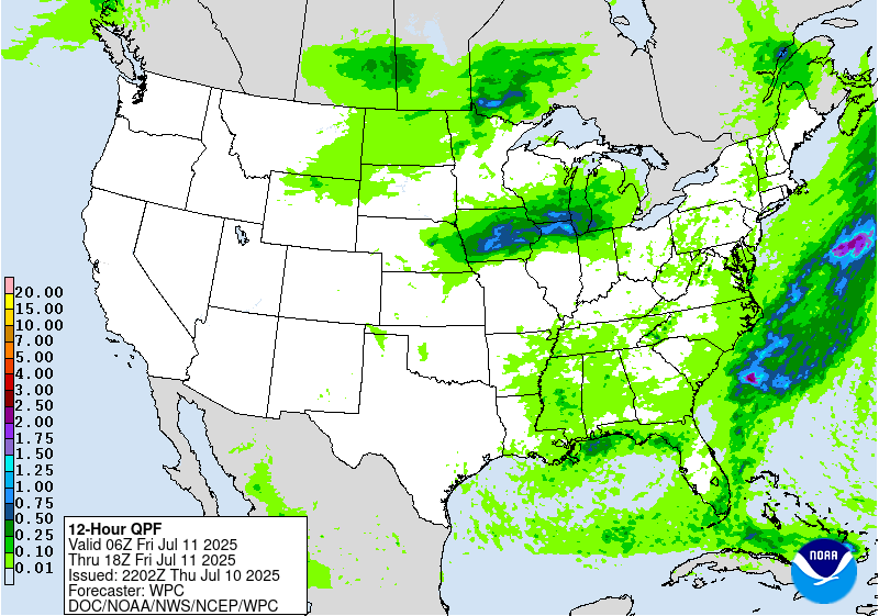
...New England...
The earlier flash flooding over southern New England has largely
waned over portions of Massachusetts as expected with the threat
of intense rain rates and flash flooding subsiding. The Slight Risk
was therefore dropped. Locally heavier rain will still be a threat
for a few more hours, but any flash flooding will be isolated and
likely confined to mainly urban areas.
For Vermont, a weak shortwave trough combined with modest amounts
of moisture and growing instability should support scattered to
numerous showers and thunderstorms through the early evening across
much of Vermont today. Storm motions will be slow, at least
initially, and will be capable of intense rain rates between
1-2"/hr at times. The overnight CAMS and now the latest 12Z runs do
show potential for pockets of 2-4" totals with enough coverage to
warrant an introduction of a Slight Risk for scattered instances of
flash flooding.
---previous discussion---
A Slight Risk was introduced overnight to portions of east-central
MA and surrounding portions of RI/CT, as highly anomalous moisture
(PWs near 2.0", near the 99th percentile per CFSR climatology) has
been supporting very efficient (but so far quite localized) hourly
rainfall totals of 1-2" (with as much as 1" in 15-min). This is
occurring on the northern/western periphery of an MCS tracking
that is tracking across southeast MA, supported by idealized
placement in the right-entrance region of a ~100 kt jet streak (at
250 mb) centered over northern New England/southern Quebec. While
the best low-level (925-850 mb) moisture transport with the LLJ is
located along/offshore with the MCS itself, this jet should veer
into the morning hours and allow for a short period of better
moisture transport into eastern CT/MA and RI. This should continue
the risk of scattered flash flooding at least a bit beyond 12z, as
RAP isentropic analysis indicates some of the best moisture
transport (isentropic lift/upglide) through the 925-700 mb layer
(295-305K isentropic surfaces). This upglide and resultant
slantwise instability may be sufficient to overcome a lack of
vertical instability for a period (though RAP analysis is still
indicating a bubble of 500-1000 J/kg of SBCAPE at 08z). The tail
end of this upglide may be positioned near the Boston metro area
between 12-15z, and some CAMs suggest the potential for localized
2-4" totals from these training showers (as indicated by both the
00z HREF and experimental RRFS PMM QPF fields). Given 3-hr FFGs in
the vicinity of Boston near 2.0", there may be a localized
instance of more significant flash flooding (primarily in more
vulnerable low- lying areas of the metro).
...Mid-Atlantic and Appalachians into the Southeast...
The Slight Risk was extended further across southeast Virginia
where probabilities for impactful rainfall totals and intense rain
rates have come up since the overnight cycle, otherwise the rest of
the Slight Risk across the Carolinas and central VA looks in good
shape given the expected coverage and intensity of thunderstorms
this afternoon/evening relative to the antecedent soil conditions
as well.
---previous discussion---
A shortwave trough situated over southern Quebec begins to lift
eastward today, but is slow to do so as it slogs through larger
scale ridging. Vorticity streamers trailing the upper trough may
allow for some convective organization today, though the highest
coverage and best rainfall rates are expected to be relegated to
southern portions of the Mid-Atlantic and into the Southeast (where
anomalous tropospheric moisture will also be on the downtrend, but
PWs still near 2.0" are around the 90th percentile per CFSR climo).
Ridging is expected to amplify in the wake of the departing SW, and
this will eventually result in height rises aloft that will be less
amenable to organized deep convection. As a result, expect a fair
bit less convective coverage today overall (particularly in more
northern portions of the Mid-Atlantic, perhaps with the exception
of the far northern Appalachians in NY/VT/NH where the closer
proximity of the lifting shortwave may provide better localized
uplift via DPVA and height falls with peak daytime heating). The
inherited Slight risk was generally maintained for much of VA/NC
and into SC (though the southern eastern portions of the Slight
have a greater risk of localized 5" exceedance, per 00z HREF
neighborhood probs near 10%, while the northern/western portions
are more sensitive with lower FFGs having had localized 3-5" totals
over prior days).
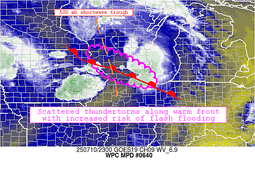
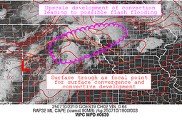
...Northern and Central Plains into the Upper Midwest...
Convective organization has been quite impressive overnight across
SD/NE/MN/IA, as storms tapped into the favorable left-exit region
of a subtropical jet streak (~90 kts at 250 mb) on the northern
periphery of an upper-level ridge that has been situated over the
Southwest U.S. and northwestern Mexico. The main shortwave
responsible for this jet streak has yet to move into the Plains,
but will do so today as it digs from the Intermountain West into
the Central Rockies and High Plains. Convection should fire once
again today, likely organizing and growing upscale over the Central
Plains with peak daytime heating this afternoon and evening. CAMs
suggest these storms may train favorably from west-to-east over
portions of NE/IA, while farther east an MCV from the storms
overnight will likely reinitiate convection with daytime heating
with the potential for backbuilding storms resulting in training
and repeating along a north/south axis from northwest IL through
southwest WI (though confidence in this scenario is a bit lower,
but has been impressively indicated for days by the ECMWF and its
accompanying AIFS solutions). PWs are generally near or above the
90th percentile across this whole region, though rainfall is badly
needed in some locations where moderate to severe drought is
present. Unfortunately too much rainfall too quickly may result in
scattered instances of flash flooding, as 1-2"/hr rates drive a
localized threat for 4-6" totals where storms are able to train and
repeat.
Churchill/Taylor
Day 1 threat area:
www.wpc.ncep.noaa.gov/qpf/94epoints.txt
Excessive Rainfall Discussion
NWS Weather Prediction Center College Park MD
900 PM EDT Thu Jul 10 2025
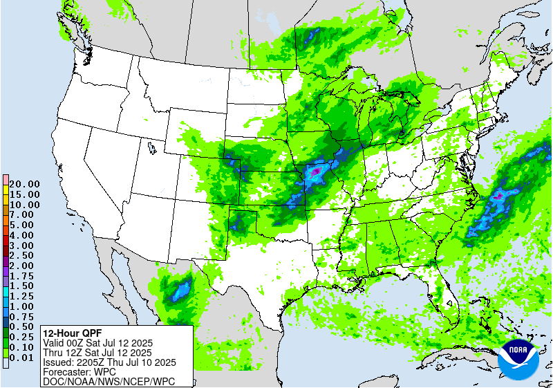
Day 2
Valid 12Z Fri Jul 11 2025 - 12Z Sat Jul 12 2025
...THERE IS A SLIGHT RISK OF EXCESSIVE RAINFALL OVER PORTIONS OF
THE UPPER MIDWEST, THE MID-MISSISSIPPI VALLEY AND EASTERN CENTRAL
PLAINS...
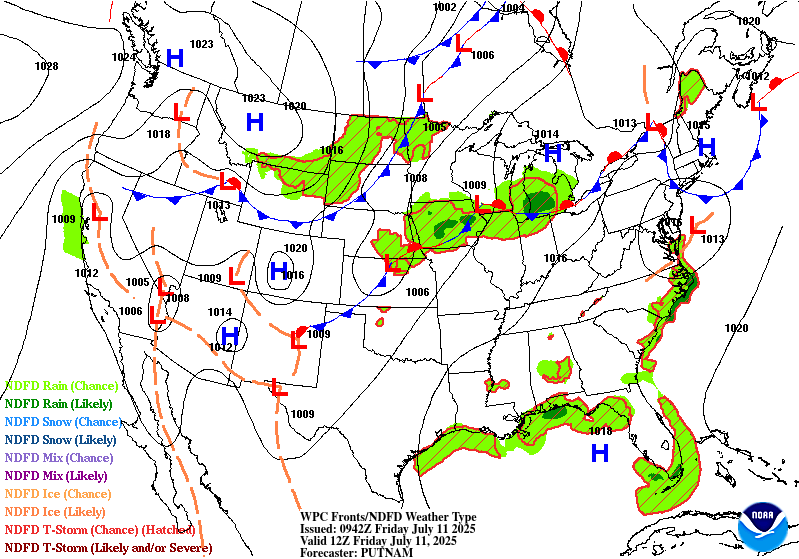
...Upper Midwest into Mid-Mississippi Valley...
Two waves of training convection are expected during the period,
one being a continuation from the day 1 period (late tonight into
early Friday morning) as a west to east oriented band of showers
and thunderstorms is expected across portions of Iowa and northern
Illinois. With the waning low-level jet early Friday morning, this
activity should begin to diminish by mid-morning but may still be
producing some flash flooding, particularly over northern Illinois.
A break in the action is then expected before another round
develops in the afternoon into the evening hours. Activity is
likely to ignite on the existing boundary over eastern IA and
northern IL early to mid afternoon then additional storms to
develop southwestward into northern MO. Training and backbuilding
storms are of concern and some of this activity could fall on
similar areas as Thursday, so some concern for locally significant
flooding. The Slight Risk was expanded further east into the
Chicagoland area.
Further north, there is lower confidence on the coverage and
intensity of any thunderstorms that develop across the eastern
Dakotas into Minnesota. While some isolated flash flooding will be
possible, the trend in the guidance had lowered enough to remove
portions of the Slight Risk area in that area.
---previous discussion---
Another shortwave trough is progged to dig southward from south-
central Canada into the Northern Plains, merging with the separate
aforementioned shortwave that stalled out near the Central Plains
and Mid-Mississippi Valley. This will result in a much larger area
of organized convection on Friday and Friday night, and the best
axis looks to be positioned from central/eastern IA into southwest
WI (as this is the best model consensus and positioning of the
ECMWF and AIFS in particular, but there is still considerable
uncertainty with regard to the nuance of how these shortwaves
evolve/interact and where the highest totals ultimately fall).
Similar to Day 1, anomalous moisture (PWs of 90th percentile or
higher) looks to be in place prior to the arrival of drier, much
more stable air behind the accompanying cold front (which is
expected to sweep through the Northern Plains and into the Central
Plains and Upper Midwest late into the overnight). While much of
the rainfall will be beneficial for the region overall, the
inherited Slight Risk was expanded rather significantly. Future
targeted upgrades to Moderate Risk are possible, depending on what
transpires on Day 1 and how much overlap there is with additional
localized totals of 3-5" on Day 2.
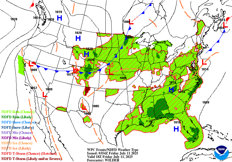
...Appalachians and Mid-Atlantic into the Southeast...
As mid-level troughing becomes more established in the Northern
Plains into Day 2, and ridging/height rises build in response
downstream and may finally begin to suppress convection more
significantly across the Mid-Atlantic into the Northeast. While
overall intensity and coverage of convection should be drastically
lower compared to prior days, convective initiation is still
expected across the higher terrain of the Appalachians and along
the sea breeze of the Carolinas and bay breeze of the Chesapeake.
Some convection may propagate and/or initiate in areas inbetween,
and maintained a Marginal Risk as a result (also including areas of
the Southeast where slow moving, largely short-lived storms with
efficient rainfall rates of 1-3"/hr may present a localized flash
flood risk as well).
...Rockies into the Central and Southern High Plains...
As the Southwest upper-level ridge erodes tonight into early
Friday, there should be substantially more convective coverage
across much of the Rockies and into the Central and Southern High
Plains coincident with peak daytime heating. Organization looks
most likely over eastern CO and adjacent portions of WY/NE/KS, but
is likely to propagate into the Southern High Plains as well (as
northwest flow becomes established with shortwave impulses rippling
south, getting tugged around the upper-level ridge retreating
westward towards Southern California). Localized 1-2" totals (which
have been continually indicated by both downscaled deterministic
GFS/ECMWF solutions and ensemble 1" exceedance probabilities) in
the sensitive terrain may lead to localized flash flooding
concerns. Should more substantial convective organization occur or
confidence increases in the placement of the convection evolution
grows, a Slight Risk may be needed for the next update.
Churchill/Taylor
Day 2 threat area:
www.wpc.ncep.noaa.gov/qpf/98epoints.txt
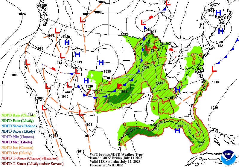
Excessive Rainfall Discussion
NWS Weather Prediction Center College Park MD
900 PM EDT Thu Jul 10 2025
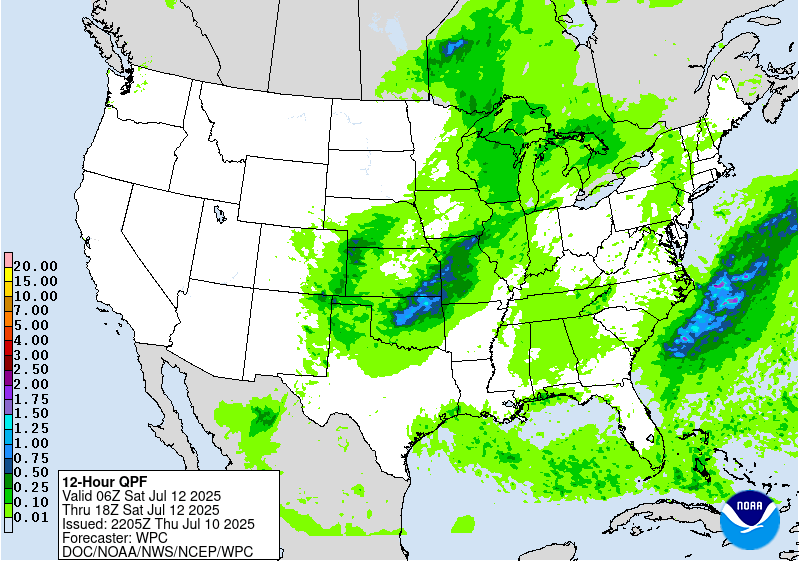
Day 3
Valid 12Z Sat Jul 12 2025 - 12Z Sun Jul 13 2025
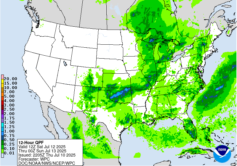
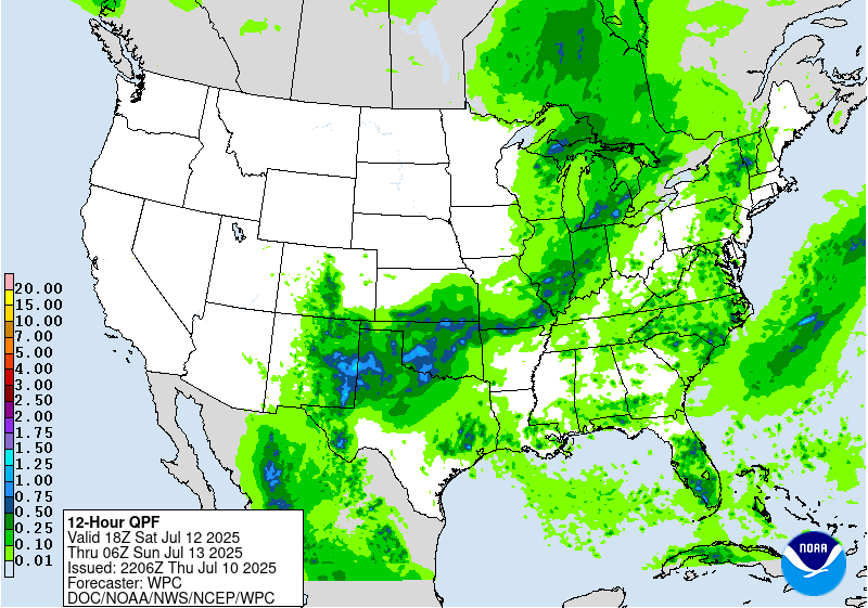
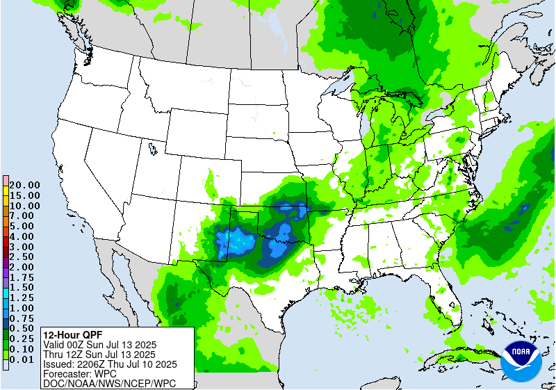
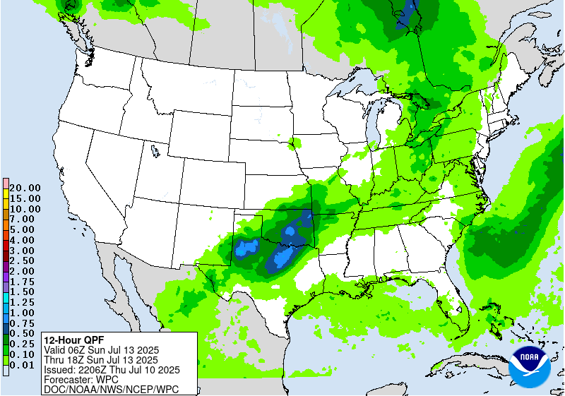
...THERE IS A SLIGHT RISK OF EXCESSIVE RAINFALL OVER MUCH OF THE
SOUTHERN PLAINS INTO THE OZARKS...
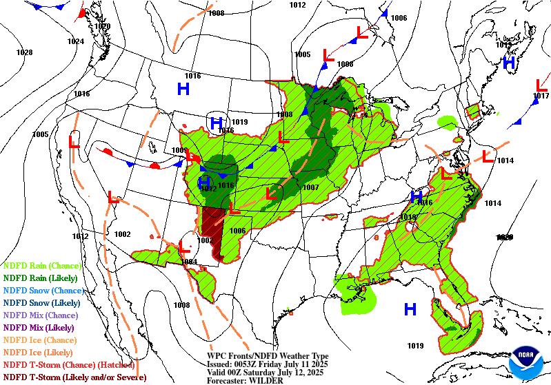
...Southern Plains into the Ozarks...
The threat for more organized convection developing on Day 3
continues to grow, stemming from a subtle shortwave/upper-level
low forming and stalling out over the Southern High Plains. The
bulk of the global guidance generally indicates this scenario, and
the ECMWF suite (including the ECENS and AIFS) are of particular
concern with the most robust signal of the models (with the AIFS
continuing to have a southward shift of best QPF signal, near the
more sensitive areas of central/North TX). A large Slight Risk was
largely unchanged from the previous cycle, encompassing the area
where organized convective activity is expected to occur, though
many of the details will still need to be ironed out as we enter
the hi- res CAM period. In the meantime, the combination of already
saturated soils and terrain sensitivities across the broader
region with highly anomalous tropospheric moisture (PWs of 2.0"+
expected, near 90th percentile) is justification for a broad Slight
Risk that can be more fine tuned in subsequent cycles.
...Upper Midwest, Great Lakes into Ohio Valley...
Convection should become less abundant into Day 3 in association
with the consolidated shortwave from Day 2, as it lifts into Canada
and forcing becomes less impressive overall (though still located
within a favorable right-entrance region of an attendant jet
streak). Daytime heating will likely drive the main threat with
short-term localized totals of 1-3" possibly resulting in isolated
flash flooding.
...Appalachians and Mid-Atlantic into the Northeast...
A broad Marginal Risk area continues into Day 3, as localized
downpours (1-2" hourly amounts) in association with daytime
heating present an isolated risk of flash flooding similar to the
prior day. Coverage and intensity may increase a bit, based on the
consensus guidance, but remains questionable as ridging aloft may
continue to tamp down on convection.
Churchill/Taylor
Day 3 threat area:
www.wpc.ncep.noaa.gov/qpf/99epoints.txt
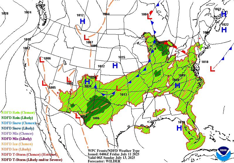
Extended Forecast Discussion
NWS Weather Prediction Center College Park MD
314 PM EDT Thu Jul 10 2025
A frontal system from a trough drifting east from the central Great
Lakes on Sunday will provide a focus for convection from Upstate
New York through the Ohio Valley, the Mid-South, southern Plains,
to west Texas and the southern Rockies. A Day 4 Marginal Risk is
maintained across this area with a shift eastward to the Northeast
per updated consensus on a faster timing. Similar conditions are
expected for Day 5 with a further shift east for the Northeast,
with a repeat for the Mid-South, southern Plains, west Texas, and
southeast New Mexico where the Marginal Risk was expanded through.
Abundant moisture will feed into Florida beginning Sunday, but
increasing by Monday thanks to a broad subtropical ridge.
Heavier than normal diurnal activity can be expected there through
at least Thursday with risks for flash ponding/flooding. The Day 4
Marginal Risk was shrunk a bit based on less coverage/intensity
forecast, but it is maintained for Day 5 (with an expectation for
at least a Marginal Risk for what is currently Days 6/7).
A second frontal system is anticipated to enter the north-central
states early next week and will usher in the next round of rain
and below normal temperatures. Given the recent rains across parts
of the Dakotas and Minnesota, soils require less moisture before
rain becomes excessive. The Day 5 Marginal Risk area for this part
of the country was expanded a bit given the 12Z guidance consensus.
Hot weather will remain for much of the western U.S. through
Monday as upper ridging persists. Daily maximums will be above
normal with many locations climbing into the 100s and 110s for the
Desert Southwest, and nearing/exceeding 100F farther north in
interior/lower elevation areas of the Great Basin.
However, as a trough develops over the northern Rockies late
Monday, temperatures will quickly drop below normal for the
northern Plains where current projections are for high temperatures
15 to 25 degrees below normal for Tuesday and Wednesday.
Temperatures look to be a few degrees cooler than average for the
south- central U.S. for much of next week as clouds and rain hold
temperatures down. The Northeast will see a return to above normal
temperatures on Tuesday after the trough clears. Meanwhile the
Southeast should be near normal to a few degrees above, for typical
summer heat and humidity.
Jackson


