Excessive Rainfall Discussion
NWS Weather Prediction Center College Park MD
817 PM EDT Sat Jul 12 2025
Day 1
Valid 01Z Sun Jul 13 2025 - 12Z Sun Jul 13 2025
...THERE IS A MODERATE RISK OF EXCESSIVE RAINFALL FOR PORTIONS OF
THE TEXAS HILL COUNTRY AND CONCHO VALLEY...
...New Mexico and the Southern Plains...
A sharp upper level trough is moving through the Southern High
Plains at the present time. An MCV is also apparent from daytime
convection across central TX, drifting eastward. Weaker shortwaves
aloft are moving up the east side of the sharp upper trough.
Overall, these features are expected to enhance lift/upper level
outflow across the Southern Plains and Arkansas.
Precipitable water values approach 2" across the region, roughly
0.50-0.75" below where they were 6-9 days ago, but more than
sufficient for heavy rainfall concerns due to the tall, skinny CAPE
within such saturated environments. ML CAPE across the region is
2000-3000 J/kg, which in southern portions of the risk areas
should be maintained by the low-level jet overnight.
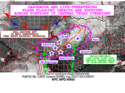
The TX Hill Country and Concho Valley are the primary concern.
Flash flood guidance values remain somewhat depressed by the heavy
rain event a week or so ago, and the 12z RRFS/18z HREF advertise
~30% of 8"+ in the 12 hour period ending at 12z. The last couple
Canadian Regional/HRRR runs advertise 10"+ during this time frame.
The available ingredients suggest that hourly rain amounts to 3"
with local amounts to 9" should be expected, and a new Moderate
Risk area has been added for this expectation, which has been
coordinated with the forecast offices in this region, particularly
EWX/New Braunfels TX and SJT/San Angelo TX where much of the new
Moderate Risk area lies. The first four hours of overnight
convective growth are the potential big rainfall problem, as it
could take that long for a cold pool to become established and
eventually lead to propagation to the east and southeast. Flashy
rivers like the Guadalupe should be avoided, if at all possible.
High Risk impacts cannot be ruled out locally.
...East of the Mississippi River...
Active convection will mostly tone down by midnight. Some activity
will linger in the vicinity of a mobile front across the Northeast.
The Marginal Risk in this region was left for these reasons.
Roth
Day 1 threat area:
www.wpc.ncep.noaa.gov/qpf/94epoints.txt
Excessive Rainfall Discussion
NWS Weather Prediction Center College Park MD
410 AM EDT Sun Jul 13 2025
Day 1
Valid 12Z Sun Jul 13 2025 - 12Z Mon Jul 14 2025
...THERE IS A SLIGHT RISK OF EXCESSIVE RAINFALL FOR PORTIONS OF NEW
MEXICO, THE SOUTHERN PLAINS, AND THE MID- ATLANTIC...
...Southern Plains...
Sunday morning begins and it is likely that convection, some of
which will be strong with heavy rainfall rates, will be ongoing
across parts of Texas. This will be in response to a potent and
convectively enhanced shortwave/vorticity maxima that will be
pivoting across the state. This shortwave will be embedded within a
weakness in the mid-level pattern between ridges both to the west
and east, basically becoming trapped within a weak col across
Texas. As the day progresses, this vorticity maxima should become
strung out and aligned more SW to NE as the mid-level trough axis
tries to swing eastward. While this will likely push some PVA
northeast into Oklahoma and the Ozarks, a ribbon of vorticity may
remain trapped back across Texas, leading to a corridor of enhanced
ascent, aided by at least modest upper diffluence during the
afternoon as a weak jet streak pivots across the middle of the
country.
At the surface, this trough axis will attempt to push a surface cold
front beneath it steadily to the east. However, it is likely this
front will oscillate a bit north and south in response to varying
and increasing low-level flow. Low-level return flow out of the Gulf
will gradually veer from SE to SW, reaching 15-25 kts, and pushing
PWs to as high as 2 inches. This anomalous moisture (PW anomalies
+1.5 to +2 sigma according to the GFS) will merge into the wavering
front, causing its oscillatory behavior, while additionally
transporting more impressive MUCAPE northward through the day and
night (reaching above 2000 J/kg at times).
With forcing for ascent remaining robust through the period, this
will result in waves of convection generally along the front, but
the CAMs are generally scattered as to where the heaviest rainfall
will occur due to differences in frontal placement and the weak
mid- level impulses. However, the impressive thermodynamics in
place will support heavy rain rates that will likely (>50% chance)
exceed 1"/hr, with short term rates of 3-4"/hr possible at times.
Utilizing both the HREF and REFS ensembles, the greatest chance for
more than 3" of rain appears to be focused from the Hill Country
of Texas northeast into the St. Louis, MO metro area, and the
slight risks have been adjusted from inherited in these areas.
There continues to be a signal in the guidance leading to a
somewhat higher potential for flash flooding across portions of
the Texas Hill Country northeast towards the Dallas metroplex. HREF
and REFS probabilities for 5"/24hrs peak around 30-40% in this
region, and this will be on top of heavy rain that is occurring
overnight (before 12Z Sunday). Briefly considered a MDT risk but
uncertainty in coverage and placement prevents that at this time.
However, there could be some locally significant impacts across
this area if slow moving convection can move effectively across the
more vulnerable areas, and it is possible a D1 upgrade to a MDT
risk may be needed depending on how convection evolves through the
early morning hours.
...New Mexico...
Farther to the west, the westward periphery of the
PW plume emerging from the Gulf will spread into New Mexico,
spreading PWs above 1" (+1 sigma) into the High Plains and into the
terrain of the central part of the state. This PW will overlap with
a ribbon of MUCAPE around 2000 J/kg to support scattered to numerous
thunderstorms developing during peak heating over the higher
terrain. These storms will initially move slowly on 0-6km mean winds
of just 5 kts, but the presence of 20-25 kts of bulk shear will
help drive modest organization as storms come off the terrain and
drift southward on Corfidi vectors around 10 kts. With rain rates
above 1"/hr likely, this could result in instances of flash
flooding, especially over sensitive terrain features, urban areas,
or burn scars.
...Mid-Atlantic into the Northeast...
Mid-level ridge gradually pulsing northward from the Gulf Coast
will interact with a broad and slow moving trough advecting across
the Great Lakes to produce pinched SWly flow across much of the
eastern CONUS. This will manifest as impressive thermodynamics
being drawn northward from the Mid-Atlantic into interior portions
of the Northeast. These thermodynamics will be characterized by PWs
of 1.75 to 2.0 inches (90th - 99th percentile according to NAEFS)
and collocated MUCAPE of 1000-2000 J/kg to produce an environment
favorable for heavy rain. Into this environment, a cold front,
pushed slowly eastward by the mid-level trough to the west, will
combine with slow height falls to drive pronounced ascent, creating
scattered to numerous thunderstorms from the eastern Ohio Valley
into Northern New England.
These storms will contain heavy rain rates that have a 30-50% chance
of exceeding 1"/hr with brief 2+"/hr rates also possible. Although
bulk shear is progged to be minimal such that convection will
generally remain of the pulse variety, brief training as 0-6 km mean
winds aligns to the front will allow for some longer duration of
this heavy rainfall in a few areas, leading to HREF and REFS 24-hr
probabilities that peak above 70% for 3". While it is difficult even
at this time range to identify the areas most at-risk to flash
flooding due to uncertainty in exact convective placement, 0-10cm
soil moisture is above the 90th percentile according to NASA SPoRT
from central VA through Upstate NY, which is also collocated with
the locally higher ensemble probabilities. This suggests that the
inherited SLGT risk is warranted, and only adjusted cosmetically
for new guidance, although there is a signal in the guidance for
some locally heavier rainfall across the Finger Lakes region of NY
due to repeating/backbuilding cells which could result in some
locally more substantial impacts.
...Florida...
Slow moving 500mb trough east of Florida will strengthen gradually
as it drifts W/SW today. The accompanying vorticity maxima will
provide some locally enhanced forcing to the eastern side of FL,
while the entire peninsula remains sandwiched between this and a
ridge to the west, producing northerly flow across the area. As the
vort swings westward, some locally enhanced diffluence will
develop aloft as well, and as this occurs in the presence of PWs
above 2 inches collocated with MUCAPE of 2000-3000 J/kg, widespread
convection with heavy rain will result. CAMs suggest storms will
fire on the E/NE side of the peninsula and then drift SW, with some
locally enhanced organization possible into clusters thanks to
20-30 kts of bulk shear. With rain rates progged by the HREF to
have a 30-50% chance of exceeding 2"/hr, this could result in total
rainfall of 3-4", locally higher, as suggested by 24- HREF/REFS
probabilities and PMM. Where this rain occurs over more urban
areas, local flash flooding could result.
Weiss
Day 1 threat area:
www.wpc.ncep.noaa.gov/qpf/94epoints.txt
Excessive Rainfall Discussion
NWS Weather Prediction Center College Park MD
410 AM EDT Sun Jul 13 2025
Day 2
Valid 12Z Mon Jul 14 2025 - 12Z Tue Jul 15 2025
..THERE IS A SLIGHT RISK OF EXCESSIVE RAINFALL FOR THE
FLORIDA PENINSULA AND PORTIONS OF THE MID-ATLANTIC STATES...
...Florida...
The westward-advancing and deepening mid-level wave will reach the
FL peninsula on Tuesday, providing widespread increasing ascent
across the state. In addition to the height falls/PVA accompanying
this trough, modest upper diffluence will develop as northerly flow
continues, enhancing deep layer lift. This impressive and
amplifying ascent will impinge into intensifying thermodynamics
with PWs surging above 2.25 inches, or above the 90th percentile
according to NAEFS. There continues to be some evolutionary
discrepancies among the various models, but in general the setup
will be favorable for widespread thunderstorms with heavy rainfall,
especially during peak heating when MUCAPE climbs above 2000 J/kg.
The heaviest rainfall will again likely develop across the NE
portion of the peninsula, similar to Sunday, and then track SW
along outflows and any weak low-level convergent boundaries. With
rainfall rates likely eclipsing 2"/hr, some bulk shear 20-30 kts to
help organized convection into clusters, and chaotic/weak storm
motions, total rainfall could exceed 3" in places again on Monday.
The inherited SLGT risk was adjusted slightly, but in general
remains as inherited and over the greatest ensemble probabilities
from the HREF, SREF, and ECMWF EFI.
...Mid-Atlantic States...
A cold front will gradually traverse southeast across the Mid-
Atlantic and Northeast on Monday, with thunderstorms likely
developing along it during the afternoon and evening. This front
will be pushed eastward downstream of an advancing, but weakening,
mid-level trough axis, with the resultant and lingering strung out
vorticity helping to provide additional ascent along the boundary.
This ascent will work into thermodynamics that will be extremely
supportive to heavy rain within thunderstorms, as broad return flow
ahead of the front (SW at 10-15 kts) draws a ribbon of PWs above 2
inches (above the 90th percentile according to NAEFS) and
collocated MUCAPE over 1000 J/kg into New England. This will also
be an area where warm cloud depths are progged to reach extreme
values above 15,000 ft, supporting efficient warm-rain processes
which have a 40% chance of exceeding 2"/hr according to the HREF,
especially in the Mid-Atlantic.
While heavy rain rates are expected within any convection along
this advancing front, in general, storms should be more progressive
with greater latitude. However, there is a signal in the available
guidance for some convection to develop ahead of the front and then
backbuild into the greater thermodynamics across the Mid-Atlantic
region leading to some locally higher ensemble probabilities for
3"/24hrs and a modest but notable ECMWF EFI signal. This area has
also been wet the past 7 days, and soil infiltration capacity is
limited (FFG as low as 1-1.5"/3hrs). For these reasons, a SLGT risk
has been added for Monday, with urban areas and most sensitive soil
regions of VA/MD/PA favored for the greatest potential for
excessive rainfall.
...Desert Southwest through the Ozarks...
The same cold front moving into the Mid-Atlantic Monday will sag
southward but weaken and dissipate across the Southern Plains as it
interacts with slow height rises as a ridge slowly builds from the
south. Despite the weakening front, ascent will remain as a
shortwave and accompanying strung-out vorticity drift over the
area, especially near the Ozarks as it gets trapped within a col
between neighboring high pressures. There will also likely be
other modest vorticity impulses rotating through the flow into the
Southwest to additionally provide locally targeted ascent.
This lift will work into a still very favorable environment to
support heavy rainfall as PWs remain nearly 2 inches into the
Ozarks and above 1" as far as southern Arizona thanks to persistent
moist advection out of the Gulf leading to PW anomalies reaching
above the 90th percentile locally from West TX into NM and near the
Ozarks. These are the locations that may have slightly higher
potential for excessive rainfall on Monday, with slow moving storms
over West Texas/New Mexico (0-6km mean winds 5 kts or less) and
organized convection on 20-30 kts of bulk shear from OK into MO/AR.
However, at this time, despite some modest signals for a locally
enhanced flash flood risk, the MRGL risk remains as confidence is
not higher enough for an upgrade at this time.
...Northern Plains...
Potent but positively tilted shortwave will dig out of British
Columbia and emerge into a belt of pinched westerlies aligned to
the Canada/United States border. This will help elongate a cold
front as it drops southward into the Northern Rockies and Northern
High Plains, producing locally enhanced ascent across the area. A
piece of this vorticity lobe will swing rapidly eastward and
interact with the low-level baroclinic zone, which will intensify
due to warm advection on an 850mb LLJ surging to 30 kts Monday
evening up the Plains, drawing thermodynamics characterized by PWs
of 1-1.25 inches and MUCAPE of 1000 J/kg northward. This will
support scattered thunderstorms Monday night, and although cells
should remain progressive on 0-6km mean winds of 20-25 kts, aligned
Corfidi vectors to the mean wind and the front suggests training
which could produce 1-2" of rainfall and local FFG exceedance.
Weiss
Day 2 threat area:
www.wpc.ncep.noaa.gov/qpf/98epoints.txt
Excessive Rainfall Discussion
NWS Weather Prediction Center College Park MD
410 AM EDT Sun Jul 13 2025
Day 3
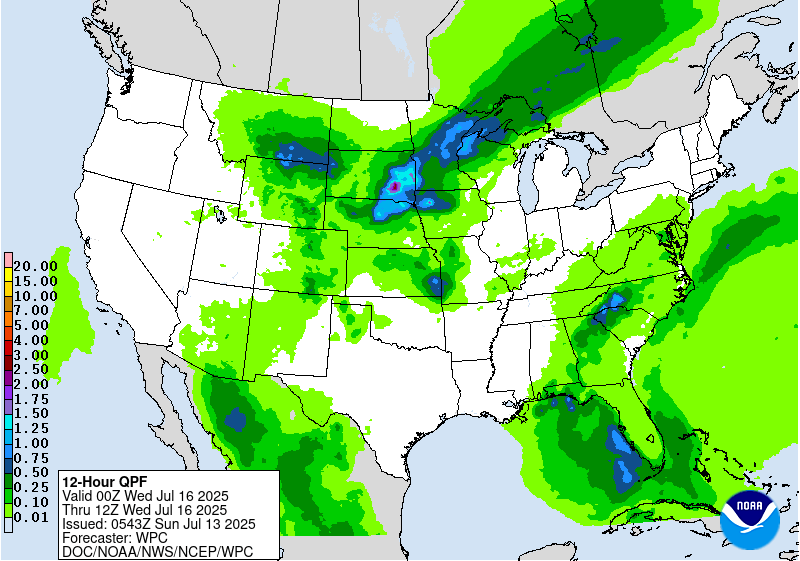
Valid 12Z Tue Jul 15 2025 - 12Z Wed Jul 16 2025
..THERE IS A SLIGHT RISK OF EXCESSIVE RAINFALL FOR THE
SOUTHERN FLORIDA PENINSULA AS WELL AS THE UPPER MIDWEST...
...Florida...
The same mid-level wave traversing the Florida Peninsula on D2 will
continue its westward advance D3, reaching the eastern Gulf Coast
by Wednesday morning. Once again, the ascent accompanying this
feature will act upon impressive thermodynamics, with PWs reaching
2-2.25 inches collocated with MUCAPE above 1000 J/kg. The guidance
suggests that this may manifest as a surface low by D3, (and NHC is
monitoring this area with a low probability of development in the
TWO), which could additionally enhance ascent. As winds behind the
wave turn back to the S/SE across the peninsula, it will likely
result in weakly convergent boundaries upon which thunderstorms
will blossom and track NW with 2+"/hr rates. Where these cells
exhibit even short-term training, especially atop urban areas or
across soils moistened from rainfall on D1 and D2, instances of
flash flooding could result from 2-3" of rain with locally higher
amounts.
...Northern Rockies through the Upper Midwest...
A broad mid-level trough with pinched flow will translate gradually
southeast through D3, within which waves of vorticity will advect.
This will push a cold front, initially aligned generally west-to-
east, to become more SW to NE as it approaches the Upper Midwest
the latter half of the period. Although there remains considerable
placement uncertainty in the axis of heaviest QPF due to
differences in frontal position, the accompanying ascent (driven by
low-level convergence, PVA, and jet-level diffluence) will produce
widespread convection on Tuesday. As the front shifts east, waves
of low pressure may additionally develop along this front,
providing locally enhanced ascent into PWs above the 90th
percentile according to NAEFS. This will support rainfall rates of
1-2"/hr, with training of echoes likely due to boundary parallel
mean flow.
The greatest potential for heavy rainfall appears to be focused in
northern MN and eastern ND where training along the boundary may be
most efficient, and where ECMWF EFI is highest. However, there is a
secondary max in consensus QPF across eastern SD and northeast NE
where backbuilding/regenerating cells may be more likely. After
coordination with the affected WFOs, despite uncertainty in the
exact placement, a SLGT risk was added for this region.
...Mid-Atlantic and Southeast...
A generally moist and unstable environment will remain across much
of the eastern CONUS Tuesday as broad ridging expands from the
Atlantic. 850mb flow around the offshore ridge will become
increasingly S/SE, surging a ribbon of PWs above 2" from the Gulf
Coast through southern Virginia. Although forcing for ascent will
be modest, widespread showers and thunderstorms are expected, many
of which will have 1-2"/hr rain rates despite their pulse nature.
This has resulted in some minor adjustments to the MRGL risk to
capture the highest GEFS/ECENS probabilities for 1-3" of rainfall
due to the slow moving storms. There is a potential that a SLGT
risk may be needed with future iterations for the Appalachians
where upslope flow may enhance rainfall in western NC and VA, but
confidence at this time is not high enough for an upgrade.
Weiss
Day 3 threat area:
www.wpc.ncep.noaa.gov/qpf/99epoints.txt
Extended Forecast Discussion
NWS Weather Prediction Center College Park MD
257 AM EDT Sun Jul 13 2025
A surface low pressure system (which the National Hurricane Center
is now monitoring with low probabilities of tropical cyclone
development) will be retrograding across Florida into the Gulf by
mid-week. Moisture above the 90th percentile is likely to be in
place and promote multiple inches of rain in the Florida Peninsula
from Monday-Tuesday (short range period) into Wednesday. By The low
should be moving west into the Gulf by Thursday, but enhanced
moisture will remain in place across Florida, and spread into the
central Gulf Coast. A Marginal Risk is included on both the Day
4/Wednesday and Day 5/Thursday Excessive Rainfall Outlook/ERO for
those areas. Heavy rain may linger in the Gulf Coast region into
next weekend.
Much of the nation from the Rockies eastward will be active with
typical summertime convection in a warm and unstable airmass. A
cold front moving through the northern/central Plains and eastward
will support showers and thunderstorms with ample moisture and
instability, resulting in a heavy to excessive rainfall threat. The
ERO on Wednesday shows a broad Marginal Risk area from the Upper
Midwest/Middle Mississippi Valley eastward into the Ohio Valley and
Central Appalachians. On Thursday, the marginal risk ERO shifts
more into the Ohio Valley/Mid-Atlantic and Northeast. Model
guidance varies considerably with placement of heavy rain amounts
on both days, so the Marginal is quite broad in order to cover the
widespread but low- end threat. Some areas may eventually need
embedded Slight Risks in future cycles if models converge on
placement and amounts of heavy rain.
Elsewhere, monsoonal moisture will gradually increase in coverage
across the Southwest/Four Corners/southern Rockies region. Marginal
risks are in place across southern Arizona, New Mexico, and points
north. More widespread monsoonal moisture will continue making its
way northward in this region through next weekend.
Hot weather may linger in the Pacific Northwest through around
midweek, but temperatures in the northern High Plains will cool
dramatically by Wednesday with highs around 15 to 25 degrees below
normal. Temperatures look to be a few degrees cooler than average
for the south-central U.S. for much of next week as clouds and rain
hold temperatures down. The Great Lakes and Northeast will see an
increase in heat next week with a building ridge over the region,
with somewhat widespread Major (level 3/4) HeatRisk showing up in
those areas mid-late week. Meanwhile the Southeast should be near
normal to a few degrees above, for typical summer heat and
humidity.
Santorelli


