Excessive Rainfall Discussion
NWS Weather Prediction Center College Park MD
857 PM EDT Wed Jul 16 2025
Day 1
Valid 01Z Thu Jul 17 2025 - 12Z Thu Jul 17 2025
...THERE IS A SLIGHT RISK OF EXCESSIVE RAINFALL FOR PORTIONS OF
THE MID-ATLANTIC STATES, THE CENTRAL PLAINS, AND THE UPPER
MIDWEST...
...Central High Plains through the Great Lakes...
0100 UTC Update...Continue to remove the western edges of the
Slight and Marginal Risk areas across the Upper Midwest, while have
also made some tweaks to the Slight (removing SE Lower MI) based on
the latest observational and mesoanalysis trends.
...Ohio Valley into the Mid-Atlantic...
0100 UTC Update...Minor adjustments were made to the Slight and
Marginal Risk areas, based on the latest observational and
mesoanalysis trends. 18Z HREF exceedance probabilities again
support the highest risk for any isolated/scattered areas of
excessive rainfall lingering through 04-05Z.
...Gulf Coast...
Invest 93L exiting the northern Florida peninsula this morning
will drift westward into the northern Gulf on Wednesday. The
accompanying mid-level inverted trough/tropical wave will be forced
due west as it remains south of an elongated ridge extending from
the Atlantic Ocean. There continues to be quite a bit of spread of
intensity of the accompanying surface reflection to this feature
(and NHC continues a 40% chance of development) but the track
guidance has converged moving just south of the coast through the
next few days. Regardless of the exact track and development of
this system, the accompanying tropical moisture plume (PWs 2.25 to
2.5 inches, as much as +3 sigma according to the GEFS) will spread
onshore to support showers and thunderstorms with heavy rainfall
rates of 2-3"/hr. There continues to be uncertainty into how far
north any of this moisture will spread due to subsidence/dry air
beneath the ridge to the north, but guidance has begun to focus a
relative maxima across southeast LA, and potentially as far east as
Mobile Bay, AL.
...Arizona and New Mexico...
2015Z Update...Based on the latest observational trends (visible
satellite and mosaic radar in particular), along with the latest
HREF and RRFS 1/3/6hr QPF exceedance probabilities...have expanded
the Marginal to include the Sacramento Mtns in NM. Another update
may be necessary to expand the Marginal north to capture the
convective clusters firing across portions of the Grand Canyon
Country in northern AZ.
Active convection is likely again today across the Southwest as
the mid-level ridge weakens and weak impulses, some of which are
convectively enhanced by thunderstorms from Tuesday, move across
the region. PWs are expected to continue to be above 1.25", highest
across southern AZ, but with a slow decrease in intensity and
coverage of this PW plume. Additionally, probabilities for CAPE
exceeding 500 J/kg are lower and confined east of the greatest
moisture today, indicating that coverage and intensity of
thunderstorms should be less than what occurred Tuesday. Despite
that, convection should still be relatively widespread, but
possibly displaced north of previous activity, although any weak
remnant MCVs could enhance local ascent leading to local flash
flood impacts, most likely should any thunderstorms with 0.5"/hr
rain rates track across burn scars or sensitive terrain.
Hurley/Weiss
Day 1 threat area:
www.wpc.ncep.noaa.gov/qpf/94epoints.txt
Excessive Rainfall Discussion
NWS Weather Prediction Center College Park MD
414 AM EDT Thu Jul 17 2025
Day 1
Valid 12Z Thu Jul 17 2025 - 12Z Fri Jul 18 2025
...THERE IS A MODERATE RISK OF EXCESSIVE RAINFALL FOR THE LOWER
ATCHAFALAYA BASIN IN SOUTH-CENTRAL LOUISIANA...
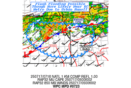
...Northern Gulf Coast...
A highly disorganized tropical disturbance continues tracking west
across the far northern Gulf this morning, with a center off the
coast off Mississippi as of the time of this writing. This
disturbance is responsible for a larger area of thunderstorms well
west of the center, moving across southern Louisiana. The storms
will turn southward and move out into the Gulf through the morning.
More widespread, albeit widely scattered thunderstorm activity
will develop today as the center moves into southeast Louisiana.
Much of the strongest activity is expected to focus west of the
center of circulation, but will push westward as it does so.
Beyond ample atmospheric moisture is in place, with New Orleans
sounding measuring PWATs of 2.27 inches from the 00Z sounding.
Thus, while the storms ongoing over Louisiana are largely sticking
to rainfall rates under 1.5 inches per hour...with ample
instability developing with daytime heating today, any storms that
form will have more than enough instability and moisture available to
locally produce rainfall rates in excess of 3 inches per hour.
However, since the storms will be moving westward, any one location
will see rainfall rates that heavy for only a short time. With FFGs
near their average at 3.5 to 4 inches per hour over much of
Louisiana, it will take repeating rounds of storms to exceed FFGs
enough to induce significant flash flooding. This is likely to be a
high bar to overcome in most areas, as despite the ample moisture
and instability, the forcing associated with this weak, slanted,
and overall disorganized low is very lacking in most areas.
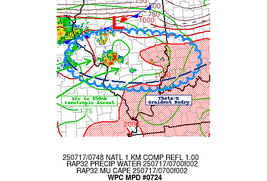
The Moderate Risk includes the Lafayette area and the Lower
Atchafalaya Basin in large part because of the V-shaped nature of
the river basin, heavy rain could funnel into flood prone areas
quickly if the heavy rain over the basin is persistent enough. In
coordination with LCH/Lake Charles, LA forecast office, the
Moderate Risk previously in the Day 2/Friday period was transferred
to today, as the likelihood for more organized convection across
Louisiana will be significantly greater today, resulting in a
greater coverage of heavier rain today than is now expected
tomorrow/Friday.
The surrounding Slight Risk area extends from the far western
Florida Panhandle west along the coast to the Texas border. Many of
the same thunderstorms impacting southeastern Louisiana will
continue west into southwestern Louisiana before dissipating,
resulting in the continuation of the Slight Risk. Any heavy rain
will have to contend with very high FFG values across all of the
Louisiana coast. Meanwhile further east from coastal Mississippi to
the far western Florida Panhandle, the combination of urban areas,
and southerly onshore flow off the Gulf will support a northward
convective motion, favoring training in these areas.
...Ozarks to the Ohio River Valley...
A stalled out front over this region acting as a barrier between
much drier air to the north over the Great Lakes and a hot and very
humid air mass from the Ohio Valley south will act as a focus for
eastward-moving complexes of showers and thunderstorms to develop
and push quickly east as new thunderstorms from to their west. This
will occur over a long line from the central Plains to the central
Appalachians this afternoon and tonight. Persistent southerly flow
of moisture-laden air will support numerous thunderstorms occurring
over these areas today as that southerly flow runs into the stalled
out front and turns eastward. While portions of the Slight Risk
area have seen more prior rains than others...during the day today
expect PWATs routinely over 2 inches to support thunderstorms
capable of up to 3 inch per hour rainfall rates. These heavy
rainfall rates will be offset by their fast movement, but given the
stationary front in place directing all the storms along the same
track...training is likely.
The Slight Risk area was expanded a bit into southeastern Virginia
and northwestern North Carolina with this update, in coordination
with RNK/Blacksburg, VA forecast office. Elsewhere few changes have
been made since the pattern remains steady state.
...Northeastern New Mexico and Adjacent Areas...
Only a very modest eastward shift was made to the previous Slight
Risk area, which is largely centered over northeastern New Mexico,
a southerly LLJ running into both terrain and a thermal low will
act as a focus for rather fast moving thunderstorms to track ESE
out of CO/NM and eventually into the OK/TX Panhandles. Like the
other higher risk areas, southerly flow of moisture will support
backbuilding and additional convective development behind the
initial round of storms. Training over flood-sensitive areas may
result in widely scattered instances of flash flooding this
afternoon into this evening.
Wegman
Day 1 threat area:
www.wpc.ncep.noaa.gov/qpf/94epoints.txt
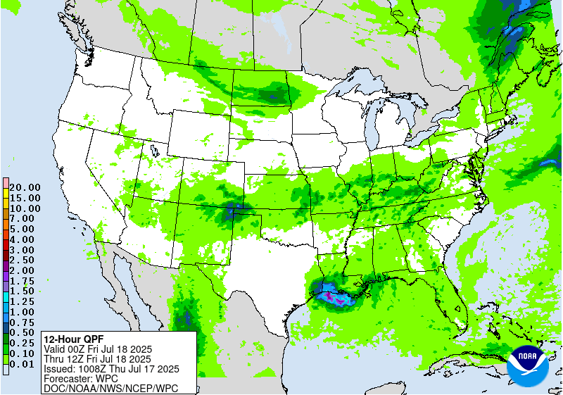
Excessive Rainfall Discussion
NWS Weather Prediction Center College Park MD
414 AM EDT Thu Jul 17 2025
Day 2
Valid 12Z Fri Jul 18 2025 - 12Z Sat Jul 19 2025
...THERE IS A SLIGHT RISK OF EXCESSIVE RAINFALL FOR PORTIONS OF THE
CENTRAL GULF COAST, MID-ATLANTIC, AND THE UPPER MIDWEST...
...Central Gulf Coast...
The center of circulation of a tropical disturbance over south-
central Louisiana will stall out early Friday morning and turn
north through much of the Day 2/Friday period. Much of the guidance
and the official rainfall forecast have 2 distinct maxima of total
rainfall Friday and Friday night: One is over western Louisiana,
with a second into the Mississippi and Alabama Gulf Coasts. While
these are maxima, in most cases rainfall amounts will hold between
2 and 4 inches for the day. As mentioned in the Day 1/Thursday ERO
discussion, the tropical disturbance will simply be too weak and
disorganized to support sustained convection for more than a few
hours. Despite help from daytime heating and with ample atmospheric
moisture, without a well-defined source of forcing, the guidance
and the forecast generally agree that the convection will be highly
disorganized in clusters that are most likely to track over those
two aforementioned maximum areas, but could just as easily form in
other areas, rain heavily, then collapse and weaken. New storms may
form in similar areas, but once again they will remain widely
scattered. PWATs of 2.25 inches and higher will still support any
storms that can form to be capable of short bursts of very heavy
rainfall of 3+ inches per hour. The disorganized nature of the
storms may still support multiple separate clusters moving over the
same unfortunate area, resulting in highly localized double digit
rainfall totals. However, it is impossible at this point to
pinpoint any one area that is likely enough to see 6+ inches of
rain in a large enough area to continue to paint it in a Moderate
Risk area. Thus, while it remains likely localized areas will see
enough heavy rain to cause localized flash flooding, some of which
may be significant, the threat for numerous flash flooding has
continued decreasing due to the disorganized nature of the
disturbance as a whole. Thus, given the paltry signals for heavy
rain that are highly changeable, the inherited Moderate Risk for
western Louisiana was downgraded with this update.
Meanwhile, further east into coastal Mississippi and Alabama,
these areas east of the center of circulation will be under a
predominant southerly flow of deep tropical moisture. With the
center of circulation drifting northward through the period, expect
nearly stationary "bands" of very heavy showers and thunderstorms
to develop as early as the predawn hours Friday. Any "bands" will
have embedded thunderstorms with much heavier rain in between
lighter showers. Given any heavy rain in these areas from the Day
1/Thursday period will likely have saturated the soils in these
largely urbanized areas, the higher likelihood for additional heavy
rainfall into Friday will only worsen the localized flash flooding
threat from Gulfport east through Pensacola, including Mobile. A
higher end Slight is in effect for this area.
...Mid-Atlantic...
A new Slight Risk area was introduced with this update from central
Virginia southeast through the Tidewater and into northeastern
North Carolina with this update. Disturbances from prior
thunderstorms over the Appalachians will track ESE across this
region on Friday. Ample moisture and instability remain in place
from multiple days of showers and thunderstorms over the past few
weeks. Thus, much of this region has very saturated soils that
cannot handle much additional rainfall. Given the front stalled
over this region will act as a focus, the storms will likely form
over western VA and WV, then track southeastward across the Slight
Risk area and into the Carolinas. Additional thunderstorms are
likely to impact eastern areas prior to that, resulting in
multiple rounds of storms impacting the same area in some cases.
While the storms will be fast-moving, which may limit the time of
the heavy rain over any one area, the likelihood of training and
backbuilding thunderstorms could still result in multiple hours of
heavy rain over some areas, resulting in locally significant flash
flooding, especially were this to occur over any urban area.
...Upper Midwest...
Building southerly flow into a stalled out front will result in
scattered convective development over far southern Minnesota and
northwestern Iowa Friday afternoon. While the storms are in their
formative stage...slow movement and cell mergers could result in
widely scattered instances of flash flooding. The storms are likely
to congeal into a line in eastern Iowa, which will increase in
forward speed as the line races southeast into Illinois by Friday
night. Once the line has formed, the flash flooding risk should
decrease since the line will track orthogonal (southeastward) to
its orientation (southwest to northeast). Soils are at or above
average for this time of year in the area, so the heavy rainfall
likely in this area will support any flash flooding due to
excessive runoff.
Wegman
Day 2 threat area:
www.wpc.ncep.noaa.gov/qpf/98epoints.txt
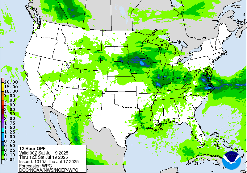
Excessive Rainfall Discussion
NWS Weather Prediction Center College Park MD
414 AM EDT Thu Jul 17 2025
Day 3
Valid 12Z Sat Jul 19 2025 - 12Z Sun Jul 20 2025
...THERE IS A SLIGHT RISK OF EXCESSIVE RAINFALL FOR PORTIONS OF THE
MIDWEST INTO THE MID-ATLANTIC...
Multiple rounds of thunderstorms are likely to impact areas from
Iowa southeast to the VA/NC coast on Saturday. Thunderstorms
ongoing from the Friday night period may impact the Ohio Valley and
central Appalachians Saturday morning. With daytime heating
additional storms will form over much of Virginia, as lines and
other congealing storms move into the Appalachians. Meanwhile an
upper level shortwave will support repeating thunderstorms from
Iowa southeast through Indiana from Saturday afternoon through
Saturday night. All of these are likely to occur over the same
areas hit with strong thunderstorms capable of heavy rainfall on
previous days. Further, the remnants of the tropical disturbance
over the northern Gulf will further add to the moisture available
for storms to use to produce heavy rain over the Midwest. Thus, in
some instances where repeating storms occur, it may not much matter
how saturated the soils are, as the prolonged heavy rain will
result in flash flooding by overcoming the areas where soils are
dry.
The Slight Risk area was expanded into southeastern VA and northern
NC with this update. While confidence isn't quite as high on
D3/Saturday as compared with D2/Friday, the signal for heavy rain,
if reduced from Friday, will still support flash flooding in these
hard hit areas.
...Lower Mississippi Valley...
The inherited Slight Risk area over northern Louisiana was
downgraded to a Marginal with this update. There is good agreement
in the guidance that any remnants of the northern Gulf tropical
disturbance will be dissipated by Saturday, with only showers and
isolated thunderstorms remaining over Louisiana, posing only a
Marginal flash flooding risk at most. The downgrade was
coordinated with SHV/Shreveport, LA forecast office.
Wegman
Day 3 threat area:
www.wpc.ncep.noaa.gov/qpf/99epoints.txt
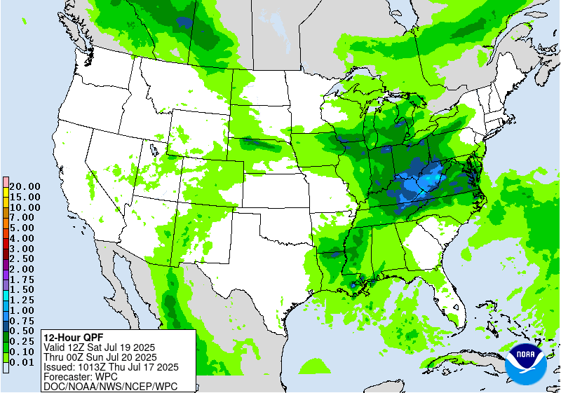
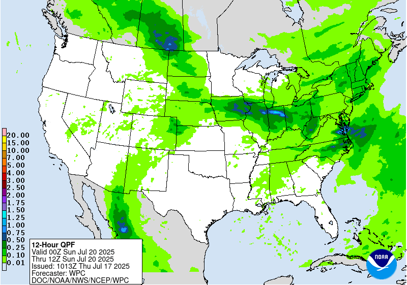
Extended Forecast Discussion
NWS Weather Prediction Center College Park MD
256 AM EDT Thu Jul 17 2025
A series of shortwaves and associated surface fronts through the
northern tier will continue to support showers and thunderstorms
from the northern Plains eastward to the Mid-Atlantic/Southeast.
This entire area is encompassed by broad marginal risks on the
Excessive Rainfall Outlooks (EROs) with the warm and very moist
airmass in place. There continues to be a good signal for heavy
rain and the potential for flash flooding from portions of the
Midwest to the Central Appalachians beginning this weekend at the
end of the short range and lasting into Sunday. For the Day
4/Sunday ERO graphic, a higher-end slight risk is depicted in this
area where thunderstorms could train along a nearly stationary
frontal boundary. It is possible a moderate risk may be needed in
future updates.
Elsewhere, the heavy rainfall threat lessens by Monday onward as
this whole system shifts eastward, but have maintained a broad
marginal risk on the Day 5/Monday ERO from the northern Plains to
the Southeast. In the Southwest, monsoonal moisture will be in
place into early next week. Marginal Risks remain across much of
Arizona and New Mexico for Sunday/Monday EROs. Areas like burn
scars and urban areas would be of greatest concern for flash
flooding. A brief break in the moisture flow may be possible before
picking up again later next week.
There is growing concern for a persistent and potentially
dangerous heat wave across portions of the Southeast this weekend
and expanding into the Tennessee Valley and Midwest next week.
Record setting temperatures are possible, with hot and humid days
and little relief overnight leading to widespread areas of Major
HeatRisk, with localized extreme values. See Key Messages being
issued by WPC for the latest on this Heat Wave, which may persist
beyond the medium range period as well, per Climate Prediction
Center Outlooks.
Santorelli


