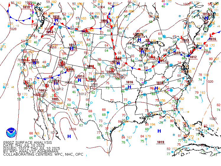
Excessive Rainfall Discussion
NWS Weather Prediction Center College Park MD
414 AM EDT Fri Jul 11 2025
Day 1
Valid 12Z Fri Jul 11 2025 - 12Z Sat Jul 12 2025
...THERE IS A SLIGHT RISK OF EXCESSIVE RAINFALL FOR PORTIONS OF THE
MID-MISSISSIPPI VALLEY AS WELL AS FOR PORTIONS OF THE CENTRAL HIGH
PLAINS...
...Mid-Mississippi Valley...
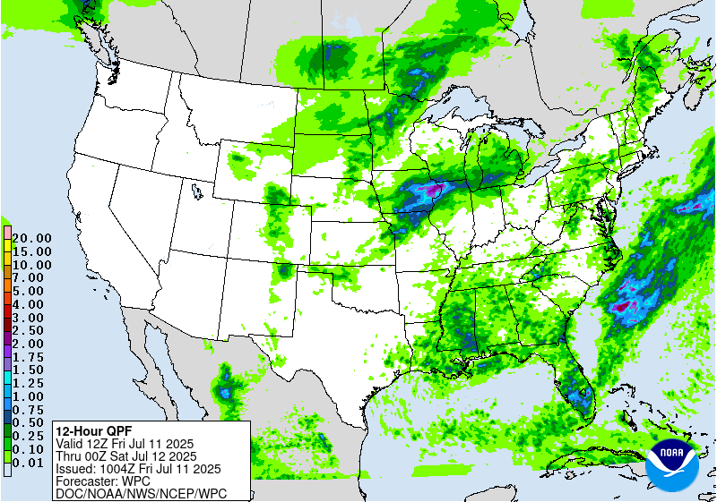
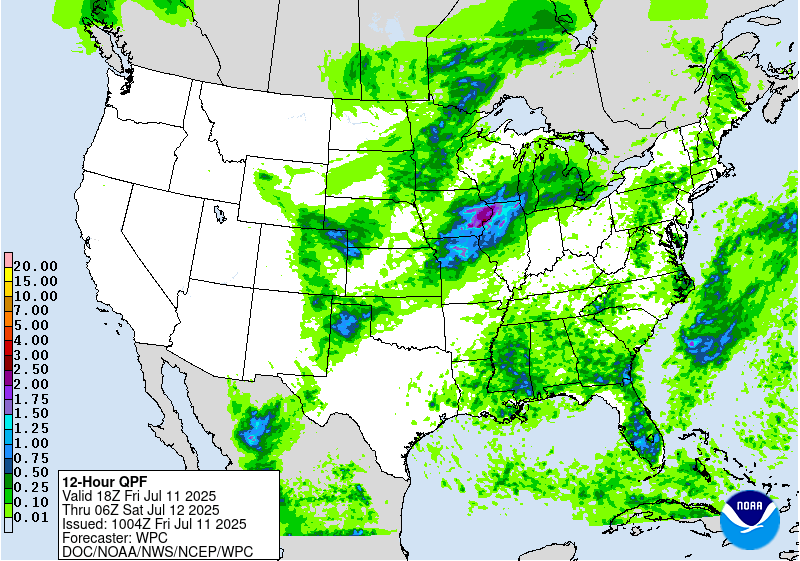
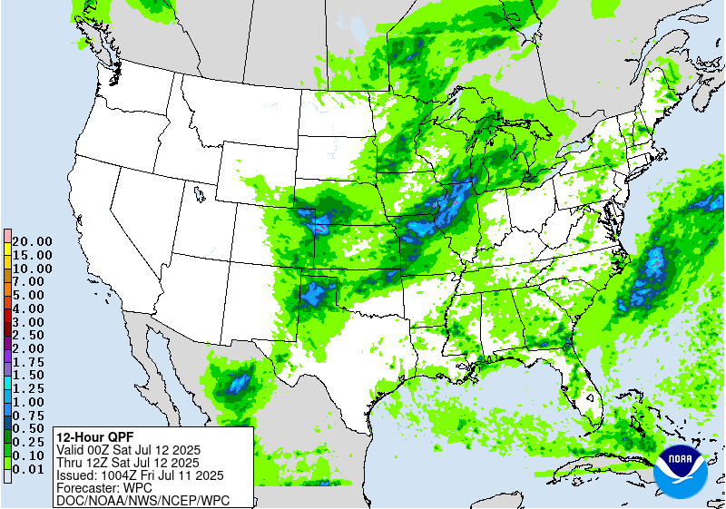
A robust southwesterly low level jet streaming from the Plains into
the Mid-Mississippi Valley will provide a steady supply of Gulf
moisture into the region today. Meanwhile, a potent upper level
shortwave trough will approach this area from the west. The
combination of abundant moisture, instability, and forcing from the
shortwave will lead to numerous thunderstorms from northern
Missouri through eastern Iowa, northern Illinois, and far southern
Wisconsin, including the Chicagoland area. An MCS moving across
Iowa this morning will weaken in the morning daylight hours in
typical behavior for MCSs. Rainfall totals yesterday in the area
ranged from 1-4 inches, with the highest amounts across northern
Illinois west of Chicago. This rainfall has likely contributed to
saturating the soils in this area. Thus, the additional rainfall
forecast for this area should result in widely scattered flash
flooding. A higher-end Slight remains in place with only minor
changes from inherited, namely to trim up the southern end of the
Slight along the Kansas/Missouri border.
Showers and thunderstorms are likely to develop over central Iowa
as early as early this afternoon. As additional storms from in
northern Missouri, and track northeastward along the Mississippi
River, the potential for training storms will increase as the line
of showers and storms moves into northern Illinois. Backbuilding
may continue supporting additional thunderstorm formation as far
south as St. Louis this evening. This will likely allow the
potential for training storms to persist, increasing the flash
flooding threat.
...Central High Plains...
As a strong shortwave trough digs southeastward across the northern
Plains, divergence at the base of the trough will increase the
lift, supporting storms across northeastern Colorado this afternoon
and evening. Meanwhile, typical leeside troughing will support
thunderstorm formation immediately downwind of the Front Range,
generally between Cheyenne and Denver along I-25. Storms may
initially form as early as 22Z/4pm MDT. As the storms move east off
the Front Range, they will encounter increasingly favorable lift
from the shortwave, as well as some Gulf moisture tracking
northward up the Plains. This will allow the storms to organize and
grow upscale in coverage and heavy rain potential. It is in this
region near the Colorado/Nebraska/Kansas tripoint which will have
the greatest threat for flash flooding with some limited potential
for training. With very low FFGs, especially across northeastern
Colorado (1-1.5 in/hr), a Slight Risk upgrade was hoisted with this
update. Some of the guidance suggests the storms will persist well
into tonight generally across far northwestern Kansas, so the
Slight Risk area includes that area as well.
Wegman
Day 1 threat area:
www.wpc.ncep.noaa.gov/qpf/94epoints.txt
Excessive Rainfall Discussion
NWS Weather Prediction Center College Park MD
414 AM EDT Fri Jul 11 2025
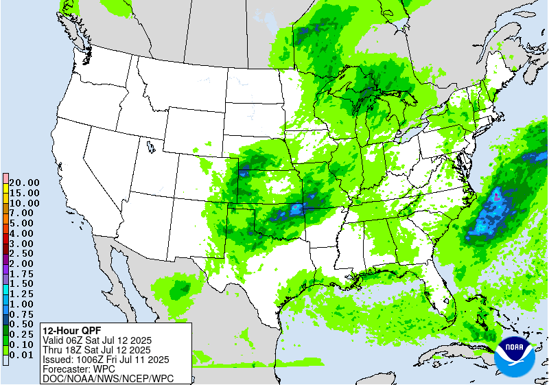
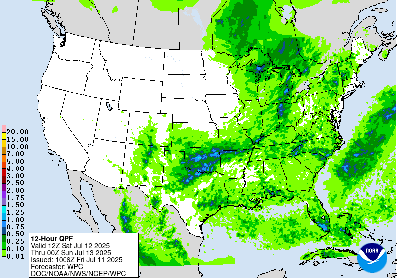
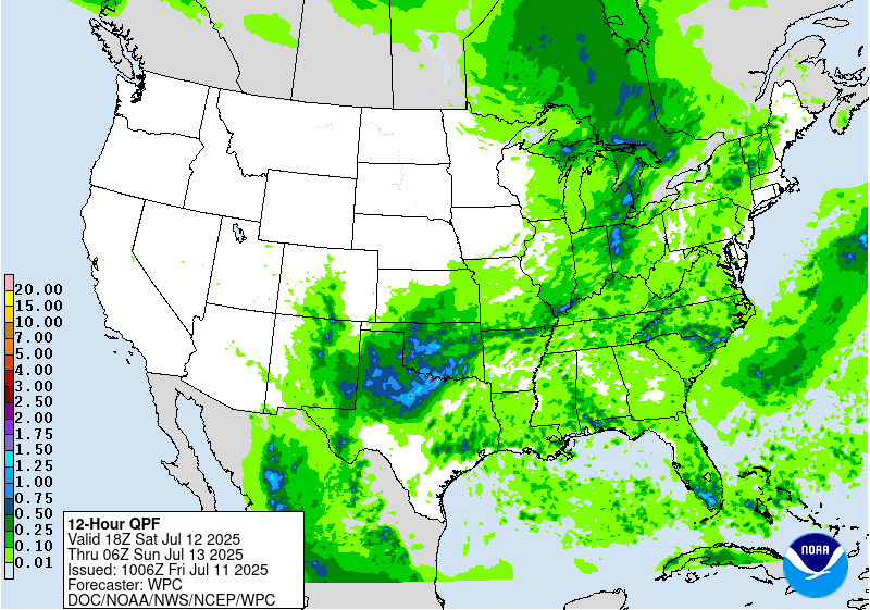
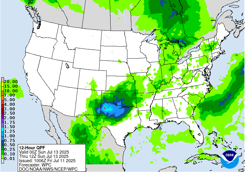
Day 2
Valid 12Z Sat Jul 12 2025 - 12Z Sun Jul 13 2025
...THERE IS A SLIGHT RISK OF EXCESSIVE RAINFALL FOR PORTIONS OF THE
SOUTHERN PLAINS...
As the northern stream shortwave that will bring heavy rainfall to
portions of the Midwest Friday pushes into the Great Lakes, the
southern end of that shortwave trough will get hung up across the
southern Plains. The trough will be supported by convection on the
nose of a potent LLJ transporting abundant Gulf moisture across
much of Texas and Oklahoma. This will allow a secondary shortwave
to develop, only moving very slowly across north Texas and Oklahoma
on Saturday. Early morning convection may be ongoing in the area at
the start of the period, which will likely weaken through the
morning. New convection will develop with typical peak afternoon
heating across north Texas and Oklahoma. Coverage and intensity
will peak across the area Saturday afternoon. Light and variable
steering flow will cause numerous storm interactions as clusters of
storms move in differing directions, greatly increasing the
likelihood for interactions between storms. Variability in the
placement of the storms is high in general, but there is some
agreement that by the overnight hours, the focus will be in far
northern Texas/southern Panhandle. This will likely keep the focus
of heaviest rain in the Childress/Wichita Falls area, generally
east of Lubbock and southwest of Oklahoma City. This area is in a
higher-end Slight, with considerable potential for a possible
Moderate Risk upgrade in the coming days, as this includes some
hard-hit areas from recent heavy rains.
There is considerable uncertainty as to exactly where the heaviest
and most persistent storms will form, but the general consensus is
to keep most of the rain north of the hardest hit areas of Kerr
County. That said, there are at least a few of the high-resolution
models suggesting heavy rain will get that far south, so the area
remains in a Marginal to Slight risk. Residents and first
responders should keep a close eye on the forecast over the next 24
hours.
Wegman
Day 2 threat area:
www.wpc.ncep.noaa.gov/qpf/98epoints.txt
Excessive Rainfall Discussion
NWS Weather Prediction Center College Park MD
414 AM EDT Fri Jul 11 2025
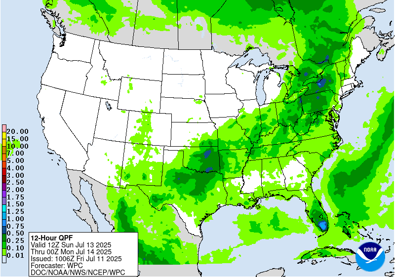
Day 3
Valid 12Z Sun Jul 13 2025 - 12Z Mon Jul 14 2025
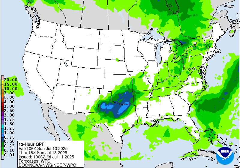
...THERE IS A SLIGHT RISK OF EXCESSIVE RAINFALL FOR PORTIONS OF THE
SOUTHERN PLAINS AS WELL AS FOR PORTIONS OF THE MID-ATLANTIC...
...Southern Plains...
A Slight Risk of excessive rainfall is in effect for many of the
same areas highlighted in the Day 2/Saturday ERO, for much of
northern Texas and Oklahoma. For now, rainfall amounts come down
quite a bit on Sunday as compared to Saturday. Thus, the flooding
potential will be significantly dependent on how the forecast
rainfall compares with Saturday, as well as how much rain actually
falls in the Slight Risk area on Saturday. Thus, for now, a Slight
Risk upgrade was introduced due to the likelihood for additional
strong thunderstorms in this area. Atmospheric moisture amounts
will increase on Sunday as compared with Saturday. The upper level
shortwave that forced the storms on Saturday will likely get left
behind and cutoff from the primary jet flow on Sunday. This slow
moving drift of the forcing should allow the storms to also remain
slow moving, and with increased moisture, the heavy rain potential
will very much still be in place on Sunday. Thus, there is some
expectation that forecast rainfall amounts in this area will
increase with time. Should this continue to be in the same area as
Saturday's storms, then it's likely additional upgrades will be
needed with future updates.
...Mid-Atlantic...
The shortwave that brought heavy rains across the Midwest on Friday
and Saturday will continue into the Mid-Atlantic and Northeast on
Sunday. By Sunday the shortwave will be lifting northeastward and
becoming more negatively tilted. This will increase the associated
divergence and lift. Meanwhile, plentiful Gulf/Atlantic moisture
will stream northward ahead of the shortwave, as PWATs in some
areas exceed 2 inches. This very high level of atmospheric moisture
will support a renewed round of heavy rain from strong
thunderstorms from the DMV north across much of Pennsylvania and
upstate New York. For New York, being both at the nose of the low
level jet and in the area of greatest upper level forcing will
further increase the likelihood for training heavy thunderstorms.
Meanwhile in the DMV, while overall coverage of storms will be
lesser, given the recent storms (and likely isolated to widely
scattered coverage both Friday and Saturday), a Slight Risk was
introduced for this portion of the Mid-Atlantic. The greatest flash
flooding potential will be up towards the eastern Finger
Lakes/Central New York, and additional upgrades in this area appear
likely, especially with low FFGs already in place.
Wegman
Day 3 threat area:
www.wpc.ncep.noaa.gov/qpf/99epoints.txt
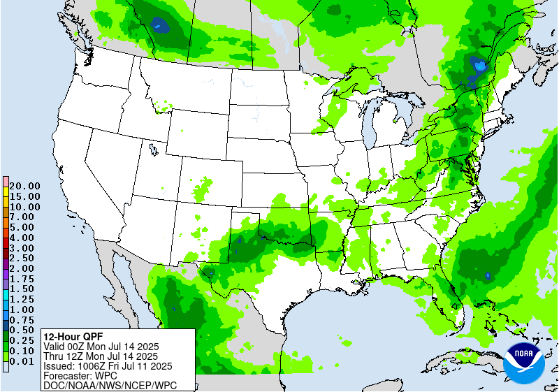
Extended Forecast Discussion
NWS Weather Prediction Center College Park MD
302 AM EDT Fri Jul 11 2025
A cold front through the East will bring showers and storms to
this region through Monday before the front dissipates, and a
marginal risk for excessive rainfall remains in place for the day
4/Monday Excessive Rainfall Outlook (ERO). Upper level energy
across Texas will continue a heavy rainfall threat into Monday as
well, with another marginal risk for portions of west and central
Texas on the ERO for Monday.
To the north, a cold front through the northern/central Plains and
eastward next week will support showers and thunderstorms with
ample moisture and instability resulting in a heavy to excessive
rainfall threat. A marginal risk is highlighted for parts of the
Upper Midwest on Monday, expanding across much of the Upper Midwest
by Tuesday, though still with plenty of uncertainty in exactly
where the heavier rain falls. This activity should move east into
the Ohio Valley and the East Coast next Wednesday and Thursday.
Monsoonal moisture looks to return to the Southwest/Four
Corners/southern Rockies region later in the week.
Elsewhere, upper level energy over Florida will lead to daily
heavy rainfall threats, with some guidance indicating several
inches of rain over much of the Peninsula over a couple of days.
There is significant uncertainty though in exactly how much rain
will fall, and with high flash flood values, maintained just broad
marginals over the state for the Monday and Tuesday ERO periods.
Hot weather will remain for much of the western U.S. through
Monday as upper ridging persists. Daily maximums will be above
normal with many locations climbing into the 100s and 110s for the
Desert Southwest, and nearing/exceeding 100F farther north in
interior/lower elevation areas of the Great Basin. Temperatures
will moderate below normal by Tuesday for the northern Plains with
high temperatures 15 to 25 degrees below normal for Tuesday and
Wednesday. Temperatures look to be a few degrees cooler than
average for the south- central U.S. for much of next week as clouds
and rain hold temperatures down. The Northeast will see a return
to above normal temperatures on Tuesday after the trough clears.
Meanwhile the Southeast should be near normal to a few degrees
above, for typical summer heat and humidity.
Santorelli


