Excessive Rainfall Discussion
NWS Weather Prediction Center College Park MD
416 AM EDT Wed Jul 16 2025
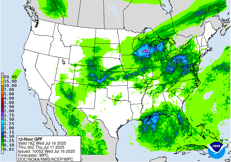
Day 1
Valid 12Z Wed Jul 16 2025 - 12Z Thu Jul 17 2025
...THERE IS A SLIGHT RISK OF EXCESSIVE RAINFALL FOR PORTIONS OF THE
MID-ATLANTIC STATES, THE CENTRAL PLAINS, AND THE UPPER MIDWEST...
...Central High Plains through the Great Lakes...
Return flow around a broad mid-level ridge centered off the
Atlantic coast will continue to result in a plume of exceptional
moisture and instability rotating across much of the CONUS. Today,
this plume of thermodynamics will stretch from Texas into the Upper
Midwest and then into New England, where PWs of 1.5 to 2.25 inches
overlapping pools of MUCAPE exceeding 2000 J/kg will reside. Into
this plume, a dissipating stationary front will drop southeast,
while a secondary front approaches from the NW in response to
subtle height falls in response to broad but increasing troughing
over the Northern Plains. This will result in squeezed mid-level
flow from WSW to ENE from Texas into New England, through which
multiple shortwaves will traverse along the boundary to
additionally enhance ascent. Although much of the area will
experienced scattered convection, there is likely to be an axis of
enhanced organization from Kansas into Wisconsin.
In this region, multiple MCSs driven by connectively enhanced
shortwaves will move across these areas with focused heavy rainfall,
aided by waves of low pressure which may develop along the front.
Although there continues to be some latitudinal and longitudinal
spread with the placement of these MCSs which will be the primary
driver of the flash flood risk, a slowly veering 30-40kt LLJ
emerging from the Southern Plains will provide the focus for
development through convergence and isentropic lift. The models
suggest potentially two foci for heaviest rain, one in Kansas and a
second axis from southern MN into WI, but anywhere across this
region could experience short term training through Corfidi vectors
that are aligned to the mean wind and the front (MN and WI) or anti-
parallel to the mean wind (KS). With rain rates likely reaching 1-
2"/hr, if not locally higher, this could result in instances of
flash flooding and the inherited SLGT risk was modified for new
guidance to cover the highest probabilities for 3" and locally 5"
today.
...Ohio Valley into the Mid-Atlantic...
Farther east into the thermodynamic plume mentioned above, a
secondary maxima of heavy rainfall is likely from Ohio into
Pennsylvania and surrounding areas. This is where a shortwave is
progged to track overhead during peak heating and maximum
instability. This will not only drive enhanced ascent, but also
accelerate bulk shear to 30-35 kts which will force better storm
organization. 850mb inflow across this area will also strengthen,
potentially reaching 30-35 kts which will be 1.5 times the mean
0-6km wind, a signal for strong convergence. Although storms that
develop should remain progressive to the east, slower storm motions
during convective initiation are also possible. Regardless of the
exact behavior, multiple rounds are likely in many areas, and each
one will rainfall rates of around 2+"/hr (20-40% chance), leading
to total rainfall of 2-4" with locally higher amounts possible
(10-20% chance of 5" in both REFS and HREF, despite latitudinal
placement differences.) This falling atop saturated soils from
recent heavy rainfall will likely result in instances of flash
flooding once again today.
...Gulf Coast...
Invest 93L exiting the northern Florida peninsula this morning
will drift westward into the northern Gulf on Wednesday. The
accompanying mid-level inverted trough/tropical wave will be forced
due west as it remains south of an elongated ridge extending from
the Atlantic Ocean. There continues to be quite a bit of spread of
intensity of the accompanying surface reflection to this feature
(and NHC continues a 40% chance of development) but the track
guidance has converged moving just south of the coast through the
next few days. Regardless of the exact track and development of
this system, the accompanying tropical moisture plume (PWs 2.25 to
2.5 inches, as much as +3 sigma according to the GEFS) will spread
onshore to support showers and thunderstorms with heavy rainfall
rates of 2-3"/hr. There continues to be uncertainty into how far
north any of this moisture will spread due to subsidence/dry air
beneath the ridge to the north, but guidance has begun to focus a
relative maxima across southeast LA, and potentially as far east as
Mobile Bay, AL. In this corridor, both the HREF and REFS
probabilities for 5"/24 hrs exceed 25%, and the inherited SLGT risk
has been cosmetically adjusted for this area, embedded within a
larger surrounding MRGL risk.
...Desert Southwest...
Active convection is likely again today across the Southwest as
the mid-level ridge weakens and weak impulses, some of which are
convectively enhanced by thunderstorms from Tuesday, move across
the region. PWs are expected to continue to be above 1.25", highest
across southern AZ, but with a slow decrease in intensity and
coverage of this PW plume. Additionally, probabilities for CAPE
exceeding 500 J/kg are lower and confined east of the greatest
moisture today, indicating that coverage and intensity of
thunderstorms should be less than what occurred Tuesday. Despite
that, convection should still be relatively widespread, but
possibly displaced north of previous activity, although any weak
remnant MCVs could enhance local ascent leading to local flash
flood impacts, most likely should any thunderstorms with 0.5"/hr
rain rates track across burn scars or sensitive terrain.
Weiss
Day 1 threat area:
www.wpc.ncep.noaa.gov/qpf/94epoints.txt
Excessive Rainfall Discussion
NWS Weather Prediction Center College Park MD
416 AM EDT Wed Jul 16 2025
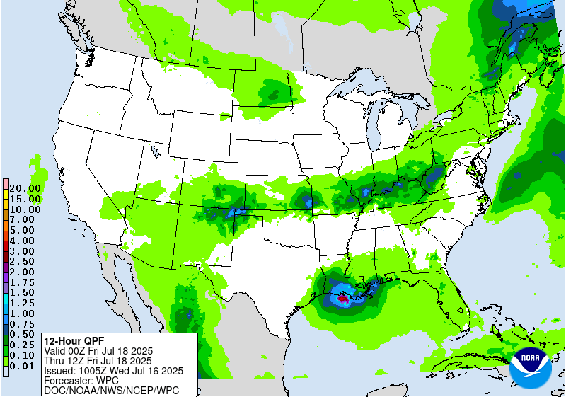
Day 2
Valid 12Z Thu Jul 17 2025 - 12Z Fri Jul 18 2025
...THERE IS A SLIGHT RISK OF EXCESSIVE RAINFALL FOR THE CENTRAL
GULF COAST AND PORTIONS OF THE FOUR CORNERS STATES...
...Gulf Coast...
All eyes will be on Invest 93L for which NHC has placed a 40%
chance of development across the northern Gulf. The guidance is
converging on the track of this invest, although uncertainty
remains high as the system has not developed yet. Still, there is
increasing confidence in the track of this system, and the mid-
level circulation should begin to track NW on Thursday into a
weakness which develops in the ridge to the north. This will allow
for more widespread precipitation to spread onshore as the northern
subsidence/dryness begins to erode and the accompanying tropical
moisture plume pivots northward. This will support training of
tropical rain showers lifting into Louisiana, with rainfall rates
2-3"/hr supported by deep column saturation noted in forecast
soundings and PWs approaching 2.5 inches. Additionally, forecast
soundings indicate that the mean winds through 300mb are quite
weak, and this indicates that if the system can organize more
quickly and intensify, low-level moist inflow could quickly exceed
the mean wind to enhance ascent, which would additionally create
more widespread heavy rainfall. GEFS and ECENS probabilities both
indicate a low-end risk (10-15%), as does the LREF from DESI, but
this may under-forecasting the true threat in the tropical
airmass, as several deterministic models show 3-6" across southern
Louisiana on Thursday. At this time opted to maintain the SLGT risk
for this area, but should the system begin to organize and models
converge on a more aggressive solution, an upgrade may be needed
for D2 (a MDT risk is already in effect for D3).
...Central Plains through the Northeast...
A cold front will sag slowly southeast, pushed by a broad but
subtly amplifying trough along the Canadian/United States border.
This trough will impinge into broad mid-level ridging which will
remain elongated west from the Carolinas, leading to pinched flow
generally aligned WSW to ENE from the Central Plains into the Mid-
Atlantic and Northeast. Through this pinched mid-level axis,
multiple vorticity impulses are progged to cross from west to east,
each one interacting with the low-level baroclinic boundary to
enhance ascent leading to scattered to widespread thunderstorms.
Convection which develops on Thursday will likely contain intense
rain rates as thermodynamics in the vicinity of this front remain
impressive. PWs are progged to exceed 2 inches, which is above the
90th percentile from NAEFS, and be collocated with a MUCAPE axis of
2000-3000 J/kg, or higher. These intense thermodynamics will
support rainfall rates that could reach 2-3"/hr (as high as 30%
chance from the HREF through 00Z Friday), with cell training likely
as 0-6km mean winds align parallel to the front. Additionally, bulk
shear magnitude of 20-30 kts will support storm organization,
especially beneath any of the more powerful impulses moving through
the flow.
While at this time there is no clear signal, and hence
too much uncertainty, for any local SLGT risk areas, it is possible
that some targeted SLGT risk upgrades may be required with later
issuances. This would be most likely across parts of KS/MO where a
morning MCS decays and leaves a lingering boundary to enhance
thunderstorms with training, or potentially farther east into the
Ohio Valley/Central Appalachians where training atop more sensitive
soils may occur.
...Four Corners...
Elongated ridge extending from the Carolinas through the southern
High Plains will interact with a closed low lifting northward from
Baja into southern California on Thursday. This will squeeze
intensifying deep-layer southerly flow out of Mexico and the Gulf
of California, driving impressive moisture advection northward into
the Southwest. PWs within this plume will exceed 1.25 inches as
IVT surges above the 90th percentile, at least locally, according
to NAEFS, but collocated MUCAPE is progged to be modest as
reflected by SREF 500 J/kg probabilities peaking around 40% in AZ,
although higher across northeast NM. While many of the
deterministic models predict at least scattered convection during
the day, the heaviest rainfall may be across northern AZ/northern
NM as the 850mb inflow convergences into weaker wind speeds, which
is more effectively overlapped by upper diffluence to enhance
ascent. This suggests that the current MRGL risk is still
appropriate for most of the area, however, a targeted SLGT risk has
been collaborated for northeast NM and far Southeast CO where a
vorticity lobe lifting N/NE will interact with the greater
instability and the tail end of the lingering front to provide a
focus for more organized convection.
Weiss
Day 2 threat area:
www.wpc.ncep.noaa.gov/qpf/98epoints.txt
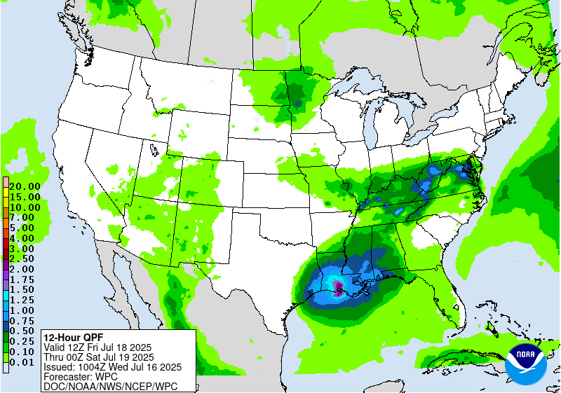
Excessive Rainfall Discussion
NWS Weather Prediction Center College Park MD
416 AM EDT Wed Jul 16 2025
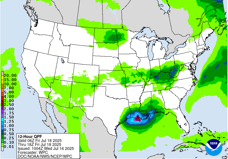
Day 3
Valid 12Z Fri Jul 18 2025 - 12Z Sat Jul 19 2025
...THERE IS A MODERATE RISK OF EXCESSIVE RAINFALL FOR THE CENTRAL
GULF COAST...
...Gulf Coast...
Concern for flash flooding Friday revolves around Invest 93L which
will likely begin its turn to the NW, regardless of how it
develops. While guidance has tended to back off on the intensity
and associated precipitation with this feature, there continues to
be a lot of uncertainty into this forecast and NHC has maintained a
40% chance of development over the next few days. Regardless of
development, the associated tropical moisture plume will support
heavy rainfall rates of 2-3"/hr, with some training likely on the
upwind side of this feature. The GEFS and ECENS ensembles are
modest with the rainfall Friday(only 10% chance for 3" of rain),
but after coordination with the affected WFOs, the MDT risk was
maintained with only minor cosmetic adjustments for consistent
messaging and the potential if this system does become more
organized.
...Mid-Mississippi Valley...
A stationary front Thursday will gradually lift northward on
Friday, moving across the Mid-Mississippi Valley and into the Upper
Midwest. This boundary will surge north in response to both the
expanding ridge to the southeast and an intensification of the
850mb LLJ reaching 30+ kts out of the Gulf and returning through
the southern Plains. At the same time, a shortwave impulse,
potentially convectively reinforced from prior thunderstorms, will
move along the front to enhance ascent, resulting in an axis of
thunderstorms which may congeal into an MCS Friday night. There
remains some uncertainty into both the placement and speed of this
MCS, but PWs elevating to above 1.75 inches and MUCAPE pushing
above 3000 J/kg will support rain rates of 1-2"/hr, if not locally
higher. This could produce more than 3" of rain where any training
can occur, and the SLGT risk was tailored to best match the GEFS
and ECENS probabilities for 3"/24hrs.
...Southwest...
An active monsoon day is expected Friday as a potent vorticity
maxima lifts northward over the Four Corners, embedded within
pinched southerly mid-level flow between a ridge to the east and
closed low over southern CA to the west. The key difference in the
evolution of the synoptic pattern Friday is a push west of the
mid-level ridge, which should deflect higher moisture westward,
noted by a plume of 1.25" PWs lifting into southern NV, coincident
with a dramatic increase in SREF CAPE>500 J/kg probabilities as far
as southern UT. There is a lot of uncertainty in the potential for
convective coverage on Friday, but increasing bulk shear and
chaotic/weak storm motions will result in at least an isolated
flash flood risk as storms contain rainfall rates above 0.5"/hr. It
is possible, as well, that a targeted SLGT risk may be needed for
portions of the area with later issuances.
...Central Appalachians and Mid-Atlantic...
A cold front and wave of low pressure will dig slowly southward
from the Great Lakes into the region on Friday. This front will
move into an environment that will be favorable for heavy rainfall
noted by PWs above the 90th percentile according to NAEFS
collocated with MUCAPE of 1000-2000 J/kg. This will likely result
in scattered to numerous thunderstorms developing during the
aftn/eve, with rain rates of more than 2"/hr possible at times. The
guidance is highly variable both with the placement of the
strongest convection, as well as whether or not it can organize
beyond typical pulse type thunderstorms. Due to the uncertainty, no
SLGT risk has been raised at this time. However, increasing bulk
shear Friday evening and the potential for training along the front
could result in 2-3" of rain with locally higher amounts as
reflected by SREF/GEFS probabilities. If this occurs atop the most
vulnerable soils from recent rainfall, a targeted SLGT risk may be
needed for portions of the region.
Day 3 threat area:
www.wpc.ncep.noaa.gov/qpf/99epoints.txt
Extended Forecast Discussion
NWS Weather Prediction Center College Park MD
244 AM EDT Wed Jul 16 2025
The National Hurricane Center continues to monitor the potential
for tropical system development across the northern Gulf in the
short range period. The remnants of this energy (regardless of
development) may linger into next weekend, and could bring locally
heavy to excessive rainfall into at least Saturday. Despite the
relatively light QPFs forecast by the models, continued to maintain
a small slight risk across western Louisiana given the available
anomalous moisture and the forecasted heavy rains in the short
range.
A series of shortwaves and associated surface fronts through the
northern tier will continue to support showers and thunderstorms
from the northern Plains eastward to the Mid-Atlantic. This entire
area is encompassed by a broad marginal risk on the Excessive
Rainfall Outlooks with the warm and very moist airmass in place.
There is greater concern for training along a west to east oriented
nearly stationary boundary from the Midwest to the Central
Appalachians through the weekend, and a slight risk is in effect on
the Days 4 and 5 EROs for this region. Activity east of the
Rockies may overall shift east with a building ridge over the
Central U.S. but daily shower and thunderstorm threats will
continue into next week across the Great Lakes region and the East.
Farther south, ample monsoonal moisture will be in place across
the Southwest/Four Corners/southern Rockies region this weekend.
Marginal Risks remain across much of Arizona and New Mexico and
stretching into parts of Colorado and Utah. Areas like burn scars
and urban areas would be of greatest concern for flash flooding.
Monsoonal moisture may continue, but possibly slightly weaker, into
next week.
Temperatures in the High Plains to the northern/central Plains
looks to remain near or below normal (on the order of 5-10 degrees)
for this time of the year through much of the period, with some
moderation at times. Elsewhere, despite temperatures being only
modestly above normal, the persistence of ridging over the
Southeast will keep a moderate to major HeatRisk in place for the
region, with localized extreme impacts this weekend. This expands
westward into the Tennessee/Mississippi Valley and Central Plains
next week.
Santorelli


