Excessive Rainfall Discussion
NWS Weather Prediction Center College Park MD
857 PM EDT Wed Jul 16 2025
Day 1
Valid 01Z Thu Jul 17 2025 - 12Z Thu Jul 17 2025
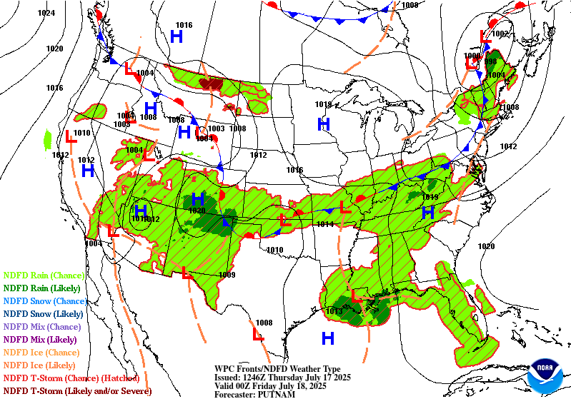
...THERE IS A SLIGHT RISK OF EXCESSIVE RAINFALL FOR PORTIONS OF
THE MID-ATLANTIC STATES, THE CENTRAL PLAINS, AND THE UPPER
MIDWEST...
...Central High Plains through the Great Lakes...
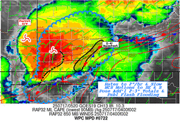
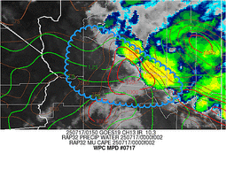
0100 UTC Update...Continue to remove the western edges of the
Slight and Marginal Risk areas across the Upper Midwest, while have
also made some tweaks to the Slight (removing SE Lower MI) based on
the latest observational and mesoanalysis trends.
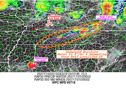
...Ohio Valley into the Mid-Atlantic...
0100 UTC Update...Minor adjustments were made to the Slight and
Marginal Risk areas, based on the latest observational and
mesoanalysis trends. 18Z HREF exceedance probabilities again
support the highest risk for any isolated/scattered areas of
excessive rainfall lingering through 04-05Z.
...Gulf Coast...
Invest 93L exiting the northern Florida peninsula this morning
will drift westward into the northern Gulf on Wednesday. The
accompanying mid-level inverted trough/tropical wave will be forced
due west as it remains south of an elongated ridge extending from
the Atlantic Ocean. There continues to be quite a bit of spread of
intensity of the accompanying surface reflection to this feature
(and NHC continues a 40% chance of development) but the track
guidance has converged moving just south of the coast through the
next few days. Regardless of the exact track and development of
this system, the accompanying tropical moisture plume (PWs 2.25 to
2.5 inches, as much as +3 sigma according to the GEFS) will spread
onshore to support showers and thunderstorms with heavy rainfall
rates of 2-3"/hr. There continues to be uncertainty into how far
north any of this moisture will spread due to subsidence/dry air
beneath the ridge to the north, but guidance has begun to focus a
relative maxima across southeast LA, and potentially as far east as
Mobile Bay, AL.
...Arizona and New Mexico...
2015Z Update...Based on the latest observational trends (visible
satellite and mosaic radar in particular), along with the latest
HREF and RRFS 1/3/6hr QPF exceedance probabilities...have expanded
the Marginal to include the Sacramento Mtns in NM. Another update
may be necessary to expand the Marginal north to capture the
convective clusters firing across portions of the Grand Canyon
Country in northern AZ.
Active convection is likely again today across the Southwest as
the mid-level ridge weakens and weak impulses, some of which are
convectively enhanced by thunderstorms from Tuesday, move across
the region. PWs are expected to continue to be above 1.25", highest
across southern AZ, but with a slow decrease in intensity and
coverage of this PW plume. Additionally, probabilities for CAPE
exceeding 500 J/kg are lower and confined east of the greatest
moisture today, indicating that coverage and intensity of
thunderstorms should be less than what occurred Tuesday. Despite
that, convection should still be relatively widespread, but
possibly displaced north of previous activity, although any weak
remnant MCVs could enhance local ascent leading to local flash
flood impacts, most likely should any thunderstorms with 0.5"/hr
rain rates track across burn scars or sensitive terrain.
Hurley/Weiss
Day 1 threat area:
www.wpc.ncep.noaa.gov/qpf/94epoints.txt
Excessive Rainfall Discussion
NWS Weather Prediction Center College Park MD
857 PM EDT Wed Jul 16 2025
Day 2
Valid 12Z Thu Jul 17 2025 - 12Z Fri Jul 18 2025
...THERE IS A SLIGHT RISK OF EXCESSIVE RAINFALL FOR THE CENTRAL
GULF COAST AND PORTIONS OF THE FOUR CORNERS STATES...
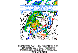
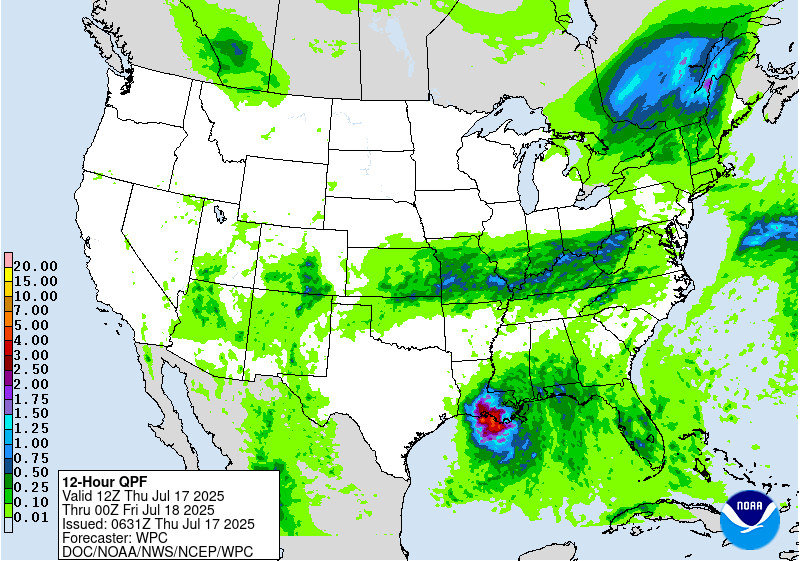
...2030 Update...
Along the Gulf Coast, primary adjustment to the overnight forecast
includes a subtle westward expansion of the Slight Risk area west
of LCH based on recent HREF and REFS output. Otherwise, overall
forecast thinking remains intact as deep tropical moisture with
2.25-2.5" PWATs drives very efficient hourly rainfall rates of
2-3"/hr within training showers and thunderstorms. The main
forecast challenge remains the placement of heaviest rainfall
amounts, as much of the high-res guidance straddles the coastline
with 4-7" (locally higher) of QPF.
Over the Central Plains and Ohio Valley, a broad Slight Risk was
introduced along a west-east oriented stationary front. Training
and backbuilding thunderstorm clusters are expected to emerge
tomorrow afternoon as several weak shortwave perturbations eject
eastward and interact with the front during peak diurnal heating. HREF
and REFS neighborhood probabilities depict 50-80% probabilities of
24 hour QPF exceeding 3" with this activity, albiet with some
spatial disagreement between the two. Regardless of exact placement
of QPF, the overlap of these storms with elevated soil moisture
across the region per NASA SPoRT (apart from today's storms)
should support scattered instances of flash flooding, and thus a
Slight Risk.
Asherman
...Previous Discussion...
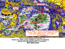
...Gulf Coast...
All eyes will be on Invest 93L for which NHC has placed a 40%
chance of development across the northern Gulf. The guidance is
converging on the track of this invest, although uncertainty
remains high as the system has not developed yet. Still, there is
increasing confidence in the track of this system, and the mid-
level circulation should begin to track NW on Thursday into a
weakness which develops in the ridge to the north. This will allow
for more widespread precipitation to spread onshore as the northern
subsidence/dryness begins to erode and the accompanying tropical
moisture plume pivots northward. This will support training of
tropical rain showers lifting into Louisiana, with rainfall rates
2-3"/hr supported by deep column saturation noted in forecast
soundings and PWs approaching 2.5 inches. Additionally, forecast
soundings indicate that the mean winds through 300mb are quite
weak, and this indicates that if the system can organize more
quickly and intensify, low-level moist inflow could quickly exceed
the mean wind to enhance ascent, which would additionally create
more widespread heavy rainfall. GEFS and ECENS probabilities both
indicate a low-end risk (10-15%), as does the LREF from DESI, but
this may under-forecasting the true threat in the tropical
airmass, as several deterministic models show 3-6" across southern
Louisiana on Thursday.
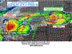
...Central Plains through the Northeast...
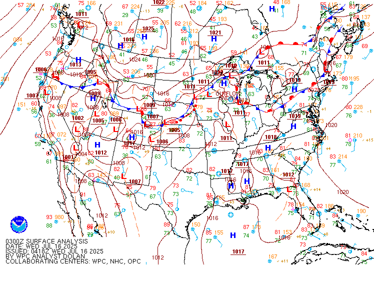
A cold front will sag slowly southeast, pushed by a broad but
subtly amplifying trough along the Canadian/United States border.
This trough will impinge into broad mid-level ridging which will
remain elongated west from the Carolinas, leading to pinched flow
generally aligned WSW to ENE from the Central Plains into the Mid-
Atlantic and Northeast. Through this pinched mid-level axis,
multiple vorticity impulses are progged to cross from west to east,
each one interacting with the low-level baroclinic boundary to
enhance ascent leading to scattered to widespread thunderstorms.
Convection which develops on Thursday will likely contain intense
rain rates as thermodynamics in the vicinity of this front remain
impressive. PWs are progged to exceed 2 inches, which is above the
90th percentile from NAEFS, and be collocated with a MUCAPE axis of
2000-3000 J/kg, or higher. These intense thermodynamics will
support rainfall rates that could reach 2-3"/hr (as high as 30%
chance from the HREF through 00Z Friday), with cell training likely
as 0-6km mean winds align parallel to the front. Additionally, bulk
shear magnitude of 20-30 kts will support storm organization,
especially beneath any of the more powerful impulses moving through
the flow.
While at this time there is no clear signal, and hence
too much uncertainty, for any local SLGT risk areas, it is possible
that some targeted SLGT risk upgrades may be required with later
issuances. This would be most likely across parts of KS/MO where a
morning MCS decays and leaves a lingering boundary to enhance
thunderstorms with training, or potentially farther east into the
Ohio Valley/Central Appalachians where training atop more sensitive
soils may occur.
...Four Corners...
Elongated ridge extending from the Carolinas through the southern
High Plains will interact with a closed low lifting northward from
Baja into southern California on Thursday. This will squeeze
intensifying deep-layer southerly flow out of Mexico and the Gulf
of California, driving impressive moisture advection northward into
the Southwest. PWs within this plume will exceed 1.25 inches as
IVT surges above the 90th percentile, at least locally, according
to NAEFS, but collocated MUCAPE is progged to be modest as
reflected by SREF 500 J/kg probabilities peaking around 40% in AZ,
although higher across northeast NM. While many of the
deterministic models predict at least scattered convection during
the day, the heaviest rainfall may be across northern AZ/northern
NM as the 850mb inflow convergences into weaker wind speeds, which
is more effectively overlapped by upper diffluence to enhance
ascent. This suggests that the current MRGL risk is still
appropriate for most of the area, however, a targeted SLGT risk has
been collaborated for northeast NM and far Southeast CO where a
vorticity lobe lifting N/NE will interact with the greater
instability and the tail end of the lingering front to provide a
focus for more organized convection.
Weiss
Day 2 threat area:
www.wpc.ncep.noaa.gov/qpf/98epoints.txt
Excessive Rainfall Discussion
NWS Weather Prediction Center College Park MD
857 PM EDT Wed Jul 16 2025
Day 3
Valid 12Z Fri Jul 18 2025 - 12Z Sat Jul 19 2025
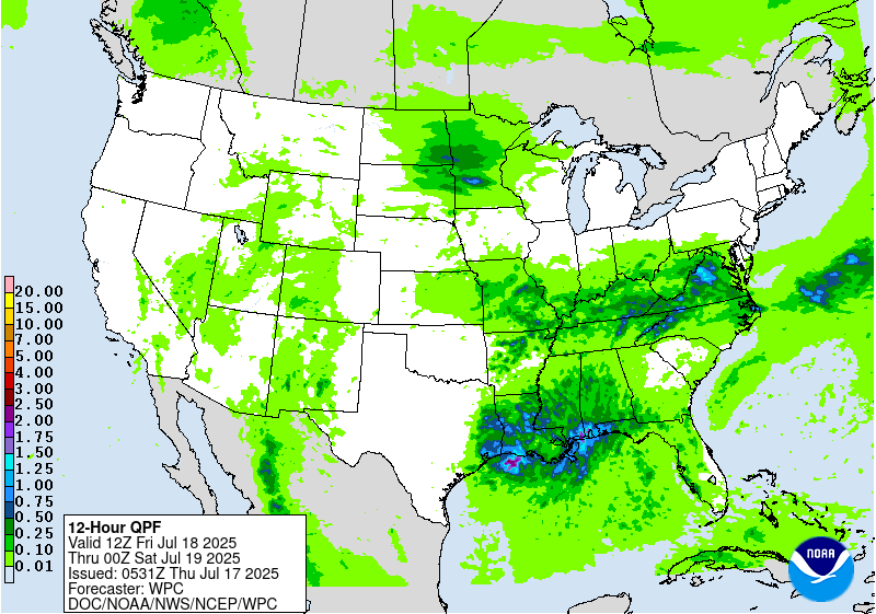
...THERE IS A MODERATE RISK OF EXCESSIVE RAINFALL FOR THE CENTRAL
GULF COAST...
...2030 Update...
Little change to the overall forecast across the Gulf Coast. The
eastern edge of the Moderate Risk was trimmed slightly to fall
along the LIX-LCH border to better highlight the area of best
overlap with heavy rainfall from the Day 2 period. Otherwise, the
Slight Risk was adjusted northward in the Midwest to reflect the
shift in QPF, although confidence in specifics is somewhat low as
of now.
Asherman
...Previous Discussion...
...Gulf Coast...
Concern for flash flooding Friday revolves around Invest 93L which
will likely begin its turn to the NW, regardless of how it
develops. While guidance has tended to back off on the intensity
and associated precipitation with this feature, there continues to
be a lot of uncertainty into this forecast and NHC has maintained a
40% chance of development over the next few days. Regardless of
development, the associated tropical moisture plume will support
heavy rainfall rates of 2-3"/hr, with some training likely on the
upwind side of this feature. The GEFS and ECENS ensembles are
modest with the rainfall Friday(only 10% chance for 3" of rain),
but after coordination with the affected WFOs, the MDT risk was
maintained with only minor cosmetic adjustments for consistent
messaging and the potential if this system does become more
organized.
...Mid-Mississippi Valley...
A stationary front Thursday will gradually lift northward on
Friday, moving across the Mid-Mississippi Valley and into the Upper
Midwest. This boundary will surge north in response to both the
expanding ridge to the southeast and an intensification of the
850mb LLJ reaching 30+ kts out of the Gulf and returning through
the southern Plains. At the same time, a shortwave impulse,
potentially convectively reinforced from prior thunderstorms, will
move along the front to enhance ascent, resulting in an axis of
thunderstorms which may congeal into an MCS Friday night. There
remains some uncertainty into both the placement and speed of this
MCS, but PWs elevating to above 1.75 inches and MUCAPE pushing
above 3000 J/kg will support rain rates of 1-2"/hr, if not locally
higher. This could produce more than 3" of rain where any training
can occur, and the SLGT risk was tailored to best match the GEFS
and ECENS probabilities for 3"/24hrs.
...Southwest...
An active monsoon day is expected Friday as a potent vorticity
maxima lifts northward over the Four Corners, embedded within
pinched southerly mid-level flow between a ridge to the east and
closed low over southern CA to the west. The key difference in the
evolution of the synoptic pattern Friday is a push west of the
mid-level ridge, which should deflect higher moisture westward,
noted by a plume of 1.25" PWs lifting into southern NV, coincident
with a dramatic increase in SREF CAPE>500 J/kg probabilities as far
as southern UT. There is a lot of uncertainty in the potential for
convective coverage on Friday, but increasing bulk shear and
chaotic/weak storm motions will result in at least an isolated
flash flood risk as storms contain rainfall rates above 0.5"/hr. It
is possible, as well, that a targeted SLGT risk may be needed for
portions of the area with later issuances.
...Central Appalachians and Mid-Atlantic...
A cold front and wave of low pressure will dig slowly southward
from the Great Lakes into the region on Friday. This front will
move into an environment that will be favorable for heavy rainfall
noted by PWs above the 90th percentile according to NAEFS
collocated with MUCAPE of 1000-2000 J/kg. This will likely result
in scattered to numerous thunderstorms developing during the
aftn/eve, with rain rates of more than 2"/hr possible at times. The
guidance is highly variable both with the placement of the
strongest convection, as well as whether or not it can organize
beyond typical pulse type thunderstorms. Due to the uncertainty, no
SLGT risk has been raised at this time. However, increasing bulk
shear Friday evening and the potential for training along the front
could result in 2-3" of rain with locally higher amounts as
reflected by SREF/GEFS probabilities. If this occurs atop the most
vulnerable soils from recent rainfall, a targeted SLGT risk may be
needed for portions of the region.
Day 3 threat area:
www.wpc.ncep.noaa.gov/qpf/99epoints.txt
Extended Forecast Discussion
NWS Weather Prediction Center College Park MD
256 AM EDT Thu Jul 17 2025
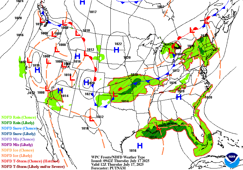
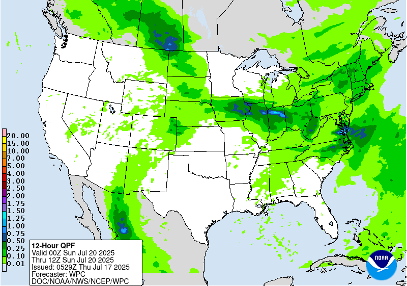
A series of shortwaves and associated surface fronts through the
northern tier will continue to support showers and thunderstorms
from the northern Plains eastward to the Mid-Atlantic/Southeast.
This entire area is encompassed by broad marginal risks on the
Excessive Rainfall Outlooks (EROs) with the warm and very moist
airmass in place. There continues to be a good signal for heavy
rain and the potential for flash flooding from portions of the
Midwest to the Central Appalachians beginning this weekend at the
end of the short range and lasting into Sunday. For the Day
4/Sunday ERO graphic, a higher-end slight risk is depicted in this
area where thunderstorms could train along a nearly stationary
frontal boundary. It is possible a moderate risk may be needed in
future updates.
Elsewhere, the heavy rainfall threat lessens by Monday onward as
this whole system shifts eastward, but have maintained a broad
marginal risk on the Day 5/Monday ERO from the northern Plains to
the Southeast. In the Southwest, monsoonal moisture will be in
place into early next week. Marginal Risks remain across much of
Arizona and New Mexico for Sunday/Monday EROs. Areas like burn
scars and urban areas would be of greatest concern for flash
flooding. A brief break in the moisture flow may be possible before
picking up again later next week.
There is growing concern for a persistent and potentially
dangerous heat wave across portions of the Southeast this weekend
and expanding into the Tennessee Valley and Midwest next week.
Record setting temperatures are possible, with hot and humid days
and little relief overnight leading to widespread areas of Major
HeatRisk, with localized extreme values. See Key Messages being
issued by WPC for the latest on this Heat Wave, which may persist
beyond the medium range period as well, per Climate Prediction
Center Outlooks.
Santorelli
Extended Forecast Discussion
NWS Weather Prediction Center College Park MD
256 AM EDT Thu Jul 17 2025
A series of shortwaves and associated surface fronts through the
northern tier will continue to support showers and thunderstorms
from the northern Plains eastward to the Mid-Atlantic/Southeast.
This entire area is encompassed by broad marginal risks on the
Excessive Rainfall Outlooks (EROs) with the warm and very moist
airmass in place. There continues to be a good signal for heavy
rain and the potential for flash flooding from portions of the
Midwest to the Central Appalachians beginning this weekend at the
end of the short range and lasting into Sunday. For the Day
4/Sunday ERO graphic, a higher-end slight risk is depicted in this
area where thunderstorms could train along a nearly stationary
frontal boundary. It is possible a moderate risk may be needed in
future updates.
Elsewhere, the heavy rainfall threat lessens by Monday onward as
this whole system shifts eastward, but have maintained a broad
marginal risk on the Day 5/Monday ERO from the northern Plains to
the Southeast. In the Southwest, monsoonal moisture will be in
place into early next week. Marginal Risks remain across much of
Arizona and New Mexico for Sunday/Monday EROs. Areas like burn
scars and urban areas would be of greatest concern for flash
flooding. A brief break in the moisture flow may be possible before
picking up again later next week.
There is growing concern for a persistent and potentially
dangerous heat wave across portions of the Southeast this weekend
and expanding into the Tennessee Valley and Midwest next week.
Record setting temperatures are possible, with hot and humid days
and little relief overnight leading to widespread areas of Major
HeatRisk, with localized extreme values. See Key Messages being
issued by WPC for the latest on this Heat Wave, which may persist
beyond the medium range period as well, per Climate Prediction
Center Outlooks.
Santorelli


